
Geophysical Evidence for Carbonate Platform Periphery Gravity Flows in the Xisha Islands, South China Sea
2022-08-17 05:35:54BAIHongxinSUNYueWANGDaweiWANGWeiweiandWUShiguo
BAI Hongxin, SUN Yue, WANG Dawei, 3), *, WANG Weiwei, and WU Shiguo, 3)
Geophysical Evidence for Carbonate Platform Periphery Gravity Flows in the Xisha Islands, South China Sea
BAI Hongxin1), 2), SUN Yue1), 3), WANG Dawei1), 2), 3), *, WANG Weiwei4), and WU Shiguo1), 2), 3)
1),,572000,2),519000,3),100049,4),,266580,
High-resolution bathymetric and partial seismic data were utilized to determine the characteristics and distribution of mass-transport deposits (MTDs) in the Xisha area, North of the South China Sea. Many isolated carbonate platforms are found in this area, providing mass-wasting materials as a sediment source for MTDs. The MTDs in the study area were divided into three types (slide, slump, and debris flow) based on their rheological properties. The MTDs were mostly distributed at the toe of the carbonate platform slope, where a large amount of carbonate debris accumulated. A total of 32 MTDs were identified on the carbonate platform slopes. A systematic assessment of the MTD morphometric parameters showed that their total area covered 2225.2km2, with the largest MTD covering 354.1km2. These MTDs differ largely from the MTDs of other areas, especially in terms of sediment compositions and deposit processes. Gullies and channels on the slope and reefs on the top of the platform act as sediment conduits and carbonate-producing sources, respectively, playing vital roles in the distribution and generation of gravity flow deposits. The development model proposed in this work states that reefs disintegrate into carbonate debris and mix with seawater to form gravity flows, which scour the seafloor and accumulate at the downslope, eventually resulting in failure. Sediments from these failures turn into gravity flows, flowing into submarine canyons and channels. The results of this research further our understanding of the development pattern of MTDs in a carbonate setting.
mass-transport deposit; geomorphology analysis; multibeam bathymetry; carbonate platform; sediment conduit
1 Introduction
Mass-transport deposits (MTDs), such as slides, slumps, and debris flows, play a significant role in shaping and moving vast quantities of sediment downslopes on the continental margin and carbonate platform (Embley, 1980; Green and Uken, 2008; He., 2014). The prevalence of mass failures is a significant threat to the security of the continental slope and deep-marine engineered installations, such as pipelines and communication lines (Dong., 2017, 2019; Pope., 2017). Furthermore, mass failures have the potential to trigger tsunamis, which are a significant hazard for coastal communities and near-shore navigation (Tappin., 2001, 2014; Moscardelli., 2006; Boe., 2007). As MTDs are often remobilized by subsequentgravity flows, their seafloor expressions areprobably mass-transport complexes. In general, these complexes areini- tiated by a submarine landslide or slump, and then channels or debris flows develop over them. MTDs have beendescribed extensively in the literature by using both remote data and core and outcrop localities.
For a long time, research has focused on the geomorphological characterization of MTDs, which have been found on active continental margins, passive continental margins, margins of volcanic islands, and submarine canyons or channel systems (McAdoo., 2000). Various studies have evaluated continental slopes on the basis of the terrestrial environment, and thus, most MTDs have been described as terrigenous clastic. However, several carbo- nate slope structure studies have indicated that MTDs com- monly occur, which could be an important component of carbonate depositional systems, although most of these studies evaluated shallow-water portions of modern carbonate platforms or coral atolls.
Various studies have focused on the formation and evo- lution of carbonate platforms (Bachtel., 2004; Wu., 2014), and most of them identified large-scale MTDs de- rived from the collapse of adjacent platforms along the carbonate platform slopes by using seismic reflection and bathymetric data (Mullins., 1986, 1991; Wilson and Roberts, 1992; Principaud., 2015; Yamano., 2015; Counts., 2018; Wang., 2018a). Some studies eva- luated sediment production on carbonate platforms and the morphology deposition and sediment transfer process along a carbonate slope (Mulder., 2012). However, not enoughresearch has been conducted on the characteristics of small-scale MTDs in carbonate settings and on the relationship between MTDs and sediment transportation conduits.
In this study, high-resolution bathymetric and seismic data were used to investigate numerous small-scale MTDs in the Xisha area for the first time. The Xisha area is located in the northern South China Sea (SCS) (Fig.1) and includes the whole of the Xisha uplift, the western part of the Xisha Trough, and a small part of the Qiongdongnan Basin. We identified more than 30 MTDs on the carbonate slope in this area and analyzed their morphometric para- meters, including area, volume, headscarp height, and run- out distance. We conducted a detailed case study of the MTDs on the Xuande Atoll and described the geomorphic units, such as gullies, channels, and canyons. We also com- pared MTDs that developed in a carbonate environment with those that developed in other environments. The re- sults of this study will help further our understanding of the characteristics and occurrences of MTDs in carbonate slope settings and determine the relationships among gullies, channels, submarine canyons, and MTDs. The specific aims of this study are as follows:
1) To conduct a detailed investigation of the characteristics and distribution of MTDs in the study area;
2) To analyze the correlation of the morphometric para- meters of MTDs and determine the main factors that control the morphology of MTDs;
3) To compare the MTDs in this study area with those in other settings and identify their differences in sediment composition, scale, and distribution;
4) To discuss the relationship between MTDs and se- diment conduits and the process of carbonate debris transfer and propose a new conceptual model of MTDs in car- bonate settings.
2 Geologic Settings
The SCS is one of the largest marginal seas in the west- ern Pacific Ocean (Fig.1). It is located at the junction of the Eurasian, Australian, and Pacific plates (Taylor and Hayes, 1980; Ru and Pigott, 1986). The SCS was primarily ge- nerated from 33Myr to 15.5Myr (Eocene to middle Miocene) as a result of continental rifting and subsequent sea- floor expansion (Wang and Li, 2009; Li., 2014). The arc-continent collision between the Luzon arc and the nor-thern SCS margin near Taiwan that occurred from the late Miocene to the early Pliocene relates to an important regional tectonic event (Sibuet and Hsu, 1997).At this time, the eastern part of the SCS was subducted under the Luzonarc, generating the north-south-oriented Manila Trench(Pautot., 1986). To the west, the SCS became bound by a strike-slip fault zone offshore of Vietnam. This tectonic evolution resulted in the formation of several sedimentary basins in the northern continental margin of the SCS. From east to west, these basins are the Taixinan, Pearl River Mouth, Qiongdongnan, and Yinggehai Basins (Xie., 2006).
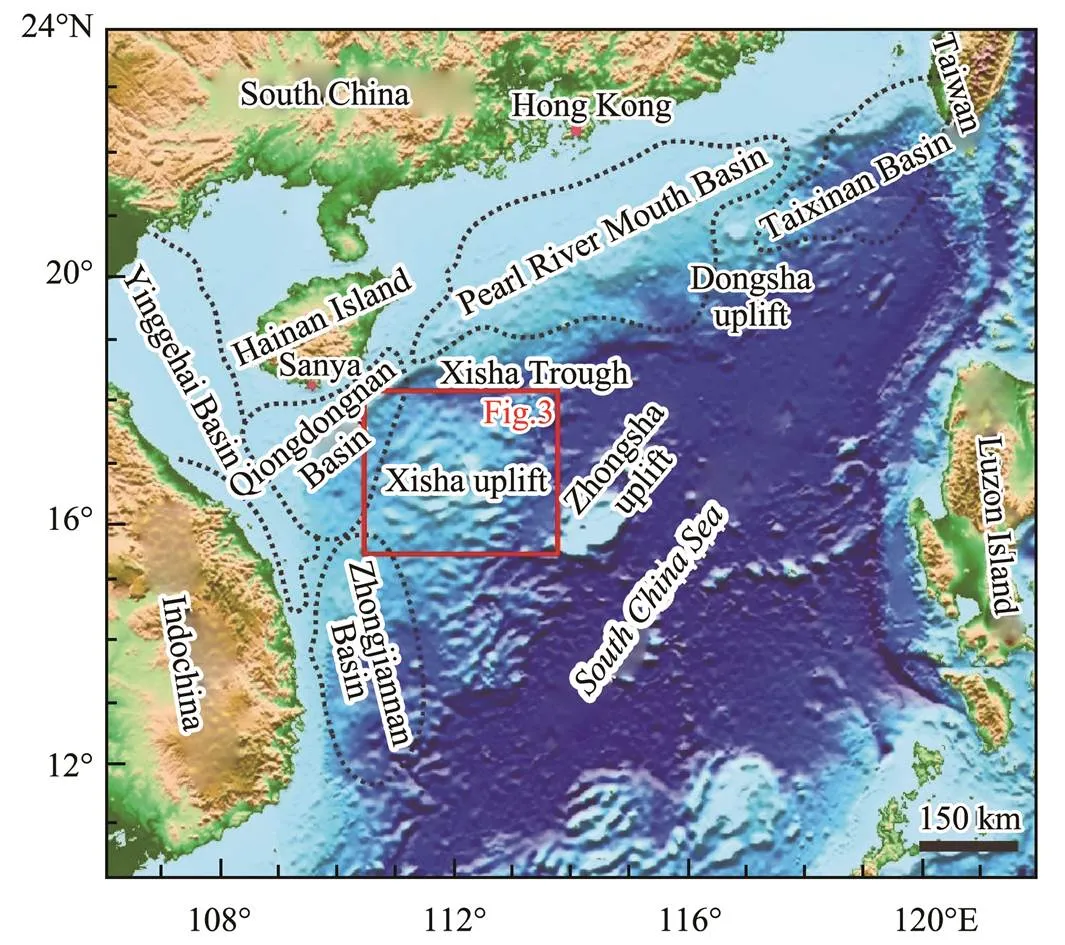
Fig.1 Topographic map of the South China Sea showing the location of the study area in the Xisha uplift with respect to the major topographical features, such as the Zhongsha uplift, the Dongsha uplift, the Xisha Trough, the Qiongdongnan Basin, the Zhongjiannan Basin, the Pearl River Mouth Basin, the Taixinan Basin, and the Yinggehai Basin. The location of this study area is marked in a red box, which outlines the extent of the multibeam bathymetric survey (Fig.3).
The northern part of the SCS is connected to the South China continenta passive continental margin and has a wide shelf area (Wang and Li, 2009; Li., 2014). The study area for the present work is the Xisha area, which is located in the northern SCS and is the transitional area between the continental and oceanic crusts. The Xisha area re-fers to the Xisha uplift, which includes a series of tectonic units, such as the Guangle uplift, northwest submarine sub-basin, and parts of the Qiongdongnan Basin. The SCS has the basic environmental conditions for reef growth, and it has been suggested that the carbonate platform thrived on the Guangle uplift during the early Miocene (Fyhn., 2013). However, the Guangle uplift graduallybecame sub- merged in the late Neogene in response to different regional subsidences (Wang., 2013, 2016). Sincethe early Neogene, carbonate platform growth has continued on the Xisha uplift. The tectonic evolution of the Xisha area is mainly controlled by that of the SCS. The geophysical data show that the crustal structure of the Xisha Trough is characterized by a thin middle and two thick strata at the north and south sides. It is a typical rifting valley formed by the strong tectonic events of the northern SCS on the northern continental margin (Liu and Wu, 2006). Prior to the Miocene, most of the Xisha uplift that was above sea level experienced severe erosion, thus beingunable to generate deposition. Beginning in early Miocene, the Xisha uplift began to settle and the hemipelagic sediment environment began to expand with the continuous expansion of the central sea basin.
3 Data and Methodology
The bathymetric data used in this study were provided by the Hainan Institute of Marine Geology Survey and the Institute of Deep-Sea Science and Engineering, the Chinese Academy of Science. The two-dimensional (2D) seismic profiles provided by the Hainan Institute of Marine Geo- logy Survey contain only seismic profiles across the area around the Xuande Atoll. The resolution of the bathymetricdata is 100m, while that of the seismic data is 25m, which is sufficient to identify an MTD greater than approxima- tely 1km2.
In this study, most of the acquired data are bathymetric data, and only some seismic data around Xuande and Yong-le Atolls are available. Therefore, the identification ofthe MTDs is mainly based on the geomorphology and slope of the seafloor (Fig.2A). On the basis of this approach, MTDs were mainly identified by the following characteristics: 1) MTDs formed steep headscarps and sidewalls at the head area and two sides, as observed on the seafloor slope map; 2) seafloor geomorphology turned into a bump after a slump, failure, or gravity flow, and the MTDs formed folds, pressure ridges, and thrust faults as a result of squeezing sediment. These characteristics are significantly different from those of the original gentle seafloor. To verify the feasibi- lity of this method, we used the seismicdata around the Xuande Atoll as a supplementary data source, and we found that our results were reliable. Although this method satisfied the morphological parameter statistics, certain li- mitations remain: 1) The bathymetric data have a limited resolution, which may cause small MTDs to remain unidentified. 2) The sediments of the MTD toe generally evolve into turbidity currents or slip into the submarine canyon and channel. Thus, the estimated range may be smaller than the true range. 3) Some MTDs under the impact of gra- vity flows make the features of the head cliff difficult to identify using the bathymetric data. 4) The main data used for MTD identification are the bathymetric data, which show only the latest MTDs on the surface of the seafloor and not earlier MTDs.
A total of 32 MTDs were identified using the bathymetric data (Fig.3A) and the 2D seismic profiles in the Xisha uplift, which is a typical carbonate environment. Wethen analyzed the morphometric characteristics of the MTDs and compared them with those that developed in the continental margin by using data from previous studies (Mc- Adoo., 2000; Moscardelli and Wood, 2015).
Once the MTDs were delineated, the geomorphologic parameters, including area, headscarp water depth, headscarp height, headscarp slope, scar slope, local unfailed slope,and runout distance, were measured using Global Mapper?.These geomorphologic parameters, combined with the par-tial seismic profiles, were used to investigate the origin and distribution of the MTDs. The area (A) of an MTD was directly measured by Global Mapper?. We estimated the volume () of an MTD by assuming an approximate wedge-shaped geometry model as follows (McAdoo., 2000):
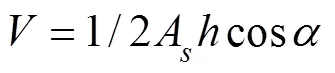
whereAis the MTD area,is the headscarp height, andis the surface slope (Fig.2B).
Fig.2 A) Schematic of the main geomorphologic elements and recognition criteria of an MTD from the bathymetry maps in this study area. B) Schematic illustration of an MTD by assuming an approximate wedge-shaped geometry model showing the volume was calculated using three parameters of MTD, namely, area, headscarp height, and scar slope from bathymetry maps. The volume is the area of MTD multiplied by the headscarp height and then divided by two (McAdoo et al., 2000).
The calculated volume of the MTD using this method is smaller than the true volume because the true volume should be the sum of the volume of the residual failed ma-terials, the volume lost by shear compaction during failed sediment emplacement, and the turbidite volume (evolvingfrom failed materials) (Sun., 2018). However, this limitation cannot be completely eliminated and is within acceptable limits. We also analyzed the correlation between the MTD parameters (Table 1). When Pearson’s correlation coefficient was greater than 0.5, the parameters were considered significantly correlated (Profillidis and Botzoris, 2019; Table 2).
4 Results
4.1 Morphological Parameter Statistics of MTDs in the Xisha Area
We identified 32 MTDs in the Xisha area by using the standard method and the proposed method. The bathyme- tric data were used to investigate the correlations between architectural and morphological parameters of MTDs, as summarized in Table 1. The obtained MTD measurements, including area, water depth, runout distance, scar slope, lo- cal unfailed slope, headscarp height, volume, and the ratio of headscarp height to runout distance (), arelisted inTable 2.
4.1.1 Water depth and distribution
We used the minimum water depth of the headscarp to represent the initial location of the MTDs. As summarized in Table 2, most of the MTDs were distributed over the slope of the carbonate platform at water depths of 30–2000m, with a mean depth of 837m. In the Xisha area, the MTDsmainly occurred at water depths of 400–1000m (27 MTDs in total). Fewer MTDs had water depths less than 400m and more than 1000m (Fig.4A). Twenty-five of the 32 MTDs were distributed on the north side of the atolls and on the side near the central part of the Xisha uplift, while the rest of the MTDs occurred on the east and south sides of the atolls (Fig.3B).
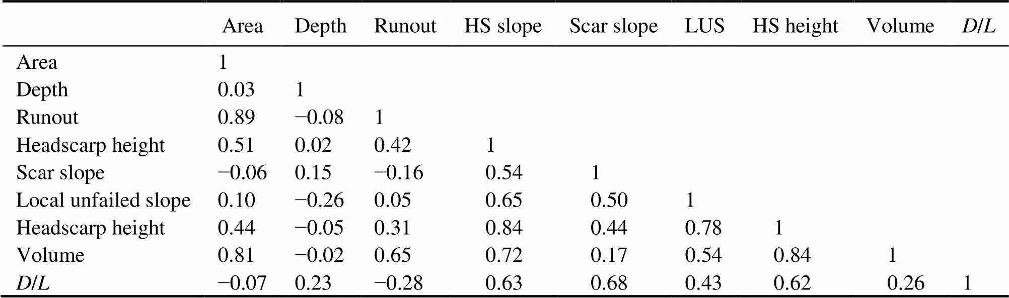
Table 1 Correlation coefficients between the morphologic parameters for the MTDs
Notes: Depth, water depth of headscarp; Runout, runout distance; HS, headscarp; LUS, local unfailed slope;/, headscarp height to runout distance.

Table 2 MTD statistics summary of measured parameters. The listed values are the mean of numerous individual measurements
()
()
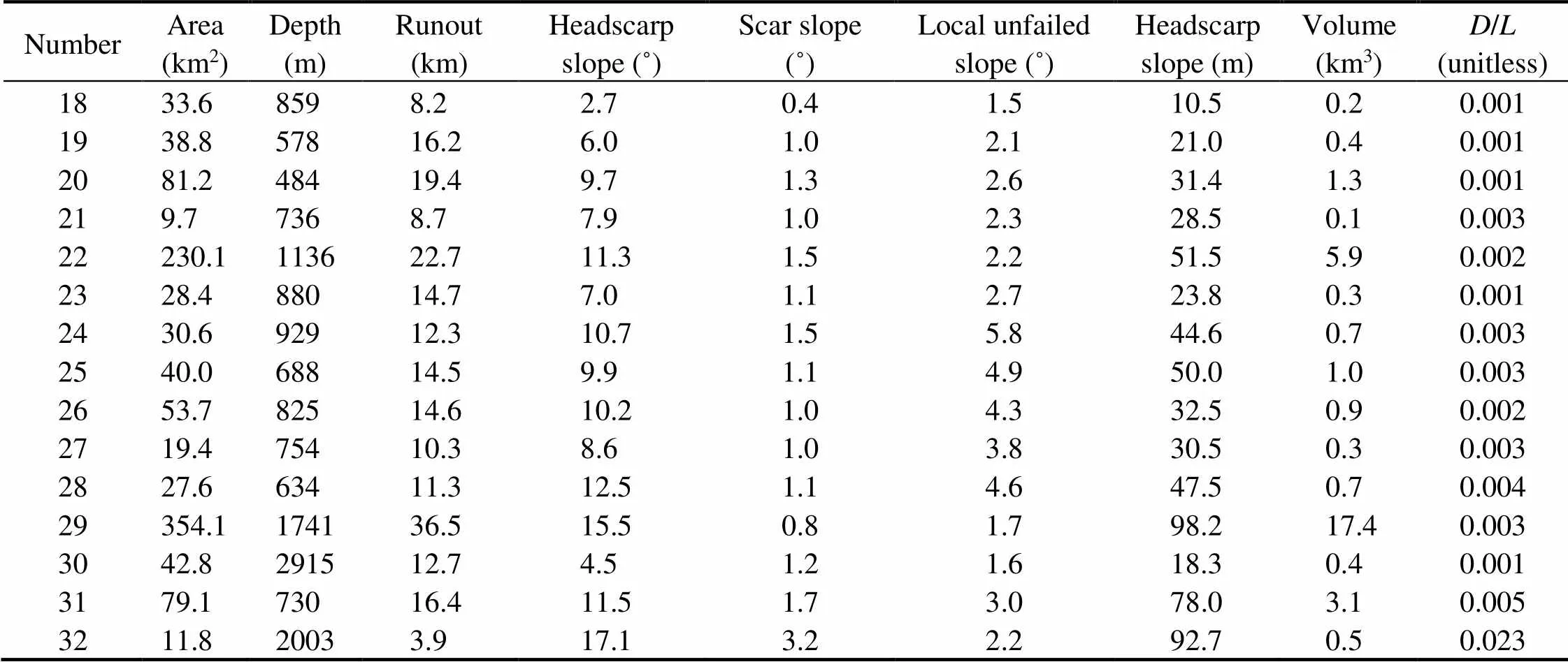
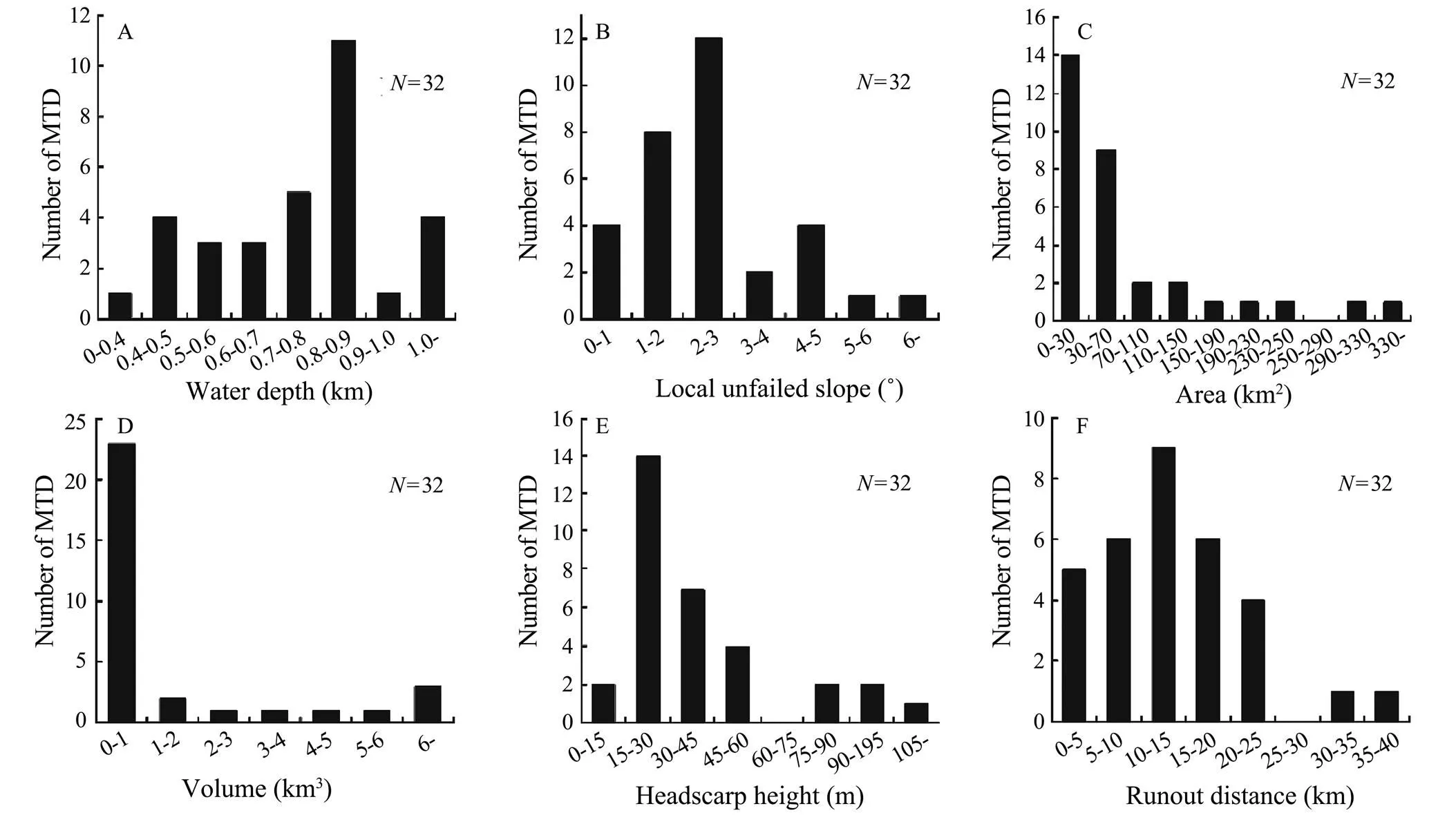
Fig.4 Morphometric parameters for MTDs in this study area.
4.1.2 Local unfailed slope
We used the local unfailed slope to represent the original slope of the seafloor. As shown in Fig.4B, the MTDs inthe Xisha area were mainly distributed on slopes with gradients that vary from 0.5? to 5? (28 in total) and rarely developed on slopes with a gradient less than 0.5? or greater than 5?.
4.1.3 Area and volume
The largest MTD is approximately 354.1km2and is lo- cated on the north side of Xuande Atoll, which is near the Xisha Trough. Most of the MTD areas were smaller than 50km2–one is smaller than 5km2, nine are between 50 and 100km2, and only two are larger than 250km2. The MTD located on the slope of Xuande Atoll is one of only two MTDs with an area greater than 250km2in the Xisha area. Overall, the total area of the MTDs is 2225.2km2(Fig.4C).
The total volume of the MTDs is 76.7km3, but the average volume is only 2.3km3. The most striking observation to emerge from the data was that the volumes of 22MTDs were smaller than 1km3. Furthermore, seven MTDs had volumes between 1 and 6km3, and three were larger than 6km3. The MTD with the smallest volume was approximately 0.1km3(Fig.4D).
4.1.4 Headscarp heights and runout distances
The height of the headscarp on the slope of the carbonate platform in the study area rarely exceeded 55m. Of the 32 MTDs measured, only four had headscarp heights between 75 and 100m, and only one reached more than 100m (Fig.4E).
The majority of the MTDs in this study had runout distances of less than 25km, with the exception of two MTDs, which exceeded 25km (Fig.4F). Large sediment transport conduits, such as deep-water channels and submarine can-yons, are widely developed in the study area. Most of these conduits connect with the slope of the carbonate platform by the head while the tail interacts with the deeper basin. The MTDs that occur on the platform slope merge into these large sediment transport conduits even further into the deep-sea basin. Therefore, the maximum transport distance of the MTDs measured in this study may not reflect their true transportability, which may be farther than that found in this work.
4.2 MTDs on the Slope of the Xuande Platform
Seven MTDs were mapped on the slope of the Xuande platform. The No.1 MTD had the largest area (306.3km2). The No.6 MTD, which occurred on the east side of theXuande platform, had the largest volume (20.4km3), a head-scarp height of 267.4m at water depths ranging from 100m to 1600m (Table 1), a runout distance of 17.23km, and a maximum width of approximately 14.51km. The slope properties of the No.6 MTD show that most of its area has a scar slope of less than 15?, while the headscarp and sidewall slopes exceed 15? (Fig.5B). The toe of the MTD is connected with the Sansha canyon (Li., 2017), which formed as a result of landslides in which MTD sediments were transported to the canyon rather than undergoing classical compression.
The seismic stratigraphy of the No.6 MTD was divided into four seismic units (units 1, 2, 3, and 4 from top to bot-tom), which are bound by R0, R1, and R2 (Fig.6). These units were separated based on differences in their internal reflection configurations. We could not identify the age of the boundary layer due to a lack of borehole data. Unit 1 is bound by seismic horizon R0 at its base, while its top is connected to the seafloor. In the upper slope region, unit 1 exhibits chaotic moderate-amplitude reflections, which may be landslides that occurred during a later period (Fig.6B). The downslope exhibits continuous high-amplitude reflec-tions, suggesting the presence of hemipelagic sediments (Fig.6B). Unit 2 is bound by the seismic horizon R1 at the bottom R0 at its top and shows the predominance of mo- derate-amplitude reflections (Figs.6A and 6B). This unit is interpreted as MTDs that occurred in an earlier period. In addition, a sliding surface was discovered in unit 2. Mean-while, unit 3 is bound by seismic horizons R1 and R2, which may be normal deep-sea sediments. A concave characte- ristic in the strata downslope of the seismic horizon R2 suggests that submarine canyons existed before the MTDs occurred (Fig.6B).
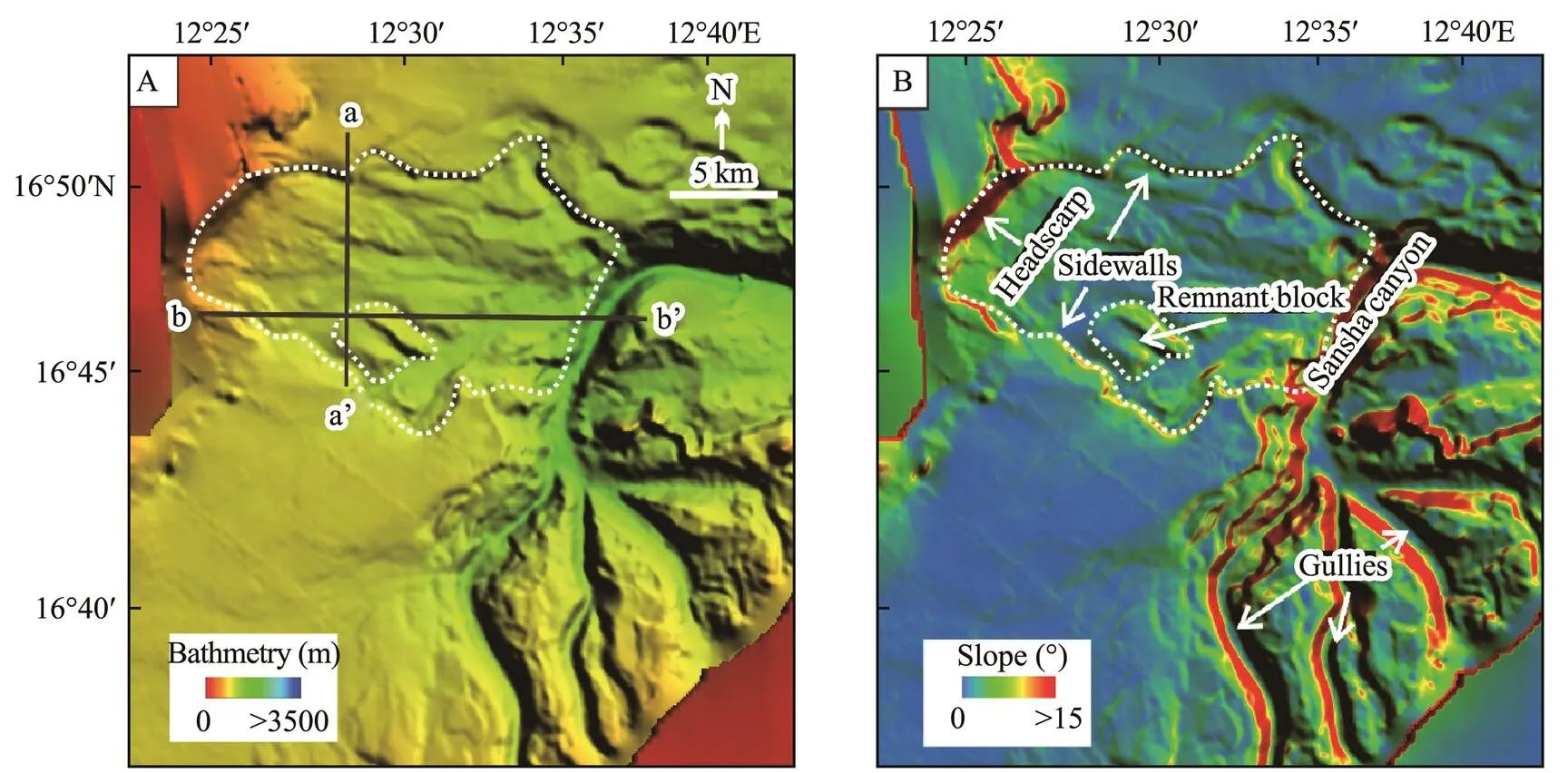
Fig.5 (A) Bathymetry of the study area showing the relationship between No.6 MTD and the Sansha canyon as well as gullies. The two black lines indicate the seismic profiles shown in Fig.6. (B) Slope gradient map.
4.3 Sediment Conduits in the Xisha Area
Many gullies were observed at different locations around the carbonate platform, including the south slope of the Xuande platform, the northwest slope of the Yongle Atoll, and the north slope of the Dongdao platform. These gullies are observable on the bathymetric map, with lengths varying from 6km to 20km, and they likely formed as a result of the gravity flows scouring the carbonate platform.Some gullies connect with the submarine canyon by the toe, acting as sediment conduits for the transportation of carbonate sediment from the top of the carbonate platform to the submarine canyon.
Numerous submarine channels were observed on the bathymetric map, revealing various morphologies that us- ually connect with the toe of the MTDs in the upper region The MTD sediments disintegrated into turbidity currents and were injected into the submarine channels, scouring the channels and thereby maintaining their shape. Some channels are connected not only with the MTDs near the upper region but also with submarine canyons, deep-water basins, and troughs near the downslope region. The MTD sediments are transported into submarine canyons or deep-water basins through these sediment conduits.For example, the channel located north of the No.2 MTD has a length of approximately 77km and a width of 1–5km, and it has a connection between its upper region and the toe of the No.2 MTD, while its downslope region con- nects to the Xisha Trough (Figs.3 and 8).
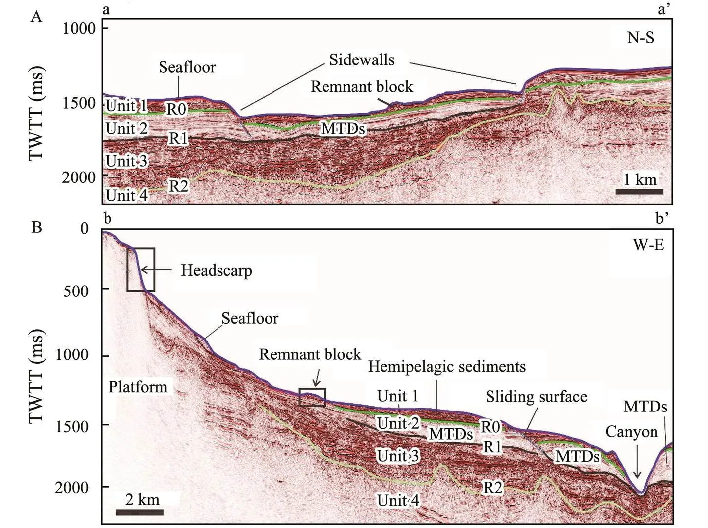
Fig.6 Seismic profiles along No.6 MTD (see Fig.5A for location) strike (b–b’) and dip (a–a’) showing typical stratal rela- tionships within the studied MTD. Four seismic units (units 1, 2, 3, 4) were bounded by three boundary layers (R0, 1, 2).
In addition, submarine canyons have been widely observed in the study area, the largest of which is the Sansha canyon, which is located on the east side of the Xuande platform and is approximately 115km long. The upper part of the Sansha canyon connects to a gully of the Dong- dao platform and coincides with the toe of the No.6 MTD (Fig.5). The downslope of the Sansha canyon is connected to the northwest sea basin (Fig.3). Similarly, a larger sub- marine canyon located approximately 25km southeast of the Dongdao platform is connected to submarine channels formed by contour currents from the upper region (Ma., 2021), with the downslope being connected to the Zhongsha Trough (Figs.3 and 9).
5 Discussion
In this section, we discuss the correlation of the MTD parameters. Then, we describe the differences in MTDs in different settings. Next, we examine the relationships among MTDs, gullies, channels, and submarine canyons. Finally, we propose a novel carbonate MTD development model.
5.1 Morphometric Correlation Analysis of MTDs
We analyzed the correlation of MTD parameters in the Xisha area to identify their development factors and further evaluate the developmental characteristics of MTDs in a carbonate setting.
A literature survey indicated that the slope and type of MTDs are the most important factors that affect the morphology and distribution of MTDs. In this study, we used the local unfailed slope to represent the original carbonate slope (McAdoo., 2000). Regarding slope, a previous study showed that a lower slope and proximal seafloor may influence the number of MTDs (Hühnerbach and Masson, 2004), even in our study area. According to our statistics, most MTDs in our study area are located on the carbonate slope, where the slope generally ranges from 0? to 5? and where the maximum slope is 30? (Table 2). The slope also influences the morphology of landslides. As summarized in Table 1, the MTD volume is significantly correlated with slope. In particular, a steep slope corresponds to a large MTD volume. In addition, a high correlation exists between the slope, scar slope, and head height. As the scar slope is commonly less than the slope, the MTDs may be dominated by sedimentation.
The MTD type also significantly influences the morpho- logy of the MTDs, which includes its slides, slumps, and debris flows. MTDs caused by slumps and debris flows have relatively rheological behaviors. The parameters that predict these rheological behaviors include headscarp height, headscarp slope, and runout distance. As previously mentioned, stronger or well-consolidated sediments favor the production of steeper and higher headscarps in siliciclastic settings (Adams and Kenter, 2013). Although most of the sediment herein is carbonate debris with high cementation, the assumption that early cementation caused carbonate slope steepness is incorrect (Adams and Kenter, 2013). In the present work, the headscarp heights range from 75m to 100m, which is relatively smaller than that of landslides on open slopes. These findings are consistent with similar headscarp features in other carbonate slopes, such as the large-scale carbonate submarine mass-wasting along the northwestern slope of the Great Bahama Bank (Principaud., 2015).
5.2 Comparison with MTD Parameters from Siliciclastic Settings
Numerous carbonate MTDs have been discovered so farin the Xisha area of the SCS. To further understand MTDs,we must compare MTDs from different settings. The find-ings of this work provide novel insights into the development model and morphological characteristics of MTDs in carbonate settings. Table 3 summarizes several global MTD studies that quantitatively describe and discuss the common characteristics of MTDs and their settings.
To predict the rheology of the mass-wasting during failure, we used the ratio of headscarp height to runout distance (/) and runout distance. Strong MTD rheological beha- vior corresponds to small/and large runout distance (McAdoo., 2000; Green and Uken, 2008; He., 2014). Both parameters were applied to open-slope and submarine canyon landslides. The runout distances are re- latively less than those of giant landslides at less than 25km. However, the/ratio is extremely small, with a mean of 0.003 (Table 2), which is significantly less than that of the US continental slope, which is 0.02, and far less than that of the submarine canyon at the northern continental slope in the SCS, which is 0.05 (McAdoo., 2000; He., 2014). A review of the literature on several submarine landslides suggests that a range of/ratios occurs. In general, the ratios are 0.1 for slumps and 0.002 for flows(Hampton., 1996). In the US continental slope, the ratios are 0.02 for slumps and 0.015 for blocky slides, and disintegrative slides have a/ratio of 0.002 (McAdoo., 2000). We propose that the MTDs in our study area are strongly rheological likely a result of post-landslide cohesion loss of sediment that is possibly formed by disintegrative slides or debris flows.

Table 3 Summary of morphological parameters for MTDs described in previous studies
With regard to the MTD scale, previous studies suggest- ed that the scale is larger for open slope-sourced MTDs than for the canyon-sourced MTDs (Chaytor., 2009; Twichell., 2009). As listed in Table 3, smaller MTDs also have a tendency to generally occur in confined conditions, which may stifle their scale,., the northern Kwa-Zulu-Natal continental shelf and northern continental slope of the SCS (Green and Uken, 2008; He., 2014). The process of gliding in canyon-associated settings is easily impeded by geomorphological features, such as submarine canyon walls (He., 2014), which is why MTDs under unconfined conditions are generally larger, especially in passive continental slopes, such as the US continental slope (McAdoo., 2000). The MTDs on the carbonate slope in this study are larger than canyon-sourced MTDs but smaller than those on the continental slope. Another MTD scale control factor is sediment source.MTDs generally cover larger areas on the seafloor where the slopes of the continental shelf are impacted by larger river systems or glaciers (Twichell., 2009). Higher sedimentation rates and shallow stratigraphy have strong impacts on the scale of MTDs on the continental slope (Twichell., 2009). However, carbonate sediments are produced essentially, making their sedimentation rates lower than those of the continental slope because higher sedimen- tation rates in the passive siliciclastic margin are driven by climate changes between glacial and interglacial periods(Dunbar., 2000; Page., 2003). Meanwhile, most canyon-sourced MTDs are located away from large sediment sources, such as river systems and salt diapirs (Twi- chell., 2009; He., 2014).
Another significant difference between these MTDs is the original slope. The other carbonate slope MTDs have similar original slopes, ranging from 0? to 5?, to those foundin this study (Mullins., 1986;Correa., 2012). Con-versely, MTDs in the continental slope are commonly located at slopes with a mean of 1.38?. The steepest original slopes are the canyon-sourced MTDs. Thus, a possibility is that a steep original slope corresponds to a small MTD.
The surface gradients of some MTDs developed on passive continental margins and in canyons are less than and greater than those of the original seafloor slope, respectively. Thus, the transport process of MTDs to the down- slope may either excavate the original slope, thus making it steeper, or accumulate on the downslope, thus making it gentler. Therefore, the gentle surface slopes that were found may have been caused by deposition in the transport of the MTDs. However, many MTDs in the carbonate setting also eroded the original seafloor, such as those along the slope of the Great Bahama Bank, which are derived from the collapse of mass-wasting of the carbonate bank slope (Mulder., 2012).
5.3 Relationship Between Sediment Conduits and MTDs
Sediment transport conduits of different scales, such as deep-water submarine canyons, gullies, and channels, de- velop on the carbonate platform slope (Fig.3B). These con- duits connect with the carbonate platform slope in the upper region and connect with deep-water basins in a down- slope direction. These sediment conduits, which reach lengths of more than 10km, were extracted quantitatively using geomorphologic analysis software (Fig.3B). The re- sults suggest that MTDs are generally connected to the head of a large sediment transport conduit in the study area by their toe. Moreover, larger MTDs occurred on carbonate platform slopes that connected to submarine canyons, such as the No.6 MTD, which connected to the head of the Sansha submarine canyon.A similar scenario occurred in the northern SCS, where three large-scale MTDs on the northern slope of the Xisha Trough were filled by turbiditycurrents derived from MTD sediments(Wang., 2018b). In addition, gullies and channels are observed on the carbonate slope (Figs.5, 7–9), which commonly form gravity flows that have erosional and depositional aspects (Pratson., 2000; Lee., 2002). Gravity flows denote active sediment transfer and plunging in the upper slope (Wilson and Roberts, 1992, 1995). The sediment from the top of the carbonate platform is transportedgravity flows and accumulates on the downslope as MTD material sources, most of which would generate gravity flows that flow through channels and canyons. These canyons and channels subsequently connect to the deep-water basin.
These findings provide critical information regarding the relationship between sediment conduits and MTDs. We propose that a positive correlation may exist between se- diment conduits and MTDs in the study area. On the one hand, carbonate debris on the top of a carbonate platform can generate gravity flows under the influence of tides, waves, monsoon, and ocean currents; these gravity flows then form gullies and channels on the carbonate slopeerosion (Fig.10A). Fall-out and convective sedimentation are generated during associated sediment transport along the slope, indicating that a decrease in the slope gradient probably caused the gradual transition from erosion to de- position. Eventually, slope instability and submarine land- slides occur as a result of sediment accumulation at the toe of the slope. On the other hand, gravity flows associatedwith gravity flows and MTDs on carbonate slopes provide carbonate debris from the top of the platform to sediment conduits. Meanwhile, gravity flows scour gullies, channels, and submarine canyons to maintain their shape.
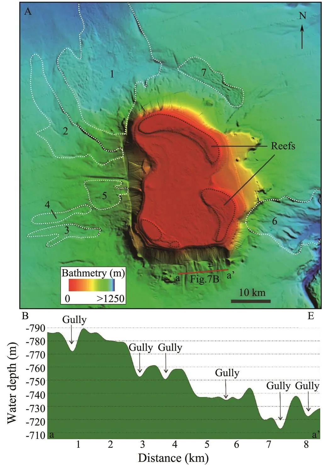
Fig.7 (A) Multibeam bathymetric map showing the detailed morphology of Xuande Atoll, with seven MTDs andsome gullies developed on the slope. (B) Bathymetric profile crossing the downslope region of the north slope of Xuande Atoll and revealing the presence of gullies.
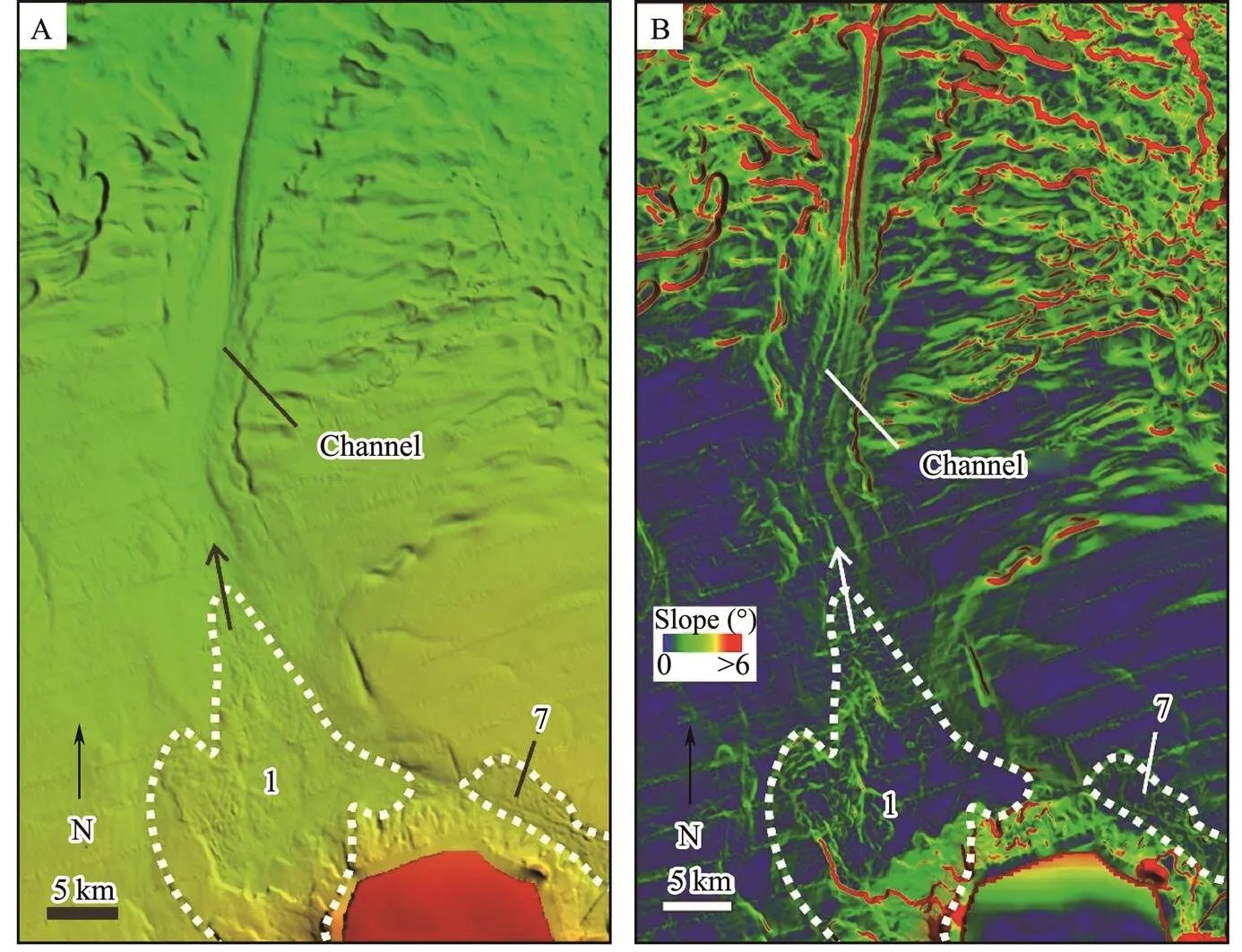
Fig.8 Toe of No.1 MTD connected with a submarine channel, suggesting that sediments from MTDs are injected into the channel. (A) Multibeam bathymetric map showing the detailed seafloor morphology of submarine channels and Nos.1 and 7 MTDs. (B) Slope map showing the boundaries of channel and MTDs.
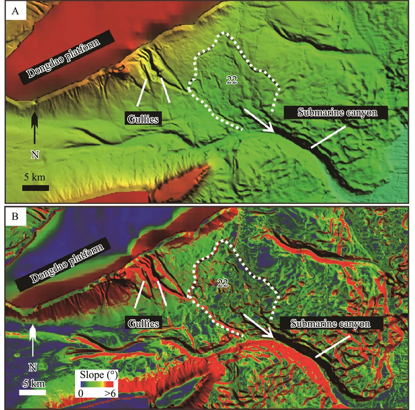
Fig.9 Toes of gullies connected with No.22 MTDs in the Dongdao platform slope. The toe of No.22 MTDs coincides with the boundary of the submarine canyon. (A) Multibeam bathymetric map showing the close relations among gullies, MTDs, and the submarine canyon. (B) Slope map showing the boundaries of gullies, MTDs, and the submarine canyon.
5.4 Development Pattern of MTDs in the Xisha Area
On the basis of our results, we proposed the following new conceptual MTD development pattern for the Xisha area. First, reef-building organisms generally begin to grow on the top of the carbonate platform margin because of certain parameters, such as tectonic activity, sea level, and monsoon. Then, a giant wave formed by a storm event, such as a typhoon, destroys the reef, producing carbonate sediment that disintegrates into carbonate debris. Under the influence of tides and other factors, some of the carbonate debris are transported into a lagoon (Fig.10A). How-ever, in the second stage, most of these carbonate debris are transported downslope in the form of suspended particles or gravity flows (., gravity flows or turbidity cur- rents), which then accumulate on the slope as a sediment source. Meanwhile, gravity flows initiate gullies and chan-nels in the carbonate slope. Thus, many gullies and channels appear on the downslope, providing evidence of scour- ing caused by gravity flows. In general, the upper part of the slope is steep because it was mainly formed by carbonate cementation that is producedin the early stage. Meanwhile, modern carbonate sediment is principally distributed in areas with a gentle gradient, commonlynear the middle and downslope (Fig.10B). Therefore, in the study area, the MTDs are mainly distributed on the slope with a gradient ranging from 0? to 5?.
In the third stage, the gravity flows that arrive at the large channel or submarine canyon turn into turbidity cur- rents (Fig.10C). Note that interacting gravity flows and seafloor roughness alter channel initiations and shapes. The MTD slope sediments are evacuated, transported, and disintegrated downslope to form loose material within the submarine canyons or channels, where some of the sediment is transported to the deep-sea basin (Fig.10C).
6 Conclusions
In this study, acquired high-resolution bathymetric data and seismic data enabled us to identify and measure the morphology of MTDs, analyze their morphological para- meter correlations, examine their variation based on setting, and determine their relationship with sediment conduits. On the basis of these findings, we proposed a new MTD development pattern for the Xisha area. The main conclusions are as follows:
1) Thirty-two MTDs on the carbonate platform slope in the Xisha area of the northern SCS were identified using high-resolution bathymetric data. The MTDs are mainly distributed on the carbonate slope, ranging from 0.5? to 5?, with water headscarp depths of 400–1000m, and a total area and volume of 2225.2km2and 76.7km3, respectively.
2) Most of the MTDs in the study area are distributed on slopes less than 5? and belong to small-scale MTDs thatare distinguished from other areas. This feature can be attri- buted to differences in the sediment sources and deposition processes. The main reasons for these differences include the MTD sediment consisting of carbonate grains that form, carbonate sediment with higher cementation, and stronger or well-consolidated carbonate sediment.
3) The toes of the carbonate slopes favor the accumula- tion of thick layers of incompletely cemented carbonate debris. Such accumulation can cause failure events that areeasily triggered by earthquakes or storms. While transport-ed along the slope, carbonate debris scours the seafloor, forming gullies and channels on the slope. The failed MTD sediment disintegrates and evolves into gravity flows that flow into sediment conduits, such as submarine canyons.

Fig.10 Conceptual model showing the evolution of MTDs in the isolated carbonate platform in this study area. (A) Stage 1: reef-building organism growth serves as the source of carbonate debris and the presence of tides on the top of the carbonate platform. (B) Stage 2: gravity flows result in giant waves or storms, and those currents scar the carbo- nate slope and form gullies. (C) Stage 3: MTDs are triggered by external factors such as earthquakes, disintegrated into gravity flows, and then injected into submarine canyons and channels.
This study is the first to provide a new understanding of the characteristics and development of MTDs in carbonate settings. However, this research is limited by the lack of seismic data and limited samples. Nevertheless, the findings will serve as a basis for future research.
Acknowledgements
This work was supported by the Key Research and De- velopment Program of Hainan Province (No. ZDYF2020 209), the National Natural Science Foundation of China (No. 42176083), and the Key-Area Research and Deve- lopment Program of Guangdong Province (No. 2020B111 1020002).
Adams, E. W., Kenter, J. A., Verwer, K., Playton, T., and Harris, P., 2013. So different, yet so similar: Comparing and contrasting siliciclastic and carbonate slopes: Deposits, architecture, and controls of carbonate margin, slope, and basinal settings., 105: 14-25.
Bachtel, S. L., Kissling, R. D., Martono, D., Rahardjanto, S. P., and MacDonald, B. A., 2004. Seismic stratigraphic evolution of the Miocene–Pliocene segitiga platform, East Natuna Sea, Indonesia: The origin, growth, and demise of an isolated carbonate platform., 81: 309-328.
Boe, R., Proschdanielsen, L., Lepland, A., Harbitz, C. B., Gauer,P., Lovholt, F.,., 2007. An early Holocene submarine slide in Boknafjorden and the effect of a slide-triggered tsunami on Stone age settlements at Rennes?y, SW Norway., 243 (1): 157-168.
Chaytor, J. D., ten Brink, U. S., Solow, A. R., and Andrews, B. D., 2009. Size distribution of submarine landslides along the U.S. Atlantic margin., 264 (1-2): 16-27.
Correa, T. B. S., Eberli, G. P., Grasmueck. M., Reed, J. K., and Correa, A. M. S., 2012. Genesis and morphology of cold-water coral ridges in a unidirectional current regime., 326: 14-27.
Counts, J. W., Jorry, S. J., Leroux, E., Miramontes, E., and Jouet, G., 2018. Sedimentation adjacent to atolls and volcano-cored carbonate platforms in the Mozambique Channel (SW Indian Ocean)., 404: 41-59.
Dong, Y., Wang, D., and Cui, L., 2019. Assessment of depth ave- raged method in analysing runout of submarine landslide.,17: 543-555.
Dong, Y., Wang, D., and Randolph, M., 2017. Investigation of im- pact forces on pipeline by submarine landslide with material point method., 146 (1): 21-28.
Dunbar, G. B., Dickens, G. R., and Carter, R. M., 2000. Sediment flux across the Great Barrier Reef shelf to the Queensland Trough over the last 300ky., 133 (1-2): 49-92.
Embley, R. W., 1980. The role of mass transport in the distribution and character of deep-ocean sediments with special re- ference to the North Atlantic., 38 (1): 23-50.
Fyhn, M. B. W., Boldreel, L. O., Nielsen, L. H., Giang, T. C., and Abatzis, I., 2013. Carbonate platform growth and demise offshore central Vietnam: Effects of early Miocene transgression and subsequent onshore uplift., 76 (20): 152-168.
Green, A., and Uken, R., 2008. Submarine landsliding and canyon evolution on the northern KwaZulu-Natal continental shelf, South Africa, SW Indian Ocean., 254 (3-4): 152-170.
Hampton, M. A., Lee, H. J., and Locat, J., 1996. Submarine landslides., 34 (1): 33-59.
He, Y., Zhong, G., Wang, L., and Kuang, Z., 2014. Characteristics and occurrence of submarine canyon-associated landslides in the middle of the northern continental slope, South China Sea., 57: 546-560.
Hühnerbach, V., and Masson, D. G., 2004. Landslides in the NorthAtlantic and its adjacent seas: An analysis of their morphology, setting and behaviour., 213 (1-4): 343-362.
Lee, S. E., Talling, P. J., Ernst, G. G. J., and Hogg, A. J., 2002. Occurrence and origin of submarine plunge pools at the base of the US continental slope., 185 (3): 363-377.
Li, C., Xu, X., Lin, J., Sun, Z., Zhu, J., Yao, Y.,., 2014. Ages and magnetic structures of the South China Sea constrain- ed by deep tow magnetic surveys and IODP Expedition 349., 15 (12): 4958-4983.
Li, X. J., Wang, D., Wu, S., Wang, W., and Liu, G., 2017. Geomorphology of Sansha canyon: Identification and implication., 3 (37): 28-36 (in Chi- nese with English abstract).
Liu, F. L., and Wu, L. S., 2006. Topographic and morphologic characteristics and genesis analysis of Xisha Trough sea area in the South China Sea.,3 (26): 7-14 (in Chinese with English abstract).
Ma, B. J., Qin, Z., Wu, S., Cai, G., Li, X., Wang, B.,., 2021. High-resolution acoustic data revealing periplatform sedimentary characteristics in the Xisha Archipelago, South China Sea., 9 (12): 1-15.
McAdoo, B. G., Pratson, L. F., and Orange, D. L., 2000. Submarine landslide geomorphology, US continental slope.,169 (1): 103-136.
Moscardelli, L., and Wood, L., 2015. Morphometry of mass-trans- port deposits as a predictive tool., 128 (1): 47-80.
Moscardelli, L., Wood, L. J., and Mann, P., 2006. Mass-transport complexes and associated processes in the offshore area of Trinidad and Venezuela., 90 (7): 1059-1088.
Mulder, T., Ducassou, E., Eberli, G. P., Hanquiez, V., Gonthier, E., Kindler, P.,., 2012. New insights into the morphology and sedimentary processes along the western slope of Great Bahama Bank., 40 (7): 603-606.
Mullins, H. T., Dolan, J. F., Breen, N. A., Andersen, B., Gaylord, M., Petruccione, J. L.,., 1991. Retreat of carbonate platforms: Response to tectonic processes., 19 (11): 1089- 1092.
Mullins, H. T., Gardulski, A. F., and Mine, A. C., 1986. Catastro- phic collapse of the west Florida carbonate platform margin., 14 (2): 167-170.
Page, M. C., Dickens, G. R., and Dunbar, G. B., 2003. Tropical view of Quaternary sequence stratigraphy: Siliciclastic accumu- lation on slopes east of the Great Barrier Reef since the Last Glacial Maximum., 31 (11): 1013-1016.
Pautot, G., Rangin, C., Briais, A., Tapponnier, P., Beuzart, P., Lericolais, G.,., 1986. Spreading direction in the central South China Sea., 321 (6066): 150-154.
Pope, E. L., Tailing, P. J., and Carter, L., 2017. Which earthquakes trigger damaging submarine mass movements: Insights from a global record of submarine cable breaks?, 384: 131-146.
Pratson, L. F., Imran, J., Parker, G., Syvitski, J. P. M., and Hutton,E., 2000. Debris flows. turbidity currents: A modeling comparison of their dynamics and deposits., 72 (68): 57-71.
Principaud, M., Mulder, T., Gillet, H., and Borgomano, J., 2015. Large-scale carbonate submarine mass-wasting along the north-western slope of the Great Bahama Bank (Bahamas): Morpho-logy, architecture, and mechanisms., 317: 27-42.
Profillidis, V. A., and Botzoris, G. N., 2019. Chapter 5–Statistical methods for transport demand modeling. In:–. Elsevier, Amsterdam, 163-224.
Ru, K., and Pigott, J. D., 1986. Episodic rifting and subsidence in the South China Sea., 70 (9): 1136-1155.
Sibuet, J. C., and Hsu, S. K., 1997. Geodynamics of Taiwan arc- arc collision., 274 (1): 221-251.
Sun, Q., Alves, T., Lu, X., Chen, C., and Xie, X., 2018. True volumes of slope failure estimated from a Quaternary mass- transport deposit in the northern South China Sea., 45 (6): 2642-2651.
Tappin, D. R., Grilli, S. T., Harris, J. C., Geller, R. J., Masterlark, T., Kirby, J. T.,., 2014. Did a submarine landslide contri- bute to the 2011 Tohoku tsunami?, 357: 344- 361.
Tappin, D. R., Watts, P., Mcmurtry, G. M., Lafoy, Y., and Matsumoto, T., 2001. The Sissano, Papua New Guinea tsunami of July 1998–offshore evidence on the source mechanism., 175 (1): 1-23.
Taylor, B., and Hayes, D. E., 1980. The tectonic evolution of the South China Basin. In:. Hayes, D. E., ed., American Geophysical Union, Washington, D. C., 89-104.
Twichell, D. C., Chaytor, J. D., ten Brink, U. S., and Buczkowski,B., 2009. Morphology of late Quaternary submarine landslides along the U.S. Atlantic continental margin., 264 (1-2): 4-15.
Wang, D., Wu, S., Li, C., and Yao, G., 2016. Submarine slide evidence for late Miocene strike-slip reversal of Red River fault., 59 (11): 2231-2239.
Wang, D., Wu, S., Qin, Z., Spence, G., and Lü, F., 2013. Seismic characteristics of the Huaguang mass transport deposits in the Qiongdongnan Basin, South China Sea: Implications for regional tectonic activity., 346: 165-182.
Wang, D., Zeng, H., Wu, S., Wang, W., Li, Q., and Mi, L., 2018a.Seismic sedimentological evidence for filling process of western central canyon system controlled by the evolution of the Tibetan Plateau and the East Asia monsoon since the late Miocene, South China Sea., 6 (2): 1-34.
Wang, P., and Li, Q., 2009.. Springer, Dordrecht, 497pp.
Wang, W., Wang, D., Wu, S. G., David, V., Zeng, H., Cai, G.,., 2018b. Submarine landslides on the north continental slope of the South China Sea., 17 (1): 83-100.
Wilson, P. A., and Roberts, H. H., 1992. Carbonate-periplatform sedimentation by density flows: A mechanism for rapid off- bank and vertical transport of shallow-water fines., 20 (8): 713-716.
Wilson, P. A., and Roberts, H. H., 1995. Density cascading-off- shelf sediment transport, evidence and impications, Bahama banks., 65 (1): 45-56.
Wu, S., Yang, Z., Wang, D., Lü, F., Ludmann, T., Fulthorpe, C. S.,., 2014. Architecture, development and geological control of the Xisha carbonate platforms, northwestern South China Sea., 350: 71-83.
Xie, X., Müller, R. D., Li, S., Gong, Z., and Steinberger, B., 2006. Origin of anomalous subsidence along the northern South China Sea margin and its relationship to dynamic topography., 23 (7): 745-765.
Yamano, H., Cabioch, G., Pelletier, B., Chevillon, C., Tachikawa, H., Lefevre, J.,., 2015. Modern carbonate sedimentary facies on the outer shelf and slope around New Caledonia., 24 (1): 4-15.
June 17, 2021;
February 10, 2022;
March 7, 2022
? Ocean University of China, Science Press and Springer-Verlag GmbH Germany 2022
. E-mail: wangdawei@idsse.ac.cn
(Edited by Chen Wenwen)
 Journal of Ocean University of China2022年4期
- Journal of Ocean University of China的其它文章
- Complete Mitochondrial Genome of Myra affinis (Decapoda:Brachyura: Leucosiidae) and Its Phylogenetic Implications for Brachyura
- Multisource Target Classification Based on Underwater Channel Cepstral Features
- Joint Model of Wind Speed and Corresponding Direction Based on Wind Rose for Wind Energy Exploitation
- Elastic-Wave Reverse Time Migration Random Boundary-Noise Suppression Based on CycleGAN
- Identification, Phylogeny and Expressional Profiles of Peptidoglycan Recognition Protein (PGRP) Gene Family in Sinonovacula constricta
- Molecular Characterization,Expression Pattern and Transcriptional Regulation of Figla During Gonad Development in Japanese Founder(Paralichthys olivaceus)