
Estimating snow depth or snow water equivalent from space
2022-06-21 12:41:06LiYunDaiTaoChe
LiYun Dai ,Tao Che,2*
1.Key Laboratory of Remote Sensing of Gansu Province,Heihe Remote Sensing Experimental Research Station,Northwest Institute of Eco-Environment and Resources,Chinese Academy of Sciences,Lanzhou,Gansu 730000,China
2.Center for Excellence in Tibetan Plateau Earth Sciences,Chinese Academy of Sciences,Beijing 100101,China
ABSTRACT Satellite remote sensing is widely used to estimate snow depth and snow water equivalent(SWE)which are two key pa‐rameters in global and regional climatic and hydrological systems.Remote sensing techniques for snow depth mainly in‐clude passive microwave remote sensing,Synthetic Aperture Radar(SAR),Interferometric SAR(InSAR)and Lidar.Among them,passive microwave remote sensing is the most efficient way to estimate large scale snow depth due to its long time series data and high temporal frequency.Passive microwave remote sensing was utilized to monitor snow depth starting in 1978 when Nimbus-7 satellite with Scanning Multichannel Microwave Radiometer(SMMR)freely provided multi-frequency passive microwave data.SAR was found to have ability to detecting snow depth in 1980s,but was not used for satellite active microwave remote sensing until 2000.Satellite Lidar was utilized to detect snow depth since the later period of 2000s.The estimation of snow depth from space has experienced significant progress during the last 40 years.However,challenges or uncertainties still exist for snow depth estimation from space.In this study,we review the main space remote sensing techniques of snow depth retrieval.Typical algorithms and their principles are described,and problems or disadvantages of these algorithms are discussed.It was found that snow depth retrieval in mountainous ar‐ea is a big challenge for satellite remote sensing due to complicated topography.With increasing number of freely avail‐able SAR data,future new methods combing passive and active microwave remote sensing are needed for improving the retrieval accuracy of snow depth in mountainousareas.
Keywords:snow depth;snow water equivalent;remote sensing;satellite
1 Introduction
Snow cover plays a significant role in the climatic system through changing the earth's surface energy budget,due to its high albedo,heat insulation and ab‐sorbing heat from near surface atmosphere during the melting period(Cohen and Rind,1991;Marks and Dozier,1992;Cohen,1994;Hall and Qu,2006;Dinget al.,2020).As an important fresh water source,melt‐ed snow water contributes a large portion(larger than 60%)of runoff in snowmelt-dominated regions which include high-latitude regions,and mountainous re‐gions in mid-low latitudes such as the Tibetan Plateau(Barnettet al.,2005).This plateau is upstream of numerous rivers(Indus,Ganges,Brahmaputra,Yang‐tze and Yellow),providing fresh water for more than 1.4 billion people(Immerzeelet al.,2010).Statistical data shows that approximately 1/6 of the world's pop‐ulation lives in these snowmelt-dominated and related areas(Barnettet al.,2005).
Numerous studies have been conducted to analyze the temporal and spatial variation of snow cover and subsequent influences on climate(Barnettet al.,1989;Brown and Mote,2009),frozen soil(Johanssonet al.,2013;Changet al.,2015;Yiet al.,2015;Ranet al.,2018),vegetation(Myneniet al.,1997;Grippaet al.,2005;Wahrenet al.,2005;Euskiirchenet al.,2007;Jonaset al.,2008;Johanssonet al.,2013;Penget al.,2013;Yuet al.,2013)and runoff(Poulinet al.,2011;Hanet al.,2019a,b;Qinet al.,2020;Hanet al.,2021).Most studies on variability of snow cover and subsequent influences were dominantly performed based on snow cover extent(Brown and Mote,2009;Estilowet al.,2015;Hernandez-Henriquetet al.,2015;Wanget al.,2018),and few on snow depth or snow water equivalent(SWE)(Pimentelet al.,2014;Koukiet al.,2019;Pullianenet al.,2020).Although there are many long-term snow depths or SWE datas‐ets,these datasets should be used with caution due to their large uncertainties.Due to the lack of high-quali‐ty snow depth products,IPCC 2015 did not report the global snow depth change.Currently,long term series of snow depth or SWE on global or regional scales are derived using passive microwave(PM)remote sensing and model simulation methods.Evaluation on existing snow depth products(Liuet al.,2014;Vuyov‐ichet al.,2014;Mortimeret al.,2020;Xiaoet al.,2020)indicated that passive microwave snow depth products presented relative high accuracy in plain ar‐eas with moderate snow depth,underestimation in deep-snow mountainous areas,and overestimation in ephemeral snow areas(Savoieet al.,2009;Daiet al.,2012;Daiet al.,2018;Xiaoet al.,2020).Simulation data could reflect the change in snow depth larger than 100 cm in mountainous areas,but most products underestimated large SWE(>100 mm),and overesti‐mated snow depth in shallow snow areas(Mortimeret al.,2020;Xiaoet al.,2020).Due to assimilatingin situsnow depth in the retrieval algorithm,GlobSnow exhibits highest overall accuracy among these snow depth datasets.Patterns and trends of northern hemi‐sphere snow mass from 1980 to 2018 were analyzed based on GlobSnow(Pullianenet al.,2020),but this analysis only covers non-alpine regions above 35°N.In a word,no individual product consistently per‐forms best across all regions,againstin situobserva‐tions.Furthermore,the coarse spatial resolution of pas‐sive microwave(approximately 25 km)and reanalysis snow depth(approximately 0.5°)limit their applica‐tion on a watershed scale.
Active microwave remote sensing with high spa‐tial resolution provides an opportunity to estimate small scale snow depth.The ground-based Synthetic Aperture Radar(SAR)experiment began in 1980(Ula‐by and Stiles,1980),and the method was further used for satellite images(Bernier and Fortin,1998;Shiet al.,2000).Due to the low temporal resolution and rare data,the SAR method was not used in analyzing temporal variability in snow depth.With the increas‐ing number of SAR images,especially the free avail‐ability of Sentinel-1 SAR with repeat time of approxi‐mately 6 days,SAR images was hoped to play a more important role in snow depth or SWEmonitoring.
In recent decades,altimetry techniques such as Li‐dar and InSAR,were extended to measure snow depth.However,due to the limited number of satellite Lidar data,airborne Lidar was widely used to mea‐sure snow depth on a watershed scale(Deemset al.,2013;Painteret al.,2016;Currieret al.,2019),but this high-cost method is seldom used in China,and de‐veloping countries.Interferometric synthetic aperture radar(InSAR)was used to measure snow depth by uti‐lizing the phase difference generated between snowfree ground and snow-covered ground(Engenet al.,2004;Deebet al.,2011;Liet al.,2014).Because the phase change is not only influenced by snow depth,but also by snowpack structure and surface roughness,large uncertainties exist.Therefore,its application was far less than Lidar's in snow depth measurement.
In this study,we review the progress of snow depth estimation methods from satellite remote sens‐ing,and discussed the challenges and future research directions.
2 Passive microwave(PM)methods
PM remote sensing is currently the most efficient method in snow depth estimation on large regional and global scales,due to its high temporal resolution and long time series of brightness temperature data.Snow depth is derived from PM remote sensing based on the volume scattering of snow particles.Micro‐wave radiation emitted from the underlying ground is scattered by snow particles when traveling through a snowpack to arrive at sensor(Figure 1a),and the scat‐tering intensity increases with increasing frequency.Therefore,brightness temperatures measured by sen‐sors present higher values in low frequencies than those in high frequencies.Figure 1b depicts the varia‐tion in brightness temperatures at different frequen‐cies with snow depth given constant snow characteris‐tics.Based on simulation results in Figure 1b,the dif‐ference between brightness temperature at 18 GHz(Tb18)and brightness temperature at 36 GHz(Tb36)has a good linear relationship with snow depth,given con‐stant snow grain radius and snow density(Equation(1)).The relationship betweenTb18?Tb36and snow depth was originally reported by Changet al.(1976),thus,called Chang algorithm which became the base‐line algorithm of snow depth retrieval from PM.
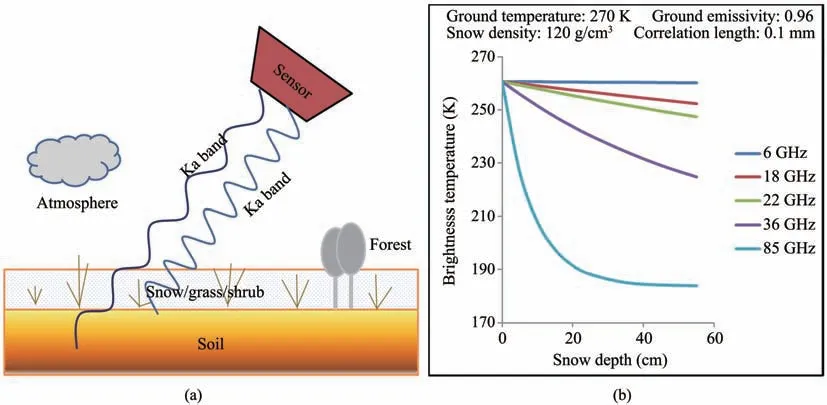
Figure 1 (a)Schematic diagram of microwave emission transfer process of snowpack;(b)Variations in brightness temperatures at 5 frequencies with increasing snow depth at constant snow characteristics
The intensity of volume scattering within a snow‐pack does not only depend on snow depth,but also on other snow characteristics,especially snow grain size which increases with growing snow age and varies spatially.Snow particles with larger grain size have stronger scattering intensity,otherwise the opposite.Chang algorithm assumed a constant snow grain size when simulating brightness temperatures of the snow‐pack(Changet al.,1976,1987),thus introducing large errors in snow depth retrieval(Changet al.,1987;Hall,1987;Fosteret al.,1997;Fosteret al.,2005;Cheet al.,2008,2012).Furthermore,vegeta‐tion cover,especially forest,disturbs the microwave signal emitted out from the snowpack surface.Micro‐wave radiation from the snowpack is absorbed by for‐est which also emits microwave radiation.Thus,the signal arriving at sensors are a mixture of forest and snowpack signals(Ferrazzoli and Guerriero,1996;Pampaloni,2004).Aiming at solving these two prob‐lems,algorithms have been developed(Fosteret al.,1991,1997;Goitaet al.,2003;Fosteret al.,2005;Pullianen,2006;Cheet al.,2008;Daiet al.,2012;Kellyet al.,2013;Jianget al.,2014;Cheet al.,2016).Six typical global and local algorithms,repre‐senting the development of snow depth retrieval from PM in the recent 30 years,are presented below.
2.1 NASA algorithm
The first typical algorithm is NASA algorithm(Equation(2))which modified the coefficientaof Equation(1)and introduced forest fraction to de‐crease the influence of forest(Fosteret al.,1997).
whereais 4.77 for SMMR and 4.8 for SSM/I,fis for‐est fraction.This algorithm was used in the global monthly SWE product which were produced by Na‐tional Snow and Ice Data Center in the United States(NSIDC)based on brightness temperatures from SMMR and the Special Sensor Microwave Imager(SSM/I).However,this algorithm presented underesti‐mation for SWEs over 120 mm,due to signal satura‐tion(Liuet al.,2014).Furthermore,the constant coef‐ficientadid not reflect the temporal variation in snow grain size.
2.2 Foster algorithm
The Foster algorithm was also developed by NASA,which is an updated version of NASA's algo‐rithm.A priori information was introduced in this al‐gorithm,and error coefficients were used to rectify the uncertainties brought in by forest cover and dy‐namic snow grain size(Fosteret al.,2005).The form of the algorithm is the same as Equation(1),but coef‐ficientavaries with snow types and months and the forest error coefficientγvaries with forest cover frac‐tion.The algorithm is expressed as Equation(2).

whereεis the error coefficient for snow types in dif‐ferent months(Table 1).γis error coefficient for for‐est,varying with forest cover fraction(Table 2).Be‐cause this algorithm considered a priori snow informa‐tion,it outperformed the NASA algorithm.However,the error was still large for marine and alpine types.

Table 1 Monthly error coefficientεin different snow types(Foster et al.,2005)

Table 2 Error coefficientγin different forest cover fraction(Foster et al.,2005)
2.3 NASA-AMSRE algorithm
AMSR-E provided PM data with a finer spatial resolution and more frequencies than SSM/I and SMMR.Based on AMSR-E data,NASA developed a new method to retrieve snow depth and SWE(hereaf‐ter called NASA-AMSRE algorithm)(Tedesco and Narvekar,2010).This algorithm was also developed based on the Chang algorithm but has four differences from NASA algorithm.First,the brightness tempera‐ture difference between 10.7 GHz and 18 GHz was used to conquer the saturation problem in spectral dif‐ferenceTb18?Tb36,which occurred in SWE over 100 mm(Kellyet al.,2003)(Equation(3a)).Second,the forest density was considered in the algorithm to de‐crease uncertainties introduced by forest(Equation(3b)).Third,polarization differences were used to re‐flect the varying grain size(Equations(3a)and(3b)).Fourth,spatial and seasonal varying snow density was used to convert snow depth to SWE.Furthermore,snow depths in forested and non-forested areas were derived using different algorithms,and in the mixture pixels partly covered by forest,snow depth is estimat‐ed using Equation(3c).
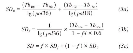
whereSDis estimated snow depth of a mixture pixel,SDfis estimated snow depth in forest area,SD0is esti‐mated snow depth in non-forest area;fis forest cover fraction in a mixture pixel.pol36andpol18are polar‐ization differences at 36 GHz and at 18 GHz,respec‐tively;Tb10v,Tb18vandTb36vare brightness tempera‐tures at 10,18 and 36 GHz for vertical polarization,respectively.
However,the variability of polarization difference is more related to melting/refreezing cycles,changes in soil and vegetation properties than to snow charac‐teristics(Tedesco and Narvekar,2010).Assessment on multiple remote sensing snow depth datasets shows that AMSR-E snow depth presented lowest ac‐curacy over a global scale(Xiaoet al.,2020).
2.4 GlobSnow algorithm
Due to the difficulty in obtaining grain size,a data assimilation scheme was utilized by the European Space Administration(ESA)to estimate snow depth by optimizing the effective grain size(Pullianen,2006).GlobSnow SWE was derived using the data as‐similation scheme which was designed based on a semiempirical snow emission model(Helsinki Univer‐sity of Technology,HUT)andin situsnow depth from global meteorological stations.In the HUT model,an empirical equation(Kruopiset al.,1999;Pullianenet al.,1999)to calculate forest transmissivity at different frequencies was used to simulate the contribution of radiation from forest.
The HUT model was used to simulate brightness temperature at 18 and 36 GHz for vertical polariza‐tion at stations within situsnow depth,SWE and varying grain sizes as inputs.Satellite and simulated brightness temperatures at 18 and 36 GHz were com‐pared to obtain the optimal grain size at each station for each day.Also,grain sizes for an arbitrary location are assumed to be the mean snow grain size estimated at nearby stations.Then,estimated snow grain sizes were applied in the next phase of the assimilation al‐gorithm for snow depth estimation.Figure 2 describes the flowchart of the algorithm.The estimated snow depth was converted to SWE by multiplying them with snow density values that are regional averages obtained from snow climatology(Sturmet al.,1995).

Figure 2 Flowchart of SWEretrieval from PM in GlobSnow algorithm(Pullianen,2006)
Comparisons of different snow depth or SWE products show that GlobSnow SWE presented high‐er accuracy than NASA and NASA-AMSRE prod‐ucts againstin situobservations.However,the accu‐racy of this algorithm is controlled byin situobser‐vation.In mountainous areas with rare snow depth observations,no effective grain size was optimized,thus mountainous areas were masked in GlobSnow.Besides,this algorithm exhibited obvious overesti‐mation in regions with SWE less than 30 mm(Liuet al.,2014),and areas with latitude's less than 35°N were not covered.Thus,GlobSnow is not suitable for snow depth analysis in China where snow cover is mainly distributed in mountainous areas,and most areas of the QTP,which is very sensitive to climate change,was not covered.
2.5 Che algorithm
All global snow depth datasets present overestima‐tion in China.Aiming at improving the snow depth re‐trieval accuracy in China,a local algorithm was devel‐oped by Cheet al.(2008),through establishing the linear relationship between brightness temperature dif‐ference between 18(19)and 36(37)GHz from SMMR and SSMI/I,andin situsnow depth from 178 meteorological stations in China.Hereafter,this algo‐rithm is called the Che algorithm.Due to the systemat‐ic bias between SMMR and SSM/I,algorithms were developed based on these two sensors,respectively(Equation(4)).In this algorithm,monthly average off‐sets were added to remove the influence of grain size variations.
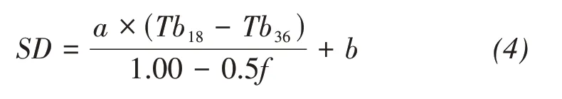
where coefficientais 0.78 for SMMR,0.66 for SSM/I,bis the monthly average offsets,and the value is list‐ed in Table 3.fis the forest cover fraction.
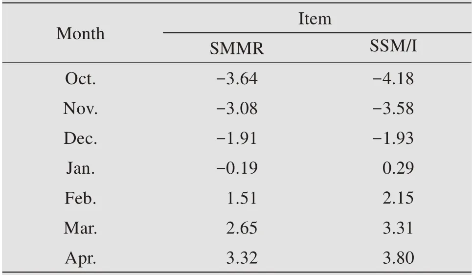
Table 3 Monthly average offsets to remove the influence of variation in grain size with a snow season(Che et al.,2008)
The Che algorithm was used to produce long-term series of daily snow depth in China(http://data.tpdc.ac.cn/en/).This dataset proved to be higher accurate than GlobSnow and AMSR-E snow depth datasets in China,and has been used in studying snow cover change and the response to climate change(Gaoet al.,2012),the effect of snow cover on the growing season of vegetation(Yuet al.,2013;Wanget al.,2017),and the contribution of snow to runoff(Hanet al.,2019a,b).
2.6 FY algorithm
The FY algorithm is a snow depth retrieval algo‐rithm developed by Jianget al.(2014)based on Fengyun-MWRI.In this algorithm,pure pixels of farmland,grassland,barren and forest in China were selected according to the land cover map.For each pure land cover,the stepwise regression analysis was performed betweenin situsnow depth and spectral gradients and polarization differences.Ultimately,the snow depth retrieval algorithm for each land cover was determined as Equations(5a)?(5d).The snow depth in mixture pixels was estimated based on algo‐rithms of pure land cover using the land cover area weighted method(Equation(5e)).The FY algorithm has been used by the China Meteorological Adminis‐tration to produce daily snow depth in China(http://data.nsmc.org.cn/).


Generally,snow depth retrieval algorithms are all developed based on the brightness temperature gradi‐ent method.After 30 years of development,snow depth or SWE retrieval algorithms from PM have been improved,and datasets derived using these algo‐rithms have been extensively used in climatic and hy‐drological research.However,snow depth retrieval is still a challenge in mountainous areas because of the complex topography.Besides,the coarse spatial reso‐lution limits their applications on a watershed scale.
3 Active microwave method
Active microwave remote sensing characterized by high spatial resolution and independence of weath‐er has been utilized to detect snow depth and SWE since the 1980s(Ulaby and Stiles,1980).The estima‐tion of SWE from SAR is based on two principles:back scattering and thermal resistance of snow.
3.1 SAR-back scattering
The backscatter signature over snow cover consists of 4 components:(1)the backscatter from air-snow interface,(2)the backscatter from the snow grains,(3)the backscatter from the snow-ground inter‐face,and(4)the backscatter from the ground,attenu‐ated by snow grains when going through the snow‐pack.In these 4 components,the second and fourth components are the main contributor,and the first and the third are usually ignored(Ulaby and Stiles,1980;Lievenset al.,2019).
In the experiment of Ulaby and Stiles(1980),a 144 cm of snowpack was piled up in five steps,and a 170 cm of snowpack was piled up in six steps.In ev‐ery step,the backscatter coefficient and snow charac‐teristics were measured.The 170-cm snowpack was reduced in depth down to ground level in nine steps,and the backscatter coefficient for every step was measured.Based on experimental data,Ulaby firstly developed an empirical relationship between backscat‐ter coefficient and SWE(Equation(6)).

whereσ0is backscatter coefficient,cis the effective two-way attenuation coefficient,aandbare empirical coefficients.These coefficients vary with frequency,polarization,incidence angle and snow wetness.Based on measurements,a,bandcwere 0.162,0.146,and 0.02 under the condition that incidence angle is 57°,frequency is 9 GHz(X-band),and snow wetness is 0(Figure 3).

Figure 3 Backscatter coefficient response to SWE at 9 GHz(Ulaby and Stiles,1980)
However,the empirical approach is unrealistic,be‐cause the relationship between SWE and backscatter‐ing coefficients can be positive or negative due to the change of subsurface and snow conditions.Shi and Dozier(2000)estimated snow depth from SIR-C/X SAR based on a physically-based backscattering model at constant incidence angle and polarization.The X-band backscatter sensitivity to dry snow at different polarizations and incidence angles was first‐ly analyzed by a theoretical model,Dense Media Ra‐diation Transfer model(DMRT)(Tsanget al.,2007).This model was further verified by Pettinatoet al.(2013)which conducted snow characteristics obser‐vation in eastern Italian Alps,and obtained the re‐gression equations between both simulated backscat‐ter coefficients by DMRT and backscatter coeffi‐cients measured by COSMO-SkyMed images andin situSWE(Equation(7)).

whereais 8.8 and 8.68 for simulation and measure‐ment,respectively.bis?61.64 and?62.7 for simula‐tion and measurement,respectively.The simulation and observation had a good agreement.
However,simulations and observations showed that an appreciable sensitivity of X-band backscatter to dry snow was found for SWE higher than 100 mm.Equation(7)was also determined by data with SWE higher than 100 mm,and proved high accuracy for SWE larger than 200 mm.This problem was also re‐ported by Bernier and Fortin(1998)which revealed that volume scattering of snowpack with SWE less than 200 mm was undetectable by SAR and the back‐scattering power was dominated by soil surface,based on three-winter experiments.The SAR-volume scatter method was also used for C-band to derive snow depth(Pivot,2012;Lievenset al.,2019).Lievenset al.(2019)found that the backscattering ratio of VH cross-polarization and VV co-polariza‐tion have better correlation with snow depth than backscattering from single polarization.Weekly vari‐ability in snow depth in the Northern Hemisphere Mountains was mapped using the ratio method based on Sentinel-1 SAR images with high-temporal reso‐lution of approximately 6 days.However,the varia‐tion in snow characteristics,such as grain size and snow density,produce sharp change of backscatter coefficient(Pettinatoet al.,2013),and the ground characteristics and vegetation interrupt backscatter signals(Lievenset al.,2019),introducing uncertain‐ties for SWEestimation.
3.2 SAR-thermal resistance
Due to snow thermal resistance,the underlying soil temperature varies with SWE and influence the liquid water content.The soil dielectric constant is changed by the soil temperature under the condition of soil temperature lower than 0°C.For shallow snow cover,SWE can be theoretically derived from back‐scatter coefficient based on the snow thermal resis‐tance(Bernier and Fortin,1998;Bernieret al.,1999).This method is described as follows:
The snow thermal conductivity(k)is firstly calcu‐lated from snow density by an empirical method(Raud‐kiviet al.,1979)(Equation(8a)).Then,the snow thermal resistance(R,(°C·sm2/J))is computed based onk(J/(°C·m))and snow depth by Equation(8b);Fi‐nally,the relationship betweenRand backscatter coeffi‐cient difference between snow-free and snow-covered periods is obtained(Equation(8c)).
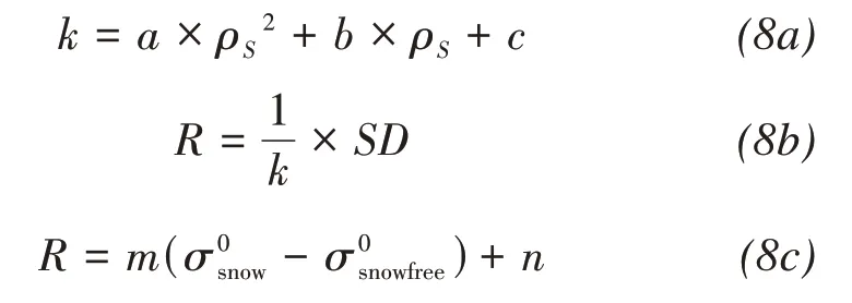
wherea=2.83056×10?6;b=?9.09947×10?5;c=0.0 319739;ρSis snow density in kg/m3;SD is snow depth;is backscatter coefficient of snow covered ground;is backscatter coefficient;mandnare regres‐sion coefficients.
Sunet al.(2015)adopted this method to estimate SWE of dry snow cover in Binggou watershed from ASAR data,and found that the empirical method re‐lied onin situobservation.When snow depth exceeds a threshold the underlying soil temperature will not change.Furthermore,the liquid water content in soil is not only influenced by temperature but also other factors such as melted snow.The backscattering does not only depend on the soil dielectric constant but al‐so other factors such as snow volume scattering,to‐pography and land cover.Therefore,this method was seldom utilized to derive snow depth.
4 Altimetry technique
Satellite altimetry techniques are extensively used in snow depth measurements in recent decades,such as InSAR and Lidar.
4.1 InSAR
Guneriussenet al.(2001)was the first to use inter‐ference technique in snow depth retrieval.Due to the difference in dielectric properties between air and snow,the radar beam is refracted when going through the air-snow interface (Figure 4).In a homogenous dry snowpack,the volume scattering of snow parti‐cles at C or X bands is small;thus,the volume scatter‐ing effect on the interferometric phase was assumed to be negligible,and the refractive angle (θr) is deter‐mined by snow density (Equation(9a)).The phase difference is generated between the microwave path for snow free (ΔR0) and refraction path in dry snow‐pack (ΔRs+ΔRa).Given snow density,snow depth is the dominant factor controlling the phase difference,and can be deduced by the phase difference (Equation(9b)).Studies of Engenet al.(2004),Deebet al.(2011) and Esmaeilyet al.(2010) further proved the possibility of using this method in deriving SWE.With the launch of high-temporal satellite sentinel-1,more SAR images can be obtained,providing poten‐tial to estimate time series of snow depth (Condeet al.,2019).

Figure 4 Geometry of microwave refraction in dry snowpack.The solid line(ΔRs+ΔRa)is the microwave path in dry snowpack,and the dashed line ΔR0 is the microwave path in the snow-free condition.SD is snow depth
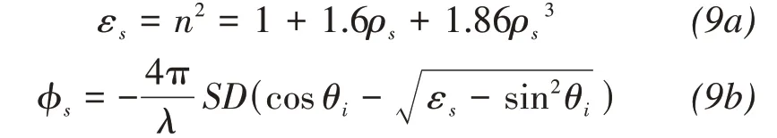
whereεsis relative dielectric constant of snow,nis re‐fractivity,ρsis snow density,φsis phase difference,λis wavelength,SDis snow depth,andθiis incidence angle.
This method was developed based on the assump‐tion that snow characteristics within a snowpack are homogeneous and the scattering of snow grains can be ignored.Actually,natural snowpack tends to pres‐ent multiple layers with different snow density and grain size.The snow density change will change the beam direction,and the assumption of homogeneity may cause large errors.Furthermore,the volume scat‐tering within snowpack which is neglected in this method will introduce large noise or error,especially for deep snowpack.The uncertainties for SAR meth‐od brought in by ground characteristics and vegeta‐tion also exist in InSAR method.
4.2 Lidar
Lidar is an efficient method to measure topography surface height through the time gap between emitting and receiving photons,and was later extended to esti‐mate snow depth.In recent decades,Lidar is a very popular method to derive snow depth on a watershed scale.Snow depth can be obtained by calculating the height difference between snow covered ground and snow free ground.Many airborne Lidar experiments were performed to detect snow depth on a watershed scale (Kirchneret al.,2014;Painteret al.,2016;Curri‐eret al.,2019;Skaugen and Melvold,2019).
ICESat-GLAS was the first satellite Lidar instru‐ment for continuous global observations of Earth,and was designed to measure ice-sheet topography.It was proved to have the potential to provide snow depth on a regional scale with decimeter-scale accuracy,given an accurate reference DEM (Treichler and Kaab,2017).However,its low temporal resolution and sus‐ceptible to cloud interference,leading to sparse spa‐tial sampling,restricted its application in monitoring daily,weekly,even monthly variations in snow depth.Besides,Lidar data are of point cloud data.When con‐verting Lidar point snow depth to areal snow depth in a watershed,the upscaling method must be per‐formed,and the method in a watershed is hard to be applied in another watershed.
5 Discussions and Summaries
In summary,passive microwave remote sensing is the most efficient method to monitor long-term snow depth or SWE in global and regional scales,due to its temporal resolution of one day and long time series of satellite data;while SAR and Lidar have large poten‐tial to estimate snow depth on a watershed scale,due to their high spatial resolution.
Although the snow depth derivation algorithm has experienced significant progress and numerous daily snow depth or SWE products have been produced based on passive microwave remote sensing and used in climate and hydrology research,uncertainties re‐main to be discussed.The first uncertainty comes from the Snowpack Microwave Radiative Transfer Model (SMRTM).Snow depth retrieval algorithms are generated from SMRTM,in which the calculation of volume scatter coefficients at different frequencies is crucial to the simulation accuracy.The microwave emission model of layered snowpacks (MEMLS)(Matzler and Wiesmann,1999),the HUT (Pulliainenet al.,1999),and the DMRT (Tsanget al.,2000) are the main SMRTM for snow depth derivation algo‐rithm.However,these models adopt different calcula‐tion method of volume scatter coefficients,and this difference results in large difference of simulated brightness temperatures (Tedesco and Kim,2006).Even the MEMLS,which showed highest consistency with in situ observation among these models,present‐ed different simulation accuracy in different frequen‐cy (Tedesco and Kim,2006;Lemmetyinenet al.,2016).Therefore,an integrated microwave radiome‐try experiment was carried out to further understand the influence of snow characteristics on the micro‐wave brightness temperature,and new volume scatter model was developed to enhance the simulation accu‐racy(Daiet al.,2022).
The second uncertainty is generated from inaccu‐rate inputs of snow characteristics.Snow characteris‐tics,especially grain size,vary spatiotemporally.Some studies performed a large number of snow pit observa‐tion to summarize a priori snow characteristics to im‐prove the simulation accuracy in some regions (Daiet al.,2012;Cheet al.,2016).However,the snow char‐acteristics cannot be observed in mountainous areas or areas hard to reach.Therefore,the snow process models,such as SNOWPACK,SNTHERM,are anoth‐er choice to obtain snow characteristics (Chenet al.,2020;Yuet al.,2021).Actually,Cheet al.developed assimilation method to combine land surface model with SMRTM to improve the estimation snow depth(Cheet al.,2014).The land surface model could pro‐vide continuous snow characteristics.Currently,this method has been only tested in point scale.
The third uncertainty is that the coarse spatial res‐olution impeded their application on a watershed scale.Therefore,studies on combining optical and passive microwave remote sensing were conducted to retrieve snow depth with higher spatial resolution(Gaoet al.,2010;Huanget al.,2016;Daiet al.,2018).These combination methods improved the esti‐mation accuracy in mixture pixels,but did not solve the saturation of microwave signal caused by deep snow and multiple scattering between slopes in moun‐tainous areas with complicated topography.
The present satellite SAR images are of C or X-band which has strong penetrability,and has poten‐tial to detect deep snow,but is more sensitive to sub‐surface than to snow characteristics;thus,large uncer‐tainties exist in snow depth retrieval.The Lidar altim‐etry can be efficiently used to measure snow depth,but rare available satellite Lidar data does not allow it to be widely applied.However,rare snow depth mea‐surements,especially in mountainous areas where it is very difficult forin situdata collection,are important sources for validation data.
With the increasing number of freely available re‐mote sensing data and in situ data sharing,machine learning methods and data assimilation play important roles in the retrieval of earth parameters including snow depth (Cheet al.,2014;Xiaoet al.,2018;Huet al.,2021).However,the accuracy also depends on in situ observation.Estimation of snow depth in moun‐tainous areas with rare in situ observations is still a challenge.
In space remote sensing,passive microwave and SAR are two main data sources in monitoring snow depth.Scattering is the key issue in both remote sens‐ing methods and the link between them.SAR has the advantage in deep snow detection and high spatial res‐olution which are the shortcoming of passive micro‐wave.Therefore,it would be beneficial to combine ac‐tive and passive microwave to retrieve snow depth in the future.
Acknowledgments:
This research was supported by the National Key Re‐search and Development Program of China (Grand No.2020YFA0608501),the National Natural Science Foundation of China (Grand No.42171143),and the CAS'Light of West China'Program(E029070101).
 Sciences in Cold and Arid Regions2022年2期
- Sciences in Cold and Arid Regions的其它文章
- Guidelines to Authors
- Simulation assessment and prediction of future temperatures in Northwest China from BCC-CSM Model
- Effect of GGBS on performance deterioration of non-dispersible underwater concrete in saline soil
- Diversity and composition of culturable fungi in Horqin Sandy Land
- Coarse fragment content influences estimates of soil C and N stocks of alpine grassland on the northeastern edge of Qinghai-Tibetan Plateau,China
- Influence of meteorological elements on chemical evolution of snow and ice of Urumqi Glacier No.1,eastern Tianshan Mountains