
Zhangmu and Gyirong ports under the threat of glacial lake outburst flood
2020-03-29 08:06:50MiaoMiaoQiShiYinLiuYongPengGao
MiaoMiao Qi,ShiYin Liu,3*,YongPeng Gao
1.Yunnan Key Laboratory of International Rivers and Transboundary Eco-Security,Yunnan University,Kunming,Yunnan 650091,China
2.Institute of International Rivers and Eco-security,Yunnan University,Kunming,Yunnan 650091,China
3. State Key Laboratory of Cryospheric Sciences, Northwest Institute of Eco-Environment and Resources, Chinese Academy of Sciences,Lanzhou,Gansu 730000,China
ABSTRACT The Himalayas are prone to glacial lake outburst floods, which can pose a severe threat to downstream villages and infrastructure. The Zhangmu and Gyirong land treaty ports are located on the China-Nepal border in the central Himalayas. In recent years, the expansion of glacial lakes has increased the threat of these two port regions. This article describes the results of mapping the glacial lakes larger than 0.01 km2 in the Zhangmu and Gyirong port regions and analyzes their change. It provides a comprehensive assessment of potentially dangerous glacial lakes and predicts the development of future glacial lakes. From 1988 to 2019, the glacial lakes in these port regions underwent "expansion",and moraine-dammed lakes show the most significant expansion trend.A total of eleven potentially dangerous glacial lakes are identified based on the assessment criteria and historical outburst events; most expanded by more than 150% from 1988 to 2019, with some by over 500%. The Cirenmaco, a moraine-dammed lake, is extremely prone to overtopping due to ice avalanches or the melting of dead ice in the dam. For other large lakes, such as the Jialongco, Gangxico and Galongco, ice avalanches may likely cause the lakes to burst besides self-destructive failure. The potential dangers of the Youmojianco glacial lakes, including lakes Nos. 9, 10 and 11, will increase in the future. In addition, the glacier-bed topography model predicts that 113 glacial lakes with a size larger than 0.01 km2, a total area of 11.88 km2 and a total volume of 6.37×10⁹ m3 will form in the study area by the end of the 21 century. Due to global warming, the glacial lakes in the Zhangmu and Gyirong port regions will continue to grow in the short term,and hence the risk of glacial lake outburst floods will increase.
Keywords:Zhangmu and Gyirong ports;glacier lake expansion;potentially dangerous glacial lakes;future lake development
1 Introduction
In recent years,the glaciers in the Himalayas are re‐treating with the most negative mass balance and the greatest shortening in length (Gardelleet al., 2011;K??bet al., 2012; Yaoet al., 2012; Cogley, 2016;Sakai and Fujita, 2017; Maureret al., 2019). The gla‐cier shrinkage is accompanied by various glacial haz‐ards and the formation of numerous glacial lakes at the glacier terminus (Nieet al., 2013, 2017, 2018; Zhanget al., 2015; Kinget al., 2017, 2018; Liuet al., 2020),which pose a severe threat to downstream village resi‐dents and can result in catastrophic socio-economic di‐sasters (Dubey and Goyal, 2020). Glacial lake outburst flood (GLOF), a typical glacial hazard, is the sudden discharge of a large amount of stored water from gla‐cial lakes (Carrivick and Rushmer, 2006). Its trigger‐ing factors mainly include self-destructive and exter‐nal factors. Among them, the self-destructive factor refers to the settlement of ice-cored moraine or unsta‐ble moraine structure (Dubey and Goyal, 2020).Floods from sudden moraine-dam failures are charac‐terized by the often short-lived passage of high-mag‐nitude floodwaters with a very complex process(Marren, 2005; Carrivick, 2010). The moraine dam's outburst mechanism mainly depends on the trigger factors, water depth, its geometry, composition and structure, as well as the topography of the down‐stream river channel (Westoby, 2014). In Europe,GLOFs and mudslides are the most frequent types of glacier disaster and cause the most deaths (Haeberli,1983; Huggelet al., 2002, 2003). In the Cordillera Blanca region of Peru, GLOFs caused very shocking numbers of casualties. Distressing cases, such as the 1941 Coupup glacial lake burst, resulted in more than 6,000 deaths (Clague and Evans, 1994); the 1991 Huascaran glacial lake burst formed a mud‐slide, which destroyed the Yungay Town down‐stream and killed nearly 2,000 people (Carey, 2005).Therefore, local governments and academia are de‐voting more attention and resources to study GLOF events and potentially dangerous glacial lakes (Wuet al.,2019).
At present, there is an increasing trend of GLOFs in the Himalayas. At least 23 debris flows due to gla‐cial lake outbursts occurred as of 2016 (Caoet al.,2016).According to the inventory of glacier floods and the maximum number of causalities due to glacial haz‐ards for the central Himalayas (Carrivick and Tweed,2016), while fewer floods have been observed in Ne‐pal and India,the damage was more severe.For exam‐ple, Dig Tsho glacial lake in Nepal burst and de‐stroyed the newly completed Namchi Hydropower Station in 1985, causing huge economic losses (Bolchet al., 2008).The Zhangmu port region (ZPR) and the Gyirong port region (GPR), located on the China-Ne‐pal border in the central Himalayas, are important in‐ternational trading ports. The ZPR and GPR, adjacent to each other,belong to the Poiqu River Basin and Gy‐irong River Basin, respectively. Such factors as steep terrain, strong tectonic movements, frequent seismic activities, and abundant rainfall could lead to GLOFs,hence impacting the accessibility of the two ports.Ac‐cording to existing records, there have been eight out‐burst floods at six glacial lakes in the ZPR and GPR since 1935, as summarized in Table 1. These GLOFs triggered various degrees of debris flows, causing fa‐talities and property damages in the downstream vil‐lages. For example, the Cirenmaco glacial lake burst in 1981, which destroyed the China-Nepal Friendship Bridge and buildings on both sides, damaged the Sunksi Hydropower Station in Nepal and killed 200 people (Kattelmann, 2003). Another example is the outburst flood of the Gongbatongsha Tsho glacial lake in southeast Tibet, which formed a sparse mudslide and damaged the Bhotekoshi hydropower station in Nepal, inflicting an economic loss of up to 70 million US dollars (Nieet al., 2018). In the context of global environmental changes, these disastrous events may become more severe and frequent.The poor mountain residents are extremely vulnerable in the face of these natural disasters and cannot cope with these abrupt di‐sasters.Therefore,to prevent and mitigate these disas‐ters in advance, it is necessary to assess the potential‐ly dangerous glacial lakes (PDGLs) in the ZPR and GPR and collect essential data to simulate future GLOF disasters.
To this end, this study aims to (1) map the distri‐bution of glacial lakes using remote sensing images;(2) analyze the dynamic changes of glacial lakes from 1980 to 2020; (3) assess PDGLs, and (4) predict the potential locations of glacial lake development in the future under climate warming and continued glacier retreat in the ZPR and GPR.
2 Study area
The Zhangmu port, one of China's first-class land treaty ports,is located at the bottom of the Zhangzang‐bo gully in Zhangmu town,Nyalam county,the south‐ern foothills of the Himalayas. It was seriously dam‐aged during the April 2015 Nepal earthquake and still remains closed at present. The Gyirong port, one of the main exit channels in Tibet's history, is located in the famed scenic Gyirong gully at the lower reaches of the Gyirongzangbo river in the southern foothills of the Himalayas. It is the only open trading port be‐tween China and Nepal (Jianget al., 2018) after the shutdown of the Zhangmu port in 2015. Presently, the trade through the Gyirong port accounts for a large proportion of the total between Tibet and Nepal.
The Zhangmu port is located at the Poipu River Ba‐sin(85°40′E?86°20′E,27°20′N?28°40′N),south of Ny‐alam county (Figure 1). Glaciers and firn areas are dis‐tributed above 4,440 m a.s.l.,accounting for 45.15%of the total basin area (Chenet al., 2003). Since the Qua‐ternary period, the neotectonic movement in the water‐shed is very strong, and the crustal uplift has reached more than 4,000 meters. Under the intense erosion and cutting effect of the water flow, the valley's maximum height difference exceeds 2,000 m(Liet al.,2014).The Zhangzangbo gully closest to the Zhangmu port has a depth of about 40?100 m, and its ridges on both sides have steep slopes exceeding 40° (Wanget al., 2015).The geological structure in the gully is complex, with rock mass joints and fissures developed under gravity and prominent geological actions.Therefore,the moun‐tains on both sides of the valley are prone to landslides and collapses (Chenet al., 2003).The Poipu River Ba‐sin experiences a mountainous subtropical humid cli‐mate,which is warm and humid with abundant precipi‐tation(Tianet al.,2005).
The Gyirong port is located in the Gyirong River Basin(85°01′E?85°09′E,27°44′N?28°58′N)(Figure 1),in which lies the Gyirong gully, one of the five grand canyons in the Everest National Nature Reserve. The Gyirong River Basin is a band-shaped alpine gorge extending from the higher north end to the lower south end with a narrow width in the east-west (Li,2012). Abundant water vapor conditions and changing topographic/landform types created diverse soil types in the study area.The Gyirong gully is one of the vital water vapor channels in the Himalayas that transports the Indian Ocean's warm and humid air under the Indi‐an high pressure to the interior of the plateau in sum‐mer, forming a subtropical mountainous monsoon climate zone with rich water and heat conditions(Li,2012).
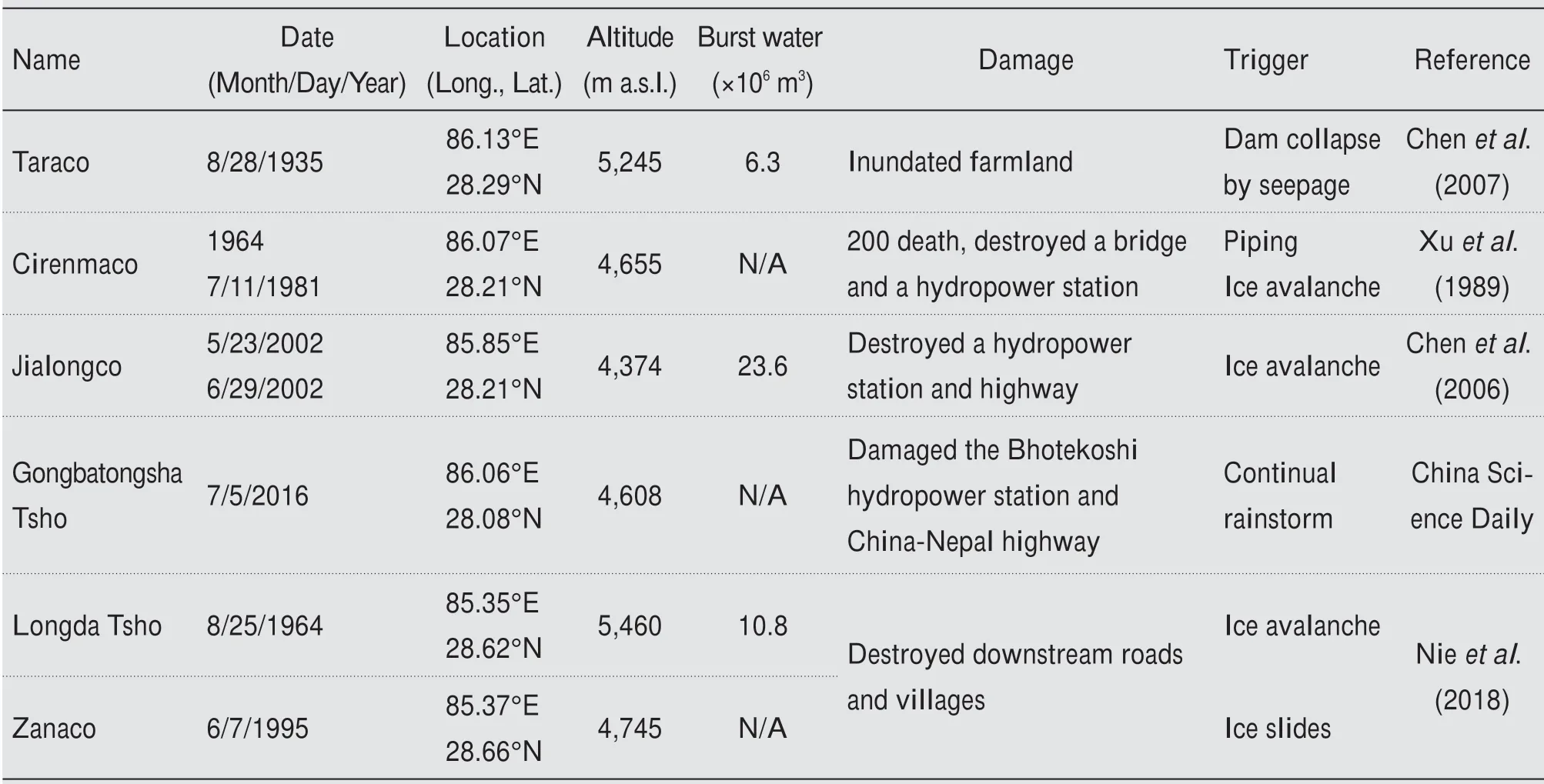
Table 1 Historical GLOF events in the ZPR and GPR
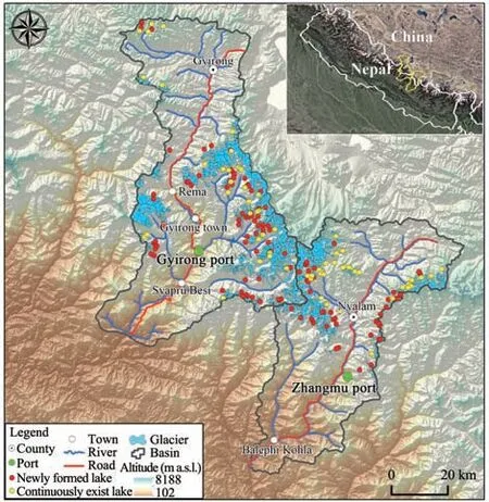
Figure 1 Map of the Zhangmu and Gyirong Port Region
3 Data and method
3.1 Data sources
The ZPR and GPR are located across two Land‐sat scenes (Path/Row: 141/040 and 141/041).As list‐ed in Table 2, a total of 28 Landsat images (20 TM and 8 OLI) from 1988 to 2019 were requested to map glacial lakes. Previous research (Nieet al.,2017) has shown that little seasonal changes take place in glaciers and glacial lakes from September to December. Therefore, all images between September and December were screened to map glacial lakes. It is difficult to acquire ideal-quality imageries during the same month due to frequent cloud cover in the central Himalayas. As a result, some were replaced by the images from one year before or after to ensure data integrity. All these data were provided by the United States Geological Survey (USGS) (http://glo‐vis.usgs.gov).
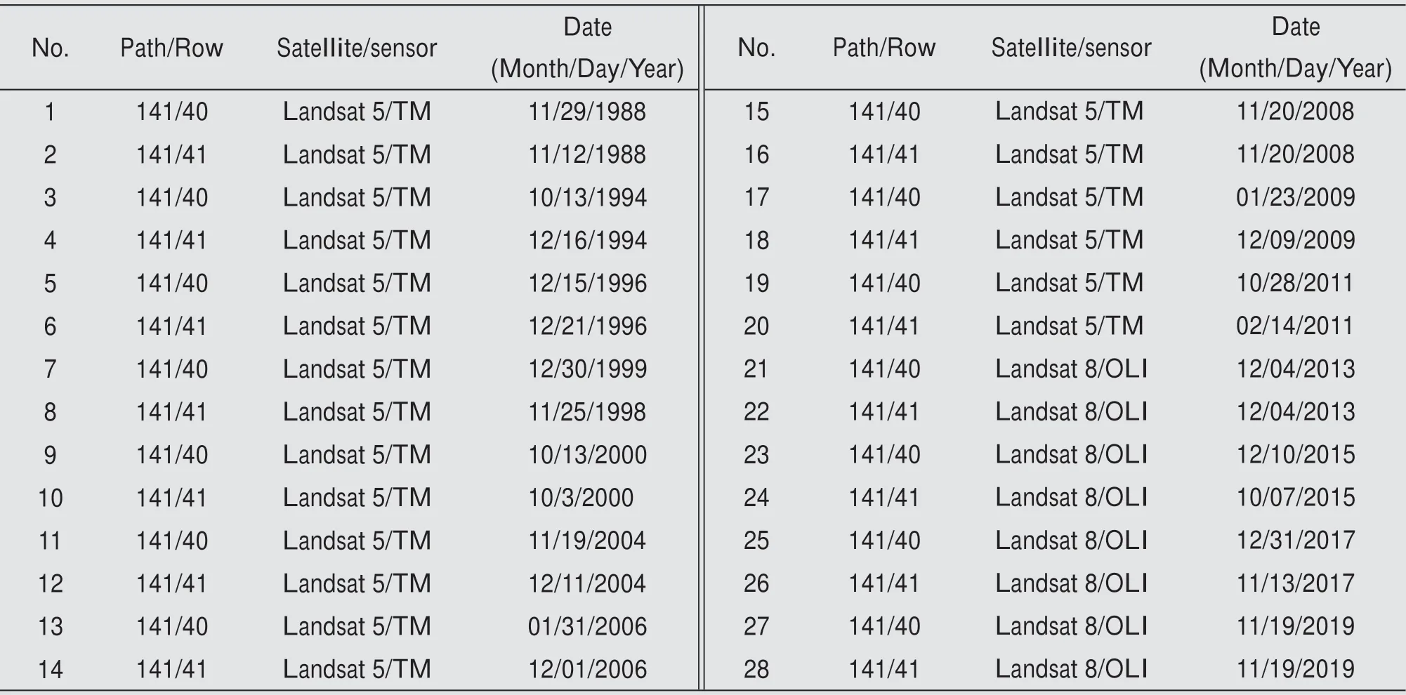
Table 2 Landsat images used to map glacial lakes
Farinottiet al. (2019) used an ensemble of up to five models to offer a consensus estimate for the ice thickness distribution of about 215,000 glaciers out‐side the Greenland and Antarctic ice sheets. The re‐sulting ice thickness distributions can provide the bed topography,i.e., a Digital Elevation Model (DEM),without glaciers (Linsbaueret al., 2016). Therefore, a dataset of ice thickness distribution(http://www.glims.org/RGI/) was used to detect the potential location of glacial lakes in the future. Other datasets used in this study include high-resolution images from Google Earth, the Shuttle Radar Topography Mission (SRTM 1-arc, 30 m) from USGS, and the Randolph Glacier Inventory(RGI 6.0)(http://www.glims.org/RGI/).
3.2 Method
3.2.1 Extraction of glacial lake boundary
No consensus on the definition of glacial lakes ex‐ists among researchers (Lüet al., 1999; Wanget al.,2013;Yaoet al.,2018).This study adopted the defini‐tion of glacial lakes proposed by Yaoet al. (2018) to conduct the GLOF hazards assessment. Besides, fol‐lowing Wanget al.(2013), a distance limitation was added. Namely, only the lakes within 10 km from the glacier terminus are considered as glacial lakes. Based on how they are associated with glaciers, the lakes were classified as moraine-dammed or glacier-fed con‐nected,glacier-fed unconnected,and supraglacial.
The lake information can be obtained by an objectoriented automated algorithm, such as the water body index method, single-band threshold method, ratio method and spectral classification method (Gardelleet al., 2011). In this study, all glacial lakes were mapped via the normalized difference water index (NDWI)(Mcfeeters, 1996), with each double-checked by visu‐al inspection. All lakes with an area of ≥0.01 km2in the ZPR and GPR were included for further investiga‐tion. Meanwhile, the glacial lake's location and name were determined based on Google Earth andRecords of lakes in China(Wang,1998).
Factors such as data quality, image resolution,geometric registration and the automatic boundary ex‐traction algorithm may affect the accuracy of the lake boundary. To quantify the uncertainties caused by these factors, the formula proposed by Wanget al.(2012) was used to calculate the error in lake area evaluation due to boundary extraction. The results show that the error of the lake area is ±1.10 km2for 1988, ±1.50 km2for 1998, ±1.61 km2for 2008, and±2.43 km2for 2020.
3.2.2 Identification of potentially dangerous glacial lakes
Many factors can lead to the outburst of a glacial lake. In particular, the external factors, including ice/snow avalanche, rockfall and suddenly increased rain‐fall (Westobyet al., 2014; Dubey and Goyal, 2020),which are abrupt and associate with great uncertainty,increase the difficulty of index selection and the com‐plexity of glacial lake outburst evaluation.For the iden‐tification of PDGLs,this article used the five indicators as listed in Table 3, including certain attributes of the glacial lake,moraine dam and mother glacier.In gener‐al,ice-dammed lakes and moraine-dammed lakes con‐sist of heterogeneous materials of different sources,and hence, are more prone to burst. Therefore, this study mainly focuses on these two types of lakes.
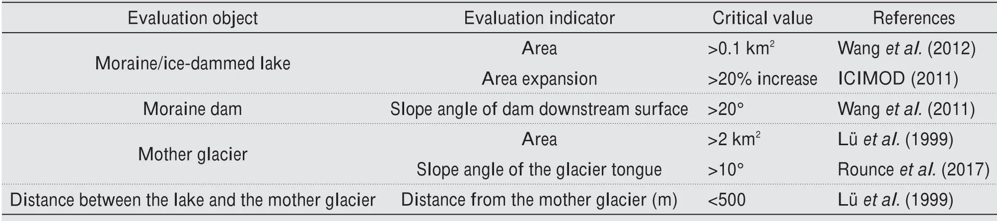
Table 3 The criteria for the identification of PDGLs
The area is one of the most important indicators for a glacial lake's risk; a glacial lake is potentially dangerous only when its size reaches a specific scale.According to the results of empirical formulae and flood evolution model simulation, a glacial lake out‐burst may cause damage to the downstream villiages when its area is greater than 0.1 km2. The expansion rate of a glacial lake is also an important indicator to consider (Wanget al., 2011; Rounceet al., 2017). In this study, the area expansion of more than 20% is used as one of the indicators for selecting PDGLs.The mechanism of self-destructive failures is relative‐ly complicated, and field data is required to evaluate the risk of self-destruction of a moraine dam. Under certain conditions, the mean slope of a moraine dam from the DEM can dictate its stability (ICIMOD,2011; Wanget al., 2011). For example, Dubey and Goyal(2020)evaluated the stability of a moraine dam by its mean slope.
GLOF is also closely related to the activity of the mother glacier.The mother glacier area can reflect the accumulation zone and material sources and suggest the magnitude of snow and ice avalanches if they oc‐cur.As one of the trigger factors of the GLOF,ice col‐lapse is closely related to the slope of the glacier tongue. At present, the potential ice avalanche area can be predicted by setting a threshold for the glacier tongue slope (Westobyet al., 2014). The possibility of an ice avalanche entering a glacial lake and its tra‐jectories can be estimated by the distance between the lake and mother glacier in combination with the DEM(Dubey and Goyal,2020).
3.2.3 Model prediction of glacial lakes in the future
Theoretically, glacier bed topographies can be simulated via the DEM and estimated glacier thick‐ness. Linsbaueret al. (2016) successfully obtained glacier bed topographies with this method and deter‐mined that such bed topographies can contain numer‐ous overdeepenings due to the erosive power of gla‐ciers, which, when exposed after glacier retreat, may fill with water and form new lakes.As early as 1994,some scholars thought that the proglacial lake would develop and expand, when over deepened subglacial basins became proglacial depressions due to glacier retreat (Clague and Evans, 2000).Allenet al.(2016)identified sites capable of potential future lake for‐mation and possible expansion of existing lakes based on detecting overdeepenings in the glacier bed topographies. With the same method, this study first obtained glacier bed topographies by using ice thick‐ness distribution and the DEM data and filled them using the hydrology tool of ArcGis 10.7 software.Then, the slope angles of the filled DEM were calcu‐lated, and those slopes with angles less than 1° were selected within the glacier outlines as the overdeep‐enings in the glacier beds. Eventually, the area and volume of the overdeepenings can be quantified by the difference between the filled DEM and the gla‐cier bed topographies. The overdeepenings can then be understood as potential glacial lakes, and their mean and maximum depths were calculated using zonal statistics.
4 Results
4.1 Glacial lake inventory
In 2019, 180 glacial lakes corresponding to a total area of 26.23±2.43 km2above 3,900 m a.s.l. were identified in the ZPR and GPR, including five suprag‐lacial lakes, 65 moraine-dammed lakes, and 110 gla‐cier-fed unconnected lakes,as listed in Table 4.Among them, glacier-fed unconnected lakes are the most com‐mon type, accounting for 61% of all lakes, whereas moraine-dammed lakes covered the largest area,i.e.,17.64±1.21 km2,or 67%of the total.
Glacial lakes mainly distribute between 4,300 m a.s.l.and 5,600 m a.s.l.,and their number and area first rise and then fall with the increase of altitude, as illustrat‐ed in Figure 2a. The statistics show that the number and area of the glacial lakes between 5,000 m a.s.l.and 5,300 m a.s.l.account for 49%and 70%of their re‐spective total in 2019. Besides, glacier-fed unconnect‐ed lakes were found to have the highest average alti‐tude, followed by moraine-dammed lakes, and finally,supraglacial lakes (Table 4). The number of glacial lakes gradually decreased with rising area size class in the basin,and most of the glacial lakes,i.e.,78%of the total, were less than 0.1 km2in area (Figure 2b).In contrast, lakes larger than 1.0 km2occupied an area of 11.94 km2or 46% of the total. Among the lakes within the area size class of greater than 1.0 km2, the moraine-dammed lakes occupied the largest area,i.e.,83%of the total.
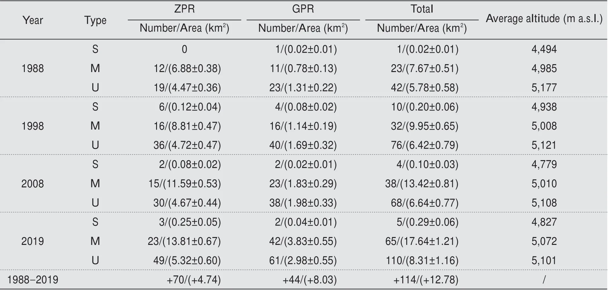
Table 4 Numbers and areas of glacial lakes in the ZPR and GPR between 1988 and 2018
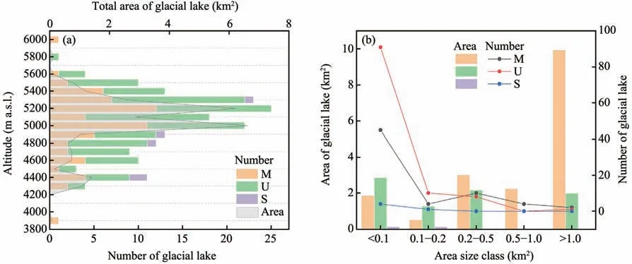
Figure 2 Distribution of glacial lakes in different altitude zones and size classes of the ZPR and GPR in 2019(Note:S,M,and U represent supraglacial lakes,moraine-dammed lakes,and glacier-fed unconnected lakes,respectively,and this applies to other figures hereafter)
4.2 Glacial lake change
From 1988 to 2019, the glacial lakes in the ZPR and GPR underwent a process of "expansion", with their number increased by 169% and their area en‐larged by 95% (Table 4). Moraine-dammed lakes show an average area expansion rate of 3.36 km2/a,the larg‐est among all types of lakes, and their number rose from 23 to 65 from 1988 to 2019(Figure 3).Although the area expansion of glacier-fed unconnected lakes is not obvious, the number increased significantly, from 42 in 1988 to 110 in 2019. Compared with the other two types of lakes,both the number and area of supra‐glacial lakes are relatively small, showing unstable and dynamic changes. It is worth mentioning that the number of supraglacial lakes was the largest in 1988 and gradually decreased since. It is speculated that this may be because the glacier retreat during this pe‐riod has the largest negative mass balance.
In the past 30 years, a total of 64 glacial lakes in the ZPR and GPR,albeit with expansion or shrinkage,continuously existed (Figure 4a). Most of the continu‐ously present lakes have a small area. Only two mo‐raine-dammed lakes and one glacier-fed unconnected lake with a size greater than 2 km2experienced a sig‐nificant expansion. Statistics analyses reveal that 116 new glacial lakes formed, and only two disappeared between 1988 and 2019(Figure 4b).Most of the new‐ly-formed glacial lakes are located at the end, or ei‐ther side of the glacier terminus, between 4,500 and 5,500 m a.s.l. and are supplied by ice and snow melt‐water. This phenomenon confirms that glacier retreat in high altitude zones affects glacial lake develop‐ment.These lakes developed mainly due to the retreat of glacier terminus, which constantly eroded the ter‐rain or moraine blocking the underwater passages,formed overdeepenings at the end, and accumulated water.Also,a few glacial lakes are located on the larg‐er glacier surface covered with debris.They were cre‐ated by water accumulated in the depression formed by differential melting of the glacier surface.
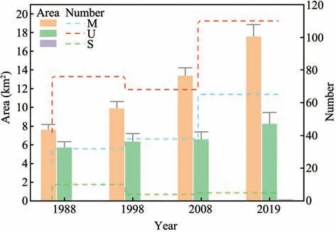
Figure 3 Variation of the number and area of glacial lakes in the ZPR and GPR from 1988 to 2019
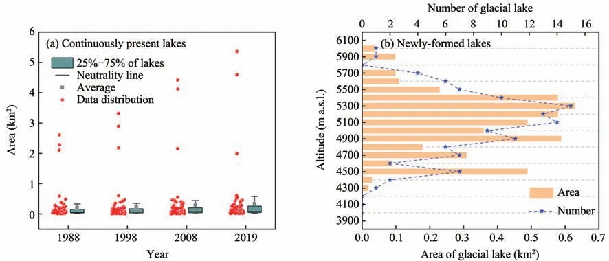
Figure 4 Change of continuously present lakes from 1988 to 2019(a)and altitudinal distribution of newly formed lakes in 2019(b)
Although glacial lakes in the GPR and ZPR gener‐ally underwent an "expansion" in the past 30 years,there are significant differences in the area change trend among glacial lakes of different size classes.Spe‐cifically, the area change in moraine-dammed lakes is more significant than glacier-fed unconnected lakes(Figure 5a). Smaller moraine-dammed lakes (<0.1 km2)experienced a dramatic surge in number, from 12 in 1988 to 45 in 2019, trailed by the lakes of size class 0.2 ?0.5 km2with a modest increase in number. Al‐though moraine-dammed lakes larger than 1 km2re‐mained the same in number,they grew very rapidly in size from 1988 to 2019, requiring attention in the fu‐ture assessment of potential outbursts. The number and area of glacier-fed unconnected lakes with an ar‐ea <0.1 km2also had the fastest expansion rate from 1988 to 2019 (Figure 5b). In general, their area re‐mained relatively stable, although the number of this type of glacial lakes with size classes of 0.1?0.2 km2and 0.2?0.5 km2slightly increased in the same period.
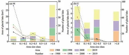
Figure 5 Variation of the number and area of moraine-dammed lakes(a)and glacier-fed unconnected lake(b)of different size classes from 1988 to 2019
The glacial lakes in the ZPR and GPR mainly dis‐tribute between 4,300 and 5,600 m a.s.l., and various types of glacial lakes have different distribution charac‐teristics that vary over the year,as depicted in Figure 6.Note that the sphere color represents the total area of a glacier lake type at each altitude, while the sphere size indicates the total number. In general, the number and area of moraine-dammed lakes expanded significantly between 4,900 and 5,300 m a.s.l..In contrast,the num‐ber of glacier-fed unconnected lakes changed slightly,and their area was stable in different altitude zones.Besides, moraine-dammed lakes gradually expanded,and new ones were formed at higher altitudes after 1988. In terms of both number and size, all types of glacial lakes at lower altitudes remained relatively sta‐ble, whereas those at higher elevations expanded rap‐idly, likely due to their concentrated distribution and intense glacier retreat in the higher altitude zone.
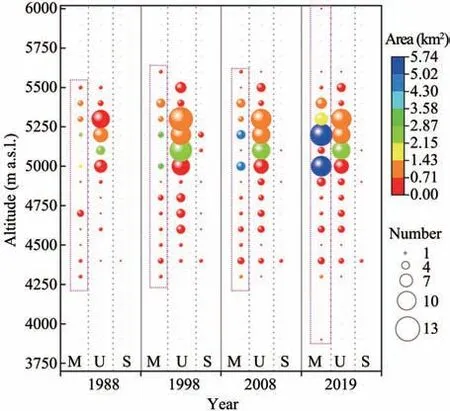
Figure 6 Variation of the number and area of moraine-dammed lakes(M),glacier-fed unconnected lake(U)and supraglacial lakes(S)in different altitude zones from 1988 to 2019
4.3 Historical GLOF events
Eight outbursts occurred at six glacial lakes with‐in the ZPR and GPR since 1935 (Table 1), with the lakes mapped in Figure 7.In 1935,the Taraco glacial lake burst due to the moraine dam collapse, which flooded 66,000 m2of farmland. Behind the Taraco glacial lake is a hanging glacier with a length of 1.5 km and an area of 2.32 km2, whose terminus is 0.3 km from the lake at present. Chenet al.(2007)predicted that it might burst again if the glacier surg‐es forward, but the scale and damage will not be as large as in 1935.The Cirenmaco glacial lake, located in the upper reaches of the Zhangzangbo gully, burst in 1964 and again in 1981. The flood of 1981 out‐burst killed more than 200 people in Nepal and de‐stroyed the friendship bridge and a hydropower sta‐tion. This event triggered widespread concern about the glacial lakes (Xuet al., 1988). Liet al. (2014)found that since the outburst of the Cirenmaco gla‐cial lake in 1981, many landslides have occurred.Xuet al.(1988) also showed that after the outburst of the Cirenmaco glacial lake in 1981, the flood eroded the loose bed material along its passage and formed torrents and debris flows, resulting in the collapse of banks and landslides in a stretch of more than 50 km along the Poiqu River and reactivating many parts of the ancient landslide near the Friend‐ship Bridge. On May 23 and June 29, 2002, two large-scale debris flows broke out in the Chongdui‐pu gully, where the Jialongco glacial lake is located.These debris flows damaged the China-Nepal High‐way, several hydropower stations and pastureland,causing a total loss of 1.1 million in US dollars(Chenet al., 2006). Chenet al.(2006) reported that the debris flows might be caused by the outburst flood of the Jialongco glacial lake, as they found that the daily temperature was 2.5 °C higher than the av‐erage at the time of the debris flows, and the lake's area decreased from 0.332 km2to 0.213 km2after its outburst triggered by an ice body falling into the lake.The outburst of the Gongbatongsha Tsho glacial lake on July 5,2016, eroded the major river channels in the lower river valley (Cooket al., 2018), and damaged the Bhotekoshi hydropower station and China-Nepal highway, causing economic losses of about 70 million in US dollars (China Science Daily,Nieet al., 2018). The survey results by Chengdu Mountain Disaster and Environmental Research In‐stitute of the Chinese Academy of Sciences indicat‐ed that the outburst of the Gongbatongsha Tsho gla‐cial lake was mainly due to continuous heavy precip‐itation that raised the lake's water level. After the outburst, the flood was transformed into an extremely large debris flow with a peak discharge of 4,000 m3/s.The outburst of the Longda Tsho and Zanaco glacial lakes on August 25, 1964 and June 7, 1995, resulted in ice avalanches and landslides and destroyed downstream roads and villages (Nieet al., 2017,2018).At present, however, the Longda Tsho glacial lake area is only 0.06 km2and is far away from the mother glacier. Therefore, it does not have enough material sources to expand. And the Zanaco glacial lake is almost dry based on Sentinel-2 remote sens‐ing image obtained in 2019 and hence, no longer poses a threat.
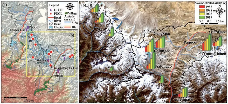
Figure 7 Spatial distribution of potentially dangerous glacial lakes.(a)Location of PDGLs in the ZPR and GPR.(b)Volume change of PDGLs between 1988 and 2019(Note:the volume of Gangxico and Galongco is reduced by ten times in(b)to fit in the graph)
4.4 Glacial lake potential risk assessment
There are, 40 glacial lakes with an area of >0.1 km2resided two ports region in 2019. Allenet al.(2019)identified 30 most dangerous glacial lakes on the Qinghai-Tibet Plateau.Among them, 67% or 20% are located within the ZPR and GPR.This study eventual‐ly identified eleven PDGLs according to the criteria in Table 3 and historical outburst events (Table 1) and listed them in Table 5. Although the number of PDGLs identified may different due to the different methods and indicators used, the considerations are the same for very dangerous lakes such as the Ciren‐maco and Galongco. Glacial lakes connected to gla‐ciers tend to expand substantially to pose a threat to downstream areas. The 3-D views from Google Earth confirm that these eleven PDGLS are nearly in con‐tact with their mother glaciers.Abundant glacial melt‐water supply has allowed them to expand rapidly in the past 30 years.Most lakes grew by over 150%with some lakes(i.e.,Nos.1,9 and 10,Figure 7a)by great‐er than 500%. Figure 7 illustrates the spatial distribu‐tion of PDGLs and historical GLOF events. Note that the water volume change of each lake was estimated by using empirical formulae.
Continuous time-series mapping of PDGLs illustrat‐ed in Figure 8 shows that the Galongco(5.36±0.16 km2)and the Gangxico (4.59±0.12 km2)have the largest ar‐eas, followed by the Jialongco (0.61±0.04 km2) and the Youmojanco (0.58±0.05 km2). All lakes expand‐ed by over 100%, except for the Gangxico, which al‐so has the lowest growth rate. In contrast, the Ji‐alongco, lakes No. 9 and No. 10 grew the most.Lakes No. 7, No. 8 and No. 11 were formed after 1990, and all showed a continuous expansion. The maximum possible peak discharge for each PDGL was estimated by using the empirical formulas based on lake volume (Popov, 1991).The trend of the peak discharge between 1988 and 2019 is displayed to the right of each lake displayed in Figure 8. It should be pointed out that the peak discharge provided in this study is only a rough estimate due to the nature of the empirical formulas. Nevertheless, these data can provide some reference for policymakers to plan long-term risk-reduction strategies. Considering cli‐mate change and glacier dynamics, the future flood peak discharge of some lakes may far exceed the historical one.
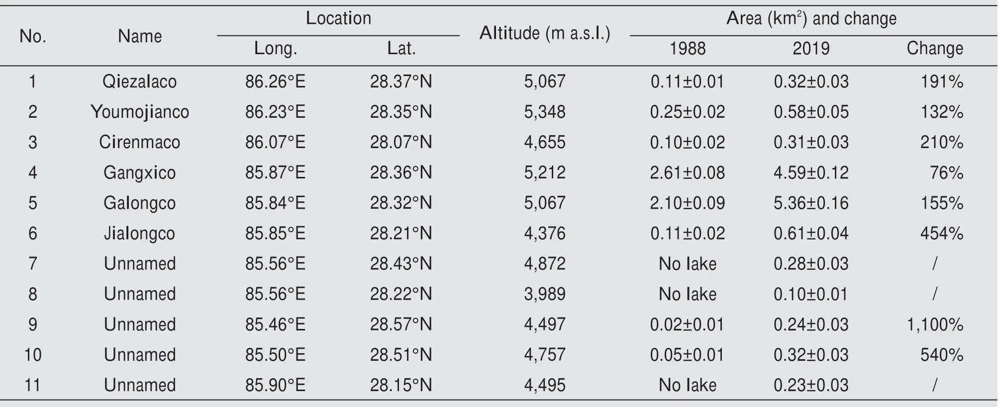
Table 5 Information and statistics of the PDGLs in the ZPR and GPR
Two out of the eleven PDGLs experienced four outbursts in the past few decades, namely the Ciren‐maco and Jialongco glacial lakes (Table 1).Although the expansion of the Cirenmaco and Jialongco stopped after 2010,danger still exists.The current ar‐ea of Cirenmaco is 0.31 km2based on the remote sensing image. This comparison implies that its cur‐rent volume may cause a similar disaster of 1981 if it bursts again. Field geomorphic analysis shows that the Cirenmaco is prone to GLOFs as it is under the impact of mass movements and ice and snow ava‐lanches, and the melting of the dead ice in the mo‐raine can lower the dam height (Wanget al., 2015).Besides, the tongue of the mother glacier of the Ci‐renmaco—the Amaciren Glacier—has a steep slope over 45° with densely distributed crevasses; it is ex‐tremely unstable and prone to ice calving/avalanche with rising temperatures (Wanget al., 2015). The Ji‐alongco had two outbursts in different months of 2002 due to the overtopping of the damming mo‐raines caused by an ice avalanche. The glacial lake is in direct contact with its mother glaciers and is fed by the glacier tongues located on steep slopes behind the lake.Under climate warming,the Jialongco could burst again due to ice avalanching from the steep glacier tongues.
The Gangxico and Galongco glacial lakes are the two PDGLs with the largest areas,which can be attrib‐uted to the topographic controls of the lake basin.They slowly expanded since 2010 and are projected to reach their maximum sizes soon. The tongues of their mother glaciers extends directly into the lakes,which drain from underneath. Since studies have shown that glaciers with their tongues extended into glacial lakes melt relatively quickly (Keet al., 2020),there is a high possibility for the glacier tongues to melt, fracture, and fall into the lake, thereby increas‐ing the risk of lake outburst. For their large areas and hence high peak discharge, the consequences of their outburst are unimaginable, and therefore, warrants continuous attention and consideration of proactive risk reduction plans.
The Qiezalaco,lake No.7 and lake No.8 continue to grow at a high rate. Among them, the Qiezalaco has the largest area and drains from underneath. It is also prone to ice and snow avalanches due to the steep tongue of its mother glacier. Lake No. 7 is a new supraglacial lake formed after 1990 and has no outlet.As the glacier retreats, the lake can continue to advance rapidly.It may eventually become a morainedammed lake with a large storage capacity after the glacier tongue retracts. Lake No. 8 was formed after 2010 with a relatively small area presently. Neverthe‐less, it has sustained a high expansion rate under the constant supply of glacial meltwater and is expected to soon become a large lake. Considering the nearest village located less than 500 m away from the lake,lake No.8 is potentially dangerous.
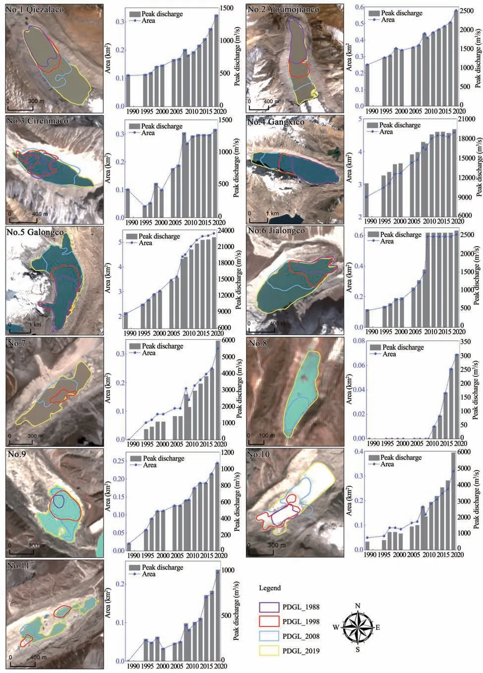
Figure 8 Variation of the area and peak discharge of the PDGLs in the ZPR and GPR from 1988 to 2019
The potential dangers of the Youmojianco, and lakes No. 9 through 11 will increase in the future, as shown in Figure 8. Future glacial lakes were detected in the modeled glacier-bed topography, implying that these lakes will continue to expand until reaching their maximum topographically-controlled extents.The linear growth rates of these four PDGLs between 1988 and 2019 were compared to estimate the time for the lakes to expand to the greatest extent in the fu‐ture. The results show that theoretically, the Youmoji‐anco will continue to expand until reaching its maxi‐mum topographically-controlled extent in 2064, and lakes No. 9 through 11 will reach their maximum ex‐tents in 2045, 2047 and 2052, respectively. Of course,the actual time frame may change as the expansion rate may change due to factors such as climate change.
5 Discussion and Perspectives
5.1 Response of Glacial Lakes to Climate Change
The glacial lake is a sensitive indicator of climate change (Yao and Zhu, 2006). Climate change, includ‐ing increased precipitation, reduced evaporation, and warming and humidification, can all cause the glacial lake to expand.The temperature in the central Himala‐yas has increased significantly since the 1960s. For example, the warming rate observed at the Nyalam station was 0.024 °C/a between 1967 and 2017 (Zhanget al., 2009).Temperature data from the nearest mete‐orological stations in Tingri County also show the mean air temperature increased by 0.035 °C/a between 1988 and 2015 (Jianget al., 2018). Studies elsewhere also confirmed that rising temperature may accelerate glacier melting (King and others, 2017; Wanget al.,2017). Glacier retreat driven by climate warming pro‐vides the necessary space for the formation and expan‐sion of the glacial lake,while continuous glacier melt‐ing directly promotes its expansion. Therefore, rising temperature greatly improves the conditions for the development of glacial lakes and increase the proba‐bility of GLOF in the ZPR and GPR. Precipitation is another crucial aspect of climate change. The annual precipitation observed at both Nyalam and Tingri sta‐tions has remained stable with a negligible rate of 0.28 mm/a and ?0.76 mm/a, respectively (Zhanget al.,2009;Jianget al.,2018).Yaoet al.(2012)also re‐ported that the precipitation for the entire Himalayas over the past few decades decreased. This trend sug‐gests that glacial meltwater supply has substantially contributed to the expansion of the glacial lake.
5.2 Modeled Predicted Future Glacial Lakes
Previous research predicted that by the end of the 21st century, temperatures in the Asian high mountain regions would rise by 2.1±0.1°C,and global tempera‐tures were expected to increase by 1.5 °C (Kraaijen‐brinket al., 2017). In this scenario, approximately half of the glaciers in the central Himalayan will disappear(Kraaijenbrinket al., 2017). As demonstrated for the Poiqu River Basin, the projected loss of glacier mass will almost certainly be associated with glacial lake ex‐pansion and, consequently, escalated threat to villages downstream (Zhanget al., 2019). Therefore, the possi‐ble location of future glacial lakes and the maximum topographically-controlled extents of the existing gla‐cial lakes in the ZPR and GPR were simulated to pro‐vide references for decision-makers to consider longterm planning and GLOF risk reduction strategies.
The glaciers with a size greater than 2 km2in the ZPR and GPR cover a total area of 626 km2according to RGI 6.0. 1,177 overdeepenings were detected in the modeled glacier-bed topography, and they have a mean area of 0.11 km2and a mean volume of 5.64×10⁹m3.Among them, 113 are larger than 0.01 km2, covering a total area of 11.88 km2and having a total volume of 6.37×10⁹m3.As shown in Figure 9a, these overdeepen‐ings, mostly distributed at the glacier terminus, are re‐garded as new glacial lakes when they are filled with meltwater rather than sediments due to glacier retreat.Figures 9c and 9d show the two largest glacial lakes,which are predicted to have a maximum water storage ca‐pacity of 1.08 km3and 0.60 km3, respectively, based on the glacier bed topography. A total of 88 potential new glacial lakes with an area less than 0.1 km2were identi‐fied within the ZPR and GPR. Table 6 lists the 16 lakes that are larger than 0.2 km2, and Figure 9a depicts their locations. Key quantification variables, including the ar‐ea,depth and volume,were calculated based on the Zon‐al Statistics Tool provided in ArcGis software version 10.7. However, other morphometric properties of the overdeepenings,such as length and width,are difficult to define(Pattonet al.,2015)and not included in this study.
6 Conclusions
This study mapped the glacial lakes larger than 0.01 km2in the Zhangmu and Gyirong port regions in the central Himalayas based on the remote sensing im‐ages and analyzed their change in the period of 1988 to 2019. A comprehensive assessment for potentially dangerous glacial lakes was provided. In addition, the glacier-bed topography model was used to predict fu‐ture glacial lakes. In 2019, 180 glacial lakes above 3,900 m a.s.l.accounting for a total area of 26.23 km2were identified in the study area,including five supra‐glacial lakes, 65 moraine-dammed lakes, and 110 gla‐cier-fed unconnected lakes. From 1988 to 2019, the glacial lakes in the Zhangmu and Gyirong port re‐gions underwent a process of "expansion", with their number increased by 169% and their area enlarged by 95%. Among them, moraine-dammed lakes show the most significant expansion trend.
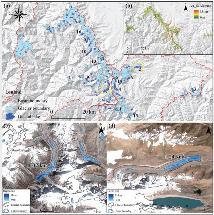
Figure 9 Modeled predicted future glacial lakes.(a)Distribution of the predicted 16 future glacial lakes in the ZPR and GPR.(b)Distribution of the ice thickness from Farinotti et al.(2019).(c)and(d)The two largest lakes in the basin.Yellow rectangles in Figure(a)show the position of the two largest lakes

Table 6 Statistics for the large glacial lakes(≥0.2 km2)in the ZPR and GPR predicted by glacier-bed topography model.
Compared with the Gyirong port region, the Zhangmu port region is more prone to GLOFs. While four PDGLs were identified in the Gyirong port re‐gion,seven PDGLs were found,and four outbursts oc‐curred in two glacial lakes within the Zhangmu port region. Abundant glacial meltwater supply has prompted them to expand rapidly in the past 30 years.Results show the Cirenmaco is still extremely prone to overtopping due to ice avalanches or the melting of dead ice in the dams. For other large lakes, such as the Jialongco, Gangxico and Galongco, because their monther glacier tongues extend into the lake, ice ava‐lanches may likely cause the lake to burst besides selfdestructive failure.
The potential dangers of the Youmojianco and lakes Nos. 9, 10 and 11 will increase in the future.Theoretically, the Youmojianco glacial lake will con‐tinue to expand until reaching its maximum topo‐graphically-controlled extent in 2064, and lakes Nos.9, 10 and 11 will reach their maximum extents in 2045, 2047 and 2052, respectively. In addition, the glacier-bed topography model predicts that 113 new glacial lakes with a size larger than 0.01 km2, a total area of 11.88 km2and a total volume of 6.37×10⁹m3will form in the basin by the end of the 21st century.Due to global warming, the glacial lakes in the study area will continue to expand in the short term,and the risk of GLOFs will increase accordingly.
Reliable risk assessment results are an essential scientific basis for proper response to GLOF. How‐ever, due to the high altitude and poor accessibility,glacial lake observation data is scarce, and the study of GLOFs is relatively weak. Our understanding of the mechanism of GLOF is still inadequate, which,to a certain extent, limits the reliability of the glacial lake disaster risk assessment. In the future, it is nec‐essary to strengthen research on the development trend of glacial lake disasters and risk assessment methods and technologies. Satellite remote sensing technology can be combined with field observation systems for the monitoring and early warning of highrisk glacial lakes. This will help enhance the adapt‐ability and resilience of local communities to glacial lake disasters and reduce disaster losses and negative impacts.
Acknowledgments:
This work is supported by the Second Tibetan Plateau Scientific Expedition and Research Program (STEP,Grant No. 2019QZKK0208), the Innovation Fund Designated to Graduate Students of Yunnan Universi‐ty (Grant No. 2020Z47), the National Natural Science Foundation of China (Grant No. 41761144075), and the Research Seed Fund for Talents of Yunnan Univer‐sity (No. YJRC3201702). In addition, this study is mainly designed by MiaoMiao Qi and ShiYin Liu.Mi‐aoMiao Qi collected the data, processed the remote sensing images and prepared the first draft. ShiYin Liu checked and revised the manuscript, and provided suggestions during manuscript preparation. YongPeng Gao discussed and commented on the manuscript and helped with data collection.
 Sciences in Cold and Arid Regions2020年6期
- Sciences in Cold and Arid Regions的其它文章
- Guidelines to Authors
- Characteristics and changes of permafrost along the engineering corridor of National Highway 214 in the eastern Qinghai-Tibet Plateau
- Glacier changes in the Qaidam Basin from 1977 to 2018
- Thickness estimation of the Longbasaba Glacier:methods and application
- Spatial distribution of supraglacial debris thickness on glaciers of the China-Pakistan Economic Corridor and surroundings
- Manifestations and mechanisms of mountain glacier-related hazards