
Impact of environmental change on runoff in a transitional basin:Tao River Basin from the Tibetan Plateau to the Loess Plateau, China
2019-06-11 06:20:08SUNLongWANGYueYangZHANGJianYunYANGQinLiBAOZhenXinGUANXiaoXiangGUANTieShengCHENXinWANGGuoQing
SUN Long, WANG Yue-Yang, ZHANG Jian-Yun, YANG Qin-Li, BAO Zhen-Xin,GUAN Xiao-Xiang, GUAN Tie-Sheng, CHEN Xin, WANG Guo-Qing,*
a State Key Laboratory of Hydrology-Water Resources and Hydraulic Engineering, Nanjing, 210029, China
b Institute of Hydrology and Water Resources, Hohai University, Nanjing, 210098, China
c Hydrology Bureau, Ministry of Water Resources, Beijing, 100053, China
d College of Geographical Sciences, Nanjing University of Information Science and Technology, Nanjing, 210044, China
e Research Center for Climate Change, Ministry of Water Resources, Nanjing, 210029, China
f School of Resources and Environment, University of Electronic Science and Technology of China, Chengdu, 611731, China
Abstract Quantification of the impacts of environmental changes on runoff in the transitional area from the Tibetan Plateau to the Loess Plateau is of critical importance for regional water resources management.Trends and abrupt change points of the hydro-climatic variables in the Tao River Basin were investigated during 1956-2015.It also quantitatively separates the impacts of climate change and human activities on runoff change in the Tao River by using RCC-WBM model. Results indicate that temperature presented a significant rising trend (0.2 °C per decade) while precipitation exhibited an insignificant decreasing trend (3.8 mm per decade) during 1956-2015. Recorded runoff in the Tao River decreased significantly with a magnitude of -13.7 mm per decade and abrupt changes in 1968 and 1986 were identified. Relative to the baseline period(1956-1968), runoff in the two anthropogenic disturbed periods of 1969-1986 and 1987-2015 decreased by 27.8 mm and 76.5 mm,respectively,which can be attributed to human activities (accounting for 69%) and climate change (accounting for 31%). Human activities are the principal drivers of runoff reduction in the Tao River Basin.However,the absolute influences on runoff reductions by the both drivers tend to increase, from 7.7 mm in 1969-1986 to 24.4 mm in 1987-2015 by climate change and from 20.2 mm to 52.2 mm by human activities.
Keywords: Climate change; Human activity; Runoff change; RCCC-WBM model; Runoff naturalization; Attribution analysis; Tao River Basin
1. Introduction
In the context of changing environment, hydrologic cycle as one of the most sensitive and direct sectors,has been highly influenced by global warming and intensive human activities(IPCC, 2013; IPCC, 2014; Desta et al., 2018; Hu et al., 2018;Jung and Kim,2018;Gildas et al.,2018).As a result,recorded runoff has been declining for rivers in arid or semi-arid regions(Wang et al., 2013; Giuntoli et al., 2013), while flooding has been aggravated for rivers in humid areas (Wu and Huang,2015; Zope et al., 2015). Hydrological response to climate change and human activities has been one of the main research themes of Panta Rhei-Everything Flows, the New Scientific Decade 2013-2022 of International Association of Hydrological Sciences(IAHS)(Montanari et al.,2013),while would benefit to water resources management on both global and regional scales.
The Tibetan Plateau,known as the third pole and sources of major rivers for the East Asia and the Southeast Asia,is one of the most sensitive areas to climate change(Walter et al.,2010;Li et al., 2013; Su et al., 2016). The Tibetan Plateau experienced wet conditions in the 1980s,dry conditions in the 1990s and wet conditions again after 2002 (Yang et al., 2014). In response to climate change, runoff in the Tibetan Plateau has exhibited similar change pattern that increase in the 1980s and decrease in the 1990s. However, runoff after 2002 did not show increase trend even precipitation has increased. Studies indicate that runoff changes in the Tibetan Plateau spatially varied (i.e., increase in central Plateau and declines in southern, eastern, and western Plateau), which can be attributed to variations in precipitation amount and spatial distribution(Lan et al., 2014; Wang et al., 2017b; Yang et al., 2014). Investigating the impacts of climate change and anthropogenic activity on runoff change of the Three Rivers Headwater Region in the Tibetan Plateau, Jiang et al. (2017a) found runoff slightly decreased in the headwater of Yangtze River and increased in the headwater of the Yellow River from 1956 to 2012 with an abrupt change happening in 1989. Climate change especially for precipitation reduction during 1990-2012 is the dominant contributor to runoff change in the Three Rivers Headwater Region, accounting for 90% (Jiang et al., 2017b).
The Loess Plateau, situated in the middle Yellow River Basin with arid and semi-arid climate, have experienced soil conservation projects since 1970s (Zhang et al., 2008) and global warming(Bao et al.,2019).In recent decades,runoff in the Loess Plateau has dramatically decreased and the number of zero-flow days has increased(Li et al.,2018).Its hydrologic response to soil conservation measures and climate change has attracted much attention. For instance, Bao et al. (2019)attributed runoff change in the middle Yellow River Basin to climate change and land use change. They concluded that relative to natural runoff in 1956-1979, human activities and land use change accounted for 75.8% and 75.5% of runoff reduction in 1980-2000 and in 2001-2016, respectively.Eleven catchments in the Loess Plateau were selected to investigate runoff response to land use change, including afforestation, terracing,etc. The results indicate annual runoff decreased in all eleven catchments and land use changes were identified as dominant driving factors for runoff reduction in eight out of eleven catchments(Zhang et al.,2008).In the Wei River Basin, the contribution of human activities to runoff reduction has increased from 59% in 1970-1989 to 63% in 1990-2010 (Wu et al., 2017; Chang et al., 2015). Li et al.(2007) pointed out that soil conservation measures accounted for 87%of the runoff declining in the Wuding River Basin.Besides, Wang et al. (2016) found that human activity and climate change contributed 60.6% and 39.4% to the total runoff reduction in the Xinshui River on the Loess Plateau,respectively. Based on the previous studies, a general conclusion can be drawn that human activity is the dominant driving factor for runoff decline in the Loess Plateau and its effect even became stronger in recent decade.
Diverse methods have been proposed for runoff attribution analysis, mainly including three categories: diagrammatizing methods (e.g., Budyko curves, modified double-mass curves), numerical calculation-based methods(e.g., elasticity, sensitivity, hydrologic models), and field data-based methods (Dey and Mishra, 2017; Yang et al.,2019; Shao et al., 2015). Specifically, the field data-based method is often limited by the availability of long-term observations of paired experimental catchments (Yang et al.,2019). In the diagrammatizing methods, the introduced parameters for actual evaporation estimation are difficult to obtain (Xu et al., 2014). In contrast, numerical calculation based methods, particularly for hydrological model-based approaches, have been widely applied in runoff attribution studies since they take hydrological processes into account(Zhai and Tao, 2017).
Numerous studies of attribution for runoff change in the Tibetan Plateau and the Loess Plateau have been conducted by adopting the above mentioned methods. In general,climate change dominates runoff changes in the Tibetan Plateau while human activity is the main factor for runoff reduction on the Loess Plateau (Su et al., 2016; Zuo et al.,2016; Li et al., 2017). However, attribution study of hydrological regime changes in the transitional area from the Tibetan Plateau to the Loess Plateau,where the Tao River basin located, is rarely investigated. For instance, Chang et al.,(2019) found that runoff in the upper Tao River significantly decreased by 29.3% in 1988-2014 relative to that in 1956-1987. However, quantitative attribution was not conducted. Xiong (2018) analyzed the reasons behind runoff decline in the Tao River Basin in 1996-2015, and the impacts of climate change and human influences were discussed in a qualitative manner.
The Tao River is one of major branches of upper Yellow River, situates in the transitional area from the Tibetan Plateau to the Loess Plateau. The Tao River plays essential role in water resources supply to central Gansu province,located in the arid and semi-arid area in Northwest China. It is of significance to investigate impact of environment change on runoff in the Tao River for enriching hydrologic responses from the Tibetan Plateau to the Loess Plateau and for providing scientific supports to water resources management.
Therefore, in this study, we aim to quantitatively assess the impacts of climate change and human activities on runoff change in a transitional area between the Tibetan Plateau and the Loess Plateau by using hydrological simulation approach. Taking the Tao River catchment as a case, the objectives are to investigate the variation features of hydro-meteorological variables of the study area under a changing environment, and to separate the impacts of climate change and human activities on runoff change in the Tao River quantitatively. The findings about how and why does runoff change in the Tao River would provide scientific support for regional adaptive water resources and basin management.
2. Data and methods
2.1. Study area
The Tao River (with a length of 673 km) is a first level tributary of the Yellow River (Fig. 1), originating from the Riyue Mountain.Shaped like L,it flows eastward after turning left at Minhe county and running north into the Liujiaxia Reservoir. The Tao River Basin (101.87°-104.32°E,34.05°-35.92°N)has a drainage area of 25,527 km2,97.3%of which is located in Gansu province.
The Tao River can be divided into three sections.The upper reach is above Minhe county and runs through plateau grassland. The middle reach is from Minhe county to Tao county,where forest vegetation is abundant. The low reach is below Tao county, which has sparse vegetation and serious soil erosion due to its location on the Loess Plateau.
The Tao River Basin is highly influenced by a subtropical climate with obvious vertical change because of the difference in elevation. Mean annual temperature ranges from 2.3 to 7.0°C while annual precipitation varies from 312-613 mm.The Tao River Basin is short of water resources due to relatively high annual pan evaporation, ranging from 1200-1700 mm.
The Tao River consists of seven major tributaries, among which four are on the left side and three are on the right.There are 36 rain gauges and 9 meteorological stations available within or around the basin. The outlet hydrometric station(Hongqi station) controls a drainage area of 24,973 km2.
Daily hydrological data gauged at the Hongqi station and precipitation data recorded at the 36 rain gauges from 1956 to 2015 were collected from the Hydrology Bureau of the Ministry of Water Resources,China.Daily precipitation,temperature,and pan evaporation data gauged at 9 meteorological stations were collected from the China Meteorological Administration(CMA,http://cdc.cma.gov.cn). Monthly precipitation, mean temperature and pan evaporation over the Tao River Basin were calculated by using the Thiessen polygons method (Liu, 2018). In order to understand human activities in the Tao River Basin,Soil and Water Conservation Bulletin Series of the Yellow River Basin were collected from the Yellow River Conservancy Committee,Ministry of Water Resources,China.
2.2. Attribution analysis for runoff variation
This study uses a hydro-simulation-based attribution analysis approach proposed by Wang et al. (2006) to quantify the contributions of climate change and human activities on runoff change. The approach assumes runoff change is induced by two independent drivers:climate change and human activities.The detailed steps of attribution analysis are illustrated as follows (Fig. 2):
(1) Determination of natural period and impact periods:The abrupt change points of the data series were identified by the Mann Kendall test (Pal et al., 2019) and the Sequential Cluster Analysis (Chen et al., 2011; Wang et al., 2016; Shao et al., 2019; Din and Shao, 2020).Based on the detected change points,the data series can be divided into two or more segments. The segment before the first abrupt change point was regarded as the natural period or baseline period,and the other segments were treated as human-disturbance periods with a relatively higher anthropogenic influence.
(2) Quantification of runoff change attribution: The difference between the recorded runoff and the naturalized runoff in human-disturbance periods is regarded as human-induced runoff change. The differences between runoff in the natural period and naturalized runoff in the impact periods are regarded as climate-induced runoff change.

Fig.1.The river system and locations of hydro-meteorological stations of the Tao River(deep dark grey area on the left figure is the Tibetan Plateau,the dark grey area in the Yellow River Basin is the Loess Plateau).

Fig. 2. Framework of attribution analysis for runoff change.
2.3. RCCC-WBM model
The RCCC-WBM model is a simplified water balance model developed by the RCCC team (Research Center for Climate Change of Ministry of Water Resources, RCCC;http://rccc.nhri.cn/). The model has been applied to hundreds of climatically different global catchments(Wang et al.,2014).The model's structure is shown in Fig. 3.
The model's inputs include average precipitation, temperature, and pan evaporation over a basin. Recorded discharges gauged at the outlet hydrometric stations are used to calibrate model parameters. Four model parameters need to be calibrated for estimating yield of surface flow (QS),ground flow (QG), snowmelt flow (QSN) and soil moisture.The model runs by monthly step (Wang et al., 2014). The model includes two state variables: snow storage and soil moisture. The initial value of the snow storage is usually set as 0 and the initial soil moisture is set as half of the maximum soil moisture. To prevent the initial values of state variables from affecting the hydrological simulation,the first year of data series was usually taken as a warming period.
The Nash and Sutcliffe efficiency criterion (NSE) and the relative error of volumetric fit(RE)are employed as objective functions to calibrate the model parameters. A hydrological model that performs well will have a NSE close to 1 and a RE approaching 0 (Nash and Sutcliffe, 1970).
3. Results and discussion
3.1. Variations of hydro-meteorological variables
3.1.1. Trends of hydro-meteorological variables
Annual mean temperature shows a significant rising trend with a rate of 0.20°C per decade(Fig.4a),which is lower than that of the Tibetan Plateau average of 0.34°C per decade(Kuang and Jiao,2016).However,a big leap of the temperature series occurring in 1996 can be visually found. The annual mean temperature in 1996-2015 is 0.95°C higher than that in 1956-1985. Annual precipitation and pan evaporation both exhibit declining trends with rates of 3.8 mm per decade and 13.5 mm per decade, respectively. As a result of changes in precipitation and temperature of the Tao River Basin, the recorded runoff gauged at the Hongqi station shows a significant decreasing trend of 13.7 mm per decade. It is also found the recorded runoff remains at a continuous low-level stage after the mid-1990s. The average runoff during 1996-2015 is only 73.9% of that in previous period (196 mm).
Table 1 shows that temperature presents significant rising trends on both annual and seasonal scales, with the highest rising rate occurring in winter (0.39°C per decade). Precipitation exhibits insignificant decreasing trends on annual and seasonal scales with the exception of winter, in which precipitation slightly increases (0.4 mm per decade) during 1956-2015. Significant reduction trends are detected for pan evaporation on annual and seasonal scales except for winter,in which pan evaporation increased insignificantly.The recorded runoff presents significant decreasing trends on both annual and seasonal scales except for winter.
3.1.2. Segmentation of natural period and anthropogenic impact periods
Previous studies indicate variation in precipitation dominates the fluctuation of the runoff series (Zhang and Wang,2007; Wang et al., 2016). In order to eliminate the effect of precipitation and effectively select natural period and anthropogenic impact periods from a hydrological series, we therefore detect the abrupt changes in annual runoff coefficient series by using a sequential cluster analysis,as shown in Fig. 5.
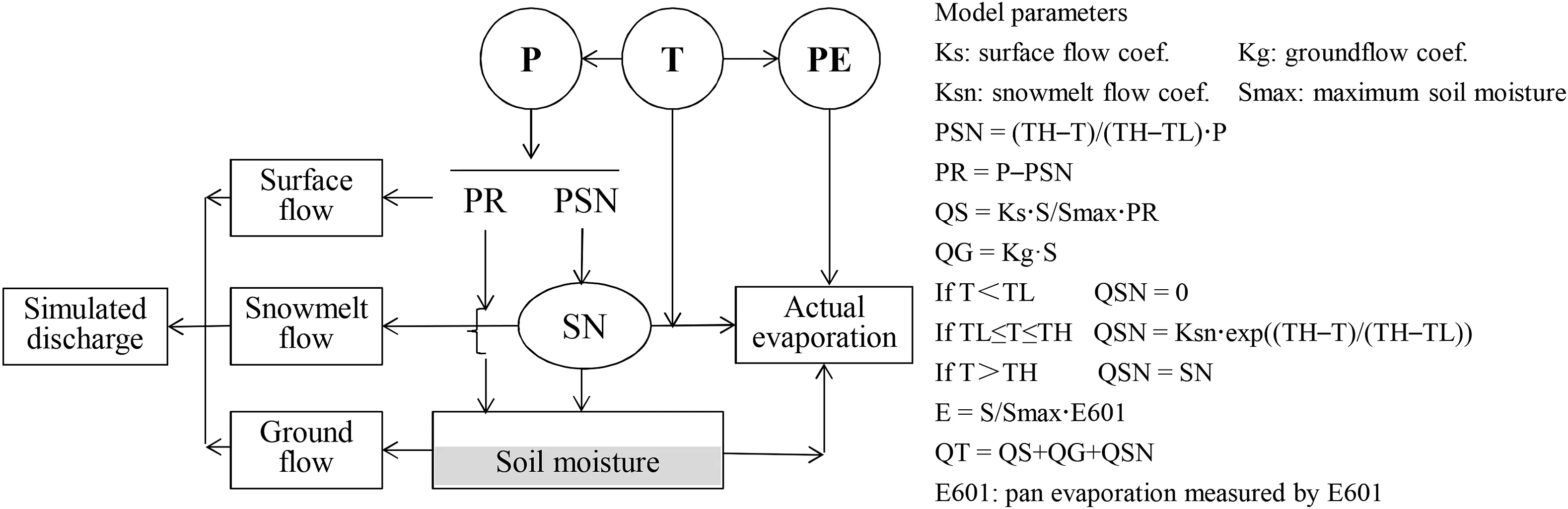
Fig. 3. Framework of the RCCC-WBM model (left) and its calculation principle (right) (source: Wang et al. (2014)).
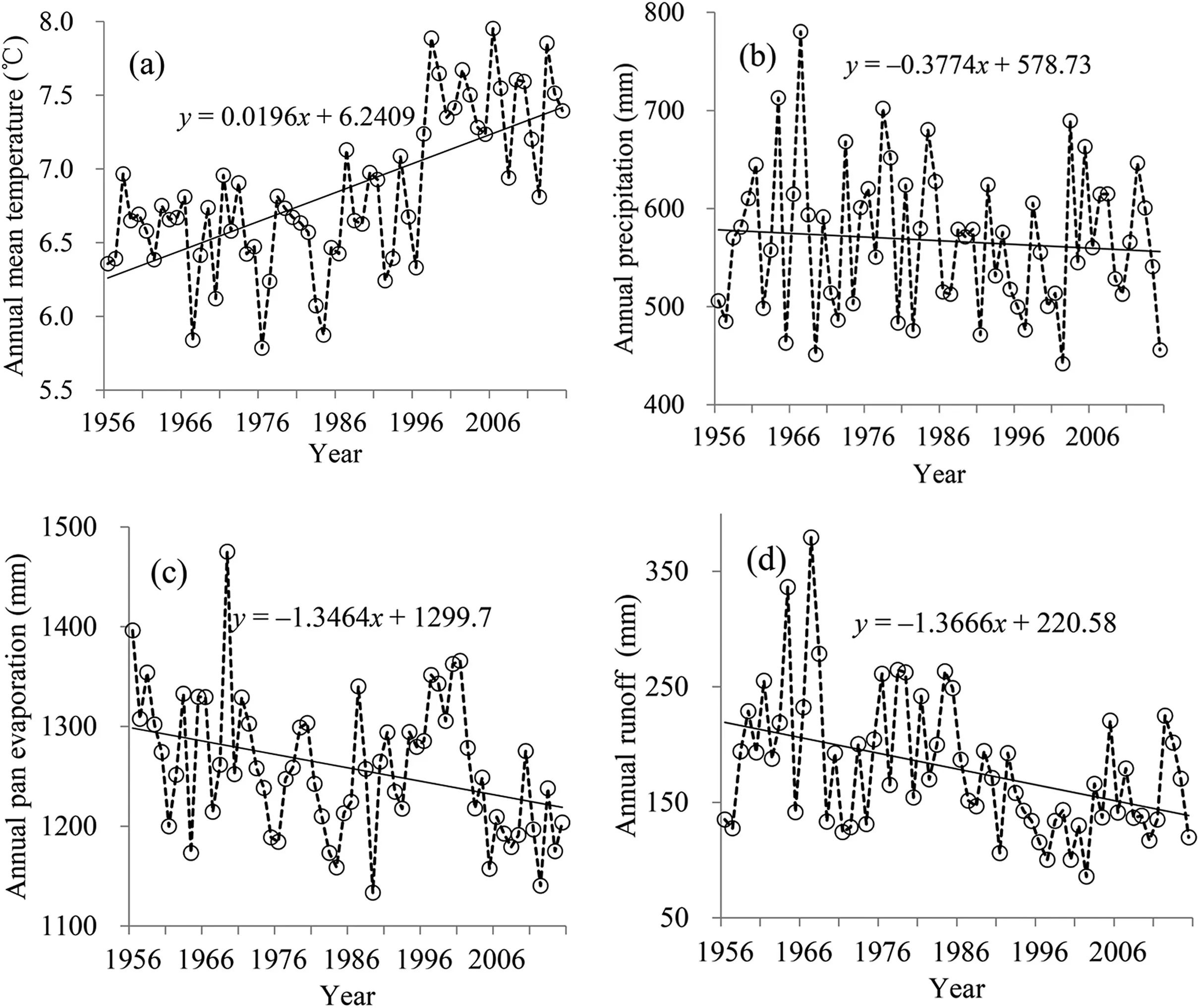
Fig.4.Variation of annual mean temperature(a),annual precipitation(b),potential evaporation(c),and runoff during 1956-2015 in the Tao River Basin,China.
Two low peak points were detected in the runoff coefficient series in 1986 and 1968 respectively,with the most significant abrupt change year of 1986. The average annual runoff coefficient in 1956-1968 is 0.38,and decreases to 0.34 and 0.27 in 1969-1986 and 1987-2015, respectively. Yellow River Conservancy Commission Year Book Series and the previous study conducted by Liu (2012) both indicated that soil and water conservation measures had been implemented in the Tao River catchment since the late 1960s for soil erosion control.It has been proofed that these human activities influenced stream flow substantially (Zhang et al., 2008). Thus, based on thedetected abrupt changes, the data series can be divided into three periods: natural period (1956-1968), moderate anthropogenic impact period (1969-1986), and intensive anthropogenic impact period (1987-2015).

Table 1 Linear trends in temperature, precipitation, pan evaporation, and runoff on annual and seasonal scales during 1956-2015.
The mean annual runoff in 1956-1968 is 223.7 mm and runoff in the two anthropogenic impact periods of 1969-1986 and 1987-2015 decreased by 12.3% and 33.9% respectively.During 1969-1986,runoff in June increases by 0.3 mm,while decreases from -5.8 mm to -0.4 mm in other months with a higher decreases occurring in May,July,and October.Relative to month runoff in 1956-1968,runoff in 1987-2015 received a higher decrease than that in 1969-1986, which decreased from -17.5 mm to -0.6 mm for all twelve months, with relatively high decreases occurring in the wet season from July to October (Fig. 6).
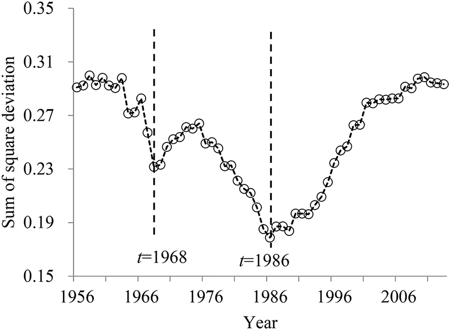
Fig. 5. Detection of the abrupt change in annual runoff coefficient series.
3.2. Model calibration and hydrological modeling for natural period
The data series of 1957-1965 was used to calibrate model parameters and that of 1966-1968 was employed to validate the RCCC-WBM model.The simulated discharges correspond well with the recorded discharges, with an underestimation of high discharges (Fig. 7). The model overestimates discharge for the first year which is probably due to the effect of initial values of state variables. The Nash and Sutcliffe efficiency criteria in the calibration and validation periods are 0.74 and 0.75 separately while the relative errors of volumetric fit are 3.3%and-4.2%.For the period of 1956-1968,the Nash and Sutcliffe efficiency criterion and relative error are 0.74 and-0.12%, respectively.

Fig. 6. Runoff changes in the two anthropogenic impact periods relative to baseline of 1956-1968.

Fig. 7. Monthly recorded and simulated runoff at the Hongqi station for 1956-1968.
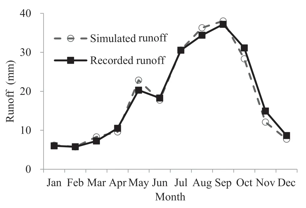
Fig. 8. Average seasonal patterns of the simulated and recorded runoff at the Hongqi station during 1956-1968.
The spring peak flow in May can be moderately simulated by the model (Fig. 8). Although the RCCC-WBM model underestimates peak discharges for some extreme high flows(Fig. 7), on average over the span from 1956 to 1968, it overestimates spring peak discharge and higher discharges in August and September. Runoff in October and November are also underestimated. In general, the mean simulated month discharges match well with the recorded ones for all months.The RCCC-WBM model performs well for the Tao River Basin, and it is qualified to naturalize runoff for the River Basin.
3.3. Attribution analysis
3.3.1. Runoff naturalization and attribution
The natural runoff series in the anthropogenic impact periods was simulated by using meteorological data in 1969-2015 to drive the calibrated RCCC-WBM model.It can be found that annual simulated runoff corresponds well with that recorded before 1968 (Fig. 9). The recorded runoff after 1968 is lower than the simulated runoff in the same period.The differences between the recorded and the simulated runoff in 1969-2015 reflect anthropogenic influence, and it is found a bigger difference occurred in period of 1987-2015.

Fig. 9. Recorded and simulated annual runoff series at the Hongqi station during 1956-2015.

Table 2 Impacts of climate change and human activities on runoff reduction in the Tao River Basin.
The recorded runoff in 1969-1986 and 1987-2015 fell by 27.8 mm and 76.5 mm relative to the baseline (Table 2).Both climate change and human activities lead to runoff reduction in the two anthropogenic impact periods of 1969-1986 and 1987-2015, and higher influences occurred in the second anthropogenic impact period. The absolute runoff reductions induced by human activities increased from 20.2 mm in 1969-1986 to 52.2 mm in 1987-2015 while climate-induced runoff reductions increased from 7.7 mm to 24.4 mm.Human activities account for 72.5% and 68.2% of the total runoff reductions for the two anthropogenic impact periods, and climate change contributes 27.5% and 31.8% of total runoff reduction for the two impact periods respectively. Human activity is a principal driver of runoff reduction in the Tao River Basin.
3.3.2. Impacts of climate change and human activities on seasonal pattern of runoff change
Climate change had a larger impact on runoff in the intensive anthropogenic impact period (1987-2015) than that in the moderate anthropogenic impact period (1969-1986)(Fig. 10a). Due to climate change, runoff changes in 1969-1986 range from-2.1 mm to 1.1 mm while that varies from -7.1 mm to 3.1 mm in 1987-2015. In the moderate anthropogenic period, ten months received runoff decrease except August and September, in which, runoff increased by 1.1 mm and 0.4 mm respectively. In the intensive anthropogenic impact period, runoff increases by 3.1 mm in June and decreased by 0.2-7.9 mm for the other months with relatively high reductions in August, September, and October. For the both anthropogenic periods, it could be found runoff increase in flood season months (e.g., August and September in 1969-1986 and June in 1987-2015), which is mainly due to increase in precipitation. For instance,precipitation in June in 1987-2015 increased by 6.5 mm relative to that in 1956-1967, which lead to 3.1 mm of runoff increase in this month. Runoff reduction in Fig. 10a is also associated to precipitation decrease. For example, precipitation in September in 1987-2015 increased by 11.8 mm relative to 1956-1967, correspondingly, a larger runoff decrease of 7.9 mm occurred in this month.
Fig.10b shows that human activities in the Tao River Basin increased runoff in the dry season and decrease runoff in the wet season. Due to anthropogenic influence, runoff decreased from May to September in 1969-1986, with the highest decrease of 13.7 mm occurring in August and increases in other months. In the second anthropogenic impact period of 1987-2015, the length of runoff decreases extended to nine months from February to October with higher decrease occurring from June to September. It also could be found that human activities implemented a larger influence on runoff in 1988-2015 than that in 1969-1987. Human-induced runoff changes in the both anthropogenic periods vary from-13.7 mm to 3.2 mm in 1969-1987 and from -15.4 mm to 2.7 mm in 1988-2015. Runoff reduction of over 10 mm only occurred in August during 1969-1987 and in four months from June to September during 1988-2015.
3.4. Discussion
3.4.1. Human activities in the Tao River Basin
Water conservancy projects, land use change, urbanization, agricultural irrigation and water pumping for domestic use, and other human activities could influence stream flow by changing runoff yield condition and regional hydrological cycle (Wang and Cai, 2010). Hydrological observations indicate that reservoirs and check dams have direct impacts on stream flow by storing water in reservoirs (Liu, 2012).Comparing to the bare slope land, terrace land could store 70%-92% of rainfall and thus decrease surface flow generating, and reforestation measures on slope land could decrease 40%-80% of surface flow with higher runoff decreasing rate for small and medium intensity rainfall events (Chen et al., 2004). The Tao River Basin has been implementing large-scale soil and water conservation activities such as building reservoirs and terracing land, reforestation and forbidding wasteland reclamation since the 1970s(Fig. 11).
Soil and water conservation measures have generally covered more areas,with a leap occurring in the mid-1980s for grassland and reforested land(Fig.11),which is in accordance with abrupt change in detection of the annual runoff coefficient series in Fig. 5. In 2015, the total regulated area of soil and water conservation is approximately 4530 km2, including 1187 km2of terraced land, 2116 km2of reforested land,561 km2of grassland, and a 104 km2ecological restoration area. There are 13 reservoirs with a total storage capacity of 40.14 million m3on the main stream of the Tao River, 48 check dams on the main tributaries, and 56,000 water cellars in the Tao River Basin (YRCC, 2016). Intensive human activities are the main reason for runoff reduction in the anthropogenic impact period after 1968.

Fig. 10. Seasonal runoff change due to climate change (a), and human activities (b) in the Tao River for 1969-1988 and 1987-2015 relative to baseline(1956-1968).

Fig.11.Variation of areas of terrace land,reforestation land and grass land in the Tao River Basin in 1972-2010.

Fig. 12. Relationships between annual runoff and precipitation over various periods.
3.4.2. Relationships between runoff and precipitation
Human activities can change the regional hydrological regime by altering the relationship between runoff and precipitation. Fig. 12 shows that annual runoff highly correlates to annual precipitation for the natural period (1956-1968,r = 0.877) followed by the moderate anthropogenic impact period (1969-1986, r = 0.779) and the intensive anthropogenic impact period (1987-2015, r = 0.617). The points in the natural period concentrate in the upper domain, while that for 1987-2015 is in the lower domain and the points in the second period are in the middle area (Fig. 12). Runoff yield in the natural period is higher than those in the anthropogenic impact periods even for the same precipitation.Therefore, human activities in the Tao River Basin have changed the relationship between runoff and precipitation and the runoff yield was reduced.
3.4.3. Climate change in the Tao River Basin
During the two anthropogenic impact periods of 1969-1986 and 1987-2015, climate change due to temperature rise and precipitation change leads to 27.5%and 31.8%of total runoff reduction.
Temperature rise in the intensive anthropogenic impact period (0.08-0.91°C) is much higher than that in the moderate anthropogenic impact period (0.02-0.51°C) (Fig. 13).Temperature rise can decrease runoff by increasing potential evaporation, actual catchment evaporation and vegetation transpiration. Changes in precipitation for both anthropogenic impact periods are generally in accordance to climate-induced runoff change shown in Fig. 10b. During 1969-1986, precipitation increased in six of the months with a higher increase(9.6 mm) occurring in August, however, increases in runoff only occurred in the two months of August and September.This may be probably due to the increases in evaporation induced by higher temperature rises.Similarly,in the intensive anthropogenic impact period, precipitation increased in four months with a highest increase (+6.5 mm) occurring in June;runoff increased (+3.1 mm) only in June; and approximately 50% of the precipitation increase was yield as runoff. The effect of temperature rise on runoff partly offsets the influence of increase in precipitation in June.
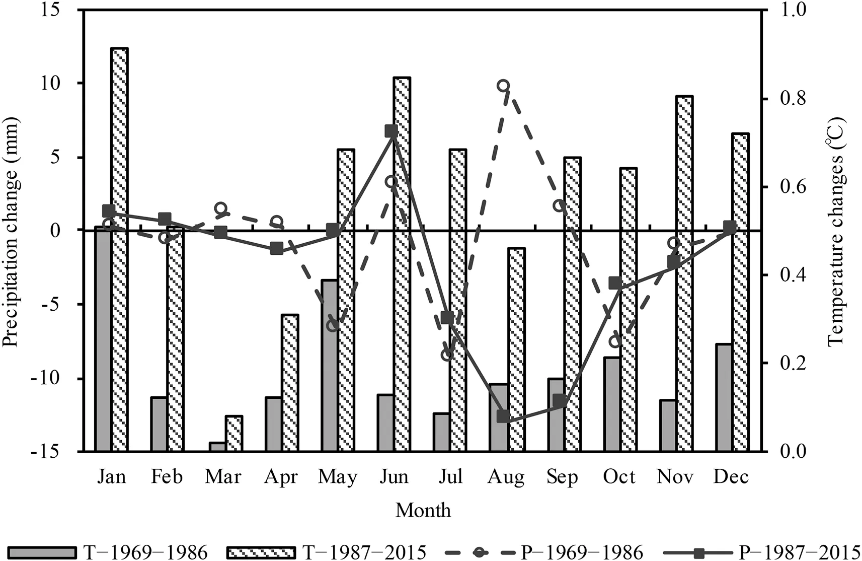
Fig. 13. Changes in mean monthly precipitation and temperature during the two anthropogenic impact periods relative to the baseline of 1956-1968.
3.4.4. Uncertainty of attribution analysis and further study
Although the RCCC-WBM model performs well on runoff simulation for the Tao River,the model cannot simulate hydrological process perfectly.Simulation errors always exist not only in historical discharge modeling but also in runoff naturalization in anthropogenic periods.Mathematical attribution methods can quantify the effects of climate change and human activities on runoff change, based on the assumption of perfect discharge simulation and naturalization. Due to simulation error, the quantified contributions of different drivers to runoff change should vary in a certain range rather than be a concrete value.
In this study, we category two drivers of runoff change,e.g.,climate change and human activities,and climate change mainly refers to change in climatic variables including temperature, precipitation, pan evaporation, on decadal scale,while human activities in this study mainly refer to water conservancy project construction, land use change, water intake for supporting industrial and agricultural development,etc., which is different to that defined by climatologists and meteorologists. In runoff attribution analysis method, we assume the two drivers are independent to each other. However, climate change could influence land use to some extent while human activities also exert a certain impact on local climate change. Although the interaction between climate and human activities is a local impact,and could be ignorable for a large scale river basin, the limitation of the methodology assumption will introduce uncertainty in attribution analysis result.
Hydrological responses to environmental change in the transitional area from the Tibetan Plateau to the Loess Plateau are much more similar to that of the Loess Plateau than the Tibetan Plateau. The main reason is that the Tao River Basin,like most catchments on the Loess Plateau, has been highly regulated by intensive anthropogenic activities which dominate the regional hydrological regime. In contrast, most basins on the Tibetan Plateau are less disturbed by human activities and climate change dominates hydrological variations.
Since temperature, precipitation and pan evaporation are principal elements influencing hydrological cycle(Wang et al.,2017a), and these were well considered in climate change in this study. However, radiation, sunshine duration, wind, air humidity, and other meteorological variables could influence hydrological regime to some extent by changing basin actual evaporation,and these elements were not taken into account in runoff attribution analysis. Meanwhile, human activities are also very complicated, which consist of various activities, so further study is needed to detect the influence of each type of human activity on runoff and identify the contribution of each driver to runoff change.
4. Conclusions
Temperature in the Tao River Basin presented a significant rising trend while precipitation exhibited an insignificant decreasing trend during 1956-2015. Recorded runoff at the Hongqi hydrometric station had a significant decreasing trend of 13.7 mm per decade.
Recorded runoff in the moderate (1969-1986) and intensive anthropogenic periods (1987-2015) decreased by 12.3%and 33.9% relative to that in the natural period with a higher decrease occurring in wet seasons.
Human activities accounted for approximately 69%of total runoff reduction while climate change's contribution was 31%for the both anthropogenic impact periods. Anthropogenic influence is a major driver to runoff change for the Tao River Basin. The absolute human-induced and climate-induced runoff changes in the intensive anthropogenic period are 32.0 mm and 16.7 mm higher than that in the moderate anthropogenic period respectively.
Seasonal pattern of runoff in the Tao River Basin were altered by the both drivers of climate change and human activities. Human activities in the Tao River Basin increased runoff in the dry season and decrease runoff in the wet season with a higher influence in wet season.
Conflict of interest
The authors declare no conflict of interest.
Acknowledgments
This study has been financially supported by the National Key Research and Development Programs of China(2016YFA0601501),the National Natural Science Foundation of China(41830863,51879162,41601025),and the Belt and Road Fund on Water and Sustainability of the State Key Laboratory of Hydrology-Water Resources and Hydraulic Engineering (2019). We appreciate Mr. Samantha Kierath, an Australian-born production journalist, for his kind assistance on English quality improving.Thanks also to the anonymous reviewers and editors.
 Advances in Climate Change Research2019年4期
- Advances in Climate Change Research的其它文章
- Sensitivity of the simulated CO2 concentration to inter-annual variations of its sources and sinks over East Asia
- China's long-term low carbon transition pathway under the urbanization process
- Impacts of degrading permafrost on streamflow in the source area of Yellow River on the Qinghai-Tibet Plateau, China
- Regional differences in global glacier retreat from 1980 to 2015
- Assessments of the Arctic amplification and the changes in the Arctic sea surface