
Improvement of wind field hindcasts for tropical cyclones
2016-09-07 07:31:37YiPanYongpingChenJiangxiaLiXuelinDing
Water Science and Engineering 2016年1期
Yi Pan,Yong-ping Chen,*,Jiang-xia Li,Xue-lin Ding
aState Key Laboratory of Hydrology-Water Resources and Hydraulic Engineering,Hohai University,Nanjing 210098,ChinabCollege of Harbor,Coastal and Offshore Engineering,Hohai University,Nanjing 210098,China
?
Improvement of wind field hindcasts for tropical cyclones
Yi Pana,b,Yong-ping Chena,b,*,Jiang-xia Lia,b,Xue-lin Dinga,b
aState Key Laboratory of Hydrology-Water Resources and Hydraulic Engineering,Hohai University,Nanjing 210098,China
bCollege of Harbor,Coastal and Offshore Engineering,Hohai University,Nanjing 210098,China
Available online 21 February 2016
Abstract
This paper presents a study on the improvement of wind field hindcasts for two typical tropical cyclones,i.e.,Fanapi and Meranti,which occurred in 2010.The performance of the three existing models for the hindcasting of cyclone wind fields is first examined,and then two modification methods are proposed to improve the hindcasted results.The first one is the superposition method,which superposes the wind field calculated from the parametric cyclone model on that obtained from the cross-calibrated multi-platform(CCMP)reanalysis data.The radius used for the superposition is based on an analysis of the minimum difference between the two wind fields.The other one is the direct modification method,which directly modifies the CCMP reanalysis data according to the ratio of the measured maximum wind speed to the reanalyzed value as well as the distance from the cyclone center.Using these two methods,the problem of underestimation of strong winds in reanalysis data can be overcome.Both methods show considerable improvements in the hindcasting of tropical cyclone wind fields, compared with the cyclone wind model and the reanalysis data.
?2016 Hohai University.Production and hosting by Elsevier B.V.This is an open access article under the CC BY-NC-ND license(http://creativecommons.org/licenses/by-nc-nd/4.0/).
Tropical cyclone;Parametric cyclone wind model;CCMP reanalysis data;Wind field hindcasts
1.Introduction
A tropical cyclone(usually referred to as a typhoon in the Western Pacific and a hurricane in the Eastern Pacific and the Atlantic)may cause significant storm surges and strong waves and poses a great threat to coastal areas.The accurate hindcasting of tropical cyclone wind fields is important in terms of reducing and preventing coastal disasters,e.g.,through the assessment of sea levee systems,the evaluation of wave conditions,and the optimization of protection strategies against future cyclones.
The parametric cyclone wind model,proposed in the 1960s(Jelesnianski,1965,1966;Russell,1968),has been widely used in the hindcasting of wind fields of tropical cyclones due to its simplicity and accuracy(Dube et al., 1985;Ginis and Sutyrin,1995;Lee,2008).Different parametric cyclone wind models have been proposed and used around the world for the hindcasting of tropical cyclones. Three tropical cyclone models in particular,proposed by Jelesnianski(1966),Holland(1980),and Knaff et al.(2007), respectively,have been commonly used in published studies. The Holland(1980)model was strongly recommended by the advanced circulation(ADCIRC)model research group(e.g., Mattocks et al.,2006).The Knaff et al.(2007)model,also known as the D09 model(DeMaria et al.,2009),was successfully applied in the hindcasting of many cyclone events (Pande et al.,2002;Mattocks et al.,2006;Xie et al.,2006; Mattocks and Forbes,2008;DeMaria et al.,2009;Sampson et al.,2013).In these models,the radius of maximum wind,which controls the eye diameter of the tropicalcyclone,is considered a key factor in determining the hindcasted wind fields.It can be estimated either through some empirical formulas(Graham and Nunn,1959;Knaff et al., 2007)or through the radii of several characteristic wind speeds(Xie et al.,2006;Gao et al.,2013).Although the cyclone wind models can reproduce the wind fields in the center area of the tropical cyclone,the modeled wind fields at a greater distance from the cyclone are not accurate enough, since the major factors that control wind fields farther away from the cyclone might be some other weather systems, rather than the tropical cyclone.
Long-term reanalysis wind data obtained from the data assimilation model have also been widely used for the hindcasting of the wind fields due to their accessibility and good accuracy.The data provided by the National Centers for Environmental Prediction(NCEP),the European Centre for Medium-Range Weather Forecasts(ECMWF),and the cross-calibrated multi-platform(CCMP)are the most commonly used reanalysis data.Those data have been widely used to solve ocean and coastal hindcasting problems(e.g.,Brenner et al.,2007;Lu¨et al.,2014; Moeini et al.,2010;Wu and Chiang,2007).However,previous studies have shown that the wind speeds near the center of the tropical cyclone obtained from the reanalysis data are generally lower than the actual values(Cavaleri and Sclavo,2006;Signell et al.,2005),and corrections are needed before use.
In this paper,some improvements in the hindcasting of wind fields for tropical cyclones are presented.Three commonly used cyclone wind models,proposed by Jelesnianski(1966), Holland(1980),and Knaff et al.(2007),respectively,were first used in this study to hindcast two typical tropical cyclones, i.e.,Fanapi and Meranti,which occurred in 2010.The performance of the three models for the hindcasting of cyclone wind fields is compared and discussed.As both the tropical cyclone model and the reanalysis data have their own limitations,i.e., the tropical cyclone model cannot reproduce the characteristics of the wind field far from the tropical cyclone center,and the reanalysis data tends to underestimate high winds,two modification methods are proposed to improve the accuracy of hindcasted wind fields.One is the superposition method,which superposes the wind field calculated from the tropical cyclone model on the reanalysis data,and the other is the direct modification method,which directly modifies the reanalysis wind speed around the tropical cyclone center,with an amplification factor that varies with the ratio of the measured maximum wind speed to the reanalyzed value as well as the distance from the tropical cyclone center.
The details are described in the following sections.Section 2 presents existing models for the hindcasting of cyclone wind fields.Section 3 givesa brief description of the studied area and the selected tropical cyclones.Section 4 presents a comparison of hindcasted results using different tropical cyclone models or different methods for calculation of the radius of maximum wind.Section 5 proposes two modification methods for the hindcasting of tropical cyclone wind fields.Section6 concludes the paper.
2.Existing models for tropical cyclone hindcasting
2.1.Parametric cyclone wind model
In classical parametric cyclone wind models,the wind field is considered to be composed of two different storm components,the moving component and the rotating component.The moving component is due to the movement of the tropical cyclone center,and the rotating component is due to the balance of the pressure gradient force,the Coriolis force,the centrifugal force,and the friction force.
The total wind vector can be written as

where v is the total wind vector,vmovis the wind vector induced by the moving component,and vrotis the wind vector induced by the rotating component.
Jelesnianski(1965)provided an empirical formula to calculate vmov:
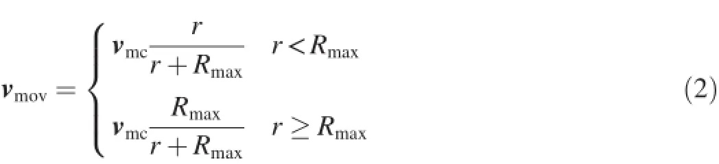
where vmcis the moving velocity vector of the cyclone center, r is the distance from the cyclone center,and Rmaxis the radius of maximum wind.
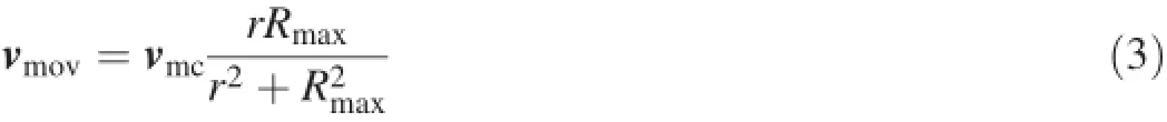
Later,Jelesnianski(1966)provided a modified formula to calculate vmov:
Ueno(1981)used an exponential function to calculate vmov:
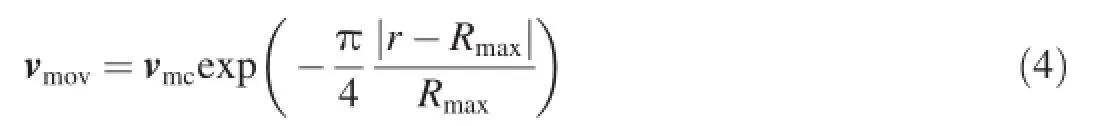
Jakobsen and Madsen(2004)used a similar exponential function to calculate vmov:

where RGis the length scale of the moving component and is about 500 km.
Eq.(5)was used to calculate the wind vector induced by the moving component in this study.The value of RGwas set to 500 km.
The rotating component is considered to be more significant to the total wind velocity than the moving component. Three different types of models,proposed by Jelesnianski (1965),Holland(1980),and Knaff et al.(2007),respectively,are commonly used to calculate the wind velocity induced by the rotating storm component.The details are given below.
Jelesnianski(1965)proposed a parametric rotating storm model,which was later modified by Jelesnianski(1966).The modified model is as follows:
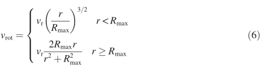
where vrotis the magnitude of vrot,and vris the maximum wind speed.
Holland(1980)proposed a synthetic asymmetric model:
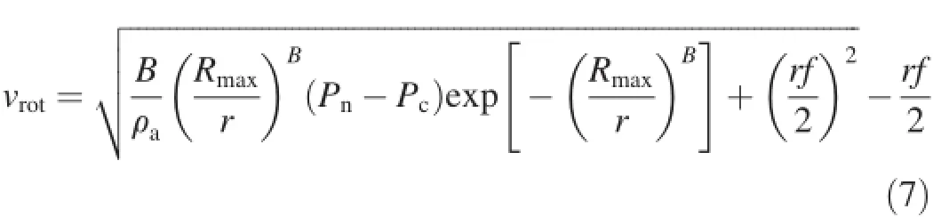
where Pnis the ambient undisturbed synoptic background surface pressure,Pcis the central surface pressure of the storm,ρa(bǔ)is the density of air,f is the Coriolis force,and B is the hurricane shape parameter,which controls the eye diameter and steepness of the tangential velocity gradient.The Holland(1980)model was further improved by Mattocks and Forbes(2008),who proposed a more detailed equation to calculate the parameter B:
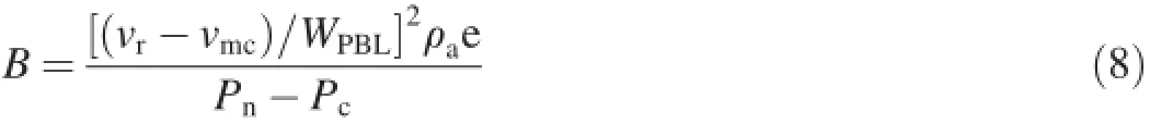
where vmcis the magnitude of vmc,and WPBLis a wind reduction factor,which is defined at the gradient wind flow level above the influence of the planetary boundary layer (Powell et al.,2003).
More recently,Knaff et al.(2007)used a modified Rankine vortex model to calculate vrot.The numerical equation is as follows:
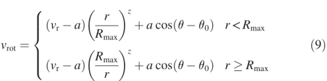
where a is the magnitude of wavenumber-1 asymmetry,z is the size parameter,θ0is the degree of counterclockwise rotation of vrfrom the direction 90°to the right of the storm motion vector, and θ is the azimuth to the tropical cyclone center.
After determining the magnitude of wind velocity induced by the rotating component,the x-and y-components of vrotcan be calculated as follows:
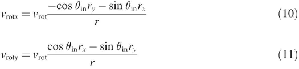
where vrotxand vrotyare the x-and y-components of vrot, respectively;rxand ryare the x-and y-components of the distance from the tropical cyclone center;and θinis the inflow angle, which can be calculated according to Queensland Government's Ocean Hazards Assessment(Queensland Government,2001).
2.2.Radius of maximum wind
The radius of maximum wind is the distance between the center of a cyclone and its band of strongest winds.It is a key factor that controls the eye diameter of the tropical cyclone and has a significant influence on the calculated wind speeds.
Graham and Nunn(1959)used an empirical equation to calculate the maximum wind radius Rmax:
where φ is the latitude of the tropical cyclone center.
Based on the measured data,Knaff et al.(2007)provided another empirical equation:

where m0,m1,and m2are empirical parameters whose values depend on the location of the tropical cyclones,e.g.,Western Pacific,Eastern Pacific,or Western Atlantic.They were set to 38.0,-0.1167,and-0.004,respectively,in this study.More details on the determination of these parameters can be found in Knaff et al.(2007).
In addition to the empirical formulas,the radius of maximum wind can also be solved according to the radii of several characteristic wind speeds(e.g.,the radii of 34-,50-, and 64-knot wind speeds).After the occurrence of a tropical cyclone,the radii of those characteristic wind speeds can be obtained based on the measured wind data.Xie et al.(2006) proposed a brute-force marching method to calculate the value of the radius of maximum wind.This method can ensure that different radii of characteristic wind speeds calculated with the cyclone wind model are the same as the ones calculated based on the measured wind data.More details about this method can be found in Xie et al.(2006).
2.3.CCMP reanalysis data
In this study,CCMP wind data with a spatial resolution of 0.25°(latitude)×0.25°(longitude)were employed as the reanalysis data to calculate the wind field of tropical cyclones. The CCMP wind data were derived through cross-calibration and assimilation of ocean surface wind data from the Special Sensor Microwave Imager(SSM/I),TRMM Microwave Imager(TMI),Advanced Microwave Scanning Radiometer-Earth Observing System(AMSR-E),SeaWinds on QuikSCAT,and SeaWinds on ADEOS-II(PODAAC/JPL/NASA, 2010).The ECMWF reanalysis(ERA-40)data were used as the starting estimate of the wind field(or background)fromJuly 1987 to December 1998 and the ECMWF Operational Analysis data were used from January 1999 onward.
3.Selected tropical cyclones
The study area is located along the coast of Fujian Province, China,on the west side of the Taiwan Strait,as shown in Fig.1. The area is frequently affected by tropical cyclones.The wind speeds were measured at one observation station,at 25°10′36′N and 119°21′54′E.Two typical tropical cyclones,i.e.,Fanapi and Meranti,which occurred in 2010,were selected.Fanapi was a typical super typhoon with relatively large values of vr(the maximum vris 52 m/s).It became a tropical depression on September 15,2010 and strengthened into a super typhoon on September 18,2010.Meranti was a typical typhoon with relatively small values of vr(the maximum vris 35 m/s).It became a tropical depression on September 8,2010 and strengthened into a typhoon on September 10,2010.The tracks of these two tropical cyclones are shown in Fig.1.
4.Performance comparisons of existing methods
The performance of the existing parametric tropical cyclone models and the performance of the methods for the calculation of the radius of maximum wind were compared via the reproduction of the measured wind speeds at the observation station.
4.1.Different tropical cyclone models
The time series of hindcasted wind speed obtained from different tropical cyclone models were compared first.The wind field of the moving component was calculated with Eq.(5)and the wind field of the rotating component was calculated with Eqs.(6),(7)and(9),from the Jelesnianski(1966)model, Holland(1980)model,and Knaff et al.(2007)model,respectively.The wind speeds calculated with different models and the measured data at the observation station for Fanapi and Meranti are plotted in Fig.2(a)and Fig.2(b),respectively.The root mean square error(RMSE)values of wind speed for the Holland(1980)model,Knaff et al.(2007)model,and Jelesnianski(1966)model in Fig.2(a)are 4.402,3.607,and 4.111 m/s,respectively(calculated from 00:00 on September 18,2010 to 23:00 on September 20,2010).The RMSE values of wind speed for the Holland(1980),Knaff et al.(2007),and Jelesnianski(1966)models in Fig.2(b)are 6.684,6.106,and 7.120 m/s,respectively(calculated from 00:00 on September 9, 2010 to 23:00 on September 10,2010).
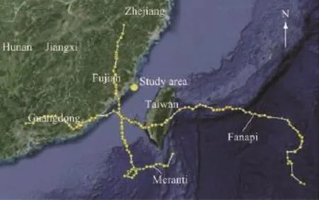
Fig.1.Cyclone center tracks of Fanapi and Meranti.
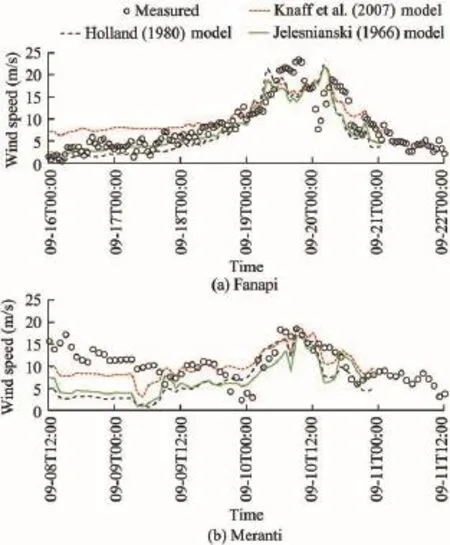
Fig.2.Time series of hindcasted wind speed obtained from different tropical cyclone models and measured data for two tropical cyclones.
As can be seen in Fig.2,when the tropical cyclone center is far from the observation station,the wind speed obtained from the Knaff et al.(2007)model tends to be higher than that obtained from the Holland(1980)or Jelesnianski(1966)model, particularly at one day before the peak wind speeds.However, the difference in the maximum wind speed between different models is quite small(the largest difference is only 1.67 m/s), indicating that different tropical cyclone models may show similar performance in the hindcasting of maximum wind speed.
4.2.Different methods for calculation of radius of maximum wind
In general there are two different methods for calculation of the radius of maximum wind.One is based on the equation of Knaff et al.(2007),and the other is based on the brute-force marching method proposed by Xie et al.(2006).In order to examine the differences between the two methods,Eq.(5)and Eq.(7)are used to calculate the moving and rotating components,respectively,but the radius of maximum wind is calculated with the Knaff et al.(2007)method and the Xie et al. (2006)method,respectively.Fig.3(a)and Fig.3(b)show the calculated wind speeds at the observation station for Fanapi and Meranti,along with the measured data for comparison.The RMSE values of wind speed for the Xie et al.(2006)and Knaff et al.(2007)methods in Fig.3(a)are 6.173 and 4.402 m/s, respectively(calculated from 00:00 on September 18,2010 to23:00 on September 20,2010),and the RMSE values of wind speed for the Xie et al.(2006)and Knaff et al.(2007)methods in Fig.3(b)are 4.911 and 6.684 m/s,respectively(calculated from 00:00 on September 9,2010 to 23:00 on September 10,2010).
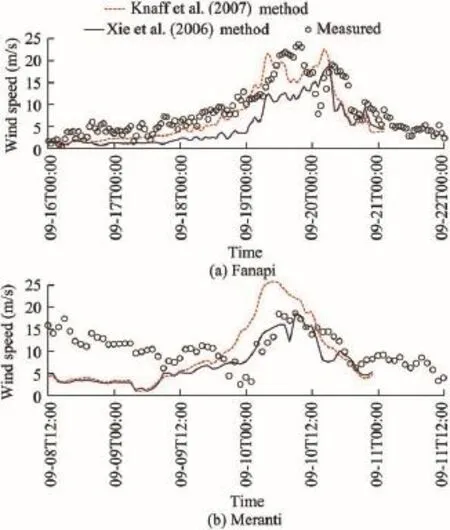
Fig.3.Comparisons of hindcasted wind speeds using different methods for calculation of radius of maximum wind and measured data for two tropical cyclones.
As can be seen in Fig.3,different methods for the calculation of the radius of maximum wind have more significant influences than different parametric cyclone models on the peak value of wind speed.Since the eye diameter of the tropical cyclone,which is determined by the radius of maximum wind, controls the scale of high-speed wind,it is understandable that the different values of the radius of maximum wind will have a significant influence on the hindcasted wind speeds.In contrast, the Knaff et al.(2007)method performs better for Fanapi with a fairly large maximum vr,and the Xie et al.(2006)method performs better for Meranti with a relatively small maximum vr. The hindcasting of other tropical cyclones in 2010 generates similar results(although not shown here),and this appears to suggest that the Knaff et al.(2007)method should be used when the maximum vris large,while the Xie et al.(2006)method should be used when the maximum vris small.Clearly,further studies are necessary to confirm these findings.
5.Improvements in hindcasting of wind fields for tropical cyclones
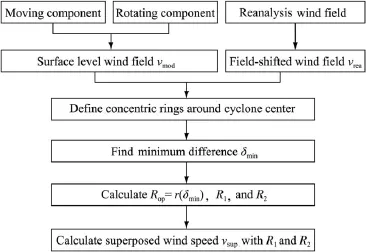
As mentioned above,the parametric tropical cyclone models generally have high accuracy in reproducing the wind field near the cyclone center.However,the errors increase with the distance from the cyclone center.Unlike the tropical cyclone models,the reanalysis data perform poorly in reproducing the wind speed around the cyclone center but better in the areas farther away from the cyclone center.In this section, two methods are proposed to improve the hindcasted results of the wind fields of tropical cyclones.The first one,the superposition method,is a combined usage of the parametric tropical cyclone model results and the reanalysis data.The methodology uses the better part of the two sets of data.The second one,the direct modification method,is a modification of reanalysis data based on the cyclone tracks.The superposition method is an optimized combination of the data from the two methods,and hence it is believed to generally perform well.
5.1.Superposition method
Due to the difference between the parametric tropical cyclone model and reanalysis data in terms of where a better performance is seen,it is reasonable to take the wind field obtained from the reanalysis data as the background and superpose the wind field generated by the parametric tropical cyclone model on the background within the area near the typhoon center.
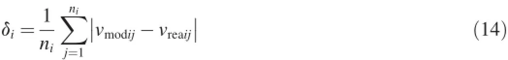
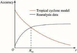
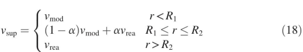
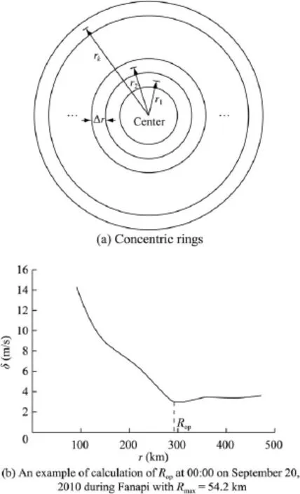
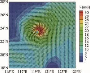
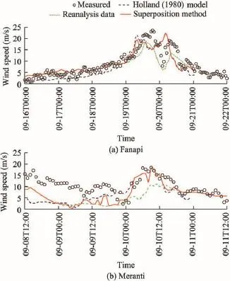
Fig.4(a)shows an example of the wind field at the moment of 00:00 on September 20,2010 during the typhoon Fanapi, calculated with the Holland(1980)model,and Fig.4(b)shows the wind field at the same moment,obtained from the CCMP reanalysis data,where v is the calculated wind speed,and the length and heading of the arrow show the magnitude and direction of the wind velocity,respectively.The computational domain extends from 18°N to 28°N and from 115°E to 125°E, here and throughout the remainder of this paper.It is noted that the cyclone center point in the reanalysis data,as indicated by B in Fig.4(b),does not coincide with the one in the cyclone model,as indicated by A in Fig.4(a).Therefore,a shift of the reanalysis wind field needs to be made before superposition.In order to make the shift smooth,an ellipse is drawn,with two foci located at the cyclone centers A and B, and with the difference between the semi-major axis a and linear eccentricity c being a given shift radius Rs,i.e., a-c=Rsas indicated in Fig.5(a).In this study the value of Rswas set to be 3°empirically.The ellipse indicates the shifted area.For a given position P after the field shift,the original position P′is sought in the ellipse and the original wind vector at P′is taken to be the post-shift wind vector at P.To do this, the line AP is extended and the crossover point C of the extension line and the ellipse is found.Then,a straight line l parallel to the line AB is drawn through P.The crossover point of l and BC is the original position P′that we seek.Fig.5(a) provides a diagrammatic sketch of the field shift.Fig.5(b) shows an example of the shifted reanalysis wind field,where the red elliptic domain is the shifted area,the arrows indicate the original position of each shifted point,and the lengths of the arrows indicate the shifted distance of each point.
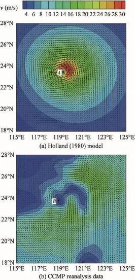
Fig.4.Comparison of wind fields of Holland(1980)model and CCMP reanalysis data at 00:00 on September 20,2010 during Fanapi with Rmax=54.2 km and vr=35 m/s.
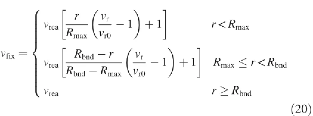
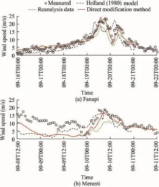
After the field shift,we need to find an optimized radius Rop,based on which the superposition is conducted.However, a sudden switch of the data would cause discontinuity of the wind field at r=Rop,and hence a smooth transition between the data from the parametric tropical cyclone model and the reanalysis data is needed.To this end,two radii of R1and R2are introduced.In the area where r As the accuracies of the tropical cyclone model and the reanalysis data change with the distance from the tropical cyclone center in a reverse way,as shown in Fig.6,we can define the optimized radius Ropas the radius at which the tropical cyclone model and the reanalysis data have the same magnitude of accuracy.In order to determine the value of Rop, a series of concentric rings are first defined around the center of the tropical cyclone,as shown in Fig.7(a)(where riis the radius of the ith concentric ring,and Δr is the width of each ring),and then the mean difference δ between the wind field obtained from the tropical cyclone model and the reanalysis data in each ring is calculated to find the minimum difference. The mean difference δicorresponding to the ith concentric ring can be calculated as Fig.5.Field shift of reanalysis wind field. where niis the number of grid points in the ith concentric ring, and vmodijand vreaijare the wind speeds at the jth grid point in the ith concentric ring obtained from the tropical cyclone model and the reanalysis data,respectively.In this study,Δr was set to be 20 km,and the calculation of δistopped when rk≤500 km and rk+1>500 km.The radius corresponding tothe minimum difference is the optimized radius Rop,which can be expressed as Fig.6.Optimized radius Ropused for superposition of tropical cyclone model data on reanalysis data. whereδminin the minimum difference,andδmin= min(δ1,δ2,…,δk). A sample of the calculation of Ropcan be found in Fig.7(b),where δ versus r is plotted,and the optimized radius Ropcan be found with the minimum difference δmin.Once Ropis known,R1and R2can be calculated with Eqs.(16)and(17) to meet the condition that R1 where Rtis the width of transition zone,and β is an empirical parameter.In this study Rtwas set to 1.2Rmax,and β was set to 0.3.With the values of R1and R2,the superposed wind field vsupcan be calculated as follows: Fig.7.Calculation of optimized radius Rop. Fig.8.Schematic diagram of superposition of tropical cyclone model data on reanalysis data. and where a is a transitional function,and vmodand vreaare the wind speeds obtained from the tropical cyclone model and the reanalysis data,respectively.A schematic diagram of the superposition method is shown in Fig.8.A sample of the wind field after superposition is plotted in Fig.9,where the length and heading of the arrow show the magnitude and direction of the wind velocity,respectively.As shown in Fig.9,a smooth transition from the wind field of the tropical cyclone model to that obtained from the reanalysis data can be clearly seen. After the superposition,the modified wind fields of the tropical cyclones Fanapi and Meranti can be obtained.It can be seen from Fig.10 that the wind speed obtained from the superposition method shows a better agreement with the measurements than those from the tropical cyclone model and the reanalysis data.The RMSE values of the hindcasted results from the Holland(1980)model,the reanalysis data, and the superposition method in Fig.10(a)are 4.402,3.728, and 3.981 m/s,respectively(calculated from 00:00 on September 18 to 23:00 on September 20,2010).The RMSEvalues of the hindcasted results from the Holland(1980) model,the reanalysis data,and the superposition method in Fig.10(b)are 6.684,6.601,and 5.334 m/s,respectively (calculated from 00:00 on September 9 to 23:00 on September 10,2010).Although the general improvement of RMSE values for Fanapi is not significant,we can see an obvious improvement in the hindcasting of peak wind speed, as shown in Fig.10(a). Fig.9.A sample of superposed tropical cyclone wind field at 00:00 on September 20,2010 during Fanapi with Rmax=54.2 km, Rop=291.4 km,and vr=35 m/s. Fig.10.Wind speeds improved by superposition of tropical cyclone model data on reanalysis data for two tropical cyclones. 5.2.Direct modification method Although the superposition method exhibits considerable improvement of the hindcasting of peak wind speed during a tropical cyclone,there sometimes exists a time difference between the hindcasted peak wind speed and the measured one,as indicated in Fig.10(a),which can be attributed to calculation error in the parametric tropical cyclone model itself.Meanwhile,the reanalysis wind data generally underestimate the large wind speeds of the tropical cyclones,but in many cases they perform better in the hindcasting of the occurrence time of peak wind speed.Based on this understanding,a direct modification of the reanalysis data is tentatively proposed;it can be numerically expressed as where vfixis the modified wind speed,vr0is the maximum wind speed in the cyclone wind field obtained from the reanalysis data,and Rbndis the radius of the modified scale, which was equal to 6Rmaxin this study. Using this method,the CCMP reanalysis data from the two tropical cyclones are modified.As shown in Fig.11,the direct modification method shows a considerable improvement, particularly at the peak of wind speed.For Fanapi,the direct modification method performs even better than the superposition method.The RMSE values of wind speed obtained from the Holland(1980)model,the reanalysis data,and the direct modification method in Fig.11(a)are 4.402,3.728,and 1.989 m/s, respectively(calculated from 00:00 on September 18 to 23:00 on September 20,2010).The RMSE values of wind speed obtained from the Holland(1980)model,the reanalysis data,and the direct modification method in Fig.11(b)are 6.684,6.601,and 5.536 m/s,respectively(calculated from 00:00 on September 9 to 23:00 on September 10,2010).A comparison of RMSE values also shows that the direct modification method performs better than the tropical cyclone model and the reanalysis data. It should be mentioned that if the reanalysis data are not able to capture the tropical cyclone,which is often the case for small typhoons,the improvement by the direct modification method will be limited.Therefore,before using the direct modification method,we should ensure that the tropical cyclone is captured by the reanalysis data. Fig.11.Wind speeds improved by direct modification of reanalysis data for two tropical cyclones. In this paper,through the hindcasting of wind fields of two typical tropical cyclones,the performance of different tropical cyclone models and methods for calculation of the radius ofmaximum wind are examined.Two different modification methods,the superposition method and the direct modification method,are proposed to improve the hindcasting of tropical cyclone wind fields.The following conclusions can be drawn: (1)The influence of different tropical cyclone models on the hindcasted maximum wind speed is relatively small. However,the radius of maximum wind has a more significant influence on the hindcasted results,particularly at the peak of wind speed. (2)The results in this study suggest that the Knaff et al. (2007)model performs better when the maximum vris large,and the brute-force marching method(Xie et al.,2006) performs better when the maximum vris small.However,this finding is empirical and based on limited case studies.Further studies are needed to verify it. (3)With the smooth shift of the reanalysis data,the superposition of the tropical cyclone model data on the reanalysis data shows a considerable improvement in the hindcasting of the time series of wind speed,while the direct modification of the reanalysis data can effectively improve the hindcasted large winds in comparison with the CCMP reanalysis data. (4)As the superposition method is a combination of two data sources,i.e.,the parametric tropical cyclone model and the CCMP reanalysis data,both of which are already widely used, the superposition method looks more reliable.The direct modification method may perform better if the CCMP reanalysis data can accurately capture the typhoon processes,like the two typhoons shown in this study.It should be mentioned that in some cases the reanalysis data may not be able to capture the tropical cyclone accurately,especially for some small tropical cyclones.Caution is needed when using the direct modification method in such cases. References Brenner,S.,Gertman,I.,Murashkovsky,A.,2007.Preoperational ocean forecasting in the southeastern Mediterranean Sea:Implementation and evaluation of the models and selection of the atmospheric forcing.J.Mar. Syst.65(1-4),268-287.http://dx.doi.org/10.1016/j.jmarsys.2005.11.018. Cavaleri,L.,Sclavo,M.,2006.The calibration of wind and wave model data in the Mediterranean Sea.Coast.Eng.53(7),613-627.http://dx.doi.org/ 10.1016/j.coastaleng.2005.12.006. DeMaria,M.,Knaff,J.A.,Knabb,R.,Lauer,C.,Sampson,C.R., DeMaria,R.T.,2009.A new method for estimating tropical cyclone wind speed probabilities.Weather Forecast.24(6),1573-1591.http:// dx.doi.org/10.1175/2009WAF2222286.1. Dube,S.K.,Sinha,P.C.,Roy,G.D.,1985.The numerical simulation of storm surges along the Bangladesh coast.Dyn.Atmos.Oceans 9(2),121-133. http://dx.doi.org/10.1016/0377-0265(85)90002-8. Gao,J.,Luettich,R.,Fleming,J.,2013.Development and Initial Evaluation of a Generalized Asymmetric Tropical Cyclone Vortex Model in ADCIRC. ADCIRC Users Group Meeting,U.S.Army Corps of Engineers, Vicksburg. Ginis,I.,Sutyrin,G.,1995.Hurricane-generated depth-averaged currents and sea surface elevation.J.Phys.Oceanogr.25(6),1218-1242.http:// dx.doi.org/10.1175/1520-0485(1995)025<1218:HGDACA>2.0.CO;2. Graham,H.E.,Nunn,D.E.,1959.Meteorological Conditions Pertinent to Standard Project Hurricane.Atlantic and Gulf Coasts of United States. Weather Bureau,U.S.Department of Commerce,Washington,D.C. Holland,G.J.,1980.An analytic model of the wind and pressure profiles in hurricanes.Mon.Weather Rev.108,1212-1218. Jakobsen,F.,Madsen,H.,2004.Comparison and further development of parametric tropical cyclone models for storm surge modelling.J.Wind Eng.Ind. Aerodyn.92(5),375-391.http://dx.doi.org/10.1016/j.jweia.2004.01.003. Jelesnianski,C.P.,1965.A numerical calculation of storm tides induced by a tropical storm impinging on a continental shelf.Mon.Weather Rev.93(6), 343-358.http://dx.doi.org/10.1175/1520-0493(1993)093<0343:ANCOS> 2.3.CO;2. Jelesnianski,C.P.,1966.Numerical computations of storm surges without bottom stress.Mon.Weather Rev.94(6),379-394.http://dx.doi.org/ 10.1175/1520-0493(1966)094<0379:NCOSSW>2.3.CO;2. Knaff,J.A.,Sampson,C.R.,DeMaria,M.,Marchok,T.P.,Gross,J.M., McAdie,C.J.,2007.Statistical tropical cyclone wind radii prediction using climatology and persistence.Weather Forecast.22(4),781-791.http:// dx.doi.org/10.1175/WAF1026.1. Lee,T.L.,2008.Back-propagation neural network for the prediction of the short-term storm surge in Taichung harbor,Taiwan.Eng.Appl.Artif. Intell.21(1),63-72.http://dx.doi.org/10.1016/j.engappai.2007.03.002. Lu¨,X.C.,Yuan,D.K.,Ma,X.D.,Tao,J.H.,2014.Wave characteristics analysis in Bohai Sea based on ECMWF wind field.Ocean Eng.91,159-171. http://dx.doi.org/10.1016/j.oceaneng.2014.09.010. Mattocks,C.,Forbes,C.,Ran,L.,2006.Design and Implementation of a Realtime Storm Surge and Flood Forecasting Capability for the State of North Carolina.University of North Carolina,Chapel Hill. Mattocks,C.,Forbes,C.,2008.A real-time,event-triggered storm surge forecasting system for the state of North Carolina.Ocean Model.25(3-4), 95-119.http://dx.doi.org/10.1016/j.ocemod.2008.06.008. Moeini,M.H.,Etemad-Shahidi,A.,Chegini,V.,2010.Wave modeling and extreme value analysis off the northern coast of the Persian Gulf.Appl. Ocean Res.32(2),209-218. Pande,M.,Ho,T.C.E.,Mikitiuk,M.,Kopp,G.A.,Surry,D.,2002.Implications of Typhoon York on the design wind speeds in Hong Kong.J.Wind Eng.Ind.Aerod.90(12-15),1569-1583.http://dx.doi.org/10.1016/ S0167-6105(02)00271-4. Physical Oceanography Distributed Active Archive Center(PODAAC)/Jet Propulsion Laboratory(JPL)/National Aeronautics and Space Administration(NASA),2010.Cross-Calibrated Multi-Platform Ocean Surface Wind Velocity,1987-ongoing.Research Data Archive at the National Center for Atmospheric Research,Computational and Information Systems Laboratory.http://rda.ucar.edu/datasets/ds744.9/[Retrieved Sep.10,2008]. Powell,M.D.,Vickery,P.J.,Reinhold,T.A.,2003.Reduced drag coefficient for high wind speeds in tropical cyclones.Nature 422,279-283.http:// dx.doi.org/10.1038/nature01481. Queensland Government,2001.Queensland Climate Change and Community Vulnerability to Tropical Cyclones:Ocean Hazards Assessment-Stage 1. Department of Natural Resources and Mines,Brisbane. Russell,L.R.,1968.Probability Distribution for Texas Gulf Coast Hurricane Effects of Engineering Interest.Ph.D.Dissertation.Stanford University, Stanford. Sampson,C.R.,Wittmann,P.A.,Serra,E.A.,Tolman,H.L.,Schauer,J., Marchok,T.,2013.Evaluation of wave forecasts consistent with tropical cyclone warning center wind forecasts.Weather Forecast.28(1),287-294. http://dx.doi.org/10.1175/WAF-D-12-00060.1. Signell,R.P.,Carniel,S.,Cavaleri,L.,Chiggiato,J.,Doyle,J.D.,Pullen,J., Sclavo,M.,2005.Assessment of wind quality for oceanographic modelling in semi-enclosed basins.J.Mar.Syst.53(1-4),217-233.http:// dx.doi.org/10.1016/j.jmarsys.2004.03.006. Ueno,T.,1981.Numerical computations of the storm surges in Tosa Bay.J. Oceanogr.Soc.Jpn.37,61-73. Wu,C.R.,Chiang,T.L.,2007.Mesoscale eddies in the northern South China Sea.Deep Sea Res.Part II Top.Stud.Oceanogr.54(14-15),1575-1588. http://dx.doi.org/10.1016/j.dsr2.2007.05.008. Xie,L.,Bao,S.W.,Pietrafesa,L.J.,Foley,K.,Fuentes,M.,2006.A real-time hurricane surface wind forecasting model:Formulation and verification. Mon.Weather Rev.134(5),1355-1370.http://dx.doi.org/10.1175/ MWR3126.1. 16 August 2015;accepted 10 December 2015 This work was supported by the National Natural Science Foundation of China(Grants No.51309092 and 51379072),the Special Fund for Public Welfare Industry of the Ministry of Water Resources of China(Grant No. 201201045),the Natural Science Fund for Colleges and Universities in Jiangsu Province(Grant No.BK20130833),and the Fundamental Research Funds for the Central Universities(Grants No.2015B16014 and 2013B03414). *Corresponding author. E-mail address:ypchen@hhu.edu.cn(Yong-ping Chen). Peer review under responsibility of Hohai University. http://dx.doi.org/10.1016/j.wse.2016.02.002 1674-2370/?2016 Hohai University.Production and hosting by Elsevier B.V.This is an open access article under the CC BY-NC-ND license(http://creativecommons.org/licenses/by-nc-nd/4.0/).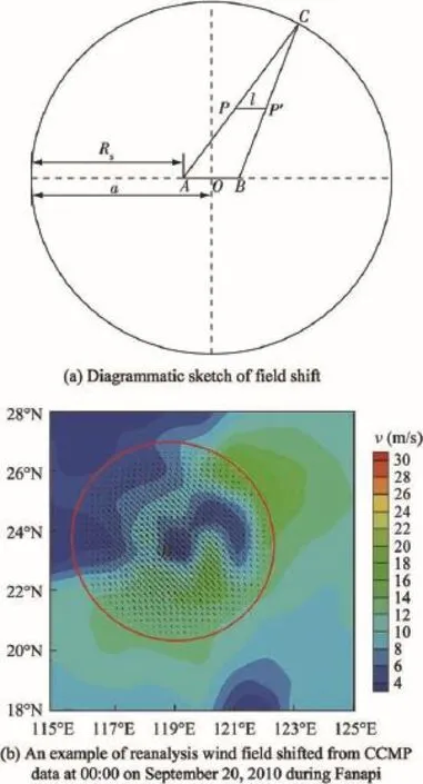


6.Conclusions
 Water Science and Engineering2016年1期