
Underestimation of Oceanic Warm Cloud Occurrences by the Cloud Profiling Radar Aboard CloudSat
2015-01-05 02:01:53LIUDongyang劉東陽LIUQi劉奇andZHOULingli周伶俐
LIU Dongyang (劉東陽),LIU Qi(劉奇),and ZHOU Lingli(周伶俐)
School of Earth and Space Sciences,University of Science and Technology of China,Hefei 230026
Underestimation of Oceanic Warm Cloud Occurrences by the Cloud Profiling Radar Aboard CloudSat
LIU Dongyang (劉東陽),LIU Qi?(劉奇),and ZHOU Lingli(周伶俐)
School of Earth and Space Sciences,University of Science and Technology of China,Hefei 230026
The Cloud Profiling Radar(CPR)onboard CloudSat is an active sensor specifically dedicated to cloud detection.Compared to passive remote sensors,CPR plays a unique role in investigating the occurrence of multi-layer clouds and depicting the internal vertical structure of clouds.However,owing to contamination from ground clutter,CPR reflectivity signals are invalid in the lowest 1 km above the surface,leading to numerous missed detections of warm clouds.In this study,by using 1-yr CPR and MODIS(Moderate Resolution Imaging Spectroradiometer)synchronous data,those CPR-missed oceanic warm clouds that are identified as cloudy by MODIS are examined.It is demonstrated that CPR severely underestimates the occurrence of oceanic warm clouds,with a global-average miss rate of about 0.43.Over the tropical and subtropical oceans,the CPR-missed clouds tend to occur in regions with relatively low sea surface temperature.CPR misses almost all warm clouds with cloud tops lower than 1 km,and the miss rate reduces with increasing cloud top.As for clouds with cloud tops higher than 2 km,the negative bias of CPR-captured warm cloud occurrence falls below 3%.The cloud top height of CPR-missed warm clouds ranges from 0.6 to 1.2 km,and these clouds mostly have evidently small optical depths and droplet effective radii.The vertically integrated cloud liquid water content of CPR-missed warm clouds is smaller than 50 g m?2.It is also revealed that CPR misses some warm clouds that have small optical depths or small droplet sizes,besides those limited in the boundary layer below about 1 km due to ground clutter.
oceanic warm cloud,Cloud Profiling Radar,MODIS,cloud occurrence underestimation
1.Introduction
Clouds play a significant role in the energy balance of the earth-atmosphere system.They affect the earth’s radiation budgets by reflecting solar shortwave radiation and absorbing/emitting longwave radiation. Cloud processes also promote vertical exchanges of water between the surface and atmosphere and thus drive the global water cycle.Since clouds develop in atmospheric flow fields and react to those fields through heating and cooling effects by radiation and phase transformation,complex cloud feedbacks have been considered as a major source of uncertainty in climate models(Bony and Dufresne,2005).Barker et al.(1999)found that for clear-sky conditions that are independent of cloud feedbacks,the discrepancy in surface radiation flux among general circulation models(GCMs)is several W m?2,while it could reach 100 W m?2for simulations under cloudy sky conditions.Comparing 10 atmospheric GCMs with satellite measurements,Zhang et al.(2005)found that the simulated seasonal variations of low-level clouds were generally poor compared with high-levelclouds.These findings all indicated that numerical models need further improvement to accurately represent cloud physical properties and their development processes involving cloud feedbacks.
Warm clouds are defined as those clouds located below the freezing level and consist exclusively of liquid droplets.Since the conditions for warm cloud formation are more attainable compared to middle and high clouds,they tend to occur more frequently in theatmosphere,resulting in significant effects in the global radiation budget.Especially over the ocean, benefiting from the adequate water supply,cumulus,stratocumulus,and stratus clouds occur in very large numbers,and single-layer oceanic stratus clouds cover nearly a third of the area of the global ocean (Charlson et al.,1987).In particular,over the tropical and subtropical oceans,warm clouds have essential effects in the radiation budgets and feedbacks of the earth-atmosphere system,due to their remarkably high reflectivity in contrast to the sea surface (Hartmann and Short,1980).Furthermore,since warm clouds are much closer to the surface,their physical properties are more susceptible to aerosols, which play an essential role in aerosol-cloud interactions.The aerosol indirect effect,which is closely related to warm clouds,is also an important aspect of anthropogenic climate forcing.Some proposed geoengineering methods aimed at mitigating the greenhouse effect are in fact based on interactions between artificial aerosols and warm clouds,which lead to increasing cloud albedo and thus reducing shortwave radiation absorption.Besides,warm clouds and their accompanying weak precipitation processes have very important impacts on the dynamic processes in the atmospheric boundary layer.Hence,accurately describing warm clouds and their related physical and dynamic processes is very meaningful to improve the reliability of climate model projects.
Satellite remote sensing has provided an excellent opportunity to further understand warm clouds, especially oceanic warm clouds on the global scale. The Earth Observing System(EOS)satellites Aqua and CloudSat are two important members of the ATrain constellation of satellites.At present,the Moderate Resolution Imaging Spectroradiometer(MODIS) aboard Aqua and the Cloud Profiling Radar(CPR) aboard CloudSat,constitute the main data source for global clouds(Weisz et al.,2007).With abundant spectral information for the retrieval of cloud properties ranging from the visible spectrum to the infrared band,MODIS is the representation of passive remote sensing in cloud measurements.CPR is a nadirpointing radar working at the millimeter-wavelength. It thus has higher sensitivity to small cloud droplets than the commonly used centimeter-wavelength radar, which is merely sensitive to precipitation-sized hydrometeors.In addition,CPR can distinguish multilayer clouds from single-layer clouds and obtain cloud vertical structure in its available resolution.In recent years,by employing CPR observations,many studies have been carried out to investigate the vertical structure characteristics of clouds and precipitation. Luo et al.(2009)and Wang et al.(2011b)analyzed cloud amounts,vertical distribution,and their seasonal variation characteristics in the Asian monsoon region.Also focusing on the Asian monsoon region, Wang et al.(2011a)studied the distribution of low clouds and the correlation between seasonalvariations and atmospheric instability in the lower troposphere. Han et al.(2013)conducted a comprehensive study to investigate the characteristics of clouds,precipitation,and the thermodynamic structure of typhoons at different stages in the eastern Pacific Ocean by using a CloudSat tropical cyclone dataset.Yi et al.(2014) reported the seasonal occurrences of deep convective clouds and their relationship with cyclonic activity in the northern Pacific.In addition,Peng et al.(2013) and Yin et al.(2013)investigated the vertical distribution and seasonal variations of precipitating and non-precipitating clouds,single-layer and multilayer clouds,by using vertical profile data form CPR measurements.
In principle,as an active radar,CPR is superior to passive sensors for detecting cloud vertical structures.For instance,MODIS obtains cloud water content through microphysical information near the top of clouds,while CPR resolves the vertical variation of cloud water content in the whole column.Especially for warm clouds in the lower atmosphere,which are often covered by middle-and high-level clouds, MODIS-retrieved results have potentially large biases because of the single-layer cloud assumption in the MODIS algorithm.However,detections by CPR in the lower atmosphere are inevitably restricted by ground clutter and the signal-to-noise ratio.Thus,there is a severe obstacle for CPR to detect these very low clouds.Mace et al.(2007)found that CPR measurements in the lowest two or three range resolution volumes above the sea surface are contaminated byground clutter,and this disturbance could extend to approximately 1 km.It was estimated that approximately two thirds of warm clouds located below 1 km tend to be undetected due to strong ground clutter that overwhelms the cloud echo signals(Marchand et al.,2008).For warm clouds in the tropical eastern Pacific Ocean,Kuber et al.(2011)found that CPR only detected one third of those identified by MODIS.Furthermore,as revealed by Chan and Comiso(2011),CPR also missed some geometrically thin,low-level clouds in high latitude and polar regions,while MODIS identified these clouds explicitly and provided unambiguous cloud property retrievals, except for optically thin clouds with a cloud optical depth smaller than 0.4.In the present study,we find that situations in which CPR identifies clear sky while MODIS identifies cloudy sky are very common over the oceans in low and middle latitudes.Undoubtedly, the failure of CPR to identify clouds that are located below the ground-clutter zone could cause underestimations of the occurrences of global oceanic warm clouds in CPR datasets.Nevertheless,CPR’s underestimation of warm clouds is stillunclear on the global scale.Knowledge on the properties of these CPR-missed warm clouds is hitherto very limited,which has a direct impact on the reasonable application and correct understanding of CPR measurements.
Since CloudSat launched and began to release data in 2006,many studies of the macrophysical and microphysical properties and vertical structures of clouds based on CPR datasets have been conducted. It thus becomes increasingly important to clearly understand the accuracy,representation,and shortcomings of these datasets.The present study addresses the aforementioned problems by attempting to quantify the CPR miss rate with respect to oceanic warm clouds and clarify its impacts.The results could help in obtaining more accurate knowledge on the occurrences and properties of global oceanic warm clouds.
2.Data and methods
The data analyzed in this study consist of the CPR 2B-GeoProf(Geometric Profile)datasets, MODIS cloud detection,and retrieved cloud properties.The atmospheric vertical temperature profile data from the ECMWF are combined with the cloud top temperature(CTT)from MODIS to estimate the cloud top height(CTH).All datasets used here cover the whole year of 2008.
2.1 CPR dataset
CPR is a 94-GHz nadir-looking millimeterwavelength radar aboard CloudSat that was launched in April 2006.CloudSat has an orbit altitude of about 705 km,an orbit inclination angle of 98.2°,and a period of 98.9 min.With a high sensitivity at-30 dBZ, CPR can obtain effective echo signals from small-sized cloud droplets and achieve straightforward cloud identification.CPR acquires 125 data samples for each profile ranging from the sea surface level to 30 km, with a vertical resolution of approximately 240 m. The effective field of view of CPR is approximately an oval,with a footprint of 1.7-km along-track and 1.4-km across-track.The along-track interval between adjacent pixel centers is about 1.1 km.
The main CPR product used is the operational 2B-GeoProf,which contains a“cloud mask”assigned for each range bin.The cloud mask has a confidence coefficient between 0 and 40,with higher values corresponding to increasing confidence of cloud presence. Marked values of 30 and 40 have low false detection rates at 0.043 and 0.006,respectively,which basically assures the presence of clouds(Marchand et al.,2008).
One ofthe reasons for CPR failing to detect cloud might be because it cannot obtain effective echoes in the ground-clutter zone.The averaged thickness of the near-surface blind zone of CPR is shown in Fig. 1 on a 2.5×2.5 grid(the same configuration for the following global distributions).Such a thickness is derived from all the clear-sky cases,and defined as the averaged height of the top bin that has much larger echo intensity than the clear-sky background.
Affected by multiple factors,the thickness of the CPR blind zone has notable spatial variations over the oceans that have relatively smooth geomorphology.Such a spatial distribution is largely related tothe sea surface elevation distribution(Tanelli et al., 2008).Over the global ocean,the averaged blind-zone thickness ranges from 400 to 650 m,corresponding to the detection failure of CPR in the first 1-3 bins from the sea surface.This means that the first entirely unaffected bin in the CPR vertical profile is at least the fourth bin above the sea surface,which is located at about 1 km.Thus,the instances of missed cloud detection are concentrated below 1 km in the CPR observations.In addition,considering the restriction of detection sensitivity,CPR also cannot detect some very thin clouds with rather low cloud water content. These missed-cloud cases due to limited sensitivity are known to be very common for CPR in detecting thin cirrus clouds(Marchand et al.,2008).
2.2 Collocation of MODIS and CPR measurements
MODIS is the main sensor aboard the NASA EOS Terra and Aqua satellite platforms,which acquires a global coverage every one or two days with a swath width of 2330 km.MODIS measures the upward radiances from the surface to atmosphere in 36 spectral bands,ranging from 0.4 to 14.2μm.Cloud detection by MODIS is achieved on a scale of 1 km,resulting in the cloud mask product,and for each cloudy pixel a series of cloud property retrievals were derived by using the operational cloud algorithm(Platnick et al.,2003).According to comparison between groundbased radars,airborne radars,and Cloud-Aerosol Lidar and Infrared Pathfinder Satellite Observations (CALIPSO),the accuracy of MODIS cloud detection is more than 90%over the low-latitude and midlatitude oceans(Ackerman et al.,2008;Holz et al.,2008). In this study,we regard the MODIS cloud detection results as the true value,using them as the basis for comparison with the CPR cloud detection results.
The standard pixel-level cloud products of MODIS are archived in the level-2 MODIS Collection 5 standard cloud product(MYD06?L2).The MODIS data required for the present study are only spatiotemporally matched with the CPR track.Therefore,the narrow-swath(about 10 km)MODIS/Aqua subset along the CloudSat track,officially termed as the MODIS/Aqua Clouds 1 and 5 km 5-Min L2 Wide Swath Subset along CloudSat V2(MAC06S0), is used in this study.The subset data provide various cloud parameters from MODIS,e.g.,cloud detection,cloud-top temperature(CTT),cloud optical depth,and cloud water path,which are in 1-or 5-km resolution.For each cloud parameter,the MAC06S0 dataset has either 3 pixels in the 5-km resolution or 11 pixels in the 1-km resolution.The MODIS and CPR pixels were collocated according to the minimum distance matching method.In the A-Train satellite constellation,CloudSat lags the Aqua orbit by approximately 60 s,which ensures the temporal synchronization of these two datasets.This con-figuration ensures a better retrieval validity of cloud parameters,since the parallax effect from MODIS is negligible in the middle part of the across-track scan (Chan and Comiso,2011).Meanwhile,the retrieval of warm cloud properties based on MODIS multi-spectral data carries much less uncertainty than ice and mixedphase clouds.Hence,CPR and MODIS provide the cloud detection and cloud parameters,respectively,for the same pixel,and such a combined dataset forms the basis for this study.

Fig.1.Averaged thickness of the CPR blind zone caused by ground clutter over the global ocean on a 2.5°×2.5°grid.
2.3 ECMWF dataset
The ERA-Interim reanalysis,produced by the ECMWF,is a global atmospheric reanalysis dataset from 1979,continuously updated in real time.In this study,we use the globalsea surface temperature(SST) dataset and the atmospheric temperature profile from the surface to 500 hPa at a spatialresolution of0.75°× 0.75°.It was combined with the CTTs from MODIS to calculate the cloud-top heights(CTHs).Considering the rough horizontal resolution of this dataset,they are collocated to every pixel of the combined satellite data.
2.4 Isolated warm clouds
In most analyses of satellite cloud data,the identification ofwarm cloud is simply based on CTT tested at the pixel level.All cloud pixels with CTT greater than 273 K are classified as warm cloud samples.However,many investigations have demonstrated that, over the globalocean and especially the tropicalocean, it is a widespread feature that warm cloud pixels are connected to cold ones.These warm cloud pixels are distinct from true warm clouds,considering their different thermal and dynamic conditions.The abovementioned cloud systems that contain both warm and cold cloud pixels are mostly at the transition stage in the development of deep cloud systems,which have completely different evolution processes compared with isolated warm clouds(Schumacher and Houze,2003;Liu and Zipser,2009).Thus,to a certain extent,analyses of oceanic warm clouds can become contaminated and unrepresentative if all pixels with CTTs greater than 273 K are simply classified into warm clouds.In order to avoid the above problems, we define isolated warm clouds in this study,which are spatially continuous and compose exclusively of warm cloud pixels.Unlike the general definition at the pixel level,the definition of warm clouds here is at the object level.Correspondingly,a single object of warm cloud consists of one or more spatially continuous warm cloud pixels.
Hence,the isolated warm clouds over the ocean were identified and samples of warm clouds created. Considering that CPR only forms one-dimensional data in the horizontal plane,the continuity filter of warm cloud pixels is solely based on the single dimension.
For each pixel in the isolated warm cloud determined by MODIS,it is defined as a CPR-captured cloud if CPR detects the cloud and identifies the CTH as below 4.5 km.Conversely,if CPR identifies the MODIS cloud-pixel(MODIS cloud fraction greater than 0.9)as clear sky,such a pixel is defined as CPR-missed cloud.It should be pointed out that the above classification rules out situations of multilayer clouds, because the retrieval of cloud properties from MODIS is very likely unrepresentative in this case.Hence, those cases in which CPR detects the presence of midor high-level cloud but misses the warm cloud in the lower layer are not investigated in this study.
2.5 Calculation of CTH
For CPR-captured clouds,the CTH is explicitly defined as the height of the top-down first bin that has a CPR cloud mask greater than or equal to 30.As for CPR-missed clouds,the MODIS CTT retrievals were used to estimate the CTH as follows:
With a relatively accurate CTT,the determination of the CTH depends mainly on the local vertical temperature structure,although it is very difficult to accurately describe the thermal structure in the lower troposphere,particularly within the atmospheric boundary layer.Therefore,a common method is to combine the CTT,near-surface air temperature and proper lapse rate profile to calculate the CTH(e.g. Sun-Mack et al.,2008;Zuidema et al.,2009;Minnis et al.,2011).Relying on the global boundary layer temperature lapse rate from the Clouds and Earth’s Radiant Energy System(CERES)cloud property re-trievalsystem(CCPRS),Sun-Mack et al.(2014)compared the CTHs derived from the above methods and CALIPSO direct measurements.They found that, over the ocean,the differences in CTH between those derived from the CCPRS-2(CCPRS-4)lapse rate profiles and those derived from CALIPSO were within 0.2(0.1)km,with a standard deviation near 0.6 km. In this study,we also combine the lapse rate from CCPRS,CTT from MODIS,and the atmospheric temperature at 1000 hPa from ERA-Interim,to calculate the CTH.It should be noted that there are still certain deviations in the calculation of CTH,as in the following aspects:(1)The CTT itself may deviate considerably,caused by the presence of an inversion layer near the top of the atmospheric boundary layer and the transmission of the infrared radiation emitted from the sea surface through the optically thin clouds. (2)The default hypothesis in the method is the equality between CTT and ambient air temperature around the top of the cloud.However,in practice,they are generally different,which might cause a deviation of about 0.15 km(Zuidema et al.,2009).(3)The lapse rate from CCPRS only reflects the variable relationship of the atmospheric temperature profile along with latitude,which is still apart from the real lapse rate in local regions.However,these are all random errors and would not form consistent system deviations in the estimation of CTH.
3.Results
3.1 Occurrence frequency characteristics
Figure 2 shows the global distribution of the occurrence frequency of CPR-missed(Fig.2a)and CPR-captured clouds(Fig.2b)over the whole year of 2008.The oceanic warm clouds are mainly located over subtropical oceans,in 20°-30°north and south of the equator.Especially over the extensive Pacific Ocean,there are clearly more warm clouds located in Northeast and Southeast Pacific(Jensen et al.,2008;Zhang et al.,2010).On the contrary,few occur in the North Pacific storm track and the deep convective regions of the equator,western Pacific,and the intertropical convergence zone.Hence,the basic spatial distribution pattern of global warm clouds is approximately opposite to the high incidence areas of deep convective clouds and precipitation,which is also reflected in the completely different background flow fields for these two typical clouds over the ocean(Liu et al.,2010a).
As for the difference between Figs.2a and 2b, CPR-missed clouds are primarily present over relatively colder waters in the eastern ocean,usually adjacent to the west of continents.There are more CPR-captured clouds occurring in the middle of the tropical and subtropical ocean.Although high incidence areas of CPR-missed and CPR-captured clouds are very close,the latter is larger and has higher occurrence frequency.In high incidence areas,the occurrence frequency of CPR-captured clouds can reach more than 5%,while CPR-missed clouds are concentrated within 1.6%-3.0%.In the central ocean,CPR-captured clouds have relatively higher occurrence frequency(>1.2%),where few CPR-missed clouds occur(<0.4%).In addition,both CPR-missed and CPR-captured clouds rarely occur over high-latitude oceans above 50°N and 50°S.At the same latitude, compared to CPR-captured clouds,many more CPR-missed clouds are located closer to the continents. Such a distribution pattern shows that CPR tends to miss warm clouds over waters with relatively lower SST.Considering the blind zone of CPR at approximately 1 km above the sea surface,there would be plenty of warm clouds restricted under the atmospheric boundary layer over cold waters,which are unable to break through the boundary layer and reach the effective detection height of CPR.This is the main reason for the high levelof missed detection of oceanic warm clouds.
In fact,the abovementioned analysis reveals the global distribution of the absolute quantity of CPR-missed clouds.Since the CPR-captured clouds are dominant in most areas and distributions of CPR-captured and CPR-missed clouds overlap in their high incidence areas,defining a miss rate will be beneficial in terms of clarifying the characteristics of CPR missed detections of global oceanic warm clouds.The miss rate in this study is defined as the proportion ofCPR-missed cloud pixels among totalwarm cloud pixels in each region.To some extent,the value of the miss rate represents the proportion of warm clouds restricted under the atmospheric boundary layer,which directly reflects the deviations in CPR detections of warm clouds in various regions.The statistical results show that the average miss rate of CPR for global oceanic warm clouds is approximately 0.43 in the whole of 2008,meaning nearly half of these clouds were missed by CPR over the ocean.Thus,an underestimation of nearly 50%will result in when directly using CPR measurements to estimate the global oceanic warm cloud amount.Meanwhile,it also reflects that, over the global ocean,those warm clouds whose locations are restricted to under the atmospheric boundary layer account for an evidently large proportion of the total warm cloud amount,which should not be neglected in statistical analyses of warm cloud amounts and their microphysical properties.
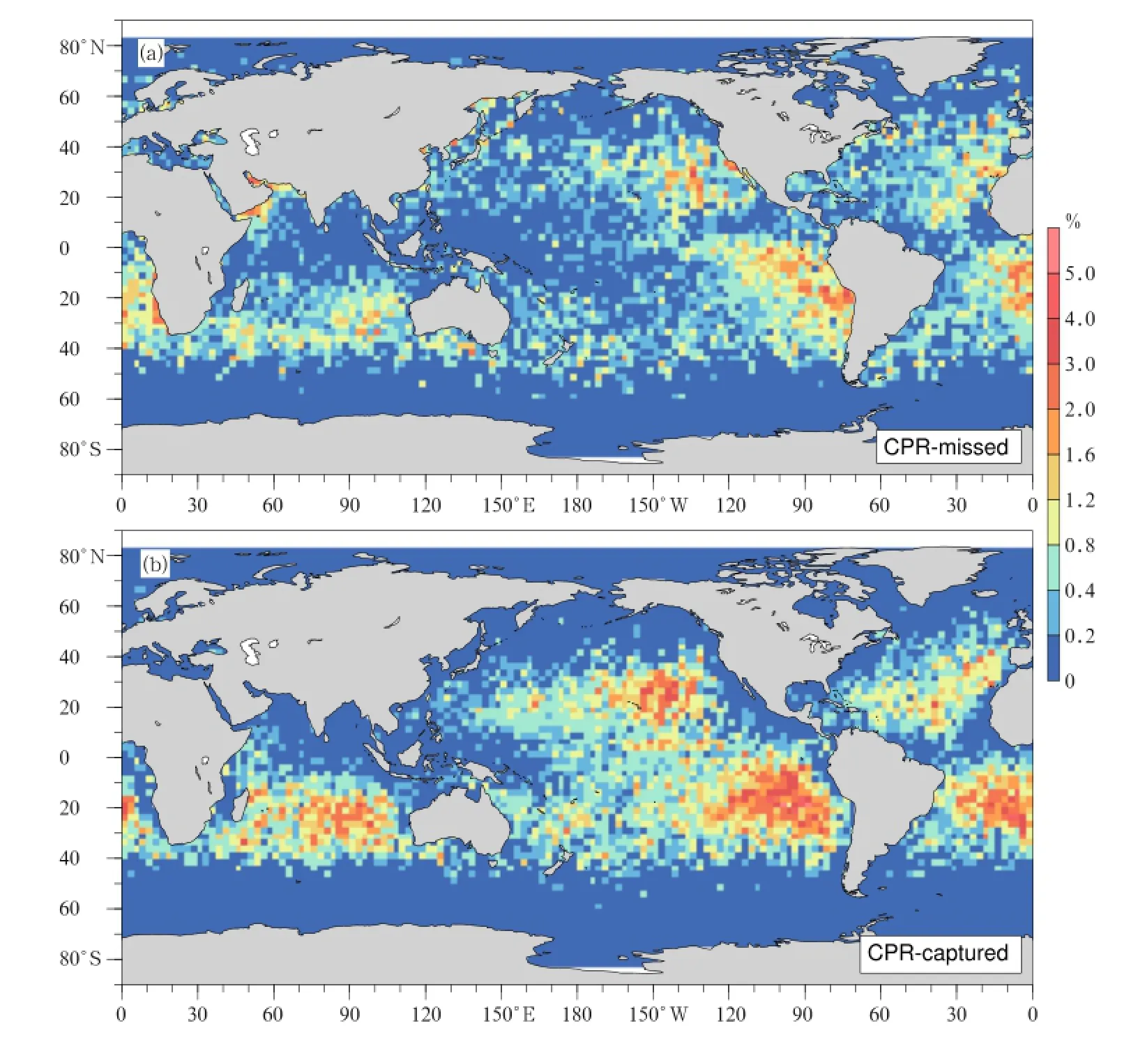
Fig.2.Occurrence frequency of(a)CPR-missed and(b)CPR-captured oceanic warm clouds in 2008.
The distribution of the miss rate over the global ocean is shown in Fig.3,but only the grids with more than 50 warm cloud pixels are displayed,considering the representation of the miss rate calculation.It can be seen that,relative to the lower value of the miss rate within 0.1-0.2 in the central oceans,the miss rate of inshore areas is generally higher,with many reaching more than 0.7.Among these regions,high values along the west coasts of the American and African continents are probably caused by the suppression of convective activities due to the locally lower SST.Low clouds arise frequently and most are unable to penetrate the top of the atmospheric boundary layer.On the contrary,although there are also high miss rates along other coasts,such as the northern Indian Ocean near the Arabian Peninsula and the east coasts of the East Asian continent and North American continent, the absolute quantity of warm clouds is quite small. The indication is that the dynamical conditions inthese regions are not appropriate for warm-cloud formation.Once formed as warm clouds under suitable conditions,they are mostly boundary layer clouds. This is probably due to the large-scale condensation processes generated in these regions by the interaction of distinct sea and land air masses.
The western Pacific warm pool is the region with the lowest miss rate in the low and middle latitudes. Although warm clouds are not frequent there,they can mostly break through the boundary layer over 1 km, and are identified as CPR-captured clouds.The miss rate near 40°N and 40°S is consistently high,which indicates boundary-layer clouds account for a large portion in these regions.Since the freezing level is lower in high latitudes,there is relatively narrower space for warm-cloud formation.In addition,warm cloud amounts decrease obviously compared with those in the low latitude oceans.All these factors lead to the consistently high value of the miss rate at high latitudes.Figure 4 shows the zonal distribution of the miss rate with warm cloud amounts and zonal average SST,in which data in the high-latitude and polar regions above 60°have been neglected due to corresponding small sample volumes.As shown in Fig.4a, in the high incidence regions of warm clouds over the tropical and subtropicalocean,the cloud-amount contribution from the boundary layer clouds is stable at 40%,slightly higher in the Northern Hemisphere than the Southern Hemisphere,which leads to the miss rate at 0.4 in these regions.This basically determines the global average miss rate.On the whole,the distribution of the miss rate is negatively correlated with the average SST on large scales(Fig.4b).The miss rate remains steady at approximately 0.4 in the tropics.With increasing latitude,warm cloud amounts uniformly decrease,while the miss rate uniformly increases and can reach more than 0.7 up to north and south of 50°of latitude.
3.2 Altitude characteristics of CPR-missed and CPR-captured clouds
The CTH reflects the vertical instability and intensity of the vertical movement,and the corresponding cloud temperature directly determines the external longwave radiation.Thus,it is also an important factor affecting cloud radiative forcing.The active detection method of CPR can obtain the CTH and,to some extent,resolve the cloud vertical structure from top to base.Nevertheless,with regard to CPR-missed clouds,CTH was calculated by the above method(in Section 2)with MODIS CTT.With the calculated CTH,the vertical distribution characteristics of CPR-missed clouds are available,which is beneficial for understanding the reason that leads to the missed detection by CPR of these warm clouds over the ocean. Meanwhile,relevant statisticalresults are necessary to complement the investigations of cloud vertical structure characteristics with the CPR datasets.
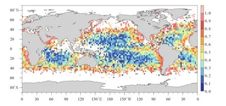
Fig.3.Global distribution of the miss rate of oceanic warm clouds(only grids with 50 or more valid pixels are shown).

Fig.4.Zonal mean distributions of the miss rate(dashed line)with(a)warm cloud amounts and(b)sea surface temperature(solid line)across the global ocean.

Fig.5.Global distributions of CTHs of(a)CPR-missed and(b)CPR-captured oceanic warm clouds.
As shown in Fig.5,few CPR-missed clouds have a CTH higher than 1.2 km,while CPR-captured cloudsare mostly higher than 1.5 km.Thus,the difference in the CTH between these two types of cloud samples is obvious,suggesting that there are great deviations in the vertical distribution of occurrence frequency of warm clouds,due to many missed detections by CPR. Most of the CPR-missed clouds are located under the atmospheric boundary layer and have CTH concentrated within 0.6-1.2 km.The distribution pattern revealed in Fig.5a approximately reflects the CTH distribution of the warm clouds below the boundary layer over the global ocean.Based on the aforementioned analysis,in high incidence regions within the Pacific and Atlantic oceans,CPR-missed clouds have relatively higher CTH,which are more likely to break through the boundary layer.On the other side,along the east coasts with a higher miss rate,CPR-missed clouds are restricted to below 0.6 km,certainly limited under the atmospheric boundary layer.Hence, the value of the CPR miss rate is directly associated with the CTH of warm clouds.
The inshore region ofthe western American continent is the most active area for forming boundary-layer clouds throughout the global ocean.Since boundary layer clouds dominate warm clouds in this region,CPR makes more missed detections and yields a higher miss rate.The CTH of CPR-missed clouds tends to decrease progressively from central oceans to western coasts.By contrast,the CTH distribution of CPR-captured clouds is more uniform(Fig.5b),and CTH slowly decreases from more than 2 km to near 1.5 km from west to east across the ocean,in accordance with the variation of the cloud types with changing SST. As revealed in previous studies,from west to east,the dominant three types of low cloud are trade cumulus,stratocumulus,and cumulus,respectively(Norris, 1998).It is worth noting that,although the warm clouds here are required to have the first effective echo from CPR under 4.5 km and a CTT greater than 273 K,warm clouds are intensively located in lower layers. Only a few of them can reach more than 2.5 km,forming a specific mode of the vertical distribution of the warm clouds(Huang et al.,2012;Gao et al.,2014).In particular,the boundary-layer clouds that CPR fails to detect constitute a major part of low clouds.These clouds feature totally different latent heating and radiative forcing compared to CPR-captured clouds.
As analyzed above,in the CTH statistics ofglobal warm clouds using the CPR data only,obvious overestimation would definitely be caused because of the severe level of missed detections of boundary-layer clouds by CPR.In order to clarify the impacts from the exclusion of CPR-missed clouds,the difference in the CTH between the CPR-captured and totalamount of warm clouds was calculated,to demonstrate the extent of the overestimation;the results are presented in Fig.6,in which only those grids with more than 50 pixels of both CPR-missed and CPR-captured clouds are displayed.The CPR-captured clouds tend to consistently overestimate the CTH of total warm clouds over the globalocean,and the biases are diverse across different regions.In the central Pacific,Atlantic,and Indian oceans,where CPR-captured clouds play a dominant role,the difference in the CTH between the CPR-captured clouds and total warm clouds is generally smaller than 0.4 km,with an overestimation of about 20%.Nearer to the continents,CPR-missed clouds become gradually more dominant and the CPR overestimation becomes even more severe,with a difference even larger than 0.8 km.Since boundary-layer clouds with very low CTH are dominant,the overestimation of the CTH can reach more than 50%.
Since the lowest height of effective detection by CPR is not constant over the global ocean,utilizing the CTH of CPR-missed clouds calculated from MODIS CTT helps to further clarify the miss rate of CPR at different heights,as shown in Table 1(pixels with CTT greater than SST were removed in the calculation).It can be seen that nearly 70%of the CPR-missed clouds are located under the atmospheric boundary layer,with a top at around 1 km,while more than 80%of the CPR-captured clouds are present within 1.0-2.5 km.As for the warm clouds located below 1 km,the miss rate is up to 0.991,implying that CPR misses nearly all the warm clouds there. However,for the warm clouds located within 1.0-1.5 km,the miss rate decreases to 0.443,and it decreases rapidly with increasing CTH.Since the ground clutter can barely reach 1.5 km,the missed warm clouds withCTH higher than 1.5 km probably result from the absence of an effective echo,as is also the case for the missed thin cirrus clouds by CPR.On the whole,the warm clouds under 1 km occupy a large proportion of global oceanic warm clouds,which are almost entirely missed by CPR,therefore leading to the average missing rate of approximately 50%on the global scale. Whereas,for warm clouds higher than 2 km,the detection results from CPR show no evident bias,with a miss rate as low as 0.024.The statistics of cloud parameters for these clouds are highly reliable.
According to the above results,the distribution of warm clouds is far from uniform over the ocean,with several remarkable regions that have very high occurrences.Although most of them are located over the tropical and subtropical ocean,their background atmospheric and oceanic circulation states are different. In order to avoid distortion of the statistical results, which could result from excessive smoothing ofthe statisticalresults from large scales,five sample areas were selected for further analysis.The locations and sample volumes for these areas are shown in Fig.7.These five chosen areas are extremely active in terms of warmcloud development,contributing more than 95%of the warm cloud amounts over the global ocean.Moreover, both CPR-missed and CPR-captured clouds account for high proportions,with a miss rate ranging between 0.28 and 0.55.

Fig.6.Global distribution of CTH differences between CPR-captured and total warm clouds.
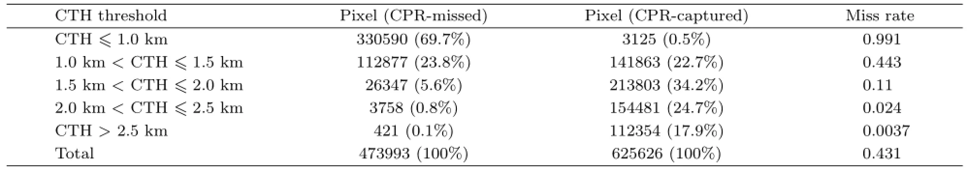
Table 1.CPR miss rate of oceanic warm clouds at different heights

Fig.7.The five selected oceanic sample areas that have sufficient warm-cloud samples.Area A:the northeastern Pacific,Area B:the southeastern Pacific,Area C:the central Indian Ocean,Area D:the north of the Atlantic,and Area E:the southern Atlantic Ocean.

Fig.8.Frequency distribution of CTH of the(a)CPR-missed,(b)CPR-captured,(c)total warm clouds,and(d)a special comparison in Area A.
In the five sample areas,the CTH features of the CPR-missed and CPR-captured clouds are analyzed at the pixel rather than grid level.The frequency distribution of CTH in the five sample areas is shown in Fig.8.As shown in Fig.8a,the CTH of CPR-missed clouds is primarily located under 1.6 km,with peaks ranging from 0.5 to 1.3 km in various regions.In the southeastern Pacific(Area B)and the central Indian Ocean in the Southern Hemisphere(Area C),CPR-missed clouds have consistently higher CTH,with a peak above 1 km,and few located below 0.5 km.In contrast,the CTH is consistently lower in the north of the Atlantic(Area D)and in the northeastern Pacific(Area A)in the Northern Hemisphere.Sincethe impacts from seasonal variations were removed in the calculation of the global average,the above deviations reflect the fact that between the Northern and Southern Hemispheres there are essentialdifferences in the development of low clouds within the atmospheric boundary layer(Huang et al.,2012).Figure 8b shows that CPR-captured clouds are truncated at approximately 0.8 km,consistent with the statistical results of the CPR blind-zone thickness(Fig.1).The effective detection echo height of CPR is approximately 0.8 km,reaching at least the fourth bin above the sea surface.As for CPR-captured clouds,which account for more than 50%in the total samples,the CTHs are primarily located within 1.1-2.5 km,with peaks at 1.5-2.0 km,which are approximately 1 km higher than those of CPR-missed clouds.The CPR-captured and CPR-missed clouds possess similar peak frequencies and integral frequencies,and their proportions in total samples are both close to 50%.The above results indicate that most warm clouds are located at 2.5 km above the sea surface,with rather few appearing at higher levels.Considering most of the five sample areas are primarily located in the tropical and subtropical ocean,it is also suggested that extremely few warm clouds can reach up to the freezing level(about 4 km).The CTH frequency distributions of the total warm clouds are presented in Fig.8c.Although the frequency profile retains a unimodal distribution after the addition of the CPR-missed clouds,the distribution pattern changes greatly.In terms of regional variation,the highest peak of about 1.8 km occurs in the central Indian Ocean,higher than the other four sample areas.As mentioned above,there is also a high occurrence frequency of warm clouds in the central Indian Ocean;the universally higher CTH and correspondingly lower CTT would jointly impose unique radiative effects in this particular region.
CPR-missed clouds have significant impacts on accurately analyzing the vertical distribution of warm clouds.For instance,in Area A(Fig.8d),total warm clouds,which represent the real situation of oceanic warm clouds,have a distribution with lower CTH and smaller peak frequency compared to CPR-captured clouds.The peak height falls below 1.5 km.Consequently,the warm clouds under 1.5 km account for nearly half of all samples,which is obviously higher than the statistical results from CPR-captured clouds alone.Therefore,although CPR has unique advantages in detecting multi-layer clouds and cloud vertical distributions,the restriction imposed by its blind zone near the surface leads to obvious statistical errors in warm cloud amounts and CTH.CPR can only detect clouds to break through the atmospheric boundary layer,which primarily consist of cumulus clouds. Meanwhile,CPR regularly misses those clouds that are trapped within the atmospheric boundary layer, which are mostly stratus and stratocumulus clouds. Hence,it is necessary to combine with other detection methods,to acquire more accurate measurements of global oceanic warm clouds.Similarly,there will be definite deviations in descriptions of the microphysical properties of warm clouds when using CPR alone to measure oceanic warm clouds.
3.3 Microphysical properties of CPR-missed clouds
Given that the CPR-missed clouds are mostly located within the atmospheric boundary layer,the microphysical properties of these special clouds cannot be obtained from CPR.Meanwhile,since MODIS is unable to specifically exclude multilayer cloud situations,using MODIS cloud products alone also cannot accurately acquire the properties of CPR-missed clouds.Nevertheless,the combination of these two datasets provides an available opportunity to further investigate CPR-missed clouds.The CPR profiles exclude the potential upper-level clouds,and MODIS retrievals for single-layer cloud provide reliable microphysical properties in the CPR blind zone.
Figure 9a shows the frequency distribution of cloud droplet radius(CDR)of CPR-missed clouds in the five sample areas.The CDR population peaks within 7-9μm and is primarily concentrated within 7-12μm,which accounts for 47.8%-56.7%.This dominance of low CDR values suggests the ma jority of CPR-missed clouds might be non-precipitating clouds.Approximately 19.7%-26.5%of CPR-missed clouds have a CDR achieving the common size of precipitating particles(about 15μm).The frequency distribution of cloud optical depth(COD)of CPR-missed clouds in the five sample areas is shown in Fig.9b.It is evident that the COD of CPR-missed clouds is primarily concentrated within 1-6 and accounts for 53.0%-67.0%.In addition,the CPR-missed clouds with a COD smaller than 1 account for approximately 5.8%-10.6%,which may contain some thin cirrus clouds that are missed by CPR and misjudged as warm clouds by MODIS.In the central Indian Ocean(Area C),CPR-missed clouds have larger CDR and smaller COD,and correspond to higher CTH,shown in Fig.8,while the opposite is true in the southern Atlantic Ocean(Area E).This indicates that CPR-missed clouds in Area C have more high/thin warm clouds,while in Area E there are more low/thick warm clouds.Dong et al. (2014)and Xi et al.(2014)investigated the microphysical properties of oceanic boundary-layer clouds in the Azores(Area D)with MODIS products and Atmospheric Radiation Measurement Program measurements.Their COD mean value was 13.1,much greater than the COD of CPR-missed clouds(4.8)derived in this study,which is probably due to the different samples employed.
It should be pointed out that there are several reasons for CPR missing oceanic warm clouds.For those located below 1 km,ground clutter effects play a dominant role and lead to the average miss rate of CPR exceeding 0.9(Table 1).For warm clouds located within 1.0-2.0 km,the average miss rate is 0.281. Since ground clutter has little impact in this layer, the missed detections by CPR might result from the smaller COD and CDR.The two-dimensional distributions of the COD and CDR of CPR-missed(Fig. 10a)and CPR-captured(Fig.10b)clouds in the five sample areas show that,for CPR-missed clouds,the groups of COD and CDR are primarily concentrated in relatively small values(1<COD<6 and 7<CDR<12μm),and the cloud amounts decrease with increasing COD and CDR.On the contrary,the groups of CPR-captured clouds have more uniform distributions.Their COD is primarily located within 3-9 and reaches up to more than 15.The CDR of these clouds is primarily located within 14-20μm,with some reaching the upper limit of the MODIS COD retrieval. Thus,compared to CPR-missed clouds,CPR-captured clouds have both larger COD and CDR.In addition, most of them are optically thicker oceanic warm clouds with larger CDR and are more likely to be associated with precipitation.It is also indicated that,for clouds with the same COD,the smaller the CDR is(CDR<12μm),the more likely the CPR fails to detect clouds.

Fig.9.Frequency distributions of(a)CDR and(b)COD of the CPR-missed clouds in the five sample areas.

Fig.10.Two-dimensional distributions of the sample amounts of the COD/CDR for(a)CPR-missed and(b)CPR-captured clouds in five sample areas,and the miss rate of(c)total warm clouds and(d)warm clouds with CTH higher than 1 km.
Figure 10c shows distributions of the miss rate in different COD/CDR combinations in the five sample areas.When CDR is smaller than 10μm,CPR shows a severe levelofmissed detection,with a continuously high miss rate of larger than 0.8.With increasing CDR,the miss rate decreases continuously.Since CPR misses almost all warm clouds located below 1 km,due to ground clutter,it is not clear whether these missed detections are in part caused by the microphysical properties of those clouds.Therefore,in order to exclude the impacts from these CPR-missed pixels,we recalculated the distribution of the miss rate after removing the CPR-missed clouds located below 1 km, as shown in Fig.10d.According to the results,when CDR is smaller than 10μm,the impacts from COD are less obvious and the miss rate remains larger than 0.8 in each CODbin.When CDRis larger than 10μm,the impacts from COD gradually emerge,with the miss rate decreasing consistently with COD.In addition, for COD larger than 12,the miss rate remains below0.3 in each CDR bin.Since the COD of oceanic warm clouds is generally small,the CDR might be one of the key factors at play in the missed detections of CPR, especially for those warm clouds with tops higher than 1 km.As for the warm clouds with large COD,those with smaller CDR(<10μm)have millimeter-wave reflectivities that are possibly too weak to be detected by CPR(Liu et al.,2010b).In addition,the statistical results of cloud water path(CWP)of CPR-missed and CPR-captured clouds in the five sample areas(Table 2)indicate that the CWP from CPR-missed clouds is 75 g m?2smaller than that from CPR-captured clouds.This means that the majority of CPR-missed clouds are non-precipitating clouds with quite low water content,while CPR-captured clouds are more likely to generate precipitation.
The statistical results in the five areas indicate that the CDR and COD of CPR-missed clouds are primarily concentrated within 6-12 and 1-6μm,respectively.The corresponding CWP is concentrated at approximately 40 g m?2.Thus,the suggestion is that the CPR-missed clouds are generally optically thin and weak non-precipitating clouds with very low CWP.In short,besides the interference ofground clutter,low COD and CDR also contribute to the failed detection of many oceanic warm clouds by CPR.
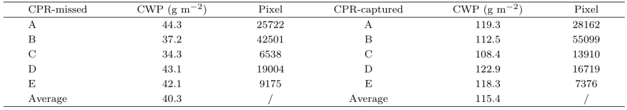
Table 2.CWP of CPR-missed and CPR-captured clouds in the five areas(A,B,C,D,and E)
4.Conclusions
As an important member of the A-Train constellation of satellites,CPR aboard CloudSat is the first space-borne millimeter-wavelength radar.Relative to the passive remote sensing of the International Satellite Cloud Climatology Project for recording global cloud amounts,the cloud detection of CPR in principle represents great progress,playing an indispensable role in investigations of cloud vertical structure globally,and corresponding atmospheric heating.However,CPR is of course not a perfect solution for detecting clouds and precipitation.Furthermore,some technical constraints also lead to some limitations in the application of the CPR datasets.The missed detection of high,thin cirrus clouds due to the sensitivity of CPR has been widely acknowledged,but the impacts on low-cloud detection from ground clutter effects are still unclear.In this study,we have investigated the underestimation of global oceanic warm clouds by CPR.The cloud amounts,CTHs and microphysical properties of CPR-missed clouds have been examined by using the synchronous data from MODIS. The main conclusions can be summarized as follows:
(1)CPR-missed warm clouds mainly arise over the relatively cold waters of the eastern ocean.The warm-cloud miss rate of CPR is negatively correlated with the zonal average SST.The miss rate in the centralocean is approximately 0.1-0.3 and increases gradually with closer proximity to the continents.The miss rate ofinshore areas exceeds 0.7,while the globalmean CPR miss rate is 0.43.
(2)For warm clouds at various altitudes,the quantities of CPR missed detections are quite different.Almost all warm clouds located below 1 km are missed by CPR,while the miss rate gradually decreases with increasing CTH.The detection results of CPR for warm clouds higher than 2 km are basically credible,with a negative bias of around 3%.
(3)The CTH of the CPR-missed clouds is primarily located within 0.6-1.2 km and nearly 70%of the CPR-missed clouds are located under 1 km.Conversely,more than 80%of the CPR-captured clouds are located within 1.0-2.5 km.By using the datasets of MODIS and CPR jointly,almost all oceanic warm clouds occur below 2.5 km.In the upper atmospherethere are barely any warm clouds.
(4)The CDR and COD of the CPR-missed clouds are generally smaller.The corresponding CWP is lower than 50 g m?2.Most of the CPR-captured clouds are thicker and have CWP larger than 100 g m?2,more likely to form precipitation.It is also found that,in the lower atmosphere,besides ground clutter effects,CPR tends to miss clouds with rather small COD and CDR.
On the whole,over the oceans,boundary-layer clouds located below 1 km should not be neglected due to their considerable contribution to the total oceanic warm cloud amount.Hence,for oceanic warm clouds,there will be severe statistical deviations in terms of cloud amounts and parameters,when relying on traditional methods that directly remove the CPR profiles within the ground clutter zone.The investigation in this study provides a reference to improve the accuracy in our understanding of quantitative results derived from CPR and,further,the advantage of combining multiple sources of satellite data has been demonstrated.Clearly,combining the information from various active and passive satellite instruments is a crucial approach to achieving advanced applications of satellite remote sensing datasets in the future.
Acknowledgments.The authors are grateful for constructive suggestions from the two anonymous reviewers.The authors would like to acknowledge the NASA CloudSat project for sharing the CPR and MODIS product data.
REFERENCES
Ackerman,S.A.,R.E.Holz,R.Frey,et al.,2008:Cloud detection with MODIS.Part II:Validation.J.Atmos.Oceanic Technol.,25,1073-1086.
Barker,H.W.,G.L.Stephens,and Q.Fu,1999:The sensitivity of domain-averaged solar fluxes to assumptions about cloud geometry.Quart.J.Roy. Meteor.Soc.,125,2127-2152.
Bony,S.,and J.-L.Dufresne,2005:Oceanic boundary layer clouds at the heart of tropical cloud feedback uncertainties in climate models.Geophys.Res. Lett.,32,L20806,doi:10.1029/2005GL023851.
Chan,M.A.,and J.C.Comiso,2011:Cloud features detected by MODIS but not by CloudSat and CALIOP.Geophys.Res.Lett.,38,L24813,doi: 10.1029/2011gl050063.
Charlson,R.J.,J.E.Lovelock,M.O.Andreae,et al., 1987:Oceanic phytoplankton,atmospheric sulphur, cloud albedo and climate.Nature,326,655-661.
Dong Xiquan,Xi Baike,A.Kennedy,et al.,2014:A 19-month record of marine aerosol-cloud-radiation properties derived from DOE ARM mobile facility deployment at the Azores.Part I:Cloud fraction and single-layered MBL cloud properties.J.Climate,27,3665-3682.
Gao Wenhua,Sui Chung-hsiung,and Hu Zhijin,2014:A study of macrophysical and microphysical properties of warm clouds over the Northern Hemisphere using CloudSat/CALIPSO data.J.Geophys.Res.,119, 3268-3280.
Han Ding,Yan Wei,Ye Jing,et al.,2013:Analyzing cloud,precipitation,and thermal structure characteristics of typhoons in eastern Pacific based on CloudSat satellite data.Chinese J.Atmos.Sci.,37,691-704.(in Chinese)
Hartmann,D.L.,and D.A.Short,1980:On the use of earth radiation budget statistics for studies of clouds and climate.J.Atmos.Sci.,37,1233-1250.
Holz,R.E.,S.A.Ackerman,F.W.Nagle,et al., 2008:Global Moderate Resolution Imaging Spectroradiometer(MODIS)cloud detection and height evaluation using CALIOP.J.Geophys.Res.,113, D00A19,doi:10.1029/2008JD009837.
Huang Yi,S.T.Siems,M.J.Manton,et al.,2012:The structure of low-altitude clouds over the southern Ocean as seen by CloudSat.J.Climate,25,2535-2546.
Jensen,M.P.,A.M.Vogelmann,W.D.Collins,et al., 2008:Investigation of regional and seasonal variations in marine boundary layer cloud properties from MODIS observations.J.Climate,21,4955-4973.
Kubar,T.L.,D.E.Waliser,and J.-L.Li,2011:Boundary layer and cloud structure controls on tropical low cloud cover using A-train satellite data and ECMWF analyses.J.Climate,24,194-215.
Liu,C.,and E.J.Zipser,2009:“Warm rain”in the tropics:Seasonal and regional distribution based on 9 years of TRMM data.J.Climate,22,doi: 10.1175/2008JCLI2641.1,767-779.
Liu Qi,Fu Yunfei,and Feng Sha,2010a:Geographical patterns of the cloud amount derived from the ISCCP and their correlation with the NCEP reanalysis datasets.Acta Meteor.Sinica,68,689-704.(in Chinese)
Liu Shuang,G.Heygster,and Zhang Suping,2010:Comparison of CloudSat cloud liquid water paths in Arctic summer using ground-based microwave radiometer.J.Ocean.Univ.China,9,333-342.
Luo Yali,Zhang Renhe,and Wang Hui,2009:Comparing occurrences and vertical structures of hydrometeors between eastern China and the Indian monsoon region using CloudSat/CALIPSO data.J.Climate,22,1052-1064.
Mace,G.G.,R.Marchand,and Q.Zhang,et al., 2007:Global hydrometeor occurrence as observed by Cloud Sat:Initial observations from summer 2006.Geophys.Res.Lett.,34,L09808,doi: 10.1029/2006GL029017.
Marchand,R.,G.G.Mace,T.Ackerman,et al.,2008: Hydrometeor detection using Cloudsat—An earthorbiting 94-GHz cloud radar.J.Atmos.Oceanic Technol.,25,519-533.
Minnis,P.,S.Sun-Mack,D.F.Young,et al.,2011: CERES Edition-2 cloud property retrievals using TRMM VIRS and Terra and Aqua MODIS data. Part I:Algorithms.IEEE Trans.Geosci.Remote. Sens.,49,4374-4400.
Norris,J.R.,1998:Low cloud type over the ocean from surface observations.Part II:Geographical and seasonal variations.J.Climate,11,383-403.
Peng Jie,Zhang Hua,and Shen Xinyong,2013:Analysis of vertical structure of clouds in East Asia with CloudSat data.Chinese J.Atmos.Sci.,27,91-100. (in Chinese)
Platnick,S.,M.D.King,S.A.Ackerman,et al.,2003: The MODIS cloud products:Algorithms and examples from Terra.IEEE Trans.Geosci.Remote Sens.,41,459-473.
Schumacher,C.,and R.A.Houze Jr.,2003:The TRMM precipitation radar’s view of shallow,isolated rain. J.Appl.Meteor.,42,1519-1524.
Sun-Mack,S.,P.Minnis,Y.Chen,et al.,2008:Boundary layer lapse rate in cloudy areas derived using CALIPSO data.Presentation material,CALIPSO Science Team Meeting,Paris,France.March,2008.
Sun-Mack,S.,P.Minnis,Y Chen,et al.,2014:Regional apparent boundary layer lapse rates determined from CALIPSO and MODIS data for cloud-height determination.J.Appl.Meteor.Climatol.,53, 990-1011.
Tanelli,S.,S.L.Durden,E.Im,et al.,2008:CloudSat’s cloud profiling radar after two years in orbit:Performance,calibration,and processing.IEEE Trans. Geosci.Remote Sens.,46,3560-3573.
Wang Hui,Luo Yali,and Zhang Renhe,2011:Analyzing seasonal variation of clouds over the Asian monsoon regions and the Tibetan Plateau region using Cloud-Sat/CALIPSO data.Chinese J.Atmos.Sci.,35, 1117-1131.(in Chinese)
Wang Shuaihui,Han Zhigang,Yao Zhigang,et al.,2011: An analysis of cloud types and macroscopic characteristics over China and its neighborhood based on the CloudSat data.Acta Meteor.Sinica,69, 883-899.(in Chinese)
Weisz,E.,Li Jun,W.P.Menzel,et al.,2007:Comparison of AIRS,MODIS,CloudSat,and CALIPSO cloud top height retrievals.Geophys.Res.Lett.,34,L17811,doi:10.1029/2007GL030676.
Xi Baike,Dong Xiquan,P.Minnis,et al.,2014:Comparison of marine boundary layer cloud properties from CERES-MODIS Edition 4 and DOE ARM AMF measurements at the Azores.J.Geophys.Res.,119,9509-9529.
Yi Mingjian,Fu Yunfei,Liu Peng,et al.,2014:Deep convective clouds over the northern Pacific and their relationship with oceanic cyclones.Adv.Atmos. Sci.,32,821-830,doi:10.1007/s00376-014-4056-9.
Yin Jinfang,Wang Donghai,Zhai Guoqing,et al.,2013: Observational characteristics of cloud vertical profiles over the continent of East Asia from the Cloud-Sat data.Acta Meteor.Sinica,27,26-39,doi: 10.1007/s13351-013-0104-0.
Zhang,G.J.,A.M.Vogelmann,M.P.Jensen,et al., 2010:Relating satellite-observed cloud properties from MODIS to meteorological conditions for marine boundary layer clouds.J.Climate,23,1374-1391.
Zhang,M.H.,W.Y.Lin,S.A.Klein,et al.,2005:Comparing clouds and their seasonal variations in 10 atmospheric general circulation models with satellite measurements.J.Geophys.Res.,110,D15S02, doi:10.1029/2004JD005021.
Zuidema,P.,D.Painemal,S.de Szoeke,et al.,2009:Stratocumulus cloud-top height estimates and their climatic implications.J.Climate,22,4652-4666.
Liu Dongyang,Liu Qi,and Zhou Lingli,2015:Underestimation of oceanic warm cloud occurrences by the Cloud Profiling Radar aboard CloudSat.J.Meteor.Res.,29(4),576-593,
10.1007/s13 351-015-5027-5.
Supported by the National Natural Science Foundation of China(41175032).
?qliu7@ustc.edu.cn.
?The Chinese Meteorological Society and Springer-Verlag Berlin Heidelberg 2015
February 06,2015;in final form June 16,2015)
猜你喜歡
杭州金融研修學(xué)院學(xué)報(bào)(2022年6期)2022-10-21 03:06:08
人大建設(shè)(2018年11期)2019-01-31 02:40:52
商情(2017年14期)2017-06-09 21:14:55
福建質(zhì)量管理(2016年5期)2016-02-27 10:29:40
中國衛(wèi)生(2014年5期)2014-11-10 02:11:20
紅蜻蜓·低年級(2014年6期)2014-09-29 02:21:55
紅蜻蜓·低年級(2014年3期)2014-07-09 02:28:18
表面工程與再制造(2014年2期)2014-02-27 06:45:34
紅蜻蜓·低年級(2014年2期)2014-02-19 15:15:38
紅蜻蜓·低年級(2013年12期)2013-04-29 00:44:03
 Journal of Meteorological Research2015年4期
- Journal of Meteorological Research的其它文章
- Information for Contributors
- Responses of Irrigated Winter Wheat Yield in North China to Increased Temperature and Elevated CO2Concentration
- An Example of Canal Formation in a Thick Cloud Induced by Massive Seeding Using Liquid Carbon Dioxide
- Numerical Simulations of Local Circulation and Its Response to Land Cover Changes over the Yellow Mountains of China
- Flux Footprint Climatology Estimated by Three Analytical Models over a Subtropical Coniferous Plantation in Southeast China
- Changes in Stratospheric ClO and HCl Concentrations Under Different Greenhouse Gas Emission Scenarios