
Characterization and evolution of primary and secondary laterites in northwestern Bengal Basin,West Bengal, India
2015-08-20 02:31:54SandipanGhoshSanatGuchhait
Journal of Palaeogeography 2015年2期
Sandipan Ghosh, Sanat K. Guchhait
Department of Geography, The University of Burdwan, Barddhaman-713104, West Bengal, India
Abstract It is quite impossible to travel far in India without observing the remarkable ferruginous crust to which Buchanan in 1807 gave the name of laterite. In Indian peninsula, it is a post-Cretaceous stratigraphic succession with a polycyclic nature of evolution which marks the unconformity with recent Quaternary alluvium. There are perennial problems and research gaps in the investigation of laterites in India as well as in West Bengal: (1) defining, identifying and classifying lateritic materials, (2) mode of formation of laterite and its other horizons,(3) determining the ages of laterites, (4) reliability of laterites as palaeoclimatic indicators,(5) identifying topographic requirements and pedogeomorphic processes for laterite formation,and (6) reconstructions of former lateritized landscapes. The formation of north-south lateritic hard crust (i.e. Rarh Bengal) on the Rajmahal Basalt Traps, Archean granite-gneiss, Gondwana sediments, Paleogene gravels and older deltaic alluvium is analyzed here to resolve the aforesaid problems and to depict the variable characteristics of laterites with special reference to its tectono-climatic evolution in the northwestern marginal part of Bengal Basin. This paper reveals that the low-level secondary laterites (probably the Pliocene-Early Pleistocene age)of Rarh Bengal are composed of heterogeneous Fe-Al rich gravelly materials which were derived from the high-level primary laterites (probably the Eocene-Miocene age) of plateau since the Paleogene Period by the peninsular river system, following the underlying structure of Bengal Basin. Alongside the roles of drifting of Indian Plate, establishment of monsoon climate, neo-tectonic uplifts and re-lateritization of ferruginous shelf deposits are determined here to unearth the palaeogenesis of primary and secondary laterites in West Bengal.
Key words laterite, Bengal Basin, Rarh Bengal, palaeogeography, monsoon, Paleogene
1 Introduction*
The cradle of the world largest Ganga-Brahmaputra Delta is the Bengal Basin which is a structural depression(in between Indian Plate and Eurasian Plate) that the rivers filled up during the last ~150 Ma to its present configura?tion (Bandyopadhyay, 2007). The major peninsular river system of Damodar, Ajay, Mayurakshi, Brahmani, Kasai and Subarnarekhaetc.is the chief carrier of ferruginous coarse sediments into the shallow?marine shelf zone of Bengal Basin since the Paleogene, forming later a northsouth undulating secondary lateritic upland due to prolong lateritization processes and minimal upliftment (Niyogiet al., 1970) (Figures 1, 2). This shelf zone of Bengal Ba?sin is still tectonically active and since the Late Eocene,tectonic upliftment and subsidence initiated marine trans?gression and regression to this region, developing different fluvio-deltaic sedimentary units wherein the ferruginous profiles (in situandex situlaterites) are of the oldest for?mations of Bengal Basin.
The reddish?brown colour as like as brick with concen?tration of Fe-Al oxides has fascinated many researchers of Earth sciences about its evolution and variable occur?rences on different geological formations. The tropical to sub?tropical wet-dry types of climate, mainly “rubefac?tion zone” of Pedro (Tardy, 1992), are allied with the fer?ruginous crusts which are widely recognized as the later?ites or ferricretes or plinthites (McFarlane, 1976; Tardy,1992; Bourman, 1993; Schaetzl and Anderson, 2005). In spite of numerous publications and researches on laterites,much confusion, contradictions and controversies still proliferate in the available literatures on the genesis, dis?tribution, classification, geological age, sub-surface profil?ing of laterites and present day lateritization process. As the term “l(fā)aterite” originated in India (Buchanan, 1807),this type of ferruginous deposits in India peninsula retains its special research interest due to its potentiality to ex?pose the palaeogeographic environment of a region since the Paleogene Period. We are fortunate enough to have the glimpses of laterites in West Bengal. An emblematic north-south lateritic belt of West Bengal (geographically recognized asRarhBengal by Bagchi and Mukherjee in 1983) with the ferruginous gravels and kaolinite deposits(from Rajmahal Hills to Subarnarekha Basin) borders this province to make the transitional diagnostic landforms and distinct sedimentation pattern in between the Archean-Gondwana Formation at west and recent Quaternary al?luvium of Bengal Basin at east (Niyogiet al., 1970; Bis?was, 1987; Mahadevan, 2002; Das Gupta and Mukherjee,2006) (Figures 1, 2). The northwestern Bengal Basin, in between the western part of Bhagirathi-Hooghly River and eastern part of Chotanagpur Plateau, shows all the variations of lateritic terrain, consisting of western hilly upland, intermediate degradational plain and eastern older deltaic plain (Mukhopadhyay, 1972; Biswas, 1987). On the intermediate degradational plain (dissected by rills and gullies), a great variety of laterites (i.e.primary and secondary laterites) is observed, showing the sub?surface horizons of hard duricrust, mottled zone and pallid kao?linitic zone. To understand the genesis and development of this geomorphologically important material, some im?perative considerations and queries are born in mind. First,there is the question of source of ferrallitic materials which contribute to the make?up of reddish?brown duricrust. Sec?ond, whether laterite and its variants are highly related to weathering on the Rajmahal Basalt Traps or shelf depos?its of Bengal Basin. Third, whether primary (in situ) or secondary (ex situ) origin of laterites is observed in this region. Fourth, whether there is any possibility of lateriti?zation being an ongoing process in the monsoon region or is an indicator of palaeomonsoon. Fifth question is raised about the geomorphic evolution (with respect to drifting of plate and neo?tectonic movement) of lateritic belt particu?larly in this zone of West Bengal. So this paper attempts to explain these queries and has provided a pedogeomorphic and palaeogeographic outlook to the laterites of northwest?ern Bengal Basin in relation to its geological evolution and characteristics.
2 Previous important work
The term “l(fā)aterite” has been applied to such a diverse array of geomorphic features that it no longer has value as a precise descriptive term (Paton and Williams, 1972).Nomenclature, classification, morphological and analyti?cal characteristics, global distribution, processes of hori?zon development, environmental conditions of laterites are precisely analyzed by Alexander and Cady (1962),Maignien (1966), Paton and Williams (1972), Thomas(1974), McFarlane (1976), Young (1976), Tardy (1992),Bourman (1993) and Schaetzl and Anderson (2005)etc.Importantly, Pascoe (1964), Roy Chowdhuryet al.(1965),Raychaudhuri (1980), Babu (1981), Devaraju and Kha?nadali (1993), Wadia (1999) and Ollier and Sheth (2008)have investigated the various profiles of lateritic deposits in India peninsula and tried to solve the problems of origin of Indian laterites. The general belief is that the high?level or primary laterites were formed due toin situchemical weathering of basalt plateau in the monsoon wet-dry cli?mate, and the low?level or secondary laterites are formed by denudation and transport of primary laterites and ce?mentation of accumulated detritus. Ollier and Sheth (2008)have mentioned the inversion of relief hypothesis in place of the ferricrete plain hypothesis to explain the origin of high Deccan duricrusts of India. The laterites of West Ben?gal are investigated by Morgan and McIntire (1959), Hun?day and Banerjee (1967), Niyogiet al.(1970), Sengupta(1972), Goswami (1981), Biswas (1987), Vaidyanadhan and Ghosh (1993), Das and Bandyopadhyay (1995), Singhet al.(1998), Ghosh and Ghosh (2003), Chatterjee (2008),and Mukhopadhyay and Pal (2009). They have provided significant geological and geomorphological explanations of lateritic landforms which carry distinct palaeogeo?graphic individuality of this northwestern marginal part of the Bengal Basin.
3 Materials and methods
To amass spatial information, the topographical sheets(1:50,000 scale) of Survey of India (72 P/12, 73 M/3,M/4, M/6, M/10, M/11 and 73 N/1), GSI (Geological Survey of India) district resource maps of Birbhum,Barddhaman, Bankura and West Medinipur districts,and district planning maps of National Atlas Thematic Map Organization (NATMO) are used. To identify ma?jor physiographic features of southern West Bengal,seven Landsat ETM+ (Enhanced Thematic Mapper Plus)post?monsoon images of 2000-2001 (path/row: 138/43,138/44, 138/45, 139/43, 139/44, 139/45 and 140/44) are downloaded from the website of GLCF (Global Land Cover Facility: http://glcf.umd.edu/data/landsat/). The Landsat ETM+ sensor has six multispectral bands (1, 2,3, 4, 5, and 7) with spectral range of 0.450-2.350 μm and spatial resolution of 30 m, including two thermal bands(6.1 and 6.2) with 60 m resolution and one panchromatic band of 15 m spatial resolution. These georeferenced bands (UTM WGS84) of each scene are integrated in one image using Erdas Imagine 9.1 software. Finally seven images are joined using mosaic tool of Erdas Imagine 9.1 to get total coverage of southern West Bengal. The ASTER (Advanced Space Borne Thermal Emission and Reflection Radiometer) elevation data with 30 m reso?lution (GCS WGS84) of 2011 is downloaded from the website of the Earth Explorer (http://earthexplorer.usgs.gov/) and it is also processed through Erdas, using AOI and subset tools. All unrectified raster and vector data are projected in UTM (Universal Transverse Mercator) as?signing datum of WGS84 (World Geodetic Survey, 1984)using the project raster tool of ArcGIS 9.3 software to overlap these data accurately. The contours of elevation are generated using ASTER data and the spatial analyst tool of ArcGIS with an interval of 50 m. To identify and plot the region of laterites we have applied NDVI (Nor?malized Difference Vegetation Index) and Iron Oxide In?dex using the processed FCC image. Niyogiet al.(1970),Bagchi and Mukherjee (1983), Biswas (1987), Singhet al.(1998), and Sarkaret al.(2005) have investigated the composition of soil series and radiometric dating of later?ite which are used to recognize soil?geomorphic units of lateriticRarhregion. The horizons of each lateritic pro?file are studied on the basis of texture, colour, cementa?tion, degree of mottling and bleaching, weathering front,Fe-Al oxides assemblages and other pedogenic, petro?graphic and geochemical characteristics.
4 Study area
The zone of laterites is the main spatial unit of study,bounded by the latitude 22°00’ to 24°30’ N and longitude 86°45’ to 87°50’ E (Figure 1). In between 115 m and 45 m contours theRarh,i.e.“l(fā)and of red soil” (Bagchi and Mukherjee, 1983; Sarkar, 2004), lateritic patches hold the remnants of thick forest cover which include tropical deciduous plant species likeShorea robusta,Madhuca indica,Terminalia chebula,Eucalyptus globulus,Tectona grandisandAcacia auriculaeformis(Ghosh, 2008).The distribution of laterites and lateritic soils is limited to parts of western plateau fringe of West Bengal, compris?ing the eastern part of Bankura, west?central part of Birb?hum, middle Barddhaman, part of Murshidabad, West Medinipur and eastern parts of Purulia districts, altogeth?er covering an area of approximately 7,700 km2(Hunday and Banerjee, 1967). An overall parallel drainage sys?tem (i.e.Brahmani, Dwarka, Mayurakshi, Kopai, Ajay,Damodar, Dwarkeswar, Silai, Kasai and Subarnarekhaetc.) dissect the lateriticRarhregion into the patches of forests and degraded badlands. It has been found that in the aforementioned districts approximately 387.91 km2of lateritic land has suffered from intensive soil erosion which exceeds the tolerance limit of 11.2 t·ha-1·year-1(Sarkaret al., 2005). The climate is observed in this part of India which experiences a hot and sub?humid mon?soonal climate, controlled mainly by proximity to the Bay of Bengal in the south and the alignment of the Himalayas in the north (Singhet al., 1998). This part of Bengal Basin is identified as Tropical Wet-Dry Morpho?genetic Region (AW climate) with dominance of basal chemical weathering, surface crusting of Al and Fe min?erals, highly seasonal sheetfloods and badlands (Chorleyet al., 1984).
5 Geological setting
Figure 1 a-Location of study area in India; b-Map showing part of southern West Bengal belonging to study area; c-The de?marcated lateritic interfluves (i.e. central Rarh region) of West Bengal, dissected by west-east flowing parallel rivers and merged with the older alluvium of Bengal Basin at east.
The Bengal Basin, in the eastern part of Indian sub?continent (about 25° N latitude to about 7° S) between the Indian Shield and Himalayan mountain system, cov?ers Bangladesh, parts of West Bengal, Tripura and the Bay of Bengal and it is well known for the development of a thick (~22 km) Early Cretaceous-Holocene sedi?mentary succession (Sengupta, 1972; Alamet al., 2003;Das Gupta and Mukherjee, 2006). The Bengal Basin lies in the north?eastern part of Indian subcontinent, be?tween Indian Shield to the west and north and Indo?Bur?ma Ranges to the east, and covers Bangladesh, parts of West Bengal and Tripura states of India and the Bay of Bengal. In first phase, the Bengal Basin was initiated as an intra?cratonic rift basin within Gondwana Formation during Late Paleozoic-Middle Mesozoic and received the continental Gondwana sediments (Permian-Early Jurassic) (Mahadevan, 2002; Das Gupta and Mukher?jee, 2006). This phase of basin development ended with wide spread Rajmahal Volcanism (Late Jurassic-Early Cretaceous), covered the Gondwana sediments, due to presence of Kerguelen hot spot. From Early Creta?ceous the Indian Plate separated completely from the Gondwana Formation and kept on equatorward move?ment. In this phase the eastern margin of Indian cra?ton (along with Gondwana sediments) continuously subsided due to N-S trending basin margin faulting and received colossal volume of sediments from Late Cretaceous through Paleogene to recent times in a pas?sive margin setup and en echelon fault system (Lakraet al., 2013). The N-S trending basin margin fault system(i.e.Chotanagpur Foothill Fault, Garhmayna-Khand?aghosh Fault and Pingla Faultetc.) deepened the depth of basement from 1-4 km (north) to 5-10 km (south)(Nathet al., 2010). The basin margin zone, character?ized by shallow depth of Archean and Gondwana rocks and western shelf zone, characterized by low gradient slope of basement (i.e.Rajmahal Basalt Traps) towards east and south?east, bears the imprints of tropical strong wet-dry morphogenetic landform,i.e.lateritic terrain with Paleogene sediments. The Stable Shelf Province(Alamet al., 2003) covers the western lateritic part of West Bengal, renowned asRarhBengal (Bagchi and Mukherjee, 1983). Fringing Jurassic Rajmahal Basalt Traps, Gondwana Formation and the Archean at west and Quaternary older alluvium (Panskura and Sijua For?mations) at east, the lateritic zone of the Paleogene to Pleistocene is found at middle part of southern Bengal or northwestern part of the Bengal Basin. Zonal latosols(Bagchi and Mukherjee, 1983) or upland red soils (Sin?ghet al., 1998) formed primarily of sedentary materi?als cover the plateau proper and plateau fringe regions,while azonal alluvium with iron nodules and caliches(older and younger) formed of drift materials cover the eastern plains. Niyogiet al.(1970) recognized three well defined sets of terraces in the shelf zone of Ben?gal Basin, linked with tectono?climatic evolution of this area. These areas developed by the drainage system of peninsular rivers (west-east flowing) and the oldest ter?race is the ferruginous Lalgarh Formation (Paleogene-Early Pleistocene).
6 Laterite and its composition
In a broadest sense the term laterite includes ferri?cretes, iron or aluminum duricrusts, mottled horizons,carapaces, cuirasses, plinthites, pisolite or nodule bear?ing materials and also kaolinitic lithomarges (McFar?lane, 1976; Tardy, 1992). Laterite is the reddish?brown coloured product of intense tropical weathering made up of mineral assemblages that may include iron or alu?minum oxides, oxyhydroxides or hydroxides, kaolinite and quartz, characterized by a ratio SiO2:R2O3(where R2O3= Al2O3+ Fe2O3) and subjected to hardening up on exposure to alternate wetting and drying (Alexander and Cady, 1962; Maignien, 1966; McFarlane, 1976; Tardy,1992; Bland and Rolls, 1998). It is suggested that ma?terials having Fe2O3: Al2O3ratio more than 1 and SiO2:Fe2O3ratio less than 1.33 be termed as “ferruginous lat?erite”; while those with Fe2O3: Al2O3ratio less than 1 and SiO2: Fe2O3less than 1.33 as “aluminous laterite”(Karunakaran and Sinha Roy, 1981). According to Ol?lier and Sheth (2008) the lateritic crust is categorized as massive, pisolitic (isolated concretions), vesicular and vermicular or vermiform (having worm like holes). Min?eralogically laterite is essentially a mixture of varying proportions of goethite [FeO(OH)], hematite (Fe2O3),gibbsite (Al2O3·3H2O), boehmite [AlO(OH)], limo?nite [γ-FeO(OH)] and kaolinite [Al2Si2O5(OH)4] (Roy Chowdhuryet al., 1965; Bland and Rolls, 1998; Schaetzl and Anderson, 2005).
The compound red soil is developed over weakly formed plinthite and the parent material is mostly com?posed of mottles, alternating red gravelly sand and mud?stone consisting of detrital red soils particles bound by iron oxide (Singhet al., 1998). Vermicular laterites have impor?tant ferruginous minerals,e.g.gibbsite, hematite, goethite and limonite, having high percentage of Al2O3and Fe2O3(Table 1). It has been observed that the molar ratio (SiO2/R2O3) of lateritic soils are decreasing with depth with high percentage of kaolinite at base (Singhet al., 1998). At the top, diffuse nodules (<1 mm) of Fe-Mn concretions are considered to be formed by current pedogenic processes and sub?surface nodules with sharp boundaries are formed due to past lateritization process. The maximum thickness of massive laterite varies from 1.07 m in Archean, 8.0 m in Rajmahal, 5.15 m in Paleogene-Neogene sediments and 6.12 m in older alluvium (Chatterjee, 2008). It is only in the eastern fringe of Rajmahal Basalt Traps that nodular horizons (33%-75% of ferricrete layer) supersede mas?sive layer of laterite.
Rather than using the term laterite or ferricrete it is very applicable here to use the term lateritic profile (Bour?man, 1993) which generally comprises deep weathering profile having distinct horizons of dismantled concre?tions, duricrust (i.e.ferricrete), mottled zone, pallid zone and weathered parent materials (i.e.saprolite) (Figure 2).Laterites of India are variously classified by Vaidyanad?han (1962), Roy Chowdhuryet al.(1965), Raychaudhuri(1980), Wadia (1999), and Ollier and Sheth (2008) asin situandex situlaterites, high?level and low?level later?ites, plateau and valley lateritesetc.Reviewing the ear?lier work, the laterites of West Bengal are categorized as primary laterites (in situweathering of parent rocks) and secondary laterites (ex siture?lateritization of re?deposited materials) to compare these with ideal weathered profile of tropical climate.
Table 1 Proportion of chemical components (%) in the samples of laterite, kaolinitic clay and bedrock at Adda borehole (23°52’ N,87°32’ E) near Suri, Birbhum district (Mukherjee et al., 1969). Note: Major minerals in laterite — gibbsite, hematite and goethite
7 Nomenclature and individuality of laterites in West Bengal
According to soil taxonomy of laterite, in theRarhPlain of West Bengal, alfisols, oxisols and entisols (Sarkaret al.,2005) dominate the Rajmahal Basalt Traps, the Archean-Gondwana Formation and Paleogene gravelly interfluves of Brahmani, Dwarka, Mayurakshi, Kopai, Ajay, Damodar,Dwarkeswar, Silai, Kasai and Subarnarekha rivers respec?tively (Niyogiet al., 1970; Chatterjee, 2008) (Figure 2). On the basis of occurrence, geomorphic position and formation of distinct mature profiles, two types of laterites are found in West Bengal: (1) relatively Neogene primary laterite(high?level) and (2) relatively younger Early Pleistocene secondary laterite (low?level). Basically three domains are common in all lateritic profiles at northwest margin of the Bengal Basin (1) zone of alteration at the base (coarse sap?rolite and fine saprolite or lithomarge), (2) glaebular zone located at the middle part (mottled zone, ferricrete or ce?mentation of iron and gritty layer with nodular concretion),and (3) a soft non?indurated zone at top (dismantled nod?ules of hematite with cortex of secondary goethite).

Figure 2 Spatial distribution of primary and secondary laterites in relation to basement faults in the north?western Bengal Basin,western West Bengal (source: Landsat ETM+ mosaic SFCC image, 2000-2001).
7.1 Primary laterite
Merely the hard laterites on Rajmahal Basalt Traps and Gondwana Formation (mainly sandstones) have mas?sive appearance (in situweathering) reflecting vermicular lateritic hard crust (probably the Eocene-Miocene age),mottled zone with lithomarge kaolinitic clay (pallid zone)and deeply weathered sandstones and basalts. According to Alexander and Cady (1962) and Young (1976), the fea?tures which distinguish primaryin situlaterite and account for its hardness, are a greater degree of crystallinity of minerals and a greater continuity of the crystalline phase.In few areas of Gondwana sandstones (western parts of Birbhum and Barddhaman), the horizons of ferricrete,mottled zone and lithomarge are well developed reflect?ing intensive tropical weathering under more humid con?dition than present. Alongside, at Rajmahal Basalt Traps and its outliers, the consolidated nodular, vermicular and gravelly amalgam of lateritic materials directly overlie on the weathered basaltic bed rock. The average thickness of lateritic hard crust is recorded in this area up to 9.15 m(Chatterjee, 2008). At Rampurhat, Nalhati and Pakur, the laterite directly overlies basalt showing box structure de?fined by thin hematite bands. In pure basalt, ferric oxide is 2.40% whereas in laterite after weathering of basalt it can be 70% (Chatterjee, 2008). In the eastern foothill re?gion of Rajmahal, the lateritic hard crust are covered with loosened ferruginous gravels, having stoneline at the base of duricrust. It reflects the derived materials by the gullies or streams. The laterite cap is thicker over the higher relief parts (greater depth of bedrock), where the greater depth of weathering has allowed the zone of water table fluctuation to be more extensive. But where the basaltic bedrock has convex appearance (upland with stony waste), the zone of weathering is so small to develop well consolidated later?ite and mottled zone. At a basalt?quarry of Nalhati the pro?file shows a true laterite or ferricrete layer at least 4 m in depth, extremely hard, ox?blood in colour, containing cel?lular as well as vesicular cavities; but not having cemented nodules (Biswas, 1987). A 3 m thick horizon of mottles(red, yellow and purple colour) and next predominantly 4 m thick clayey containing whitish kaolinized materials show high degree of weathering and intensive leaching of silica (Biswas, 1987).
Identified profile of primary laterite
Profile of Baramasia, Birbhum:
In a moorum quarry of Baramasia, near Rampurhat(24°12’12’’N, 87°40’29’’E) three distinct domains (i.e.lithomarge, mottled zone and duricrust) of laterite profile(Figure 3a) are clearly observed, corresponding to the ide?al profile of Thomas (1974), Tardy (1992) and Ollier and Sheth (2008). This log profile is discussed below in details to depict the field observations of an ideal primary laterite in the region of Rajmahal Basalt Traps.
A. Saprolite domain or lithomarge(> 6.5 m depth from land surface). The saprolite?alteration domain (i.e.strongly weathered basalt) are normally located below the ground water table (i.e.saturated zone), that is in perma?nently wet condition, having a depth of more than 11.5 m. In this profile fine saprolite or lithomarge is observed in between 6.5 and 8.3 m depth and the structures of the parent rock and the original volumes are almost pre?served. The dominant minerals are secondary kaolinite[Al2Si2O5(OH)4)] and ferruginous hydroxides in amor?phous phase. An excessively leached lithomarge (Tardyet al., 1991) corresponds to pallid zone is found here, un?derlining the mottled zone and separating by red bands of laminated lithomarge and ferruginous grit.
B. Glaebular domain.According to Ollier (1991), Tar?dyet al.(1991) and Tardy (1992) under contrasted tropical climates, fine saprolite, lithomarge and iron is naturally re?distributed and concentrated in distinct positions to char?acterize a glaebular zone, in which duricrust or ferricrete may develop (Figure 3a).
B.1. Mottled zone(2.85-6.5 m depth from land sur?face). Fe mottles, mostly of a brown?red colour, are diffuse glaebules and result in a concentration of iron which pre?cipitates mainly as goethite and as hematite together with kaolinite matrix. Due to intensive leaching of kaolinite,macrovoids (tubules and alveoles) are formed. Important?ly lithorelictual Fe mottles (Tardy, 1992) are accumulated,reflecting the palaeostructure of weathered Rajmahal ba?salt (Figure 3b).
B.2. Ferricrete zone(0.52-2.85 m depth from land surface). It corresponds to a progressive accumulation of iron and as a consequence, to a progressive development of hematitic iron nodules. The bleached zone is reduced in size, so that the yellow?white coloured domain decrease in size while the purple?red indurated domain enlarges and develops. A goethite cortex (concentric yellow brown) de?velops at the periphery of purple?red hematitic nodules.The colours, ranging from yellow to brown, orange?brown and brownish black, signifies the presence of limonite which consist of poorly crystalline goethite or lepidocroc?ite (γ-FeO(OH)) and adsorbed water,i.e.FeO(OH)·nH2O(Bland and Rolls, 1998; Bourman and Ollier, 2002).
Figure 3 a-Gritty dismantled layer at top, massive ferricrete at middle and mottled zone with kaolinite matrix of primary laterite pro?file (6.77 m depth) at bottom, Baramasia, west of Rampurhat; b-A close view of lithorelictual iron mottles in pale?yellowish kaolinite in the same profile, reflecting the palaeostructure of weathered Rajmahal basalt.
C. Dismantled gritty layer(0.25-0.52 m depth from land surface). A gritty horizon is developed at the top lat?erite profile with development of latosol. This horizon is made of the products of dismantling of the pseudocon?glomeratic (Gmg facies) pisolitic?underlined ferricrete. A surficial sandy layer, made of corroded quartz, is liberated by dissolution of the ferricrete and a pebbly layer develops at the expense of the pisolitic iron crust, came from the early hematitic nodules.
Profile of Nalhati, Birbhum:
A well developed and well preserved laterite profile of about 11 m thick, with all its attributes of primary laterites,is exposed at Nalhati hillock (24°17’47’’ N, 82°49’28’’ E)near Nalhati, Birbhum district (Figure 4a). Pisolitic hard crust with residual ferruginous latosol varies in thickness from 2.55 to 2.75 m. The broken pisolites show core to rim colour banding of limonitic to goethitic composition (i.e.gritty layer). About 2.75 to 4.0 m depth we have found ferricrete pisolite zone which is characterized by relict co?lumnar structure of basalts. Below the hard crust the thick mottle clay horizon with relict columnar structure (4.00 to 6.75 m) and laminated white kaolinitic clay horizon with yellow ochre with small channels of Fe-Al oxides (6.75 to 9.00 m) are developed. This is followed by saprolite zone of weathered Rajmahal basalts having Liesegang band?ing and weathering rinds. These trap basalts are spheroi?dally weathered at base (Figure 5). The relative amounts of Fe2O3and Al2O3are 25.33% to 26.2% and 24.30% to 36.71% respectively in the samples of laterite hard crust(up to depth of 5.85 m). Whereas the content of SiO2is 9.7% at 0.65 m but it increases up to 31.58% at 9.15 m depth in the profile. A similar profile is found at an altitude of 227 m near Ghurnee Pahar, Birbhum (Table 2).
Profile of Pansiuri, Birbhum:
Figure 4 a-Well-developed sub-surface profile of hard primary laterite on weathered Rajmahal Basalt in Nalhati, Birbhum; b-Profile of pisolitic ferricrete on Gondwana sandstone in Pan?siuri, Birbhum; c-Profile of secondarylaterite with well-developed horizons of re-cemented trap laterites, pebbles with fossil remains and pallid zone (kaolin) at Bhatina, Birbhum; d-Poly?profile of secondarylaterite having latosol with gravels, hard duricrust, Fe-mottle sandyclay, lithomarge andhard laterite at Chatra Krishnanagar, Bankura; e-Profile of secondary laterite with dismantled gritty pisolite ferricrete, hard duricrust, siltstone with pebbles and ferruginized sandstone at Rangamati, West Medinipur.

Figure 5 a-Profile of primary laterite on weathered basalt (having columnar structure) at Ghurnee Pahar, Birbhum; b-Abundance of weathering rinds and Liesegang banding on basalt at Ghurnee Pahar, Birbhum. Hammer length = 27 cm.
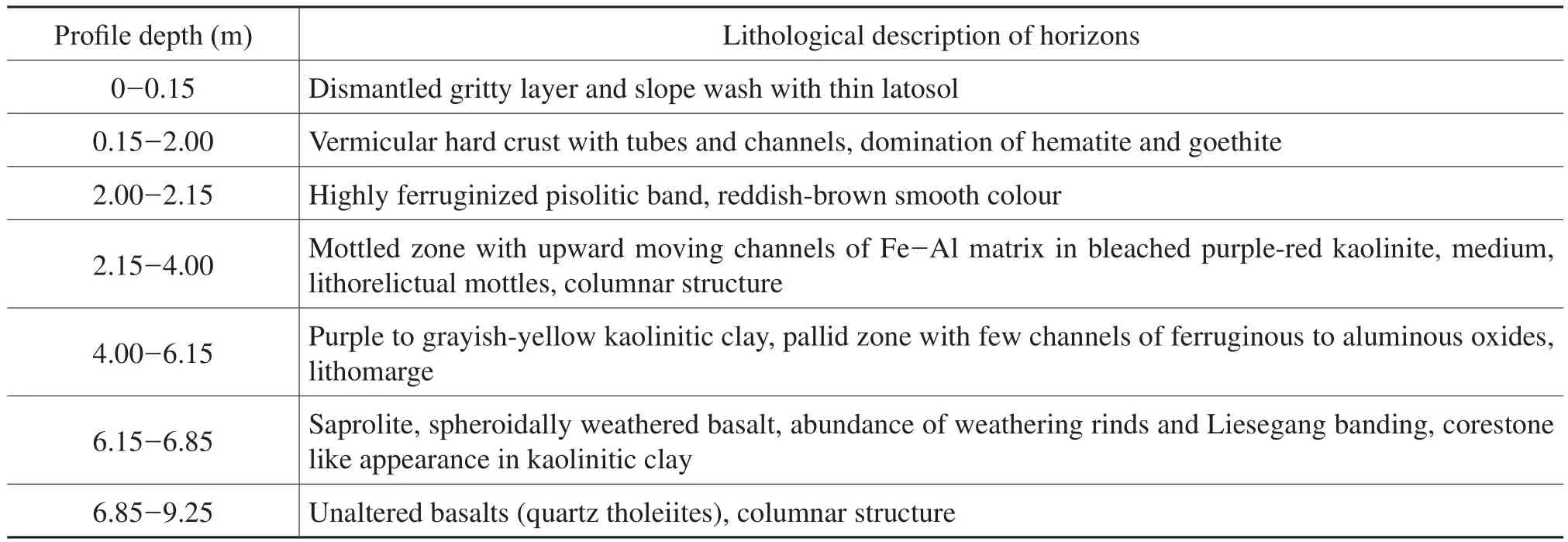
Table 2 Account of in situ laterite log profile at Ghurnee Pahar (24°15’43’’ N, 87°39’11’’E), Birbhum
The Gondwana sequences of Birbhum and Barddha?man districts are characterized by sandstone?clay?china clay?sandstone?coal seams?sandstone and these units are lateritized in some places depicting primary characters. At Pansiuri (23°46’39’’ N and 87°16’47’’ E) 5 m thickin situlaterite profile consists of bedded coarse grain sandstone at the bottom (3.85 to 5 m depth) followed successively by fragmented ferruginized sandstone unit (3.25 to 3.85 m depth), mottle clay horizon with weathered bedded sand?stone (2.4 to 3.25 m depth), pisolitic ferricrete layer (0.5 to 2.4 m depth) with ferruginized red pisolitic band at below.In few places the lateritization of sandstone gives the bed?ded structure of iron hard crust (Figure 4b). The zone of lithomarge (bleached sandstone, unaltered sandstone and kaolinitic clay) varies in depth from 3 to 5.5 m and the glaebular domain (mottle clay with ferruginized sandstone and ferricrete) varies in thickness from 1.75 to 2.5 m.
7.2 Secondary laterite
The low?level laterites separate the lithological forma?tions of Archean, Gondwana and Paleogene gravels from the Sijua and Chuchura Formations (Quaternary alluvium)deposited over the shelf of Bengal Basin between Pliocene and Pleistocene (Das, 1972). The secondary laterites are specifically found as the interfluves in Rampurhat, Illam?bazar, Bolpur, Kanksa, Ausgram, Bishnupur, Garhbeta and Kharagpur though the variations of horizons are still ob?served. The presence of a sub?surface layer of kaolinitic clay reddened from above by ferrocolloids (Biswas, 1987) and of rounded pebbles of different rocks, gravelly appearance of crust and the general absence of conventional horizons of laterite signify a detrital origin (ex situ) inRarhBengal.
Identified profile of secondary laterite
Profile of Boro Pahari, Birbhum:
Based on the field observations in Boro Pahari(24°12’03’’N, 87°41’33’’E), Rampurhat, the following three domains of ideal secondary laterites are identified (Figure 6).
A. Lithomarge or pallid zone.Greyish white to pale coloured soft and porous kaolinitic layer is observed in 5-6.25 m depth. It is overlain on the Paleogene gravel deposits which are appeared as conglomerate of clasts, in?versely- to normally-graded fluvial facies in the medium of bleached kaolin matrix.
B. Glaebular domain
B.1. Mottled zone.Brown to greyish?brown coloured clayey materials with original quartz are observed in 4-5 m depth from the ground surface. Fe-Mn and Fe-Al mot?tles are created in the tubules with kaolinite matrix.
B.2. Duricrust.Crumbly and slag?like, vesicular and porous ferruginous crust is observed up to depth of 0.25-4 m. Red-brown coloured nodules signifies the dominance of hematite, and burned black coloured cortex reflects goe?thite. The most noticeable form of duricrust is centripetal accumulation of iron materials and coarse sands in pores of small size.
C. Dismantled gritty layer.Loose and rounded lat?eritic nodules or concretions or plinthites (0.25 m thick)are dominated the surface of duricrust, signifying the re?cent weathering and pedogenic processes. The presence of iron-stained sub-angular to irregular gravels reflects flu?vial deposits. Under vegetation cover and adequate mois?ture, latosol is developed but on exposure it is hardened.
Profile of Bhatina, Birbhum:
In a quarry of china clay (kaolin) at Bhatina, Birbhum(24°10’02’’N, 87°42’18’’E), a well?developedex situpro?file of laterite is developed over the kaolinite white clay and the ferruginous materials are fluvially derived from thein situhigh?level Rajmahal Basalt Traps’ laterites of western parts (Figure 7). This log profile (Figure 4c) de?picts that laminated massive whitish gray kaolinite horizon(i.e.intensive leaching lithomarge-pallid zone) varies on depth from 3.15 to 4.00 m, having 0.15 m thick ferrugi?nized pisolitic band at top of horizon. Most importantly a horizon of medium? to out?sized clasts (pebbles and grav?els) in bedded kaolinitic medium (including wood fossils and Fe-Al pisolites) is developed at a depth of 1.95-2.10 m. It supports the derived origin and re?lateritization of fluvial sediments. Glaebular domain of pisolitic ferricrete horizon (1.20-1.95 m depth) and re?cemented laterites with remnants of primary laterites with irregular quartz fragments (0.35-1.20 m depth), is developed to depict theex situevolution of laterite profile in northwestern Birbhum district. The surface of this profile (up to 0.35 m depth) carries the slope wash laterite nodules with goethite cortex and iron slag. In few areas of vegetation covers,100-115 cm thick latosol is developed, but in barren areas and gullied land it turns into hard crust due to dehydration on exposure. Importantly this secondary profile of laterite is not directly linked to parent material and this laterite is evolved due to re?lateritization of derived materials over Paleogene kaolinitic clay (Mukherjeeet al., 1969).
Profile of Chatra Krishnanagar, Bankura:
The double profile or poly-profile of secondary later?ite is clearly exposed in the Chatra Krishnanagar Forest,Bankura (23°01’00’’N, 87°311’0’’E). The forested region(Saltree, Shorea robusta) is dissected by the tributaries and gullies of Dwarkeswar River (tributary of Damodar River) and it is one of remnant old forest tracts ofRarhBengal. This profile (Figure 4d) comprises lateritic hard crust with reddish brown latosol cover followed down?wards by thin mottle clay, lithomargic brownish white sandy clay and hard sub?surface laterite. Hard pisolitic laterite with small sized quartz with sandy clay develops at a depth of 3.15-4.15 m. Over this unit, brownish white lithomargic sandy clay (2.9-3.15 m depth) and reddish yellow mottle clay with iron nodules (2.3-2.9 m depth)are developed. The hard laterite of reworked primary later?ite nodules and gravels varies in thickness from 1.15 m to 1.5 m. Reddish brown relatively hard and compact latosol with iron nodules (0.5-1.15 m depth) is the firm base of forest. Below this profile (about 5 m depth) a Paleogene white sand zone is present. This formation of secondary laterite has erosional zone of contact with Early Holocene Sijua Formation (older alluvium with caliches).
Profile of Rangamati, West Medinipur:
In a murram quarry of Rangamati, West Medinipur(22°24’42’’N, 87°17’55’’E), a 11.7 m thick profile ofex situlaterite is developed over the Neogene sedimentary sequences which consist of alternate sandstone-siltstone lithofacies (Figure 4e). This unit is overlain by coarse peb?ble to sand-sized quartz-rich fining-upward ferruginous sediments of Quaternary. But the ideal zone of lithomarge or weathered parent material is not readily observed in this profile. The base is sandstone units of Paleogene which is characterized by cross?bedding with forest dipping around 20° towards 125° (reddish purple colour) and shows high degree of ferruginization and iron?encrustation. The unit of siltstone varies in depth from 8.7-11.7 m and it suc?cessively merged with ferruginized sandstone (5.7-8.7 m depth). And pebble-siltstone bed with iron pisolites (3.7-5.7 m depth). This horizon shows some patchy alumina enrichment separated by a matrix?supported, sparsely?fer?ruginized multi?layered gravel bed of thickness of about 25 cm. Towards top, gravel, large quartz and pebble horizon is ferruginized to a great extent through matrix supported medium, successively overlain by pisolitic porous murram zone and duricrust layer (0.2-3.7 m depth). The duricrust is about 1.5 m thick, vermicular type and constituted of re?cemented gravels, quartz grains and derived primary ferruginous nodules. This profile is overlain by 15-20 cm thick latosol which supports the deciduous vegetation likeSalin this area. These types of laterites are analogous to Early Pleistocene Lalgarh Formation in West Bengal.
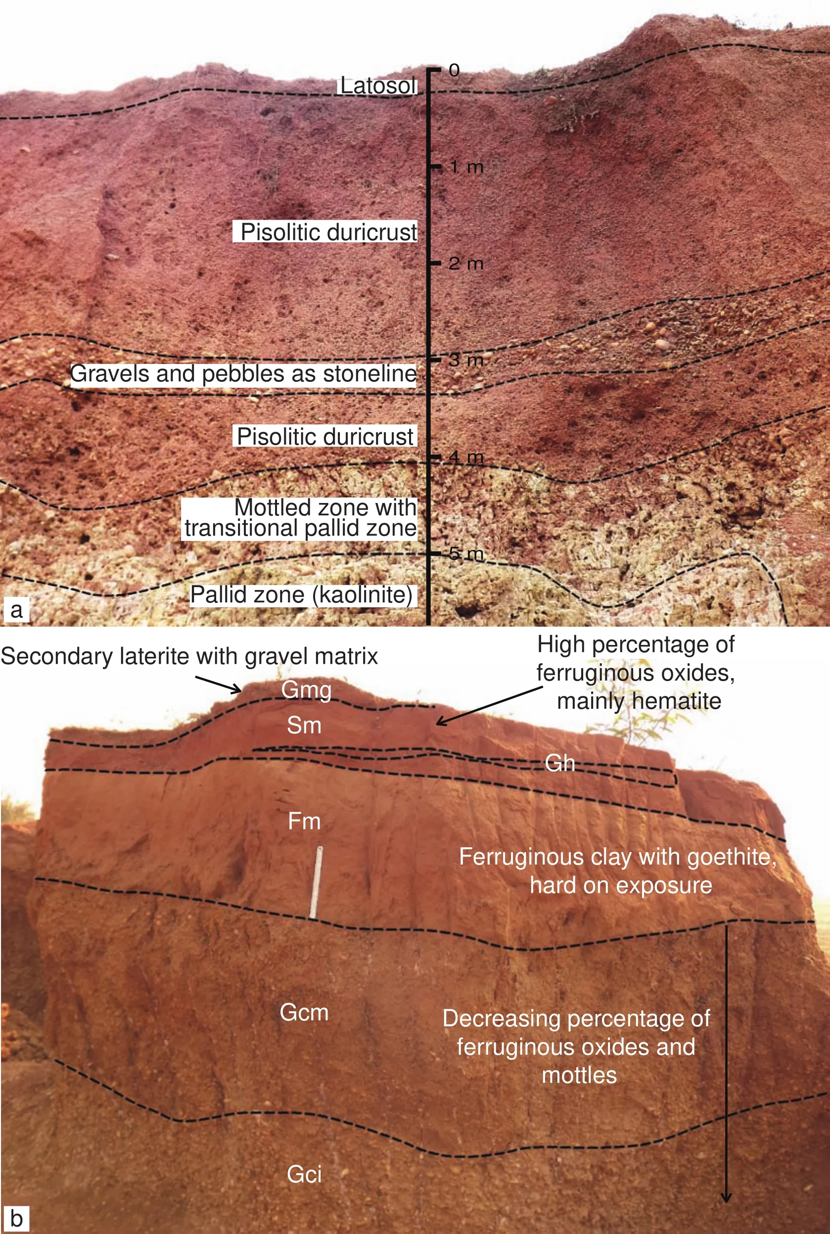
Figure 6 a-Pisolitic duricrust with stoneline of gravels and a transitional mottled to pallid zone (china clay) in the secondary laterite profile (> 5 m depth) at Boro Pahari, western Rampurhat; b-A secondary laterite profile (2.7 m depth) on the Paleogene gravels at Kamalpur, northern Durgapur, having fluvial to debris flow facies (after Mahapatra and Dana, 2009). Gci = Inverse grading clastsupported gravels; Gcm = Clast-supported massive gravels; Fm = Overbank or waning flow clay deposits; Sm = Sand massive or faint wavy lamination; Gh = Clast-supported, crudely bedded gravel; Gmg = Inverse to normal grading matrix-supported massive gravels.Length of scale is 30 cm.
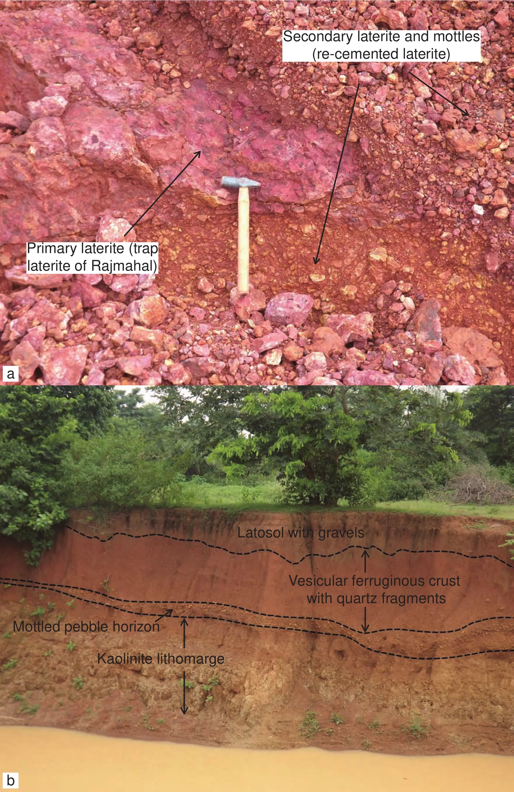
Figure 7 a-Juxtaposition of secondary (re?cemented laterites) and primary laterites (massive and continuous) at Bhatina, Birbhum;b-Profile of secondary laterite and lithomarge at Boro Pahari, Birbhum. Hammer length = 27 cm.
The badland topography (i.e.Khoai landscape) of Bol?pur region (Kopai-Ajay interfluve) has developed over moorum (i.e.friable ferruginous concretions) composed of loosely bounded iron concretions, gravels with a rather thin and hardened surface layer and a brunt blackish red colour. In the badlands of Santiniketan (near Bolpur), the granulometric analysis of laterite hard crust reflects 9.02%of gravel, 54.72% of sand, 20.88% of silt and 14.1% of clay (Mukhopadhyay and Pal, 2009). The soft, brown to grey coloured and iron stained mottled zone (thickness of 1-4 m) is merged with less mottled clayey material (thick?ness of 4-7 m) with no iron concretions in this region(Niyogiet al., 1970). At left Bank of Ajay River, near Il?lambazar Bridge, 1.0-1.35 m thick ferruginous crust is ex?posed due to river shifting. This secondary lateritic surface is developed over kaolinitic clay and siltstone with ample dicotyledous fossil woods (Table 3, Figure 9). The iron cementation is characteristically limonitic and goethitic in the duricrust.
Figure 8 a-Vermicular secondary laterite exposure near left bank of Ajay River, Illambazar, Birbhum; b-Profile sectioning and glimpse of duricrust at Illambazar, Birbhum; c-Eroded remnants of secondary laterite on ferruginized and mottled gravels and pebbles deposits at Hetodoba, Barddhaman; d-Successive occurrences of secondary laterite, ferruginized siltstone with gravels and conglom?eratic beds of pebbles with kaolinite at Hetodoba, Barddhaman.
The lateritic exposure in the Silai-Dwarkeswar inter?fluve (at Bishnupur) is appeared as “l(fā)aterite mesa” (Bis?was, 1987) with 10 m relative relief. The remnants of crust have thickness of 3 m and it overlies on mottled zone and whitish or light yellow kaolinitic pallid zone. In the forest tracts of Durgapur, Kanksa, Galsi, Augram I and II blocks of Barddhaman district (Ajay-Damodar inter?fluve), the hard crust of gravelly laterite is partly eroded by rills and gullies (Figure 8c). Here two distinct layers of pisolitic nodules are identified: (1) loose and less compact?ed gravelly iron concreted zone (70-80 cm thick) and (2)compacted and hard layer composed of regularly spaced nodules cemented by red clayey matrix being ox?blood in colour (Singhet al., 1998; Biswas, 1987).
Spectacular gully development at Gangani near Garh?beta, West Medinipur district, has given rise to a micro?level badland development over the multi?level laterite profile near the right bank of Silai River (Das and Bandyo?padhyay, 1995). Resembling with Australian “breakways”(Biswas, 1987), this scarp?like duricrust is extended up to Kharagpur, appeared as interfluve. The major indu?rated layer (thickness of 2-4 m) consists of red?brown or brick red, hard, vesicular and slag?like porous later?ite in which cavities (tubular) are filled with red-brown or white earthy material (Niyogiet al., 1970; Das and Bandyopadhyay, 1995). This layer is overlain by purple mottled sandy loam (3-5 m thick) and underlain by a pallid zone (10 m thick) with abundance of gravels and coarse sands.
Table 3 Exposure of ex situ laterite profile at Illambazar, Ajay River section (23°36’56’’N and 87°32’07’’E), Birbhum
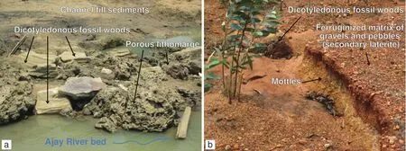
Figure 9 a-Glimpses of dicotyledous fossil woods in porous lithomarge near left bank of Ajay River, Illambazar, Birbhum; b-Dicotyledonous fossil woods with ferruginized matrix of gravels and mottles at Kanksa, Barddhaman.
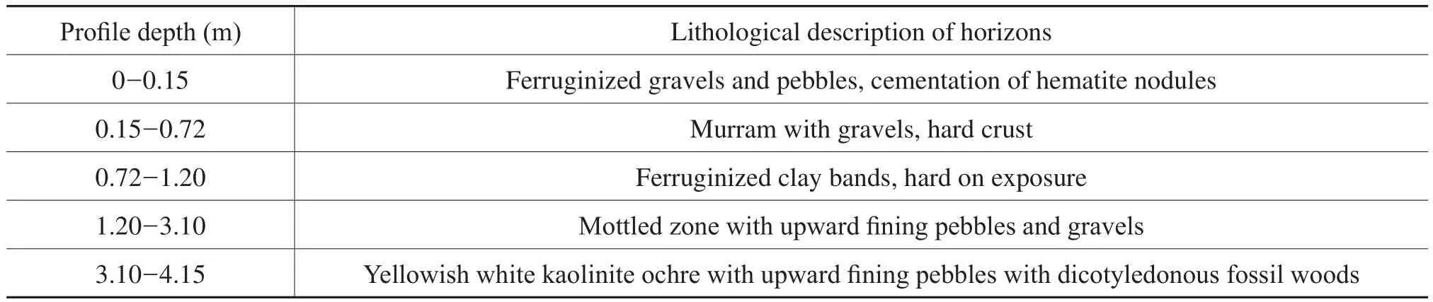
Table 4 Development of ferruginous crust on Neogene gravels and pebbles at Hetodoba (23°26’45’’N and 87°32’07’’E), Barddhaman
8 Processes of ferruginous accumulation
The laterite described by Buchanan (1807) is only one member of laterite families whose members have differ?ent properties but similar genesis (Schellmann, 1981).InRarhBengal the processes of primary and second?ary laterite formation are slightly different in the basis of magnitude of involving factors (i.e.type of weathered materials, source of ferrallitic materials, wet-dry types of climate, fluctuation of groundwater table, topographic positions, stability of favourable environmentetc.). In the tropical geo?climatic settings, the processes of later?itization (transfers of iron), latosolization (residual ac?cumulation of iron), desilication (loss of silica from the profile) and rubification (reddening the regolith and soil horizons with iron oxides) are simultaneously operated to develop distinct horizons of laterite (Schaetzl and An?derson, 2005).
8.1 Movement of iron and silica in the profile
Singer (1975) considered that there are three accepted modes of iron enrichment: vertical leaching, capillary rise and fluctuating water table. Bourman (1993) proposed that lateral migration of iron and aluminium involves the accumulation at preferred sites. The influence of wa?ter table fluctuation has great impact on the lateritization processes. There is no doubt that the change to oxidiz?ing conditions above water table would lead to the oxi?dation and precipitation of ferrous iron (Bourman, 1993;Buttet al., 2000). The high content of Fe2O3(26.2%) and Al2O3(36.71%) in the ferricrete of Nalhati profile signi?fies translocation of ferruginous materials at the duricrust and low content of SiO2(9.76%) reflects intensive leach?ing of silica from the top of profile. Primary silicates are kaolinized in the early weathering stages and most of the alkalis and alkaline materials are removed through leach?ing. In the laminated kaolinitic clay horizon of Nalhati section, the contents of Fe2O3, Al2O3and SiO2are 29.61%,27.17% and 24.3% respectively. Incongruent dissolution of kaolinite with formation of gibbsite occurred over the regolith of basic rocks (e.g.basalt) (Schellmann, 1981).Water does not enter between the successive layers (1:1 layer) of kaolinite crystals, so the kaolinite is non?swell?ing (Tardy, 1992). The occurrence of lithomarge kaolinitic clay between laterite and bed rock acted as perched aqui?fer, influencing the loss of water and free silica through upper slope of kaolinite zone (Goswami, 1981; Ravindran and Kittu, 1981).
8.2 Importance of wet-dry periods
Alternating wetting and drying with the fluctuation of groundwater table, perhaps accompanied by local reduc?tion and reoxidation, is believed to be the main cause of the movement and recrystallization of iron. Our field study of Nalhati, Bhatina and Pansiuri sections reveals that wet period (June to October) directly influences the intensive leaching of silica from the profile, and dry period (Decem?ber to April) influences significant dehydration of Fe-Al oxides including centripetal accumulation of iron nodules.In the areas of secondary laterites (Bankura and West Medinipur districts) the groundwater level (measurements on 433 observation open wells) varies largely from 5 m to 25 m below the land surface (Goswami, 1981). The sea?sonal fluctuation of groundwater table varies significantly from 1.00-10.00 m below land surface of secondary lat?erites. The range of groundwater fluctuation is associated with wet-dry season (seasonal extremity) of monsoon cli?mate and porous nature of ferruginous deposits. According to continual weathering model of laterite formation (Bour?man, 1993, 1995), within the zone of water table fluctua?tion, primary iron minerals within the weathered basement rocks are degraded by weathering under reduction condi?tions, forming ferrous iron that is redistributed and segre?gated within the lithomarge zone to form ferric iron rich mottles under oxidizing conditions.
8.3 Role of ferruginous hydrogels
Pascoe (1964) and Roy Chowdhuryet al.(1965) have emphasized the role of sols and gels in the formation of laterite suggesting that the alumina?rich layer (leached zone) acts as a semi?permeable membrane preventing the movement of iron oxide downwards and colloidal silica upwards. In the wet period the massive ferricretes (i.e.glaebular domains of laterite profiles at Baramasia, Nal?hati, Bhatina and Ghurnee Pahar sections) acts as semi?permeable membrane of Fe-Al sols which can only per?mit leaching of silica and kaolin through channels from the duricrust?mottled layer. The more soluble constituents,both crystalloids and colloids, have been carried away in solution or suspension. Negative and positive sols have each year been precipitating hydrogels of alumina, ferric?ferrous and titanium oxide with silicic acid (Pascoe, 1964).These are dehydrated later due to alternate dry and wet seasons along with fluctuation of groundwater. Suspended matter (gels) has been deposited at the outer base of the laterite profile by spring discharge water and basal sap?ping, as complicated red bands of laminated lithomarge and ferruginous grit (Pascoe, 1964). Large quantities of ferric hydroxides have been forced to that surface from the mottled zone, possibly as results of surface tension, ionic diffusion and capillary pressure as the level of groundwa?ter slow falls (Pascoe, 1964; Roy Chowdhury, 1986; Das and Bandyopadhyay, 1995).
8.4 Centripetal accumulation of Fe-Al oxides
Concretion of iron nodules designates the mechanism of cementation and induration, by centripetal accumula?tion of material, in pores of small size. In a sequence of ferricrete development from mottles (diffuse accumula?tion) to subnodules (nodules with diffuse edges), nodules(with distinct edges) and to metanodules (anastomosed),iron content increases, quartz content decreases drastically(Tardyet al., 1991). Nahon (1986) and Tardy (1992) de?scribed the metabolism of ferricrete: an iron crust is gener?ally built at the top of laterite profile by a combination of successive small?scale migration of iron, leaching or dis?solution of kaolinite and quartz grains, formation voids,secondary accumulation of kaolinite together with small quartz crystals and ferruginization of these accumulations(Figure 10a). In the first case goethite, a hydrated mineral,prevails during a wet season, while in the second case,hematite, a dehydrated mineral, dominates during a dry season. The hematite?kaolinite nodules are rehydrated and corroded at their edges. Kaolinite is dissolved and Al?he?matite is transformed into Al?goethite.
8.5 Successive sequences of ferricrete formation
Based on above discussion, we have found the few im?portant processes of lateritization but there are sequences of these processes, operated to develop the whole profile and hard crust in the favourable tropical climate of lateriti?zation (Figure 10b).
1) In a wet period, the intensive leaching activity and strong chemical weathering of parent rocks produce deeply leached lithomarge which is finally developed into a pallid zone of kaolinite (accompanied with goe?thite) in due course of time. Removal of iron around voids and channels and accumulation of kaolinite form fine saprolite.
2) The formation of mottles (along tubes and channels)is characterized by a contrast between bleached domains of pallid zone and Fe-mottles. Bleached domains of fine quartz and kaolinite exhibit a white or gray colour due to the de-ferrugination which begins at the top of fine sap?rolite. Fe?mottles, brown?red colour, are diffuse glaebules and result in a concentration of iron (goethite and hema?tite) with kaolinite in a dry period.
3) Above the mottled zone, formation of hard crust,i.e.carapace, corresponds to a progressive accumulation of iron and as a consequence, to a progressive development of hematitic iron nodules by centripetal accumulation. The hard ferricrete, purple red colour, is enriched with iron ox?ides in wet phase and is indurated in dry phase continu?ously.
4) At the surface of ferricrete, the hematite?kaolinite nodules are rehydrated and corroded at their edges. Al?hematite is transformed into Al?goethite. A goethite cortex(concentric yellow brown) develops at the periphery of purple?red hematitic nodules.
5) Towards the soil surface, a gritty horizon, made of the weathered products of dismantling of the pseudocon?glomeratic or the pisolitic ferricrete, develops as a com?ponent of ferricrete metabolism. Nodular concentration reflects transfer of Fe-oxides from voids to polarity under the wet-dry periods of tropical climate.
9 Tectono-climatic evolution of laterites in West Bengal
The source of major disagreements as to the origin of these ferruginous formations is to be found in the presence of evidence of residual orin situalteration and weather?ing as well as undoubted detrital or sedimentary features(Roy Chowdhuryet al., 1965). It is accepted that lateri?zation process signifies a particular set of geo-climatic environment, analogous with wet-dry types of tropical climate and it is a common pedogeomorphic process in this climate. Based on previous literatures and geological framework of the Bengal Basin it is hypothesized that the north-south lateritic belt (i.e. RarhBengal) was devel?oped due to (i) drifting of Indian Plate from Gondwana Formation, (ii) onset of monsoon wet-dry climates in Indian sub?continent, (iii) sedimentation of Bengal Ba?sin with peninsular ferruginous sediments and (iv) neo?tectonic movements (Paleogene-Pleistocene) of Bengal Basin (Figure 11).
9.1 Drifting of Indian Plate and establishment of monsoon climate
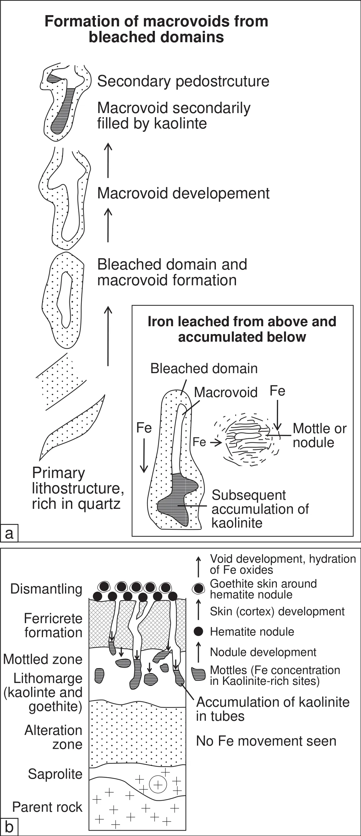
Figure 10 a-An applicable model depicting development of macrovoids with kaolinite and mottles in laterite from bleaching of pri?mary lithostructure (after Tardy et al., 1991); b-A possible adapted model depicting successive formations of lithomarge, macrovoids, Fe mottles, hematite nodules, ferricrete and dismantling of ferricrete in the study area (after Nahon, 1986; Tardy et al., 1991; Tardy, 1992).
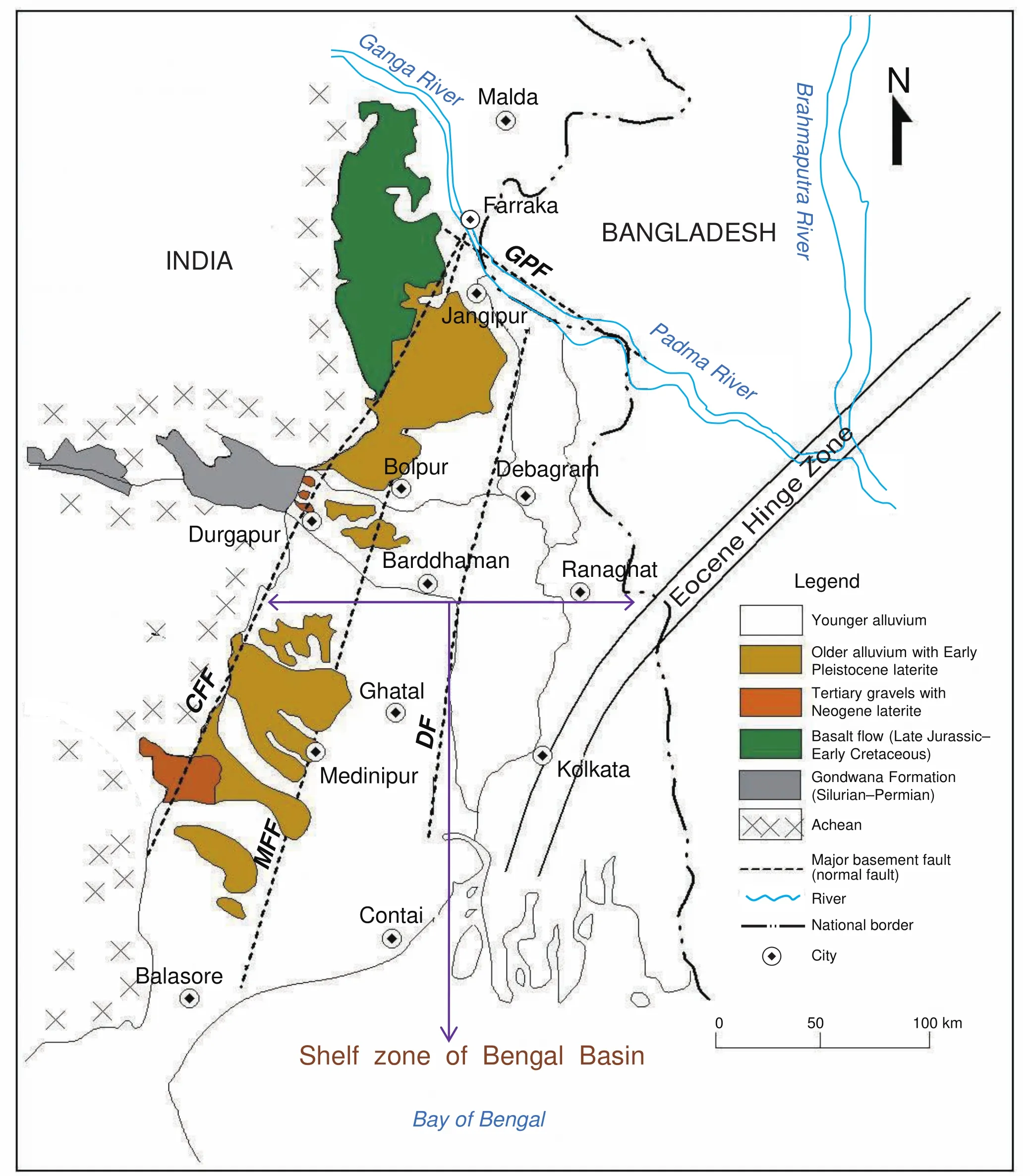
Figure 11 Geological setup of northwestern Bengal Basin (shelf zone) linking Paleogene and lateritic deposits with fault controlled structure (modified from Sengupta, 1972; Singh et al., 1998). CFF = Chotanagpur Foot-hill Fault; MFF = Medinipur-Farraka Fault;DF = Damodar Fault; GPF = Ganga-Padma Fault.
The geomorphic aspects of duricrust formation are the speed at which they form and the rapidity with which they may harden on exposure (Goudie, 2004). It is suggested that the geographical distribution of African, Brazilian,Indian and Australian laterites is correlated with the drift?ing of continents and influence of tropical seasonal climate during the past 150-100 million years (McFarlane, 1976;Tardyet al., 1991; Widdowson, 2004). Following the con?tinental drift hypothesis of Alfred Wegener, it is already established that the climatic zones are stable only when the continents are moved apart from the giant Gondwana Formation. The favourable climatic condition of laterite genesis is characterized by contrasted seasons, high tem?perature, ranging between 28°C and 35°C, annual rainfall lower than 1700 mm and long dry seasons during which atmospheric relative humidity decreases, sometimes be?low 80%. (McFarlane, 1976; Tardyet al., 1991; Tardy,1992; Ghosh and Ghosh, 2003). This type of climatic con?ditions is very much analogous with the monsoon climatic system of India which was gradually established due to equator?ward drift of Indian Plate since 150 Ma (Jurassic Period) and was certainly strengthened by the evolution of Himalayas, colliding with Asian Plate at ~55 Ma (Tardyet al., 1991; Adlakhaet al., 2013).
The date of complete separation of the Indian Plate of the Gondwana Formation from the Antarctic-Australia segment (Figure 12) may be placed in Early Cretaceous(127-120 Ma) (Vaidyanadhan and Ghosh, 1993; Kent and Muttoni, 2008). As rifting widened, a new sea floor was created on which the Indian Ocean entered as Bay of Ben?gal (including Bengal Basin) towards eastern tip of Indian Plate (Vaidyanadhan and Ghosh, 1993). The Rajmahal Volcanics (Late Jurassic) were the earliest manifestation of volcanic activity (followed by Late Cretaceous lava flow in Deccan region, India) which bordered the sea from the peninsular landmass. According to Sychanthavong and Patel (1987) based on the discovery of angiosperm plant fossils, the lower age limit of plateau laterites cannot be older than Late Cretaceous; most likely Paleocene. To as?sign a Cretaceous age, this formation is not plausible be?cause at this juncture the Indian Plate had just started drift?ing apart from its original position between latitudes 40°S and 60° S (more conducive for temperate climate) in the Gondwana Formation (Sychanthavong and Patel, 1987).The Indian Plate was rotated by 40° in an anticlockwise direction in the northern hemisphere and the lateritic belt had crossed the intense tropical zone during this rotation(Sychanthavong and Patel, 1987). If we consider the pal?aeoposition of the Indian Plate and the study area, it is expected that the lateritic region was trending more north?west-southeast (presently north-south) with the align?ment of the latitudinal positions (in between Equator and Tropic of Cancer).
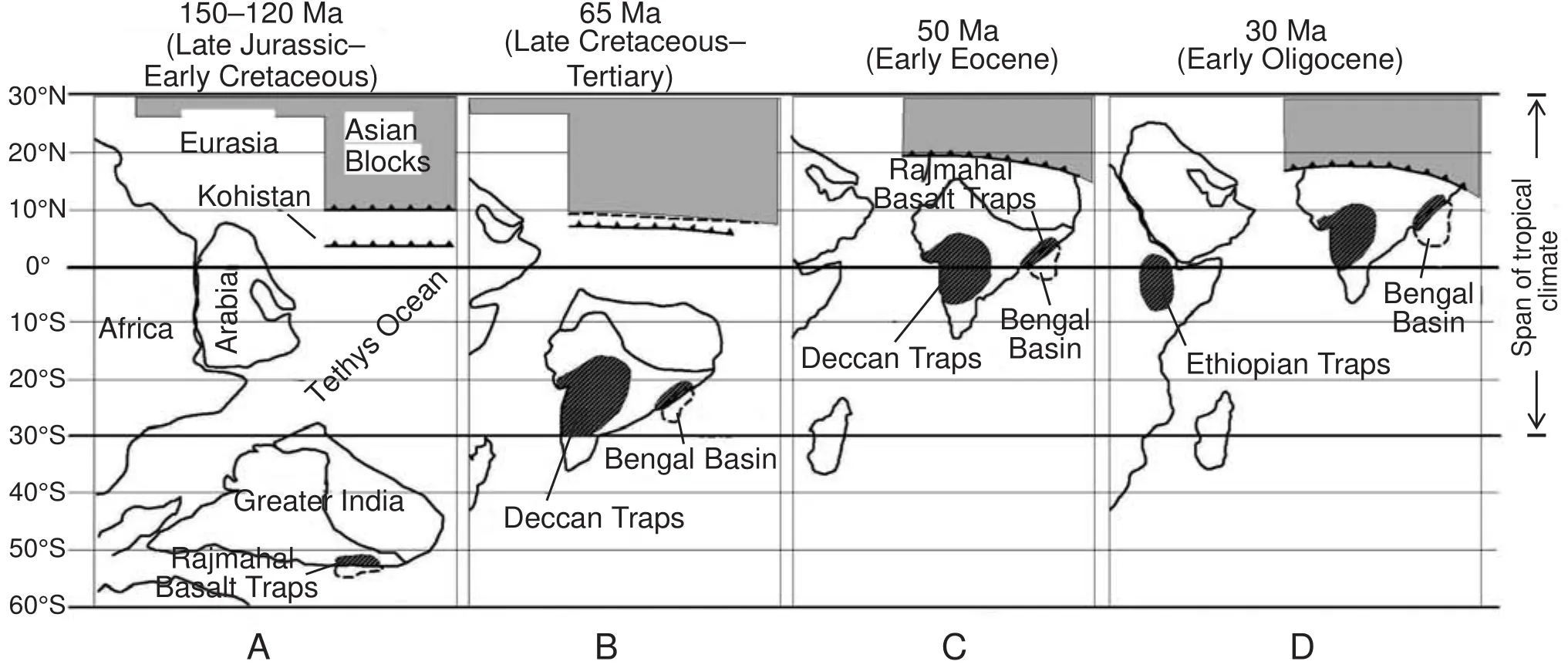
Figure 12 Palaeogeographic reconstruction of Indian subcontinent, Rajmahal Basalt Traps and Bengal Basin and their entry to the region of tropics. A-Separation of Indian segment from Gondwana Formation and emplacement of Rajmahal Basalt Traps in Early Jurassic-Early Cretaceous; B-Reconstruction just after the Cretaceous-Paleogene boundary and emplacement of Deccan Traps; CCollision between Eurasian Plate and Indian Plate; D-Reconstruction for Early Oligocene and emplacement of Ethiopian Traps (modi?fied from Tardy et al., 1991; Alam et al., 2003; Kent and Muttoni, 2008).
During Jurassic times, present day South Africa, greater part of present day Brazilian Shield and Peninsular Shield of India were subjected to arid-semi?arid type of climate(Tardyet al., 1991). Due to movement of plates, the conti?nents of Gondwana Formation were progressively reached towards the zone of tropics but former humid climates pro?gressively become more arid (Tardyet al., 1991). From the end of Triassic to the Cretaceous, the Indian continental climate evolved from hot and dry to hot and humid (Fig?ure 12). Climatic conditions were favourable for intense laterization process from Cretaceous to Paleocene times for during that period, the Indian Plate crossed the zone between 30° S and 0° (Kumar, 1986; Tardyet al., 1991;Devaraju and Khanadali, 1993). After strong collision of India against Eurasia at the end of Miocene, the climate became more tropical less temperate but remained humid with no important arid episode (Tardyet al., 1991). The development of plateau laterites (i.e.primary high?level laterite) began at the end of Cretaceous and continued dur?ing the Paleogene on the surface of Deccan Plateau and Rajmahal Basalt Traps (Sychanthavong and Patel, 1987).Fox observed that possibly no laterization began in Indian peninsula until a monsoon climate was established at the close of Mesozoic (Devaraju and Khanadali, 1993). In the Paduvari Plateau of coastal Karnataka, the occurrences of aluminous laterite or bauxite (5.0-7.0 m thick) underlain by ferruginous laterite (0.5-1.5m thick) signify that cli?mate was evolved from humid tropical to tropical wetdry condition in the Paleogene-Neogene Periods (Tardy,1992; Devaraju and Khanadali, 1993). The deep profiles of primary laterite with ferricrete, observed in the Rajmahal Hills, Ranchi Plateau, Raniganj Coal-field and Singhbhum Shear Zone, were probably developed during Eocene-Mi?ocene Epoch. The prevalence of a tropical to sub?tropical climate during Late Paleocene is borne out by the presence of prolific tropical and sub-tropical flora in the lateritic for?mation of this region (Devaraju and Khanadali, 1993). The dicotyledonous and angiospermous fossil woods are found in the moorum quarries and deep gullies of eastern plateau fringe of Rajmahal Basalt Traps.
The major part of the Indian peninsula falls within Kop?pen’s “Aw” climatic zone (i.e., tropical wet and dry or sa?vanna climate) to which formation of laterite in the present day is confined (Subramanian and Mani, 1981). Consider?ing this reality, the question arises whether all the laterites traced on varied rock types of different ages in Indian pen?insula are to be related to the evolution of monsoon wetdry type of climate which is still active. According to Sub?ramanian and Mani (1981), if stable conditions prevail,then under favourable climatic conditions, the intensity of lateritization processes will be high. So there was a critical balance between tropical climate and tectonic stability in Paleogene times. The present occurrences of low?level lat?erites are the erosional remnants of fossil laterite, indicat?ing the palaeoclimate of laterite (Bourman, 1993, 1995).Clearly there must be a geological time framework (prior to Pleistocene) of India within which the climatically in?duced processes had been operated to form deep profiles of laterites and bauxites on variable parent materials. Frakes and Kemp (1972) completed the continent reconstructions using ocean?current evaluations, oxygen isotope measure?ment and palaeobotanic data and suggested that the cli?mate of Eocene and Middle Oligocene was more favour?able for laterite formation in India peninsula. In Eocene the equator was running across central Gujarat to southern West Bengal (Bardossy, 1981).
The Indian summer monsoon evolved during the Mi?ocene at about ~23 Ma and certainly exited by ~12-20 Ma because increased sediment fluxes were reported dur?ing Middle Miocene (Adlakhaet al., 2013). The monsoon rainfall was again intensified at ~8 Ma ago (Adlakhaet al., 2013). Then the primary and secondary laterites were subjected to severe erosion and the eroded ferruginous ma?terials with gravels and pebbles were deposited by paral?lel river system towards eastward depression of the Ben?gal Basin as the shelf deposits. Then the lateritic uplands and ferruginous soils were gradually developed at eastern fringe of the Chotanagpur-Rajmahal Plateau at the high?est elevation of 35-120 m above mean sea level in West Bengal, separating the Quaternary deposits of the Bengal Basin (Singhet al., 1998).
Development of Paleogene laterites and its episodic ero?sion are confirmed due to existence of ferruginous nodules in different great depths of basin sediments. Due to reac?tivation of basement faults and erosion in palaeomonsoon climates the ferruginous sediments with medium to coarse grain sands and gravels were expected to deposit cycli?cally in the depression of the Bengal Basin as the mon?soon rainfall intensified periodically (Table 5). The base of the Jalangi Formation 6 (Oligocene to Miocene) consists of poorly?sorted medium?grained ochreous, hematitic,lithomargic sandstone with thickness of 119.5 m (Hunday and Banerjee, 1967; Babu, 1981). Again a number of thin bands of laterite have been encountered in Jalangi Forma?tion 7 (Pliocene to Pleistocene) along with gravel, clay?stone and kankar with thickness of 275 m (Hunday and Banerjee, 1967; Babu, 1981).
Table 5 Occurrences of ferruginous nodules in the deep alluvium of the Bengal Basin (Roy and Banerjee, 1990)
9.2 Role of tectonics and ferrugination of shelf deposits
During Paleogene, the Bay of Bengal was reached northwards up to the Garo-Rajmahal Saddle (Vaidy?anadhan and Ghosh, 1993). The whole of the present day Bengal Basin (including Ganga-Brahmaputra Delta) was under water until the Mio?Pliocene Epoch and the strand?line grazed the eastern margin of the Peninsular Shield,i.e.much inland (towards west) from the present day Orissa-Bengal Coastline (Vaidyanadhan and Ghosh, 1993; Das Gupta and Mukherjee, 2006). The western Tectonic Shelf and Barind Tract Horst of the Bengal Basin are separated by the Ganga-Padma Fault (GPF) and the Damodar Fault(DF) separates the Tectonic Shelf and Ganga Fluvio?deltaic Plain Graben (Singhet al., 1998). The Medinipur-Farraka Fault (MFF) within the Tectonic Shelf separates the low?level laterites ofRarhBengal (i.e.upland red soils) in the west from the soils of Bhagirathi-Ajay-Damodar Deltaic Plain in the east (Figures 2, 11). Three successive major faults (north-south trend) extend for variable distances into the overlying Cretaceous-Paleogene sequences and the Lower Gangetic landforms of Bengal Basin had been formed due to reactivation of these faults (Sengupta, 1966;Singhet al., 1998).
The zone of secondary laterites between the Raniganj Coalfield (west) and the Bhagirathi-Hooghly River (east)is recognized as the northwestern delta shelf zone of Ben?gal Basin which is stretched from Farraka in the north to Digha-Haldia coastline in the south (Vaidyanadhan and Ghosh, 1993). Faults of western margin of Bengal Basin are arranged in anen echelonpattern (Sengupta, 1972) and it is possible that this structural zone along the Basin mar?gin behaved as a tectonic hinge (Eocene Hinge Zone) and controlled the depositional conditions throughout the Pale?ogene Period (Sengupta, 1972). Due to intensification of heavy monsoon rainfall (around Paleogene), the western plateau laterites were severely eroded and transported to?wards the break of slope of peninsular landmass,i.e.Cho?tanagpur Foot?hill Fault (CFF). An overall parallel drain?age system (Figure 13a) flowing west to east is a significant geomorphic feature of the plateau fringe of West Bengal,reflecting structural control on drainage pattern and fluvial sedimentation since Miocene (Niyogiet al., 1970). Up to end of Neogene the ferruginous materials were depos?ited by the rivers of Damodar, Ajay, Mayurakshi, Kopai,Brahmani, Dwarkeswar, Silai and Subarnarekha as para?deltaic formation (under shallow marine condition up to Durgapur) in between CFF and MFF (Figure 15b). At 7-6 ka only the eastern Tectonic Shelf (Figures 11, 13b) subu?nit subsided along the Damodar Fault (directed the south?erly course of Damodar River near Palla, Barddhaman district) and was subject to marine transgression (Singhet al., 1998). It favoured subsequent erosion of lateritic uplands and re?deposited the materials towards the down?thrown block with development of Damodar Fan?Deltaic Plain (Acharyya and Shah, 2007). For that reason the few isolated patches of lateritic exposures (compound lateritic profiles) are found at a distance from MFF at Rampurhat,Mallarpur, Labhpur, Bolpur, Guskara, Khandaghosh and Kharagpur, following the fault?line scarp (Biswas, 1987).
During the Early Pleistocene the entire eastern unit of Tectonic Shelf (in between MFF-DF) of the Bengal Ba?sin subsided to become the site deposition and the west?ern unit (in between CFF-MFF) uplifted following the transgression of sea (Figure 15b) (Singhet al., 1998).The Dwarkeswar, Silai and Kasai Rivers have an annular drainage pattern, suggesting relatively active domal uplift around Bishnupur, Garhbeta and Kharagpur (Singhet al.,1998). Sea level gradually decreased and reached their lowest level of ~135 m during the Early Pleistocene around 18,000 years BP, when the Pleistocene and Paleogene sed?iments located in the shelf areas were exposed as relief inversion (Acharyya and Shah, 2010). These deposited ferruginous materials were exposed at the surface, influ?enced by erosion and prolong lateritic pedogenesis under persistent wet-dry monsoon climate. Due to well drainage condition, intensive leaching and chemical weathering (in acidic medium) the top facies of laterites were very much influenced by ferrugination. The tropical wet-dry climate was prevailed in this region up to Paleogene.
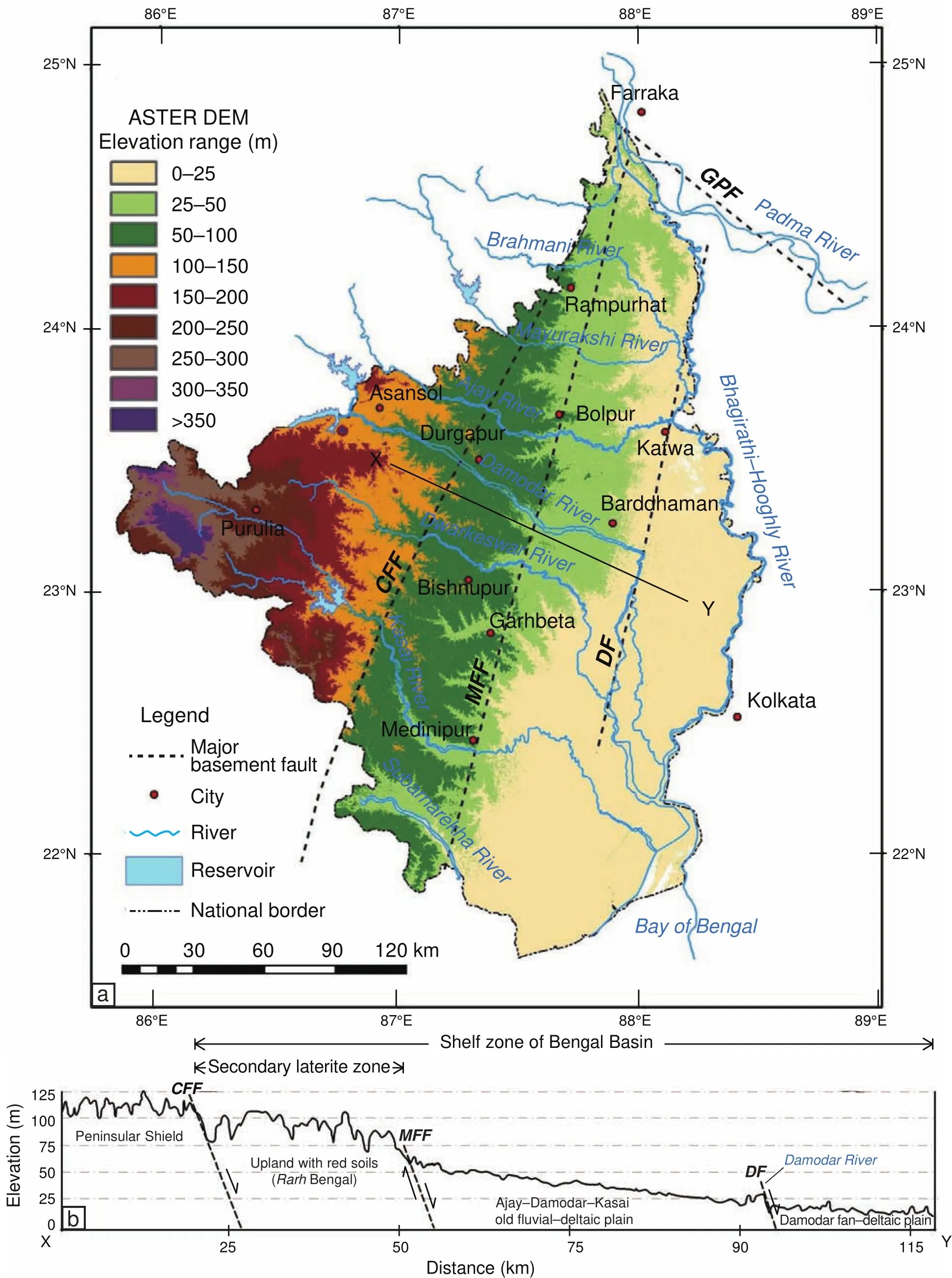
Figure 13 a-Elevation map (prepared from ASTER DEM, 2011) and identified major basement faults (modified from Singh et al.,1998) in the western part of the Bengal Basin; b-West-east cross profile (X-Y) with emplacement of faults. The lateritic Rarh region of Figure 1 is bounded by Chotanagpur Foot?hill Fault (CFF) at west and Medinipur-Farraka Fault (MFF) at east. CFF = Chotanagpur Foot-hill Fault; MFF = Medinipur-Farraka Fault; DF = Damodar Fault; GPF = Ganga-Padma Fault.
Because dicotyledonous fossil woods (probably Mio?cene-Pliocene age) are still found in the lateritic forest tracts of Panagarh and Ausgram, Barddhaman district(Hunday and Banerjee, 1967). The lateritic topographic level (50-120 m above mean sea level) represents reworked laterite and contains vertebrate fossils of Middle-Early Pleistocene age along with the palaeolithic tools (Vaidy?anadhan and Ghosh, 1993). The nodular ferruginous soils or Upland Red Soils (after Singhet al., 1998) observed under the forest covers of West Bengal could appear to be relics of ancient ferricretes which developed when these areas were subjected to a contrasted tropical climate but which are now being destroyed under very humid tropical condition that prevails today. Increased precipitation dur?ing the ~15-5 ka period of monsoon recovery probably increased discharge and promoted incision and widespread badland formation (i.e.Khoai landscape in West Bengal)(Sinha and Sarkar, 2009). Observing the western parallel drainage pattern of West Bengal and extent ofRarhBengal it is clearly observed that the lateritic uplands are now ap?peared as the dissected interfluves which were once as the valleys of ferruginous deposition (i.e.earliest fan deposits of the Bengal Basin), now appeared as inversion of relief(Biswas, 1987; Bourman, 1993; Ollier and Sheth, 2008)due to tectonic uplifts, re?lateritization and incision of riv?ers. The dominance of kaolinite (with presence ofHystrichospheridsin the spores of clay beds in Birbhum district)indicates lacustrine to fluvio-lacustrine condition of depo?sition in Paleogene (Mukherjeeet al., 1969).
The age of the whole Indian laterites decreases from north to south in concordance with the drift tectonic history of the Indian Plate across the equator (Sychanthavong and Patel, 1987). So the primary laterite over Rajmahal Hills must be older than the laterite of Western Ghats. According to Niyogi (1975) the eastern lateritic soils ofRarhBengal(i.e.Lower Lalgarh Formation), older deltaic plain (i.e.Sijua Formation) and younger deltaic plain (i.e.Chuchura Formation) (Figure 2) have been assigned ages of 350-1000 ka, 175-275 ka and 60-82 ka respectively. Singhet al.(1998) suggested that the red soil groups ofRarhBengal are the oldest soils from the Indian part of these Gangetic Plains. In the Durgapur Depression (Kumar, 2006), the fer?ruginous concretions (Pliocene) were formed over deposit?ed gravels which is probably Oligocene to Miocene in age(Das, 1972; Beraet al., 1996). The presence of Younger Toba?Ash Bed Marker (~75,000 yrs BP) has been recorded from basal parts of the Quaternary profile from the Brahm?ani and Barakar River sections, located west of the Bengal Basin margin (Acharyya and Shah, 2010). These beds are tentatively correlated with the lateritic unit which may be assigned Pleistocene age (Acharyya and Shah, 2010). Ac?cording to Morgan and McIntire (1959), the Late Pleisto?cene ferruginous sediments are found principally in four areas of the Bengal Basin: (1) east of the Rajmahal hill system (i.e. RarhBengal), (2) Barind tract, (3) Madhupur jungle, and (4) west of the folded Tripura system.
Near surface occurrence of lateritic conglomerate(Gmg facies-matrix?supported massive gravels, inverse to normal grading) is the product ofex situlateritization of debris flow-fluvial deposits during Pliocene to Early Pleistocene (Mahapatra and Dana, 2009). It is comparable to Early Pleistocene Lalgarh Formation (West Medinipur district), Saltora Formation (Bankura district), Illambazar Formation (Birbhum district), Kharagpur Formation (East Medinipur district) and Worgram Formation (Barddhaman district) (Vaidyanadhan and Ghosh, 1993). These forma?tions can be considered as the palaeoclimate proxies of strong tropical wet-dry climate which is prerequisite for the development of ferruginous concretions. In this region the lateritization process was favoured by the following factors (Niyogiet al., 1970; Biswas, 1987; Singhet al.,1998):
1) Onset of monsoonal rainfall with prolonged dry months (Late Eocene-Early Pleistocene) to accelerate sub?aerial chemical weathering in the derived ferruginous matrix;
2) Uplifted block (in between CFF and MFF) and its influences on seasonal groundwater regime, sub-aerial exposure, strong leaching, irreversible dehydration, well sub?surface drainage and prolong erosion;
3) Adequate permeability and drainage condition to permit deep percolation of silica and deposition of iron ox?ides as coating over gravels;
4) Warm and strong seasonal climate to hasten the chemical breakdown, hydration and dehydration of fer?ruginous and aluminous oxides; and
5) Prolonged quiescent phase of geological time with permanent regression of sea level (Late Miocene-Early Pleistocene) from this area.
A feedback loop is inherent in the development of re?sidual and detrital laterite cover, because lateritization and erosion are continuous cyclic processes since Eocene(Karunakaran and Sinha Roy, 1981). The loop involves lowering of primary laterite profile for accentuation of weathering and consequent accretion and subsequent up?lift for facilitating erosion, re?lateritization, stripping, and etchplain formation (Figure 14).
10 Conclusions
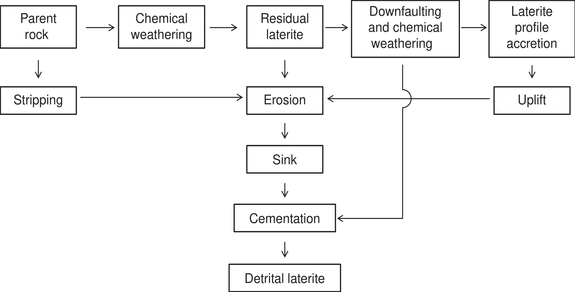
Figure 14 A possible feedback loop to depict sequential development of primary and secondary laterites in the monsoon climatic setting.
It is finally understood that three basic conditions must be met before enough iron oxide accumulates or segre?gates to form crust: (1) adequate supply of iron, (2) alter?nating wet and dry seasons, and (3) iron segregation and accumulation for appreciable periods. It is suggested that the development of both pallid zone and mottled zone is one integrated process and the formation of ferricrete or crust is the final result of that integrated process. If we ac?cept the residuum theory of laterite formation, the original iron precipitates are believed to have formed in the narrow fluctuating range of a groundwater table, which declines as the land surface is lowered. With the cessation of down?wasting and stabilization of the groundwater table, the ferruginous residuum is thought to have been hydrated to form massive laterite. The mottled zone is formed with the absolute accumulation of iron in kaolinized matrix involv?ing the epigenetic replacement of kaolinite by hematite.Soft nodular and hard nodular iron crusts are described in the upper part of profile that involves the transformation of soft yellow plasma into pisolites. As surface weather?ing and erosion proceeded, the iron segregations, largely as hematitic mottles with goethite rinds, are progressively exposed at the surface, where they are hardened.
Only the profiles of laterite on Upper Jurassic Ra?jmahal Basalt Traps have massive appearance (in situweathering) reflecting vermicular lateritic hard crust (i.e.primary laterite), mottled zone with lithomarge clay and deeply weathered basalts. It is suggested that these prima?ry laterites started to develop in between Late Cretaceous and Eocene. But if we go southwards and eastwards, a ploy-profile of laterites with an intervening erosional surface and original gravels (with iron staining) are pre?sent, gradually merging with mottled clay zone and Sijua Formation (Late Pleistocene to Early Holocene). These laterites are identified as the secondary laterites (products ofex situweathering) which were derived from the pri?mary laterites of western Chotanagpur Plateau, Raniganj Coalfield and Rajmahal Basalt Traps towards the Bengal Basin. Due to exposure, well drainage condition and pro?long monsoonal wet-dry episode, the indurated laterite or consolidated gravely lateritic mass or vesicular or pi?solithic laterites were formed at the surface in different parts of northwestern Bengal Basin. Geomorphologically these laterites are found here in two settings (1) as contin?uous crusts on plateau fringe where they act as hard caps on the table?like landforms and source of ferrallitic ma?terials, and (2) at footslopes and interfluves as deposited ferruginous crust, in seepage areas where reduced iron in soil solutions encounters oxidizing conditions and pre?cipitates. The most noticeable feature of southernRarhBengal is the presence of a ploy-profile or multi-level lat?eritic hard crust. It is assumed that bottom profile formed earlier from Paleogene gravelly sediments and after sub?sequent regional uplift and subsequent erosion developed upper profile of ferruginous alluvium deposits which were lateritized in Late Pleistocene. The age of whole Indian Paleogene-Neogene laterite decreases from north to south in concordance with the drift tectonic history of the Indian Plate across the equator. So the establishment of strong seasonal monsoon climate (since Eocene), due to equatorward drift and evolution of lofty Himalayas,created favourable conditions for the development of plateau laterites (Eocene-Miocene) which were subse?quently eroded, deposited and re?lateritized in the valleys within the span of that seasonal climate (Pliocene-Early Pleistocene).
Acknowledgements
We are very much thankful to Suvendu Roy (JRF, Ge?ography Department, University of Kalyani, West Bengal,India) and Subhankar Bera (Researcher, Geography De?partment, The University of Burdwan, West Bengal, India)for their rigorous all-round supports in the field study. This work was supported by the Department of Geography, The University of Burdwan. In publishing this work, we are indebted to obtain kind attention and cooperation of Prof.Zeng?Zhao Feng (Editor?in?Chief,Journal of Palaeogeography). Alongside the comments and suggestions of re?viewers are found to be very much helpful to enrich this work in a scientific way. Most importantly we are obliged to the China University of Petroleum (Beijing) andJournal of Palaeogeographyfor providing us a great platform of publication.
 Journal of Palaeogeography2015年2期
- Journal of Palaeogeography的其它文章
- Mesozoic basins and associated palaeogeographic evolution in North China
- Geodynamic evolution of the Earth over the Phanerozoic: Plate tectonic activity and palaeoclimatic indicators
- The landslide problem
- General regulations about submitting manuscripts to
- 2nd International Palaeo?geography Conference October 1013, 2015 Beijing, China First Circular
- Summary of the 1st Editorial Committee Meeting of Journal of Palaeogeography in 2015