
A discussion on improving typhoon observation through radar by scanning the negative elevation angle
2014-12-19 08:39:20BaLinXuShaoHuiMiaoLiPingLiuChangDaoWuGaiLiWang
BaLin Xu ,ShaoHui Miao *,LiPing Liu ,ChangDao Wu ,GaiLi Wang
1.The Emphasis Opening Laboratory of Atmospheric Sounding,China Meteorological Administration,Chengdu,Sichuan 610041,China
2.The State Key Laboratory of Disaster Weather,Chinese Academy of Meteorological Science,Beijing 100081,China
3.Yunnan Meteorological Administration,Kunming,Yunnan 650034,China
1 Introduction
Typhoons are one of the main meteorological disasters in China.Meteorologists have always regarded typhoon research as an important topic to focus attention on.The weather radar has become an essential means of typhoon detection and prediction,used to understand and grasp typhoon movement.Domestic and foreign scholars have researched this topic extensively.The research subject was organized into a national scientific and technical key task,categorized as 85-906-07,during 1991–1996 in China,with special topics including typhoon science,operational experiments and synoptic dynamics theory.A domestic tropical cyclone scientific experiment of the acronym CATEX(i.e.,China Abnormal Typhoon Experiment)(Fan,1996)was developed in summer during 1993–1994.Eight typhoons of forthcoming coastal landing were selected as object experimental typhoons,and from the study of these typhoons,a significant amount of ground intensive data and radar and satellite data were obtained.Chen(1993)introduced a series of typhoon field scientific experiments which were developed in the northwest Pacific Ocean in the early 1990s,such as the intensive observation of the initialism TCM(i.e.,tropical cyclone movement),TYPHOON,CATEX(i.e.China Abnormal Typhoon Experiment),SPECTRUM(i.e.,special test to redirect and unusual movement typhoon)experiment to obtain the detailed intensive observation data of the typhoon’s internal environment and the characteristics of the surrounding atmosphere and ocean.Chenet al.(2004)analyzed a series of field scientific experiments which domestic and foreign scientists had carried out based on the development of current atmospheric sounding technology.The results showed that if the digital data of the satellite remote sensing and radar echo could detect the main features of typhoon structure,the forecasting capability for typhoon movements would be significantly improved.With the construction of the next generation weather radar net,we have more advanced detection means.By using the important characteristics of NEXRAD(i.e.,Next Generation Weather Radar)detection,Weiet al.(2007)had proved that wind field distribution of the typhoon area followed the asymmetry of the wavenumber as one and indicated that the joint detection of the dual-doppler radar and the multi-doppler radar were advantageous for the typhoon watch forecast.Weiet al.(2008)made full use of radar to detect the asymmetrical distribution of extreme positive and negative radial velocity near the core radius of the typhoon Chanchu,and had proved that the middle and low level northeast air currents to the left of the typhoon’s forward trajectory entered the vortex of the typhoon.Zhuet al.(2005)analyzed the detection data of the typhoon Rananim and its findings,and discussed the Z-I relationship of typhoon precipitation.Zhaoet al.(2008)explored typhoon nowcasting technology based on radar by the cross-correlation method and the centroid tracking method,according to the tape helix structure of the main echo.Zheng and Zhang(2006)analyzed and explored the falling area of torrential rain for the code 0601 typhoon Chanchu with the physical quantity diagnostic analysis method according to the spatial-temporal high resolution characteristics of radar data.Fenget al.(2001)calculated and analyzed the statistical features of radar echo,stratified thermal parameter and precipitation in the Tibetan Plateau,according to ground based radar,sounding and surface precipitation data of the Plateau in 1998.Fuet al.(2007)analyzed and researched strong convective precipitation cloud clusters caused by a special topographic channeling of the southeastern Tibetan Plateau employing extensive new data.Zhenget al.(2010)analyzed some factors of the strong tornado Sepat such as the reflectivity factor,vertical wind shear and relative windstorm radial velocity according to Doppler radar detection.Zhenget al.(2009)analyzed radar echo characteristics of three severe tornadoes and evaluated their differences with a supercell storm with severe hail using Doppler radar data.Guoet al.(2005)analyzed the torrential rain process caused by the Imbudo typhoon and studied the features of the small mesoscale system,such as areas with head wind,cyclonic convergence,and areas with high wind and persistent warm advection which were noticeable in the Doppler velocity field.Zhanget al.(2007)analyzed the synoptic situation,the features of water vapor transfer,the cloud system development features,and the unstable atmospheric condition of heavy rainfall over a large range caused by the landing of the typhoon Haitang.Huanget al.(2009)conducted a contrast analysis between Doppler radar echo characteristics and the small mesoscale system of the immense storm caused by the Bilis typhoon.Xu MLet al.(2006)conducted a numerical simulation analysis for a storm landing off the Bay of Bengal using a MM5V3 mesoscale numerical model,and discussed storm center tracks,the structure of the flow field,the dynamic field and the thermodynamic field before and after the storm’s landing.Continuous progress had been made in understanding typhoons,aiming towards human protection,based on the above studies.
However,current meteorological operations and the above studies are usually based on the conventional detection model VCP11 or VCP21 of radar and its lowest elevation angle is 0.5°.This elevation angle is used to decrease the influence of ground objects on typhoon examination,but at the same time,it affects the radar detecting capabilities of remote low echo surveillance for typhoons.The negative elevation angle in this paper refers to those below the lowest elevation angle of 0.5°,and some domestic and foreign studies have been performed using the detecting means of the negative elevation angle.Wetzelet al.(2004)presented some problems such as the disadvantages of reduced detecting capabilities of low-level echo with the lowest elevation angle of 0.5° for mountaintop radar through researching mesoscale snow of mountainous areas.Brownet al.(2000a)described some deficiencies in the radar system,such as the imperfect detecting capabilities of remote low-level echo surveillance with the lowest elevation angle of 0.5° of VCP11 and VCP21,in distinguishing the features of severe storm.Brownet al.(2000a)also contrasted the vertical scanning sampling with the VCP21 detecting data used generally at present to analyze the potential inaccurate results.Brownet al.(2000b,2002c)put forward some proposals for using the negative elevation angle as an approach to improving the detecting capabilities of low-level radar echo by simulating the detecting effects of different weather situations with a negative elevation angle,and by contrasting the detecting methods with the elevation angle of 0.5° and negative 0.8°.They pointed out that the negative elevation angle could improve the detecting capabilities of mountaintop radar.By case validation,the negative elevation angle improved the detection capabilities of scans of low-level severe weather around the valleys as well as the total precipitation of radar-derived coverage areas.8%–15% precipitation estimation could be improved when the rain intensity was assessed in a case.And at the same time,researchers studied and demonstrated that detecting remote low-level echo with a negative elevation angle of radar was still a complicated problem and a challenging job.
The results for mountaintop radar have showed that the low-level echo status was difficult to understand when the detection height was over the boundary layer and the high beam of remote radar(Wetzel,2004;Xuet al.,2008),because the sea level elevation and the conventional detection mode of mountaintop radar limited the detection range.This was the case for remote detecting for typhoons as well.There has been no meteorological operational application with a negative elevation angle of radar in China at present.It is necessary to improve the radar scanning mode,typhoon warning and prediction,and further,to discern the developing mechanism of severe weather by discussing detecting typhoons with a negative elevation angle.As the NEXRAD detecting network has been gradually put into operational service,the conventional radar detection data increased dramatically.An important problem may be obtaining non-conventional detection data by special observational methods used to understand the typhoon structure and to improve the prediction and warning for typhoons.Based on the negative elevation angle typhoon data in Changle Radar Station of Fujian Province,some characteristics of typhoon detection with a radar’s negative elevation angle were discussed and data analysis for detecting typhoons with a negative elevation angle were conducted in the following examination,by comparative analysis of data between the conventional detection angle and the negative elevation angle of radar.
2 Basic status of radar and general situation of typhoons
The Changle radar of the type SA-88D,a NEXRAD of S wave range with an operational distributed point in China,is located on the Shipin mountain of Fujian Province with the antenna altitude is 650.6 m.The Changle radar conducted a more complete contrast evaluation for the two severe typhoons Haitang and Changmi by the means of conventional observation and negative elevation angle detection.The conventional observational data provided good basis for a forecast service and short-time warning,while the acquired echo information of negative elevation angle provided materials for research.During a typhoon weather process,the operational scanning mode VCP11 was used to obtain the data of the elevation angle of 0.5°,and its distance was 1,000 m,with 512 radial lines found by scanning a period.The sampling time was the fixed intervals of the continuous volume scan.The same parameter in the PPI scanning mode was set for the negative elevation angle.If the elevation angle of the antenna was decreased by 0.12° through the use of a mechanical method,the lowest level detecting elevation angle of radar was 0.38°.Thirty-eight volume scan data were discussed with statistics and analysis based on the comparison of adjacent volume scan data before and after decreasing the antenna angle.
The severe typhoon Haitang reached the Taiwan Strait at 22:00 on July 18,2005 and stayed at the sea level of thirty kilometers in southwestern Xinzhu.The maximum wind force around the center was 12 grades(40 m/s).After it reached the Taiwan Strait,the typhoon center moved northwest by west at 15–20 km/h and landed in July 19 on the Fujian coast.
The fifteenth tropical storm to be discussed,Changmi,was generated on the sea surface of the eastern Philippine on the night of September 24,2008.In the early hours of September 26,Changmi became a typhoon,and in the afternoon,it turned into a severe typhoon.By the morning of September 27,Changmi had become a super typhoon.Changmi landed at 03:40 on September 28 near Nan’ao in Yilan county of the Taiwan Province.The maximum wind force was 16 grades(51 m/s)in the center upon landing.It was the strongest typhoon of the year in China.
3 The detecting feasibility of the negative elevation angle of radar
3.1 The remote detecting range with radar’s negative elevation angle
The relationship among the detection of radar echo height,radar height,elevation angle,distance and earth curvature had been analyzed by Xuet al.(2011).The interrelation of these factors was observed in the studied typhoon.
3.2 Feasibility analysis of the influence of objects on the ground on radar detection with a negative elevation angle
Shelter of ground objects should be considered when the negative elevation angle of radar is used for detection.As long as the shelter of objects on the ground was small,the weather system could be better observed.Taking the 150 km range of the Changle radar station as the center in figure 1a,according to the radar shelter angular chart of ground objects from geographic surveying and mapping information,the shelter of ground objects was not serious except for an individual isolated obstacle in north-northwest direction at the elevation angle of 0°.More shelter of ground objects occurred only at the elevation angle of negative 1°,and this showed that it had a clearance setting at the elevation angle from 0° to 0.5°.
Due to the influence of radar side lobe,ground echo still occurred,affecting the radar detection with the negative elevation angle on the smaller scale.Radar detection data of clear air showed as following.Figure 1b displays the detection intensity chart of clear air for the elevation angle of 0.5°.Each range loop was 50 km within 200 km in the radar echo chart,with a stronger echo of ground object on Taiwan Island,and enhanced echoes in other directions.Figure 1c is the detection intensity chart of clear air for the negative elevation angle of 0.38°.There were few ground echoes of significant influence in the range of 180 km,and no ground echoes of any influence between 180 and 300 km except in the direction of Taiwan Island.On the whole,the influence of ground object echoes for the two elevation angles formed across Taiwan Island had a great effect beyond 180 km.The ground echo intensity for the negative elevation angle of 0.38° was greater than that of the conventional elevation angle of 0.5°.Thus,selecting the negative elevation angle of 0.38° as a means of detection was feasible because radar detection was not affected by severe ground echoes nor by side lobe echoes with the conventional elevation angle of 0.5° and the negative elevation angle of 0.38°,except with Taiwan Island of the southeast sea plane.
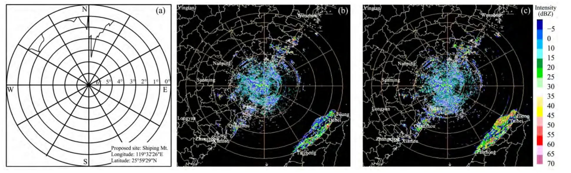
Figure 1 The radar data contaminated by ground clutter.(a)Occluding angular chart of ground object in Changle radar station;(b)Detecting intensity chart of clear air for the elevation angle of 0.5° at 230 km;(c)Detecting intensity chart of clear air for the negative elevation angle of 0.38° at 230 km
4 The echo characteristic analysis of basic reflective index for detecting the Haitang and Changmi typhoon with a negative elevation angle
Based on the feasibility established above,if the antenna angle was decreased by 0.12° using a mechanical method,the elevation angle of 0.5° in the control software of the radar,which was set in the first level of PPI,became the negative elevation angle of 0.38°.The scanning method above the second level was increased systematically according to VCP11 elevation angle.
4.1 Comparative analysis of the basic characteristics of radar echo with the detection means of negative elevation angle for the typhoon Haitang
At present,radar data plays an important role in understanding typhoons.Changes in the number of clouds as well as alterations in the microphysical variate related to vapour could be described quantitatively,in detail,by the radar reflectivity data.This is one of the most important specialties of NEXRAD.A more complete comparative observation of negative and conventional elevation angle was conducted by NEXRAD in the Changle station when the severe typhoon Haitang approached the Taiwan Strait on July 17,2005.Figure 2a presents the basic reflectivity for detection with conventional elevation angle of 0.48° at 14:47 on July 17,2005.Figure 2b displays the basic reflectivity for detection with the negative elevation angle of 0.310 at 14:55 on July 17,2005.Each range loop was 100 km within 400 km on the radar echo chart.The following differences could be clearly seen from the two data comparisons.
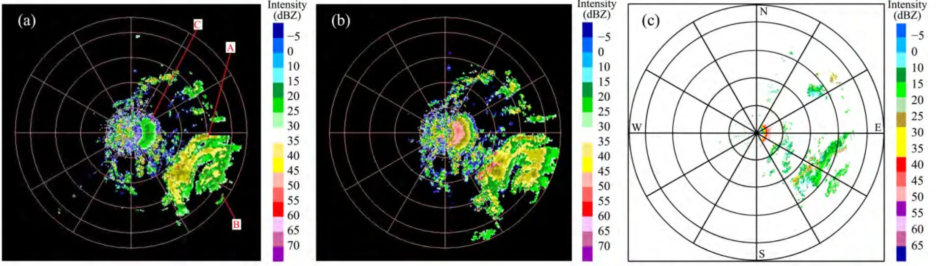
Figure 2 The radar data before typhoon Haitang landing.(a)Basic reflectivity of the elevation angle of 0.48° at 460 km;(b)Basic reflectivity of the elevation angle of 0.31° at 460 km;(c)Echo difference of two levels
First,a region of figure 2a exhibits the radar echo of the main body of the Haitang typhoon in general.The corresponding region of a negative elevation angle in figure 2b had a greater and wider typhoon echo than the echo chart of the conventional elevation angle of 0.5°.This region also showed more echo areas which were larger than 35 dBZ.The B region of figure 2a displays the location of typhoon eye.The convective cloud masses inlayed in the eye wall of the typhoon were greater in number and clearer to behold.The echo intensity of the two detecting methods was inhomogeneous in spatial variation.However,the continuity of strong echo with the detection of negative elevation angle was better.Contrasting the two charts,the distribution of the convective cloud mass was more complicated and most of the cloud masses had the resulting structure of an echo band.The intensity varied from 35 dBZ to 55 dBZ while the detection with the negative elevation angle resulted in more echo.Table 1 shows the distribution condition of the range bin for the reflectivity factor on the two different elevation angles.The distance which was more than 100 km indicated typhoon echoes and that which was less than 100 km indicated sea echoes.The range bin number of the basic reflectivity factor beyond 100 km for the elevation angle of 0.31° was 6.2% more than that of 0.48° from table 1.The data for the decreased elevation angle further revealed the distribution of maximum reflective factor,while also revealing the strongest echo region of the windstorm in the entire detectable atmosphere.
The basic reflectivity factor for the detection of the elevation angle of 0.31° contributed to the detection of the typhoon’s intensity and its structure characteristics.The windstorm synthetical information tables such as DBZM(i.e.,maximum reflectivity),HT(i.e.,maximum reflectivity developing to 50 dBZ),TOP(i.e.,high echo top),FCSTMVMT(i.e.,storm forecast movement),VIL(i.e.,vertically integrated liquid water)could be evaluated for the important reference data for the windstorm vertical structure compared with the elevation angle of 0.48°.Clearly,the negative elevation angle detection could help us understand the low level status of a typhoon more completely and precisely,and would be helpful for further analyzing the low level structure of the typhoon precipitation cloud.
Table 1 Statistics of reflectivity factor at the elevations of 0.48° and 0.31°
Second,figure 2c presented the difference of the reflectivity factors at the elevation angles of 0.31° and 0.48°.Table 2 qualitatively exhibited the distribution or the difference of the reflectivity factors and also showed that the reflectivity factors of more 10 dBZ had up to 5,848 range bins,among which reflectivity factors of more than 30 dBZ had 1,530 range bins.The comparison was conducted under the condition of minimal changes with two detection echoes every 8 minutes.The results showed that the radar at the elevation angle of 0.31° could detect more precipitation echoes than that at the elevation angle of 0.48° for now,and that the detecting range came up to nearly the bottom of the typhoon.It was a great improvement from the conventional scanning mode.Sea echoes were mainly distributed in the distance closer to the radar,and the rest were typhoon echoes if the influence of sea echoes was eliminated in the region.For now if the threshold value was set as 100 km,the typhoon detecting range for the elevation angle of 0.31° could be improved by about 6.9% by calculating the range bin,compared with the elevation angle of 0.48°.The typhoon detecting range for the elevation angle of 0.31° could be improved by about 2.1%–7.9% by several other volume scans compared with the elevation angle of 0.48°.
Table 2 Statistics of reflectivity difference between the elevations of 0.48° and 0.31°
Finally,the confirmation for the location of typhoon center is always the key to prediction and warning.The B region in figure 2a was unclear and displayed an incomplete wall of typhoon eye.The wall of typhoon eye in figure 2b was more complete.For now,the first location for the typhoon could be found by combining these results with other data(Xu YLet al.,2006).The warning time for a typhoon could be advanced by the time of 2 volume scans compared with the elevation angle of 0.48° and the location of the typhoon can be given with greater accuracy.In other words,according to the above characteristics for detection with the negative elevation angle,if the warning of severe precipitation was sent to the areas affected by the typhoon,the detection with the negative elevation angle could advance 2 volume scan times compared with the time of observation.
In addition,the negative elevation angle improved the detection range of the typhoon at a low level even while it was clearly affected by sea wave clutter.To the east of the radar station,the C region of figure 2a displayed sea echoes.The maximum value of sea echoes in figure 2b was over 50 dBZ.Figure 2b also had stronger echo areas compared with the detecting chart of the negative elevation angle.However,the C region of figure 2a was weakly affected by sea wave clutter and only a few echoes reached 30 dBZ,and it also had less fewer strong echo areas for the conventional elevation angle of 0.48°.The outcomes showed that the detection with the negative elevation angle resulted in the above advantages,even though the detection was also clearly affected by sea wave clutter at the same time.
A similar situation could be seen in another detecting condition in figure 3 between the conventional angle of 0.48° and the negative elevation angle after 8 minutes at 06:01,on July 17,2005.The radar displayed more strong echo areas of the typhoon and a greater influence from sea echo,so that the negative elevation angle detection could speed up the short-term warning of the typhoon.
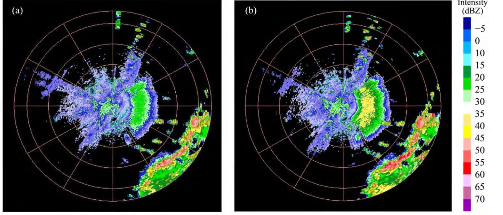
Figure 3 The radar images before typhoon Haitang landing.Images at the elevations of 0.48°(a)and 0.31°(b)at 230 km
4.2 Comparative analysis of the radar product for the Changmi typhoon with negative elevation angle detection
After the Changmi typhoon was generated on September 27,2008,the spiral cloud system in the peripheral typhoon began to enter the detecting area of the Changle radar on September 27 in the early evening.A comparative analysis on the detecting data with a negative elevation angle was conducted by the application of software of the WSR-98D radar product.
Figure 4a was the 19thproduct of the Changmi typhoon with the elevation angle of 0.49° at 07:52 on September 28,and figure 4b was that with the elevation angle of 0.36° at 08:05.Each range loop was 50 km within 200 km on the radar echo chart.A region in figure 4b was the cloud system echo of the typhoon and the B region was the sea wave echo compared with the basic reflective index on the 19thproduct of the two-volume scan.More echoes appeared in A and B regions with the negative elevation angle detection.The data produced after decreasing the elevation angle in figure 4b were more accurate and clear than original observational data.For example,the radar depictions of the sea wave echo and whole wind storm loop in the peripheral typhoon were more concrete in the product.The time that the warning of severe precipitation was sent out could advance with the period of two or three volume scans compared with the detection of the elevation angle of 0.49°.Of course,the increase of sea wave echo in the B region was not a result that was hoped for.
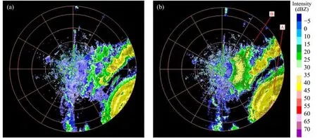
Figure 4 The radar images before typhoon Changmi landing.Images at the elevations of 0.49°(a)and 0.36°(b)at 230 km
Figure 5a was the 38thproduct of the Changmi typhoon with the detection at an elevation angle of 0.49°,at 07:52 on September 28,and figure 5b was the product with the detection at an elevation angle of 0.36° at 08:05.Each range loop was 100 km within 400 km on the radar echo chart.Compared with the radar combination reflective index of the 38thproduct for a different elevation angle,the detection with the negative elevation angle had a greater and wider typhoon echo than conventional elevation angle of 0.49°,and there were more strong echo areas of over 35 dBZ.Table 3 gave the calculated results with PPI data from the radar for the Changmi typhoon.The effective typhoon echo beyond 100 km with the detection with the elevation angle of 0.36° was about 1.09 times that of the elevation angle of 0.5° from the echo areas of detection,and it resulted in more about 2,282 range bins.Concerning the distribution of the strong echo,the echo from the detection with the elevation angle of 0.36° was clearly more than that of the elevation angle of 0.5° for echoes of 10–35 dBZ.There were clear advantages for the detection with the elevation angle of 0.36°.Table 3 quantitatively describes the two PPI data from above,and the distribution condition of the total amount of echo as well as the echoes of different intensities.The data in table 3 presented the number of range bins of radar scanning for the different echo intensities.
The echo from the detection with the elevation angle of 0.36° was noticeably more than that of the elevation angle of 0.5° for 10–35 dBZ echoes,in view of all the echo data.The detection with the elevation angle of 0.36° for the precipitation echo had stronger capacity for remote echo by comparative detection at different angles for the typhoon.The detection was affected by sea wave clutter in the closer distance compared with the elevation angle of 0.49°.The analyzed results were similar to those of the Haitang typhoon.
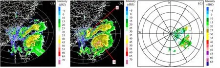
Figure 5 The radar images before typhoon Changmi landing.Images at the elevations of 0.49°(a)and 0.36°(b),and the difference of them(c)at 460 km
5 Sea wave clutter possibly interfered with the conclusion for the typhoon structure
The case analysis for the Haitang and Changmi typhoons may reveal that the negative elevation angle could improve the detecting capability of typhoons at the low level,even though,at the same time,it was affected by sea waves and ground objects.Figure 6 displayed the chart of the Rusa typhoon from the Hong Kong astronomical observatory.A loop of ring echoes appeared directly east of the radar from 50 km to 100 km at 10:00 on August 22,2008,and it seemed to be like the eye wall of the eastern part of Rusa,according to the red loop of figure 6a.However,the loop appeared again in the form of clutter at 00:00 on August 23.Clearly,it was not the echo of eye wall on the velocity diagram.Therefore,it was a type of false typhoon eye wall formed by sea wave clutter,according to the red loop in figure 6b,instead of the eye wall of the Rusa typhoon in the radar intensity diagram at 10:00.The real eye of the typhoon lied to the southeast of the red loop in figure 6b.Therefore,if the scanning strategy of the negative elevation angle were used,the sea wave clutter would have a greater influence on the results.This could easily cause the misjudgments and should be paid close attention to,with the results discriminated cautiously.Generally,this could be obviously seen in velocity diagram.It is possible to carefully discriminate the sea wave clutter from the actual radar results because there is a certain law guiding the appearance of sea echoes.Ordinarily,sea echoes appear closer to the radar center.
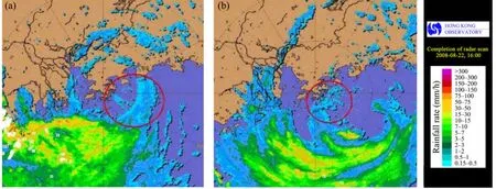
Figure 6 The image of typhoon Nuri false eye wall
6 Conclusion
The difference of the PPI echo data between the negative elevation angle and the lowest elevation angle of 0.5° for the Haitang and Changmi typhoons was analyzed by comparison,based on the echo data with the detection with the negative elevation angle in the Changle radar station.The conclusion of preliminary analysis was the following.
1)It was feasible to reasonably select the detection with the negative elevation angle under the condition of no or less influence of ground objects,according to the theory,analysis,and actual data.The effect of the detection with the negative elevation angle was better than that of the elevation angle of 0.5° for the detection of low level precipitation echoes,especially because it recognizably improved the remote detecting capability.The detection with the negative elevation angle had clear advantages on detecting capability beyond 100 km.There was little value for improving the radar scanning mode and further understanding the developing mechanism for the typhoon.
2)The distribution of the typhoon cloud mass which was reflected from the negative elevation angle of radar was clear,and the structure of typhoon could be comprehended entirely and precisely.The low level distribution of the precipitation cloud system could also be analyzed by the negative elevation angle.Using the negative elevation angle improved,to some extent,the detection and warning for low level typhoons.
3)After decreasing by 0.12° for the negative elevation angle,from the actual observation of the Haitang and Changmi typhoons,the warning time for typhoon could advance by 2 to 6 volume scan periods and the detecting range for the Changmi typhoon could increase by 1.09 times.The contrasting conditions of several other volume scans for the Haitang typhoon also reflected that the detecting range increased by about 2.1% to 9.6% with the elevation angle of 0.31°,compared with the elevation angle of 0.48°.Increasing the detection with the negative elevation angle was helpful for predicting the intensity and the development of the windstorm and for improving the effect of short-term warning.
4)While the low level structure of typhoon detection was improved by the negative elevation angle,it was easily affected by close sea wave clutter.Sometimes,the sea wave clutter could be possibly interfere with the judgment of the typhoon’s structure.
This research was funded by the Emphasis Opening Laboratory of Atmospheric Sounding,China Meteorological Administration and the State Key Laboratory of Disaster Weather,Chinese Academy of Meteorological Science(2007Y004).The data and the pictures were provided by Changle Radar Station of Fujian Province,Hong Kong Astronomical Observatory and Shanghai Institute of Typhoon.Thanks for Mr.RuiSheng Ge for carefully completing this paper.
Brown RA,Janish JM,Wood VT,2000b.Impact of WSR-88D scanning strategies on severe storm algorithms.Weather Forecasting,15:90–102.DOI:http://dx.doi.org/10.1175/1520-0434(2000)015<0090:IOWSSO>2.0.CO;2.
Brown RA,Wood VT,Barker TW,2002c.Improved detection using negative elevation angles for mountaintop WSR-88Ds:Simulation of KMSX near Missoula,Montana.Weather Forecasting,17:223–237.DOI:http://dx.doi.org/10.1175/1520-0434(2002)017<0223:IDUNEA>2.0.CO;2.
Brown RA,Wood VT,Sirmans D,2000a.Improved WSR-88D scanning strategies for convective storms.Weather Forecasting,15:208–220.DOI:http://dx.doi.org/10.1175/1520-0434(2000)015<0208:IWSSFC>2.0.CO;2.
Chen LS,1993.An Overview on Tropical Disasters Preliminary on SPECTRUM-90,Tropical Cyclone Disasters.Proceedings of ICSU/WMO International Symposium,12–16 Oct.,1992.China University Press,Beijing,pp.31–44.
Chen LS,Luo ZX,Li Y,2004.Advance research of landing tropical cyclone.Chinese Journal of Meteorology,(5):541–549.
Fan YY,1996.A Summary about the Field-based Scientific and the Operational Experiments for Typhoon,the Scientific and the Operational Experiment of Typhoon and the Theory Research of Weather Dynamics(No.1).1st edition.Meteorological Press,Beijing,pp.1–4.
Feng JM,Liu LP,Wang ZJ,et al.,2001.The comparison for observing cloud between Doppler Radar in earth’s surface and TRMM Satellite-borne Radar in Tibetan Plateau.Plateau Meteorology,20(4):345–353.
Fu YF,Li HT,Zi Y,2007.A case analysis on the cloud structure of precipitation in the valley of Tibetan Plateau for the detection of TRMM satellite.Plateau Meteorology,26(1):98–106.
Guo RF,Lu YB,Li Y,et al.,2005.The process analysis of rainstorm for typhoon Imbudo influencing Yunnan province.Plateau Meteorology,24(5):784–791.
Huang XY,Hu WD,Sun H,et al.,2009.A contrastive analysis of Doppler radar echo characteristics for causing extraordinary storm in the southeast of Hunan affected by Bilis typhoon and Sepat typhoon.Plateau Meteorology,28(3):626–633.
Wei YZ,Tang DZ,Xu JM,et al.,2007.Asymmetrical structure of wind field for typhoon aered with the detection of Doppler radar.Chinese Journal of Applied Meteorology,18(3):285–294.
Wei YZ,Wu CF,Lin CC,et al.,2008.The echo characteristics of Doppler Radar while cold air invading Typhoon Chanchu.Chinese Journal of Tropical Meteorology,24(6):500–508.
Wetzel M,Meyers M,Borys R,et al.,2004:Mesoscale snowfall prediction and verification in mountainous terrain.Weather and Forecasting,19:806–828.DOI:http://dx.doi.org/10.1175/1520-0434(2004)019<0806:MSPAVI>2.0.CO;2.
Xu ML,Duan X,Zhang XN,2006.A numerical simulation research on the developing characteristics of landing storm of Bay of Bengal.Plateau Meteorology,25(6):1139–1146.
Xu YL,Jiao MY,Bi BG,et al.,2006.An applied research on radar positioning method for coastal typhoon.Atmospheric Science,30(6):1119–1128.
Xu BL,Liu LP,Xu WJ,et al.,2008.An analysis on the detecting ability of low level echo with ultra-low elevation angle improving mountain radar.Meteorology,34(9):28–33.
Xu BL,Liu LP,Wang GL,2011.A precipitation estimation with ultra-low elevation angle improving mountain radar.Plateau Meteorology,30(5):1337–1345.
Zhang HX,Cui XP,Kang FQ,et al.,2007.The observational analysis of rainstorm process affected by a landing typhoon in Handan area.Plateau Meteorology,26(5):980–991.
Zhao F,Ji CX,Ren HX,et al.,2008.Technological research on nowcasting of making off-shore typhoon by applying Doppler Radar.Meteorology,34(5):64–73.
Zheng AA,Zhu HF,Fang X,et al.,2009.The feature analysis and warning research on supercell storm of severe tornado.Plateau Meteorology,28(3):617–625.
Zheng F,Zhong JF,Lou WP,2010.The feature analysis of severe tornado in Wenzhou Sepat typhoon.Plateau Meteorology,29(2):506–513.
Zheng LX,Zhang S,2006.An application on the prediction of falling area of rainstorm for typhoon Chanchu with radar product.The second annual conference of scientific paper between radar meteorology and the committee of meteorological radar with the Chinese Meteorological Society.
Zhu LB,Zheng Z,He CF,2005.The detection of Doppler Radar for typhoon Rananim of number 0412.Journal of Applied Meteorology,16(04):500–508.
 Sciences in Cold and Arid Regions2014年6期
- Sciences in Cold and Arid Regions的其它文章
- The effects of the identity of shrub species on the distribution and diversity of ground arthropods in a sandy desert ecosystem of northwestern China
- An analysis on ecological civilization construction in Gansu based on a quantified SWOT framework
- The effects of the identity of shrub species on the distribution and diversity of ground arthropods in a sandy desert ecosystem of northwestern China
- An estimation of groundwater storage variations from GRACE gravity satellites in the Heihe River Basin, northwestern China
- Study on dynamic changes of land desertification in the circum-lake zone of the Qinghai Lake in the past 30 years supported by Remote Sensing and Geographical Information System
- Impacts of reduced wind speed on physiology and ecosystem carbon flux of a semi-arid steppe ecosystem