
Ocean Observation from Haiyang Satellites
2020-04-16 13:56:56LINMingsenJIANGXingwei
空間科學(xué)學(xué)報 2020年5期
LIN Mingsen JIANG Xingwei
Ocean Observation from Haiyang Satellites
LIN Mingsen JIANG Xingwei
(100081)
In 2018, China successfully launched three new Haiyang (which means ocean in Chinese, referred to as HY) satellites which are an ocean color observation satellite HY-1C (operational), an ocean dynamics environment satellite HY-2B (operational) and the China-France ocean satellite CFOSAT (experimental). In 2019, all the three satellites had finished their commissioning phases and were declared operational. HY-2A satellite continues to operate in-orbit, and its operational status is basically normal. So in 2020, China has 4 Haiyang satellites in-orbit, China’s ocean satellites enter into a new operational application phase. The operation of the ground application system of Chinese ocean satellites is stable. In 2019, Beijing, Hainan, Mudanjiang, and Hangzhou ocean satellite ground stations had received the data of HY-1C, HY-2A, HY-2B, and CFOSAT 5012 orbits and 26.46 TB data had been distributed to both domestic and international users. Chinese ocean satellite data has played an important role in marine disaster prevention and mitigation, development and management of marine resources, maintenance of marine rights and interests, marine environment protection, scientific researches, and blue economy development.
HY-1C, HY-2B, CFOSAT, Ocean observation satellite, Ocean remote sensing, Satellite ocean applications
1 Development of Haiyang Satellites
In 2018, China successfully launched three new Haiyang (which means ocean in Chinese, referred to as HY) satellites which are the ocean color observation satellite HY-1C (operational), the ocean dynamics environment satellite HY-2B (operational) and the China-France ocean satellite CFOSAT (experimental). In 2019, all the three satellites finished their in-orbit tests, respectively. The test results show that the three satellites satisfy the design requirements. Then they were officially delivered to the Ministry of Natural Resources of People’s Republic of China (MNR) for the operational usage. All relevant Research and Development (R&D) tasks of HY-1D and HY-2C are almost done. The two operational satellites are planned to be launched in 2020. The missions of the other three operational satellites,, HY-2D and the two 1-meter C-SAR satellites, progress as expected. In terms of the experimental satellites, the R&D of the new generation ocean color satellite goes well, and the project of the ocean salinity observation satellite is under approval. They are planned to be launched during 2021 and 2022. The high orbit ocean and coastal zone environment monitoring satellite, the next generation ocean dynamics satellite and the geostationary microwave satellite are in the preliminary study phase.
HY-2A, the first ocean dynamic environment satellite of China, has been operated normally in-orbit for more than 8 years. Its operation status is basically stable, and its ground segment including receiving, processing, archiving, distribution and application systems works well, too. The ground segments of the other Chinese ocean satellites are designed and will be constructed as a whole mission including two phases according to the 12th National Five-Year Plan and 13th National Five-Year Plan of China. The first phase of the Chinese ocean satellite ground segment construction is to serve five satellites which are HY-1C, HY-1D, HY-2B, HY-2C, and CFOSAT. In 2019, the first phase of construction was almost done. The second phase construction is to serve the other 9 Chinese ocean satellites including 7 operational satellites and 2 experimental satellites. Some tasks of the second phase construction have already started in 2019 such as the data processing system of the two 1-meter C-SAR satellites. The calibration and authenticity inspection system of all Chinese ocean satellites is designed as an independent mission which has already been approved by the state.
In 2019, ocean applications of satellite data had been further improved. The operational monitoring of SST, sea ice, green tide, and typhoon are applied to ocean fishery, polar navigation support, marine environment and ecology protection, marine disaster mitigation, and island management. All the applications are carried out with not only Chinese ocean satellite data but also other domestic and international satellite data. In 2019, National Satellite Ocean Application Service (NSOAS) produced the daily, weekly, monthly and annual mean sea surface temperature fusion products of China’s adjacent sea areas and global oceans, respectively; issued 90 reports of sea ice monitoring, 129 reports of green tide monitoring and 121 reports of red tide monitoring of Chinese seas. NSOAS monitored 27 typhoons in 2019 and 384 thematic maps of typhoon remote sensing monitoring in the northwest Pacific region were produced and released. 407 reports of near real-time sea state analysis and fishery forecast information were issued to the ocean fishery enterprises. Satellite remote sensing images and thematic products were provided for the navigation support of China’s 36th Antarctic Scientific Expedition. The monitoring of suspicious illegal sea reclamation areas was carried out every 15 days. In general, the ocean application of satellite data had been further strengthened and expanded. It has played an important role in China’s marine disaster mitigation, comprehensive manage-ment of sea areas, marine environment and ecology protection, marine resource development, marine scientific research, regional marine applications, and international cooperations.
2 Data Acquisition and Distribution
National Satellite Ocean Application Service (NSOAS), which is a commonweal organization of MNR, is responsible for receiving, processing, archiving, managing, and distributing all collected products of Haiyang satellites. NSOAS owns four ground stations which are located at Beijing, Mudanjiang, Sanya, and Hangzhou respectively.
The operation of the Haiyang satellite ground system is stable. In 2019, it received the data of Chinese ocean series satellites (HY-1C, HY-2A, HY-2B, and CFOSAT) 5012 orbits and distributed 26.46 TB data to the domestic and international users.
2.1 Main Products
2.1.1? Ocean Color and Sea Surface Temperature
In 2019, based on the data of HY-1C, NSOAS opera-tionally produced marine color products of China’s adjacent sea areas, such as the averaged chlorophyll-a concentration products of ten days, every month, quarter, and the whole year (Figure1). NSOAS also produced global land normalized difference vegetation index and ocean chlorophyll-a concentration product monthly and annually (Figure2). All the aforementioned products were provided to relevant uses of marine environment monitoring, marine fishery, and so on. The users commented that the products had become an important information source to support their operational works.
In 2019, the sea surface temperature fusion products with a spatial resolution of 5 km were made daily, weekly, monthly, quarterly, and annually for China’s adjacent sea areas and global oceans based on the data of HY-2A, HY-2B, and HY-1C. Sea surface temperature fusion products have played an important role in both sea surface temperature prediction and marine fishery environment monitoring.
2.1.2 Ocean Reanalysis Products
Based on HY-2 satellites, POMgcs and MITgcm ocean models, the Northwest Pacific Ocean and global ocean reanalysis products were developed with the sea surface temperature data of radiometers, sea surface height data of altimeters and wind field data of scatterometers, combining the 0.25° resolution OISST sea surface temperature data and the 0.125° resolution CLS sea surface height data provided by NOAA and other foreign fusion data (Figure3). The multi-grid three-dimensional variation method is used to assimilate the on-site temperature and salt observations, satellite remote sensing sea surface tem-perature, and sea surface height data. The Northwest Pacific Ocean and global ocean reanalysis products are released through the national marine science data sharing service platform. The accuracy of the mode field is effectively improved.
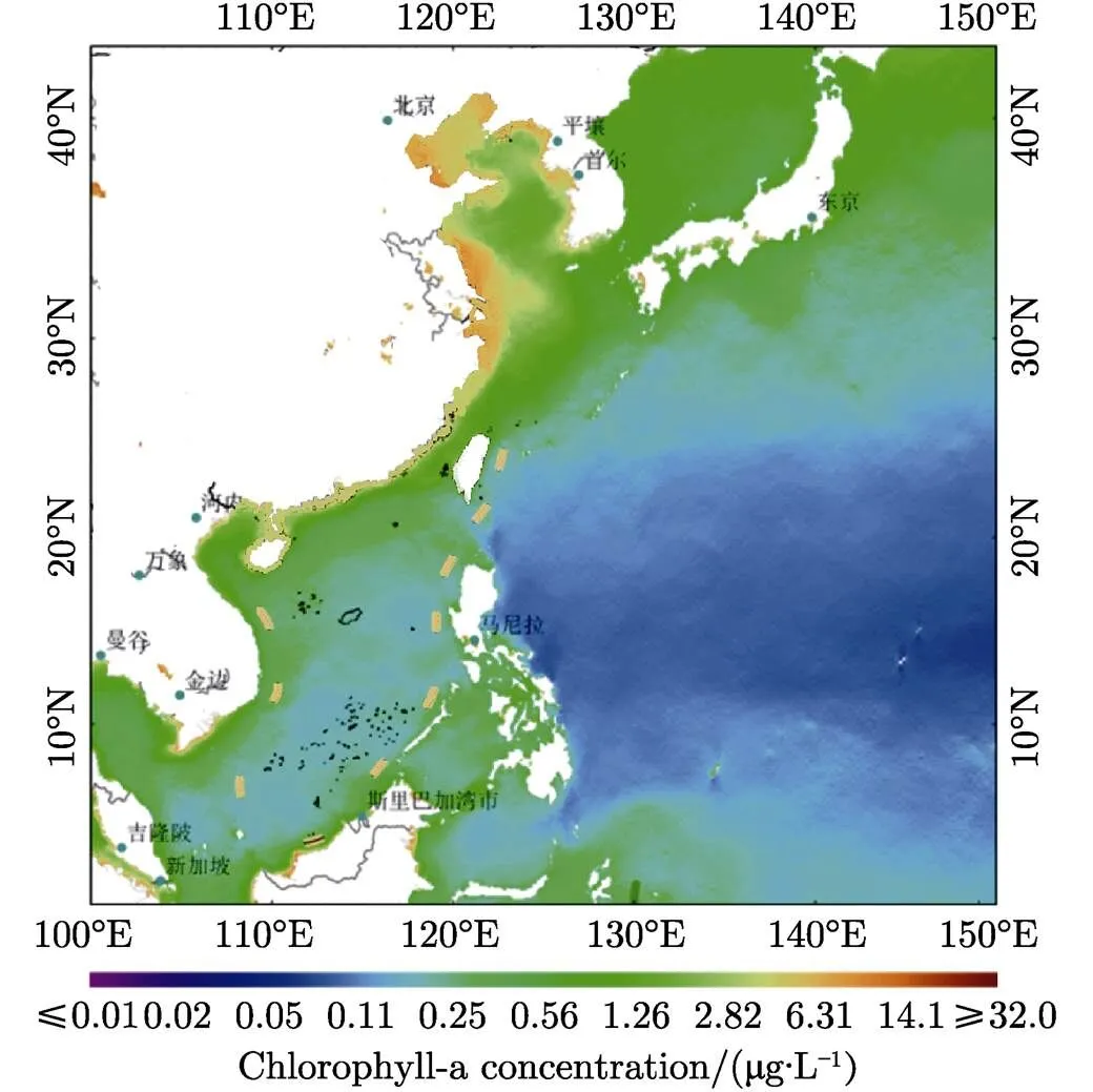
Fig.1 Averaged chlorophyll-a concentration product of China’s adjacent sea areas in 2019 (? NSOAS/MNR, 2019 - All Rights Reserved)
2.1.3 Ocean Three-dimensional Products
Based on the independently developed Northwest Pacific real-time analysis system, the three-dimensional real-time analysis products of temperature, salt, density, and sound velocity for the Northwest Pacific ocean were produced in 2019 (Figure4). The data of daily remote sensing sea surface temperature and sea surface height are fused. The products provide the initial field conditions for the ocean numerical models and the underwater dynamic environment data for the real-time support of the marine environment.
2.1.4 Ocean Surface Laminar Flow Fusion Products
Based on the data of sea surface dynamic height and scatterometer wind field, the inversion of geostrophic current and Ekman current is calculated, and the comprehensive flow field of sea surface is constructed by integrating sea surface current. On this basis, the multi-scale surface current assimilation model is used to assimilate the observation data of the surface current field, such as ground wave radar, so as to form the integrated surface current products.

Fig.2 Global averaged land normalized difference vegetation index and ocean chlorophyll-a concentration product of 2019 (? NSOAS/MNR, 2019 - All Rights Reserved)

Fig.3 Northwest Pacific sea surface temperature (a) and sea surface height (b) reanalysis products on 1 December 2017

Fig.4 Products of temperature, salinity, density and sound velocity for the Northwest Pacific Ocean (taking 500 m depth as an example) on 18 December 2019
2.2 Product Distribution
In 2019, through Chinese ocean satellite application services, 49611 GB of HY-1C satellite data, 14123GB of HY-2A satellite data, 6546GB of HY-2B satellite data and 3509GB of CFOSAT data were distributed to 275 users from 131 organizations, institutes, universities,. 230622 scenes and 304.16 TB data of Gaofen (which means high resolution in Chinese, referred to as GF) satellites were distributed to 72 departments, including 3156 scenes and 1.27 TB data of GF-1, 5456 scenes and 1.93 TB data of GF-2, 211370 scenes and 299.00 TB data of GF-3, 10640 scenes and 1.96 TB data of GF-4.
3 Application Achievements
3.1 Ocean Disaster Surveillance
3.1.1 Spilled Oil Monitoring
In 2019, oil spill remote sensing monitoring was carried out over Bohai Sea, the East China Sea and the South China Sea mainly using the satellite data of GF-3 and Radarsat-2. Particularly for the oil spill incident of the sea area near Sanya, Hainan Province, the GF-3 SAR data, HY-1C CZI, UVI data, and other sensors data were used to implement the oil spill monitoring. The products provided important information to support decision makings of rapid response, emergency treatment, marine ecological environment protection, and restoration caused by the oil spill incident (Figure5).
3.1.2 Ice Monitoring
In 2019, the operational monitoring of winter sea ice in the Bohai Sea and the northern Yellow Sea was carried out as usually with the data of HY-1C, Gaofen satellite, EOS/MODIS, Radarsat-2, and other satellites. It realized one ice period per day and 90 ice periods in total. The products were distributed to sea area management departments, provincial and municipal departments providing indispensable information support for sea ice monitoring, disaster assessment and emergency response (Figure6).
3.1.3 ??Green Tide Monitoring
In 2019, the operational monitoring of green tide in China’s offshore sea areas was carried out normally particularly for the joint prevention and control of green tide in the Yellow Sea cross region (Figure7). GF-1, GF-2, GF-3, GF-4, EOS/MODIS, and other satellite data were used. 129 reports of green tide satellite remote sensing monitoring were issued. The early detection of green tide disaster and the whole process tracking monitoring were realized which made the path prediction of green tide drift possible. The products provided accurate and timely information services for disaster prevention and mitigation.
3.1.4 Red Tide Monitoring
In 2019, the red tide monitoring was carried out in the North Sea and South China Sea with the data of GF-4, EOS/MODIS, and NOAA/AVHRR. Seven red tide satellite remote sensing monitoring information express reports of Liaodong bay, and 46 red tide satellite remote sensing monitoring information express reports of Beidaihe and its adjacent waters were produced. Twelve monthly reports and 52 weekly reports of red tide remote sensing monitoring in the South China Sea were produced and an emergency phase 4 alert was issued. All the products are provided to relevant departments of coastal provinces and cities through leased lines, E-mail,.
3.1.5 Tropical Cyclones Monitoring
In 2019, using microwave scatterometer data such as HY-2A, HY-2B, CFOSAT and METOP-A/B satellites, NSOAS carried out typhoon monitoring in the Northwest Pacific Ocean area. A total of 27 typhoon processes were monitored throughout the year, and 384 thematic maps of typhoon remote sensing monitoring were made, which were timely provided to the marine forecasting departments at the national, regi--onal and provincial levels for consultation of Typhoon Forecasting in flood season. It provides near real-time information supporting typhoon treatments.
3.2 Costal Zone and Sea Management
3.2.1 Suspicious Illegal Sea Reclamation Monitoring
In 2019, with the data of GF-1A/B/C/D, GF-2, GF-3, GF-6, Resource-3/01~02, and Resource-1/02C, suspicious illegal sea reclamation area monitoring was carried out to entire China’s coastal zone areas every 15 days. The operational products and reports provided efficient and powerful information support for the state to strictly manage the reclamation.

Fig.5 Sanya oil spill monitoring products respectively derived with GF-3 and HY-1C data (8–9 April 2019)

Fig.6 Sea ice situation image of Bohai Sea derived by HY-1C satellite (9 January 2019)
3.2.2 Continuously Monitoring of Reclamation Projects
The reclamation projects approved by national and local governments were quarterly monitored with high-resolution time-series satellite images. Combining with the on-site survey data, the reclamation beyond the approved scope was identified. The products were operationally distributed to relevant government departments for the supervision usage.
3.2.3 Ecological Red Line Verification
In 2019, with the data of GF-1 and GF-2 satellites, Beihai Bureau of MNR verified human development activities according to the marine ecological protection red line. Remote sensing images were interpreted and analyzed to detect the human development activities in the red line protection areas (Figure8). The detected areas were continuously monitored; the dynamic changes of human development and utilization activities in the red line protection areas were issued to relevant government departments for the supervision and management of the marine ecological protection red line.

Fig.7 Thematic map of green tide monitoring in Yellow Sea with the data of HY-1C (6 July 2019)
3.2.4 Mariculture Area Monitoring
In 2019, the mariculture area monitoring was carried out with the data of GF-1, GF-2, GF-3, GF-6, and other satellites. For Rongcheng city of Shandong province, Lianyungang city of Jiangsu province and Ningde city of Fujian province, monthly monitoring was carried out to derive the dynamic changes of mariculture areas. A floating raft mariculture area thematic map of Changhai county, Dalian city, Liaoning province is presented as follows (Figure9). This kind of product is provided to continuously monitor sea areas and to support island management for Liaoning province. The monitoring report has become an important basic map for sea area management of Liaoning province.
3.3 Ocean and Polar Applications
3.3.1? Ocean Fisheries Services
In 2019, based on the data of HY-2A, HY-2B, and HY-1C satellites, combined with the GF satellite data, the weekly operational analysis, and forecast of fishery situation in 10 sea areas of the three oceans all over the world were carried out. 407 reports of near real-time sea situation analysis and forecast information were issued to the national ocean fishery enterprises. The reports were helpful to the scientific ocean fishery management of China to gain significant economic benefits (Figure10).

Fig.8 Detected human development activities in the restricted development zone
Fig.9 Mariculture area monitoring product of Changhai county, Dalian city, Liaoning province

Fig.10 Prediction results of sea surface temperature and fishing situation of Trachurus murphyi fishing grounds in the Southeast Pacific on 11 February 2019
3.3.2 ?Polar Navigation Safeguard
In 2019, the ship-borne mobile receiving and data pro--cessing system on the Xuelong (which means snow dragon) ship provided satellite remote sensing images and thematic products for the navigation safeguard of China’s 36th Antarctic Scientific Expedition. With the data of HY-1C and GF-3, the floating ice dynamic change monitoring products were provided for the icebreaker navigation to guarantee it travels safely and rapidly in the floating ice areas. To gua-rantee the unloading procedure of Zhongshan station, HY-1C, GF-3, and other satellites had continuously monitored the fixed ice around Zhongshan station. Key information such as ice disorder areas, ice crack distributions, and selected suitable landing points for Xuelong ship had obtained to help the investigation team to reasonably plan the ice transportation routes of snowmobiles. With the guarantee of the products, the sea ice unloading of Zhongshan Station was completed safely and smoothly (Figure11, 12).
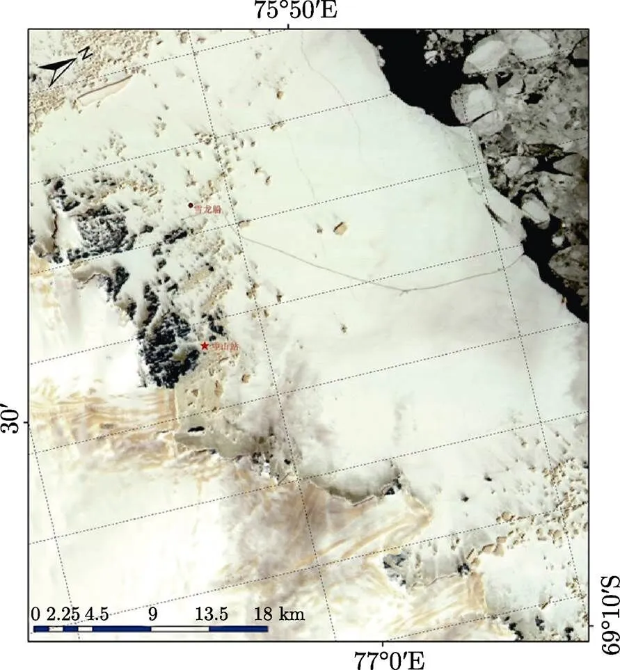
Fig.11 50 m resolution image of the ice area near Zhongshan Station derived by HY-1C satellite on 24 November 2019

Fig.12 10-meter resolution image of fixed ice areas around Zhongshan Station derived by GF-3 satellite on 27 November 2019
3.4 Marine Ecology Protection and Restoration
3.4.1 Coastal Wetland Investigation
In 2019, based on the 16-meter resolution satellite remote sensing images of GF-1, a coastal wetland inventory investigation was carried out around the North Sea, focusing on the information of wetland type, distribution, and area elements. Based on the satellite remote sensing images of GF-2, a refined monitoring was carried out in the typical ecological monitoring areas of the Yellow River Estuary and Jiaozhou Bay. The wetland resources and ecological changes in these typical ecological monitoring areas were completely derived and had supported the coastal wetland ecological protection.
3.4.2 Invasive Plant Alterniflora in the Coastal Zone
Based on the data of GF-1 satellite derived in 2019, the remote sensing investigation of the invasive plant Spartina alterniflora in Shandong coastal zone was carried out, and the invasion status of Spartina alterniflora in different regions was analyzed. The thematic map of the spatial distribution of Spartina alterniflora in Shandong coastal zone was made. It provided important information support to the control and management of Spartina alterniflora in Shandong Province.
3.4.3 Biomass Distribution of Typical Vegetation
Based on the WFV sensor data derived by GF-1 in September 2019 and the on-site survey data, the typical vegetation biomass estimation of Jiaozhou Bay coastal wetland was carried out. The thematic map of typical vegetation biomass distribution of Jiaozhou Bay coastal wetland was made (Figure13). It provided basic information support for the marine and coastal zone management departments of Qingdao city to formulate the protection and management policies of Jiaozhou Bay coastal wetland.
3.4.4 Mangrove Ecosystem in China
Based on the GF-1 data of 2019, the national mangrove spatial distribution information extraction was carried out, and the thematic map of mangrove spatial distribution in China was made. In 2019, the national mangrove area is about 216.1 km2. The results provided basic information support for mangrove management and protection in China.

Fig.13 Thematic map of biomass spatial distribution of Spartina alterniflora around Jiaozhou Bay
3.4.5 Coral Reef Ecosystem Investigation
With the GF-1/GF-2 satellite remote sensing data obtained from 2016 to 2018, an investigation of the distribution of coral reef geomorphic units in Xisha Islands was carried out for reef building and reef cov-erage usages. The first thematic map of coral coverage of Xisha Islands was made, which provided basic information support for the management of coral islands and reefs in the South China Sea of Sansha city.
4 Future Plans
Seven Chinese ocean satellites have been successfully launched. In 2020, five of them operate normally in-orbit (including GF-3). Five operational Haiyang satellites are under development. Two experimental Haiyang satellites will be approved soon. More than three other new Haiyang satellites are under preliminary study.
Chinese ocean satellites have achieved the parallel operations of three series Haiyang satellites which carry optical sensors, microwave sensors, and synthetic aperture radars, respectively. Haiyang satellites take the wide swath advantage of medium and low resolution remote sensing techniques to repeatedly observe the global oceans with high time- resolution. The data of Haiyang satellites have been widely used in marine disaster mitigation, marine environment, and ecology protection, marine resource development, coastal zone and island mana-gement, etc. Their products have become an indispensable information source for the comprehensive management of the seas and oceans.
Acknowledgements Thanks for the technical coo-perations provided by Centre National d’Etudes Spatiales, France (CNES) on the precise orbit deter-mination, and the radar altimeter data processing of HY-2. Thanks to EUMESAT, the exchanged European Centre for Medium-Range Weather Forecasts (ECMWF) data have provided significant helps to the data processing and the measurement error correction of HY satellite sensors. Thanks for the cooperationof Royal Netherlands Meteorological Institute (KNMI) for the data processing and the performance evaluation of scatterometers.
[1] Ministry of Natural Resources of the People’s Republic of China. Chinese Ocean Development Report in 2019 [R]. Beijing: Ministry of Natural Resources of the People’s Republic of China, 2019
[2] Ministry of Natural Resources of the People’s Republic of China. Chinese Ocean satellite Application Report in 2018 [R]. Beijing: Ministry of Natural Resources of the People’s Republic of China, 2019
[3] Ministry of Natural Resources of the People’s Republic of China. Chinese Ocean satellite Application Report in 2019 [R]. Beijing: Ministry of Natural Resources of the People’s Republic of China, 2020
[4] Lin Mingsen, HE Xianqiang, JIA Yongjun,. Advances in marine satellite remote sensing technology in China [J]., 2019, 41(10):99-112
[5] JIANG Xingwei, HE Xianqiang, LIN Mingsen,. Progresses on ocean satellite remote sensing application in China [J]., 2019, 41(10):113-124
[6] Ministry of Natural Resources of the People’s Republic of China (MNR)& China Aerospace Science and Technology Corporation (CASC). General Requirements of HY-1C Satellite Engineering Research [R]. Beijing: MNR and CASC, 2010
[7] Ministry of Natural Resources of the People’s Republic of China (MNR)& China Aerospace Science and Technology Corporation (CASC). General Requirements of HY-1B Satellite Engineering Research [R]. Beijing: MNR and CASC, 2011
[8] Ministry of Natural Resources of the People’s Republic of China (MNR)& China Aerospace Science and Technology Cor-poration (CASC). General Requirements of CFOSAT Satellite Engineering Research [R]. Beijing: MNR and CASC, 2012
P 731
LIN Mingsen, JIANG Xingwei. Ocean Observation from Haiyang Satellites., 2020, 40(5): 898-907. DOI:10.11728/cjss2020.05.898
March 21, 2020
E-mail: mslin@mail.nsoas.org.cn
- 空間科學(xué)學(xué)報的其它文章
- Space Solar Physics in China*
- Space Materials Science in China: I. Experiment Studies under Microgravity*
- Space Life Science of China*
- Advances in the Researches of the Middle and Upper Atmosphere in China
- Magnetospheric Physics in China*
- Status of the Advanced Space-based Solar Observatory*