
Nonmarine time-stratigraphy in a rift setting: An example from the Mid-Permian lower Quanzijie low-order cycle, Bogda Mountains, NW China
2015-08-22 03:04:18JonathanObristFarnerWanYang
Journal of Palaeogeography 2015年1期
Jonathan Obrist-Farner , Wan Yang
1. Geology and Geophysics Program, Missouri University of Science and Technology, Rolla, Missouri 65409, USA
2. Key Laboratory of Petroleum Resources Research, Institute of Geology and Geophysics, Chinese Academy of Sciences,Beijing 100029, China
Abstract Sedimentological and stratigraphic studies of seven stratigraphic sections of Permian Hongyanchi (HYC) and Quanzijie (QZJ) low-order cycles (LCs) in the Tarlong-Taodonggou half graben and Dalongkou area in Bogda Mountains, NW China, demonstrate effective approaches and methodology in cyclo- and time-stratigraphic analyses of complex fluviallacustrine deposits in an intracontinental rift setting. A new synchronous stratigraphic unit, the lower QZJ LC is defined. The lower and upper boundaries of this cycle include a regionally correlative disconformity, erosional unconformity, and conformity, across which significant and abrupt changes in palaeoenvironments and tectonic and climatic conditions occurred. The lower boundary is an erosional unconformity and disconformity with a high-relief topography that juxtaposes lacustrine deposits of the underlying HYC LC with the overlying meandering stream deposits of the lower QZJ LC, and was caused by a regional tectonic uplift. The upper boundary is a disconformity and local erosional unconformity and conformity, juxtaposing stacked paleosols developed on fluvial sediments with overlying fluvial and loessial deposits of the upper QZJ LC. The paleosols indicate landscape stability and a prolonged period of subaerial exposure and minimal deposition and suggest that climatic conditions were semiarid with strong precipitation seasonality in the Tarlong-Taodonggou half graben and subhumid in the Dalongkou area. The fluvial-loessial deposits indicate a renewed tectonic uplift and a change in the atmospheric circulation pattern. The newly-defined lower QZJ LC facilitates accurate palaeogeographic reconstruction in the study area during a period of major tectonic and climatic changes. The interpreted tectonic and climatic conditions provide a critical data point in the mid-latitude east coast of NE Pangea during the Mid-Permian icehouse-hothouse transition. The results demonstrate that a process-response approach is effective in timestratigraphic analysis of complex fluvial-lacustrine strata in a highly-partitioned rift basin.
Key words fluvial, loess, cyclostratigraphy, Permian, China
1 Introduction*
Continental deposits are stratigraphically complex,including abundant erosional surfaces, rapid lateral and vertical facies and thickness changes, multiple sediment sources, and poor biostratigraphic resolution (Miall, 1996;Talbot and Allen, 1996; Olsen, 1997; Blum and T?rnqvist,2000; Lowensteinet al., 2003). This intrinsic complex-ity makes time-stratigraphic correlation difficult, which is needed for accurate palaeogeographic reconstructions. A time-stratigraphic approach to fluvial-dominated but ma?rine-influenced strata has been successfully applied (Shan?ley and McCabe, 1994), because the processes controlling the formation of correlative sedimentary packages and as?sociated surfaces can be related to shoreline shifts (Catu?neanu, 2006). However, the approach to intracontinental fluvial-lacustrine settings is not effective due to the inter?play of allogenic and autogenic controls on fluvial-lacus?trine sedimentation not associated with shifting shorelines(Shanley and McCabe, 1994; Catuneanu, 2006). Previous studies in nonmarine sequence stratigraphy have used var?ious evidences, for example, fluvial styles (Legarreta and Uliana, 1998), petrographic data (Miall and Arush, 2001)and paleosols (Bown and Kraus, 1987; Kraus and Brown,1988; Kraus, 1999) to subdivide valley fills into correla?tive sequences, but successful studies are limited.
This study focuses on the transitional interval between the Hongyanchi (HYC) and Quanzijie (QZJ) low?order cycles (LCs) in the Tarlong?Taodonggou half graben in the southern Bogda Mountains and the Dalongkou area in northern, NW China (Yanget al., 2010). We demon?strate complexities in fluvial valley fills and establish a time?stratigraphic correlation using a process?response approach combining multiple sedimentologic and strati?graphic proxies. A new regional time?stratigraphic surface is identified, resulting in the definition of a new timestratigraphic unit — the lower QZJ LC. This is achieved by high?resolution cyclostratigraphic correlation among six stratigraphic sections in a 60 km2study area. Other?wise, miscorrelation would be inevitable. The lower cycle boundary is mainly tectonic in origin, whereas the upper boundary is of a mixed climatic and tectonic origin. The palaeogeographic evolution of the study interval is clearly depicted. This study improves the understanding of basin?filling processes in half grabens.
2 Geological background
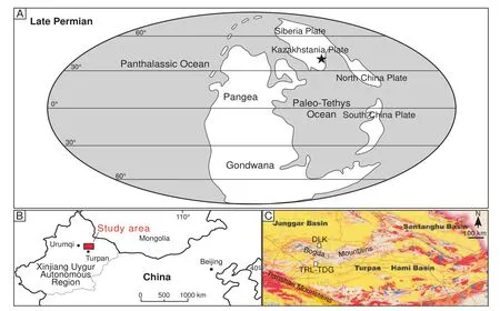
Figure 1 A-Global palaeogeographic reconstruction for the Late Permian. Modified from Scotese (2002). The location of the study area is marked with a black star; B-Location of the study area in the Xinjiang Uygur Autonomous Region, NW China; C-Geological map of eastern Xinjiang, showing locations of Tarlong-Taodonggou half graben (TRL-TDG) and Dalongkou area (DLK). Modified from Xinjiang Bureau of Geology and Mineral Resources (1993).
The Permian HYC and QZJ Formations are widely present in outcrop and the subsurface of the Turpan?Hami and the Junggar Basins, NW China (Figures 1, 2, 3). This study focuses on the Tarlong?Taodonggou half graben and Dalongkou area in the southern and northern foothills of the Bogda Mountains, respectively, in the southeastern Kazakhstania Plate, NE Pangea, between ~40° to 50° N paleo-latitude (Figure 1A; Allenet al., 1995; Carrollet al., 1995; Seng?r and Natal’in, 1996; Scotese, 2002; Yanget al., 2010). The basin has many grabens that formed by intracontinental rifting since the latest Carboniferous(Yang, 2008; Yanget al., 2013). The Tarlong-Taodonggou half graben was interpreted as a half graben on the basis of rapid lateral facies changes of uppermost Carboniferous to Lower Triassic deposits (Yanget al., 2010).
The HYC and QZJ LCs are informal cyclostratigraphic units defined on the basis of long-term trends of environmental, tectonic, and climatic conditions by Yanget al.(2007, 2010), and correlative largely to the HYC and QZJ Formations (Figure 3; Xinjiang Bureau of Geology and Mineral Resources, 1993, 1999; Zhuet al., 2005). The chronostratigraphy is poorly constrained by bio- and lithostratigraphy (Warteset al., 2002; Zhuet al., 2005; Metcalfeet al., 2009). Recent U-Pb zircon ages of isotope dilution thermal ionization mass spectrometric (IDTIMS)analyses ages from Yanget al.(2010) constrain the HYC LC to a Sakmarian-Artinskian age. They also placed the QZJ LCs as Capitanian and estimated that the hiatus represented by the HYC-QZJ unconformity may span up to~14 Ma. Finally, they interpreted the disconformity on top of stacked Calcisols in N Tarlong and Taodonggou and a channel base in SE Tarlong as the boundaries between the HYC and QZJ LCs. The N Tarlong and Taodonggou sections were described in detail in their study. With five additional sections, the present contribution rectifies a miscorrelation made by Yanget al.(2010), and establishes two new LCs, namely, the lower and upper QZJ LCs in the interval from the upper part of HYC and the lower part of the QZJ LCs of Yanget al.(2010).
3 Data and methodology
Seven stratigraphic sections from the upper part of the HYC LC to the lower part of the QZJ LC, both of which were defined previously by Yanget al.(2010), were measured at a cm-dm scale, including six sections in the Tarlong-Taodonggou half graben, and one in the Dalongkou area (Figure 2). Lithology, sedimentary structures and texture, fossil content, boundary relationships, and stratal geometry of individual rock units from each section are studied. The lateral thickness and lithological variations of the individual units are described and, in some cases,measured, across outcrops commonly 50-300 m wide.The data is used to define lithofacies; their characteristics,combined with thickness and lithologic stacking patterns and lateral variations, are used to interpret depositional environments.
Subsequently, sedimentary cycles are delineated using the criteria and methodology of Yanget al.(2010), who recognized three orders of cycles in the Tarlong-Taodonggou half graben. A high-order cycle (HC) is defined by repetitive changes of interpreted depositional environments commonly associated with lake expansion and contraction, or repetitive changes between erosion/nondeposition and deposition as the case of fluvial erosion and deposition (Yanget al., 2010). HCs are regarded as basic cyclostratigraphic entities and provide a framework to facilitate interpretations of processes and factors controlling erosion, nondeposition, deposition, and environmental changes. A LC is defined by a group of HCs showing similar environmental variations and formed under persistent tectonic and/or climatic conditions, and bounded by loworder cycle boundaries across which major tectonic and/or climatic changes and associated environmental shifts occurred. These boundaries should be correlative grabenwide or basin-wide. Yanget al.(2010) also defined intermediate-order cycles, where systematic stacking of HCs can be linked clearly with lake expansion and contraction.However, definition of intermediate-order cycles is not the focus of this study and is not carried out.
In addition, a total of 19 thin sections of sandstone,shale, mudstone, calcitic nodules, and limestone samples from the study interval are studied under a petrographic microscope. Grain composition, size, sorting, roundness,and contacts, matrix-to-grain ratio, and type of cement are documented. The information is used to supplement and substantiate field observations in lithofacies definition and environmental interpretation.
4 Lithofacies and depositional environments
Five lithofacies are identified in the study interval and are interpreted as fluvial, lacustrine, or eolian deposits.Their characteristics, stacking patterns, and interpreted depositional environments are essential to subsequent cyclostratigraphic analysis and interpretation of major autogenic and allogenic processes controlling sedimentation.
4.1 Lithofacies 1 — Clast-supported conglomerates
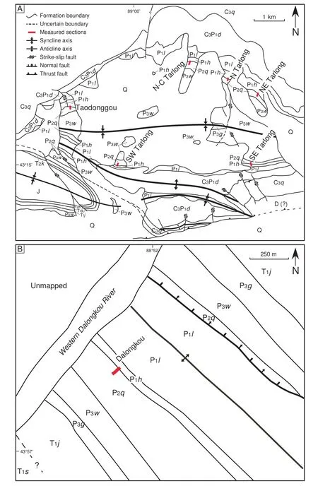
Figure 2 Geologic maps of Tarlong?Taodonggou half graben (A) and Dalongkou (B) area showing names and locations (red lines)of measured sections. A is modified from Yang et al. (2010). D = Devonian; C3q = Upper Carboniferous Qiergusitao Formation (Fm.);C3P1d = Upper Carboniferous-Lower Permian Daheyan Fm.; P1l = Lower Permian Lucaogou Fm.; P1h = Lower Permian HYC Fm.;P2q = Middle Permian QZJ Fm.; P3w = Upper Permian Wutonggou Fm.; P3g = Upper Permian Guodikeng Fm.; T1j = Lower Triassic Jiucaiyuan Fm.; T1s = Lower Triassic Shaofanggou Fm.; T2k = Middle Triassic Karamay Fm.; J = Jurassic; Q = Quaternary.
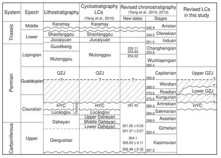
Figure 3 Litho?, cyclo?, and chronostratigraphy of the Upper Carboniferous-Middle Triassic strata in the Tarlong?Taodonggou half graben. The newly-defined lower QZJ LC is bounded by disconformities and erosional unconformities, but its age is poorly con?strained. Wavy lines = Major unconformities; dashed lines = Disconformity; hatched areas = Missing strata. Absolute ages at stage boundaries from Gradstein et al. (2005). Modified from Yang et al. (2010, 2013).
Clast-supported conglomerates are common in the study interval. Those in the Tarlong?Taodonggou half gra?ben are dominantly igneous, whereas those in Dalongkou are mainly sedimentary. The gravels range from cobble to granule, and are mainly pebble?sized. They are moderately to well sorted and angular to subrounded. A sandy matrix is common. The gravels are commonly imbricated or par?allel to the bedding plane. Large?scale tabular and trough cross bedding are common. The base of the conglomerates is erosional and concave upwards, whereas the top is com?monly flat and gradational.
Three types of conglomerates are differentiated on the basis of stratal geometry, sedimentary structures, and grain size trends. The first type is 2-5 m thick, has a clear finingupward grain size trend, a high?relief erosional base, and is laterally persistent for 100s of meters (Figure 4A). The second type is 0.5-2 m thick, does not have a clear finingupward trend but a low?relief erosional base, and is later?ally persistent for 10s of meters. The second type changes abruptly to the overlying mudrocks with minimal or no sandstones, and is encased in mudrocks (Figure 4B). The third type is rare, 0.2-0.5 m thick, has no clear grain size trend but a sharp base, and is laterally persistent for 100s of meters. It is well sorted and rounded, and commonly overlain by dark gray shales with a sharp to gradational contact.
The clast?supported fabric, erosional base, tabular and trough cross bedding, imbricated gravels, and overall fining-upward grain size trend indicate that the first two types of conglomerates are stream?channel deposits. The large thickness and high-relief erosional base of the first type underlie sandstones and mudrocks and is interpret?ed as channel?lag and point?bar deposits in meandering streams. In contrast, the thin and laterally?limited con?glomerates of the second type were likely deposited in small, poorly-defined stream channels, poor in sand and mud, and mostly commonly associated with ephemeral,gravelly braided streams (Miall, 1996). The third type of conglomerates is interpreted as lacustrine beach or litto?ral deposits on the basis of their sheet?like geometry and mature texture.
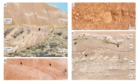
Figure 4 Field photographs showing features of some lithofacies. A-Western subsection in NE Tarlong showing a meandering stream channel cutting into underlying algal?laminated wackestone of HYC LC with a 5?m relief, forming an erosional unconformity(black dashed line) as the boundary between the HYC and lower QZJ LCs. The channel-fill conglomerate and sandstone change later?ally into thin overbank deposits to the right (west); both of which are capped by a thin white?gray calcrete of the upper Calcisol (arrow;see text). The upper part is reddish purple loessite encasing thin and narrow, gray conglomerate bodies with a sharp base as ephemeral?stream channel fills in basal upper QZJ LC. Yellow dashed line is the boundary between lower and upper QZJ LCs. View is ~100 m across. The photo is tilted to better illustrate the stratigraphic relationship. South is up. The upper QZJ slope dips to the north at ~45°.The strata dip to the south at ~60°; B-Basal upper QZJ LC showing small gray ephemeral-stream channel-fill conglomerate bodies with a sharp base (arrows) encased in reddish purple loessite. The beds are overturned; stratigraphic?up is to the lower left. Person is 1.9 m tall. Taodonggou section; C-A trench profile in basal upper QZJ LC, showing reddish purple to brown, blocky, massive loessite containing multi?faceted peds. The overall stratal dip is to the left, but no bedding is present in the loessite. Stratigraphic?up is to the left(north). SE Tarlong section; D-Two stacked Calcisols separated by a black dashed line in the eastern subsection of NE Tarlong, show?ing Bk horizons rich in light gray calcitic nodules and calcretes and Bt horizons rich in illuvial clay. Crude antiforms, synforms, and vertic features (arrows) can be discerned by geometry of calcretes and preferential alignment of nodules. The top of the upper calcrete is the boundary between lower and upper QZJ LCs. Hammer length = 24 cm.
4.2 Lithofacies 2 — Sandstones
Sandstones in the studied sections are lithic wackes to arenites. Framework grains range from very fine to very coarse sand, with floating granules and pebbles, and are subangular to rounded. Basaltic lithics dominate in the Tarlong?Taodonggou half graben, whereas sedimentary lithics dominate in the Dalongkou area. The sandstone lithofacies is subdivided into three subfacies on the ba?sis of their depositional environments that are interpreted based on their textural and structural characteristics, fos?sil content, stratal geometry of individual sandstone units,vertical and lateral variations in grain size and thickness,boundary relationships, and stacking patterns with adja?cent lithofacies.
Lithofacies2a—Fluvial sandstone subfacies
Three types of fluvial sandstones are distinguished. The first type has limited lateral extent and overlies ephemeralstream conglomerates. The sandstones are lithic subaren?ite to wackes, and contain medium to very coarse sands with common floating granules and pebbles. The grains are subangular to subrounded. Internal erosional surfac?es, plane beds, and trough and low?angle tabular cross beds are common. This type of sandstone is thin and occurs sporadically. The second type is thick lithic arenite to subarenite and occurs in fining-upward conglomeratesandstone-mudrock successions. Sand grains are medium to very coarse, subangular to subrounded, and moderately to poorly sorted. Internal erosional surfaces and trough and tabular cross beds are common. Accretionary surfaces are apparent in many cases. Finally, the third type consists of very fine to fine-grained lithic wackes, and commonly occurs as thin, lenticular beds in mudrock-rich intervals.
The first type of fluvial sandstones is interpreted as waning-flow sandy deposits associated with ephemeralstream conglomerates. The second type is interpreted as laterally-accreting point-bar deposits associated with underlying channel-lag conglomerate and overlying shale of an overbank origin (see below). The third type of sandstones is interpreted as deposits in a mud-rich meandering stream overbank environment.
Lithofacies2b—Lakeplain-littoral sandstone subfacies
This subfacies contains lithic arenite and subarenite.Sand grains are very fine to medium, with scattered floating granules, moderately well to very well sorted, and subangular to subrounded. Climbing ripple cross laminations,hummocky cross stratification, and tabular cross beds are common; mottling and burrowing are present. The sandstones are moderately calcareous, thin, and laterally persistent. The high textural maturity and thin sheet-like geometry suggest a well-washed origin in a lacustrine beach or littoral environment.
Lithofacies2c—Deltaic sandstone subfacies
This subfacies includes lithic arenite to subarenite and forms a coarsening-upward trend within the subfacies and,in many cases, with the underlying shale and/or overlying conglomerate. Sand grains range from very fine to very coarse, with occasional floating granules. The sandstones are commonly well sorted and moderately to well rounded, contain low-angle tabular cross beds, climbing ripple cross laminations, ripple marks, burrows, and plant remains. They are 10s of centimeters to several meters thick and laterally persistent for 100s of meters. The distinctive coarsening-upward trend and absence of an erosional base suggest that this subfacies is representative of delta front deposits.
4.3 Lithofacies 3 — Mudrocks
Mudrocks in the study interval have diverse characteristics formed in different environments. Four subfacies are identified on the basis of their vertical and lateral extent,grain size trends, bedding types, fossil content, and stacking pattern with vertically adjacent lithofacies.Lithofacies3a—Shale subfacies
Shale is commonly green, gray to black, some brown to maroon, commonly well laminated in thin beds, and contains thin sandstone stringers. It contains abundant disseminated plant remains, common to sparse ostracods,gastropods, and other fossil debris. It is variably tuffaceous, locally silty and sandy, and commonly non-calcareous. The thickness of shale intervals varies from several centimeters up to several meters.
Shale that occurs in the lower part of a coarsening-upward succession is interpreted as prodeltaic deposits. In some cases, shales are overlain by lacustrine limestones rich in fauna, and are interpreted as sublittoral to profundal deposits. Some shales are sandwiched by tuffs. They are pure, thinly laminated, and contain common euhedral mineral crystals, and are interpreted as mud deposits in a volcanics-dammed lake (Yanget al., 2010). Finally, some other brown to maroon shales are thick laminated, variably silty and sandy, and locally massive with relict beddings.They occur in the upper part of fining-upward conglomerate-sandstone-mudrock successions. They are interpreted as overbank deposits in a meandering stream environment.Lithofacies3b—Mudstone subfacies
Mudstones are massive mudrocks without clear laminations. Some mudstones are brown, silty and sandy, moderately to non-calcareous. They contain relict laminations and sparse equant to irregular calcitic nodules, suggesting some degree of pedogenesis. They are 0.2-1 m thick and occur in the upper part of coarsening-upward shalesandstone-conglomerate successions or fining-upward conglomerate-sandstone-shale successions. The subfacies can be alternatively interpreted as a Protosol (see Paleosols below; Macket al., 1993; Yanget al., 2010). They are interpreted as delta plain or overbank deposits.Lithofacies3c—Massive mudrock subfacies
This subfacies is a special type of mudrock with unique characteristics. It is brown, maroon, red, or purple, variably silty, laterally persistent for 100s of meters in individual sections, and persistent throughout the two studied areas. The most unique characteristic of the mudrocks is the persistent multi-modal grain-size distribution ranging from clay to very fine sand, mainly from clay to fine silt(Obristet al., 2013). It is commonly hackly and contains poorly to moderately defined blocks or peds several 10s of centimeters in size. Thin, discontinuous illuvial clay coats and poorly-defined multi-faceted slickensides occur sparsely in some intervals. However, distinctive pedogenic structures and relict laminations are not observed (Figure 4C). This subfacies commonly overlies thin conglomerates of an ephemeral-stream origin or fining-upward conglomerate-sandstone-shale successions of a meandering stream origin. It may be interpreted as a Protosol, and the original parent materials are likely not overbank deposits associated with the underlying fluvial deposits (cf. Yanget al., 2010). This unique mudrock facies is interpreted as loessite by Obristet al.(2013). Similar textural and structural characteristics are found in some mudrocks overlying thick channel-lag and point-bar deposits. This type of mudrock is interpreted as resedimented loess. The loess deposits indicate climatic aridity where the availability of surface water and atmospheric moisture was limited and an atmospheric circulation pattern favored dust entrainment, transport, and deposition (Bagnold, 1941; Pye,1987).
4.4 Lithofacies 4 — Limestones
Carbonate lithofacies include mudstone, wackestone,and grainstone in the HYC LC. They are gray and greenish gray, and 0.2-2.6 m thick. Allochems include ooids,skeletal fragments, intraclasts, and peloids. Mudstone and wackestone are algal laminated; some are stromatolitic.The stromatolites are mostly hemispherical with a diameter of up to 20 cm. The uppermost limestones in HYC LC underlie an erosional unconformity and contain microfractures and micro-karsts filled with brown silt and clay. All the limestones are interpreted to have formed in a shallow lacustrine environment. The mudstones and wackestones were deposited in a restricted, quiet environment,whereas the grainstones in a high energy environment. The microfractures and micro-karst features indicate that the limestones were subaerially exposed and pedogenetically altered during the formation of the unconformity.
4.5 Lithofacies 5 — Paleosols
Calcisol, Vertisol, Argillisol, and Protosol (Macket al.,1993) are identified in the study interval. Soil horizons are described following Retallack (2001) and include illuvial clay-rich Bt horizons, calcite-rich Bk horizons,heavily slickensided Bss horizons, and largely pedogenically unmodified C horizons. Paleosol development indicates a prolonged period of landscape stability and subaerial exposure, when nondeposition dominated. Readers are referred to detailed descriptions by Yanget al.(2010,their Table 2; see also Thomaset al., 2011) covering the entire uppermost Carboniferous to Lower Triassic interval in Tarlong and Taodonggou. The four types of paleosols observed in this study are described briefly below.
Lithofacies5a—Calcisol
Calcisols are characterized by a zone of calcitic accumulation of a pedogenic origin (Macket al., 1993). They occur in red, brown and maroon mudstone matrix, and contain a poorly-defined zone rich in calcitic nodules. The nodules have variable shapes and, in some cases, coalesce to form discontinuous layers of calcrete. The calcretes contain microbial laminations, pisoids, and detrital grains.In some places, antiforms and synforms are present in the nodule-rich horizons, manifested by calcite-filled cracks,representing vertic features (Figure4D). The mudstones contain blocky to rounded peds and subvertical slickensides.
The Calcisols developed in well-drained sediments in a semi-arid to arid climate (Macket al., 1993; Mack and James, 1994). The vertic features suggest precipitation seasonality, causing shrinkage and expansion cracks in the soil. Well-developed and stacked Calcisols, as observed in the Tarlong-Taodonggou half graben, signify a long period of subaerial exposure (Alonso-Zarza and Wright, 2010),during which landscape stability persisted.
Lithofacies5b—Vertisol
Two Vertisols occur in the studied sections; one in the northern and one in the N-C Tarlong section. The Vertisol in the N Tarlong section contains abundant slickensides,which may be coated by illuvial clay as argillic or pedogenic calcite as calcitic. It occurs in a reddish purple to gray mudstone matrix. Peds are rounded to subangular and millimeter in size. The mudstone is slightly calcareous.The Vertisol in the N-C Tarlong section is similar. It contains scattered calcitic nodules and abundant slickensides and clay coats and occurs in a brown to maroon mudstone matrix. Vertisols form in a strongly seasonal climate, with common precipitation (Mack and James, 1994).
Lithofacies5c—Argillisol
Three stacked Argillisols occur in Dalongkou. They are brown to dark purple, sandy or silty, and contain common illuvial clay films and slickensides, diffuse color mottles,and angular prismatic peds 1-5 cm in size. The parent mudrocks are interpreted as resedimented loess deposits of meandering streams. In some places, the clay films are thin and discontinuous and interpreted as relatively immature proto-Argillisols. The lowest Argillisol developed distinct soil horizons (cf. Retallack, 2001), as indicated by abundant clay films in the lower part, the Bt Horizon, which become scarce in the uppermost part. Argillisols commonly form under a climate of a strong precipitation seasonality with moderate to high annual precipitation (Mack and James, 1994).
Lithofacies5d—Protosol
Protosols are characterized by a massive structure and lack of distinctive soil horizons. They are commonly red,brown to purple, indicating an oxidizing environment.Poorly-developed illuvial clay films, slickensides, and/or calcitic accumulations are common in Protosols, but are not distinctive and abundant enough to better define the paleosols. Protosols suggest incipient soil development on a relatively stable landscape during a short time period of subaerial exposure, which ended as a result of renewed sedimentation.
5 High-order sedimentary cycles
The sedimentary deposits in the study interval are cyclic as defined by repetitive changes in depositional environments or between erosional and depositional processes(Yanget al., 2010). The former is termed as environmental cycles, the latter erosion-deposition cycles. In addition to the five types of HCs identified by Yanget al.(2010),a new type, the fluvial-loessial HC, is identified and described here in detail.
5.1 Lacustrine deltaic HCs
Lacustrine deltaic HCs are a type of environmental cycle and consist of a coarsening-upward succession from fossil-bearing, well-laminated prodeltaic shale of Lithofacies 3a (LF 3a) to lithic arenite and subarenite of LF 2c,which are commonly overlain by silty and sandy fluvial shale of LF 3a and delta plain mudstone of LF 3b. In some cases, a basal, thin, well sorted arenite and subarenite of LF 2b is present, indicating initial lake transgression and deepening. This type of HC formed during an episode of initial lake expansion followed by contraction and progradational infilling.
5.2 Lacustrine fluctuating profundal mixed carbonate and siliciclastic HCs
This type of HC is an environmental cycle and commonly consists of a basal transgressive sandstone of LF 2b formed during lake transgression, a sublittoral to profundal shale of LF 3a, a limestone of LF 4, and a capping mudstone of LF 3b or Protosol of LF 5d deposited in a lake-margin environment. The limestones may be lime mudstone, wackestone, or grainstone; and the upper part of some limestones is pedogenically altered. This type of HC indicates an episode of lake expansion and contraction where siliciclastic influx was insignificant (Yanget al., 2010).
5.3 Lakeplain-littoral siliciclastic HCs
The lakeplain-littoral HCs are largely similar to the fluctuating profundal mixed carbonate and siliciclastic HCs,but the profundal shale and carbonate facies are absent.The carbonate facies is replaced by a well-washed lakeplain-littoral arenite of LF 2b or, in rare cases, beach-littoral conglomerates of LF 1. This type of HC indicates an episode of lake expansion and contraction of a small magnitude. A special variety of this type of HC occurs in the SW Tarlong section, which comprises an interval of shales sandwiched by tuffs. The shales are well-laminated and,in some cases, have a coarsening-upward trend marked by an upward increase in the amount of sand grains. Yanget al.(2010) interpreted the shales as littoral to sublittoral or prodeltaic deposits in a volcanics-dammed lake.
5.4 Meandering stream HCs
Meandering stream HCs are a type of erosion-deposition cycle, and are characterized by a high-relief erosional base overlain by channel-fill conglomerates of LF 1 and sandstones of LF 2a, overbank mudrocks of LF 3a and 3b,paleosols of LF 5a, 5b, and 5c, and minor sandstones of LF 2a. This type of HC signifies perennial streams in a subhumid climate. However, in some cases, the cycles are capped by Calcisols, suggesting intra-cycle climatic variations from a subhumid condition during stream deposition to a semi-arid condition during pedogenesis (Yanget al.,2010).
5.5 Fluvial-loessial HCs
The definition of this new type of HC results from reinterpretation of the depositional environment of some mudrocks of LF 3c as loessite, which were tentatively interpreted as overbank deposits by Yanget al.(2010; cf.Obristet al., 2013). The loessite interpretation is further supported by the wide distribution of loess deposits in the study area, similar to the Pleistocene loess blankets in the Chinese Loess Plateau (e.g., Pye, 1987). This type of HC is a combination of erosion-deposition and environmental cycles. Two subtypes can be differentiated. The first subtype is characterized by a low-relief erosional base overlain by thin ephemeral-stream channel-fill conglomerates of LF 1 and, in rare cases, thin fluvial channelfill sandstones of LF 2a. The conglomerates are overlain by thick loessite of LF 3c. The other subtype is similar,but has a fining-upward meandering stream succession in the lower part. As a result, the thick massive loessite of LF 3c in the upper part of the cycle may contain some intercalated overbank sandstones and mudrocks. The fluvial-loessial HCs signify alternating fluvial and eolian deposition. Climatic aridity may have persisted through the entire cycle for the ephemeral stream-loessial cycles.On the other hand, for the meandering stream-loessial cycles, climatic conditions may have changed from subhumid during meandering stream deposition to arid during loess deposition.
6 Depositional environmental trends and sequence of events
Systematic variations of depositional environments and stacking of HCs in individual sections show minor and major shifts in depositional environments, which can be used to delineate the sequence of events during which major changes in processes controlling cyclic sedimentation occurred. The boundaries where the major changes occurred are the candidates for LC boundaries. Subsequent cyclostratigraphic correlation among individual sections will confirm the LC boundaries to establish a cyclo- and time-stratigraphic framework of the study interval.
6.1 NE Tarlong section
The composite NE Tarlong section is composed of two subsections 100 m apart (Figure 5). The eastern subsection is 4 m thick and covers the uppermost part of the HYC LC of Yanget al.(2010; Figure 2). The lower part of the interval is a fluctuating profundal HC. The upper part is a wackestone with stromatolite heads up to 20 cm wide.The uppermost 0.3 m of the wackestone is highly brecciated, where fractures are commonly filled with sparry calcite. The brecciated wackestone may be the C horizon of a paleosol, whereby the shallower horizons may have been eroded later. A mudrock interval overlies the wackestone with a sharp contact. It is interpreted as overbank deposits of three meandering stream HCs in the western subsection(see below; Figure 5).
The mudrock interval contains two stacked Calcisols.Each has a lower part composed of a dark reddish brown mudstone containing well developed peds, thick illuvial clay coats, and abundant slickensides, which are classified as the Bt and Bss horizons (Retallack, 2001). This mudstone is overlain by a mudstone interval containing abundant calcitic nodules. The nodules are commonly 1-10 cm long and increase in abundance upwards. In the uppermost part, nodules coalesce, forming one or two beds of calcretes. The calcretes are gray, locally microbially laminated, laterally continuous, and vary from 1-10s cm thick.Antiforms and synforms occur in the nodular interval as defined by the crude alignment of elongate and tabular calcitic nodules. They also occur as undulating forms in the calcrete zone.
Both Calcisols can be traced to the western subsection,where the lower Calcisol terminates against fluvial channel-fill deposits and the upper Calcisol persists and caps the channel deposits. The lacustrine deposits of the HYC LC in the western subsection are lithologically similar to those in the eastern subsection (Figure 5). Three meandering stream HCs overlie the limestone with a sharp contact.Physical tracing indicates that the contact is concave upwards, at least 300 m wide from east to west, and has a high relief of three meters through stratigraphic correlation between the eastern and western subsections. The lower two HCs do not contain mudrocks, which were likely eroded by subsequent channeling. The uppermost part of the third HC is a Calcisol correlative to the upper Calcisol in the eastern subsection (Figure 5).
A fluvial-loessial HC overlies the Calcisol (Figure 5).It does not have a basal ephemeral stream conglomerate,which is present laterally away from the line of the measured section. This is the first occurrence of loess deposits in the upper QZJ LC. Upward is a meandering stream HC,where an argillic and calcitic Protosol is present, containing sparse clay-lined rootlets, steles, and incipient calcitic nodules. The next is an ephemeral stream-loessial HC. In the upper overbank deposits of the ephemeral stream succession, a calcareous vertic Protosol occurs, containing abundant slickensides and sparse-common equant, microbrecciated calcitic nodules. This Protosol is overlain gradationally by a 40-cm-thick interval with three light green calcrete beds. Each bed is 1-5 cm thick, and contains locally abundant microbial encrusting and coating and, in some places, embedded detrital grains and small pisoids.The calcrete beds change to a nodular zone 50 m to the west. They are interpreted as a palustrine limestone deposited on a floodplain or, alternatively, the Bk horizon of a Calcisol. The loessite interval in the upper part of this HC is 6.4 m thick, structurally massive and texturally mono?tonic, and contains a variable amount of thin discontinuous illuvial clay coats. Fluvial?loessial HCs dominate in the rest of the QZJ LC for 65.7 m to the base of overlying Wu?tonggou LC (Figure 2), where the first lacustrine deltaic deposits occur (Yanget al., 2010).
Figure 5 Highly-simplified lithologic column (middle panel), sedimentary structures (right panel), and high-order cycle types (left panel) of the HYC and lower and upper QZJ LCs of the NE Tarlong section. Fluvial channel-fill conglomerates and sandstones of lower QZJ LC in the western subsection change to overbank mudstone hosting two Calcisols to the east. Types of high?order cycles: MS= Meandering stream; FL = Fluvial-loessial; LL = Lakeplain-littoral; LD = Lacustrine deltaic; LP = Lacustrine fluctuating profundal mixed carbonate and siliciclastic; the same below. See Figure 2 for the location of this measured section.
The fluctuating-profundal lacustrine deposits of the up?per HYC LC juxtapose abruptly with overlying meander?ing stream deposits with a concave erosional contact (Fig?ure 5). The contact resembles a broad fluvial valley floor,where meandering stream channel-fills were deposited;and overbank sediments were deposited outside the valley.The stratigraphic juxtaposition suggests a series of events:lake withdrawal and termination of lacustrine sedimenta?tion, erosion and development of a fluvial valley, pedogen?esis of lacustrine sediments, especially outside the valley,and ensuing subsidence and fluvial deposition. Tectonic uplift is interpreted as the major controlling process. The erosional surface may represent a significant time span where those processes had occurred and is interpreted as an unconformity.
The formation of two stacked Calcisols outside the val?ley, one of which also developed on the overbank sediments inside the valley, suggests an episode of prolonged tectonic quiescence after fluvial valley filling. The valley filling resulted in a subdued topography and a stable landscape,upon which pedogenesis occurred. The upper Calcisol sig?nifies a prolonged period of non-deposition. The stacked fluvial-loessial HCs above the Calcisols suggest a drastic change in drainage basin morphology, provenance, depo?sitional environment, and atmospheric circulation pattern,and renewed moderate tectonic activity, although climatic aridity persisted. Hence, the surface separating the Calci?sols and overlying fluvial-loessial HCs is a disconformity.
6.2 N Tarlong section
The N Tarlong section (Figure 6) has a similar stratig?raphy to that in the eastern subsection in NE Tarlong, al?though it is ~1 km to the west?northwest. The upper HYC consists of fluctuating profundal mixed carbonate and si?liciclastic, lacustrine deltaic, and lakeplain?littoral HCs in the lower part. Calcisols and calcitic Protosols developed in the upper parts of the HCs. The uppermost limestone is algal laminated, stromatolitic, and moderately pedo?genetically altered. Overlying the lacustrine deposits is a red mudstone interval that is 6.4 m thick and contains four stacked paleosols. The lower three paleosols are vertic and argillic Calcisols. Each of them has a highly?slickensided argillic lower part with large antiforms and synforms, and a calcitic nodule?rich horizon with local calcretes in the upper part. The uppermost paleosol is a weakly calcareous argillic Vertisol, containing abundant slickensides. Atop of the stacked paleosols is a coarse?grained meandering stream HC, followed by two fluvial-loessial HCs. The rest of the QZJ LC cannot be observed in detail because of limited outcrop exposure, but appears to be similar to that in the NE Tarlong section, composed of many fluvial (me?andering stream or ephemeral stream)-loessial HCs for 53.5 m to the base of the overlying Wutonggou LC (Yanget al., 2010).
Figure 6 Highly-simplified lithologic column, sedimentary structures, and high?order cycle types of the HYC and lower and upper QZJ LCs of the N Tarlong section. Overbank mudstone hosts three Calcisols and one Vertisol in the lower QZJ LC. See Figure 5 for the legend and Figure 2 for the location of this meas?ured section.
Lacustrine deposition of the upper HYC LC terminated abruptly. The overlying overbank mudstone indicates a drastic environmental change. The pedogenic features in the uppermost limestone of HYC indicate a possible epi?sode of pedogenesis before fluvial deposition, or may have been formed by pedogenesis of the overlying mudstone.However, a comparison with the similar record in the NE Tarlong section suggests a likely event of pedogenesis after lake withdrawal and before overbank deposition.Lake withdrawal may have been caused by a tectonic up?lift. Above all, the boundary separating the lacustrine and overbank deposits is likely to be a disconformity.
The occurrence of four stacked mature Calcisols and Vertisol suggests great landscape stability and minimal deposition in an overbank environment. The overlying fluvial-loessial HCs signify renewed deposition under dif?ferent environmental and atmospheric conditions. A sig?nificant time span is represented by those paleosols and the surface separating the stacked paleosols from overly?ing fluvial-loessial HCs. Hence, this surface is also a dis?conformity.
6.3 N-C Tarlong section
The N?C Tarlong section (Figure 7) has a similar strati?graphic record to those in NE and N Tarlong sections and is 1.4 km to the west?northwest of the N Tarlong section.The two HCs in the upper part of the HYC LC are fluctu?ating?profundal mixed carbonate and siliciclastic cycles.Ostracods and conchostracans are common in limestones and sandstones. The uppermost limestone is rich in con?chostracans. It juxtaposes abruptly with overlying fluvial deposits rich in paleosols. The paleosol?rich interval is 15.3 m thick and contains at least five paleosols in six me?andering stream HCs (Figure 7). The HCs contain channel?fill sandstones and overbank mudrock and sandstones with an erosional base, and are thin, except the uppermost HC.Four vertic and argillic Calcisols developed in the lower and middle parts of the fluvial deposits. A thick, mature calcitic and argillic Vertisol developed in the uppermost HC. Pedogenesis is pervasive in both channel-fill sandstones and conglomerates and overbank deposits in the six HCs. The paleosol-rich fluvial deposits juxtapose sharply with an overlying 4-m-thick loessite and a possible fluvialloessial HC. The rest of the QZJ LC is not exposed in this location, but possibly similar to those in the other sections in the Tarlong-Taodonggou half graben based on field reconnaissance and correlation (Yanget al., 2010).
Figure 7 Highly-simplified lithologic column, sedimentary structures, and high?order cycle types of the HYC and lower and upper QZJ LCs of the N?C Tarlong section. Four vertic and argil?lic Calcisols and one argillic Vertisol developed in small tributary streams and overbank deposits in the lower QZJ LC. See Figure 5 for the legend and Figure 2 the legend location of this measured section.
The abrupt juxtaposition of lacustrine deposits with overlying fluvial deposits and paleosols suggests lake withdrawal. Two observations also suggest erosion: first, no pedogenic features are present in the uppermost limestone;and second, the limestone rich in conchostracans may be correlative to a similar limestone in the N Tarlong section.Such a correlation indicates that the top of the limestone is approximately 7.5 m below the top of the uppermost stromatolitic limestone in N Tarlong, suggesting fluvial erosion of at least 7.5 m relative to the limestone top in the N Tarlong section. Hence, the contact between the uppermost limestone of HYC and overlying fluvial-paleosol deposits is likely a disconformity or erosional unconformity. Tectonic uplift may have caused lake withdrawal and fluvial downcutting, followed by fluvial infilling.
The fluvial HCs overlying the disconformity are thin and highly pedogenically altered. This suggests fluvial deposition by small tributary streams in floodplain lows,where deposition was slow and pedogenesis was pervasive. Alternatively, deposition could have occurred in the peripheral part of a fluvial valley, although stratigraphic correlation does not support this scenario (see below). The thick muddy Vertisol suggests completion of fluvial infilling and a prolonged period of nondeposition and landscape stability. The thick loessite overlying the Vertisol and subsequent fluvial and loess deposits signify renewed active sediment deposition under environmental and atmospheric conditions different from those below. As a result, the contact separating the stacked paleosols and overlying fluvialloessial deposits is a disconformity.
6.4 Taodonggou section
Three subsections, eastern, central, and western, in the Taodonggou area show the stratigraphic characteristics of the upper part of HYC and lower QZJ LCs along a 100-m transect (Figure 8). The section is located 4 km WSW from the N-C Tarlong section. In the eastern subsection,three fluctuating profundal mixed carbonate and siliciclastic HCs occur in the upper HYC. Fossil fish scales are present. The lime mudstone in the uppermost HC is highly brecciated and fractured with infiltrating red-brown silt.Lateral physical tracing indicates that an erosional surface with a relief of ~2 m separates the limestone from overlying mudstone. The mudstone contains abundant calcitic nodules and is interpreted as an overbank deposit, within which a Calcisol developed. In the central subsection, the uppermost HYC LC has a 0.4 m thick, blackish gray to purple shale containing disrupted laminations and scattered clasts of altered lacustrine limestone. An erosional surface, the same as that in the eastern subsection, separates the shale from overlying meandering stream HC. The lower part of the HC is a 0.3 m thick calcareous sandstone containing pure to sandy calcitic nodules; the upper part is a 0.4 m thick red to purple mudstone. The mudstone contains scattered calcitic nodules in the lower 15 cm, a discontinuous, massive to laminated calcrete in the middle 10 cm, and a hackly calcareous mudstone in the upper 15 cm. Two thin Calcisols are interpreted on the basis of calcitic horizons. The Bk horizon of the lower Calcisol is in the sandstone, whereas that of the upper Calcisol is represented by the calcretes. The superimposed Calcisol interval is overlain by a fluvial-loessial HC with an erosional contact. The HC has a gravelly sandstone in the lower part, which changes abruptly into a red, massive loessite (Figure 8).
In the western subsection, the uppermost HYC has a 0.5 m thick greenish gray shale, of which the upper part is altered into gray-purple blocky mudstone. The shale is overlain by a meandering stream-loessial HC with an erosional contact with 0.5 m relief. The channel fill is a fining-upward succession of conglomerate and sandstone,where the conglomerate contains common limestone and shale clasts. The upper part is a 0.7 m thick red, massive,silty loessite. Physical correlation indicates that this channel eroded the Calcisol in the central subsection (Figure 8). Upwards, three ephemeral stream-loessial HCs occur.The rest of the QZJ LC is composed of similar repetitive fluvial-loessial HCs and is 86.4 m thick to the base of overlying Wutonggou LC (Yanget al., 2010).
Figure 8 Highly-simplified lithologic column, sedimentary structures, and high-order cycle types of the HYC and lower and upper QZJ LCs of the Taodonggou section. Small tributary stream and associated overbank deposits dominate the lower QZJ LC and thick loessite dominates in the upper QZJ LC. The lower QZJ LC was eroded in the western subsection. See Figure 5 for the legend and Figure 2 for the location of this measured section.
The fluctuating profundal lacustrine deposition of the HYC LC was terminated by a lake withdrawal. However,the altered deposits in the uppermost part suggest an episode of pedogenesis before significant fluvial erosion. Alternatively, the pedogenic alteration may be the downward extension of overlying Calcisols. The first scenario suggests that the top of the lacustrine deposits is a significant erosional unconformity. Both lake withdrawal and fluvial erosion suggest an episode of tectonic uplift. Thin fluvial channel-fill and overbank deposits above the erosional unconformity suggest an overall overbank environment where small tributaries developed. Mature Calcisols developed in the fluvial sediments and signify the completion of fluvial valley infilling followed by a long period of tectonic quiescence, landscape stability, and pedogenesis. Subsequently, renewed fluvial erosion and fluvial and loess deposition occurred as observed in the western subsection, and persisted throughout the rest of the QZJ LC.The contact separating the Calcisols from overlying fluvial and loess deposits indicates a prolonged hiatus and transition where tectonic, atmospheric, and environmental conditions changed. Thus, this contact is likely a significant erosional unconformity. Finally, the two erosional unconformities in the eastern and central subsections merge as one in the western subsection because of significant channel downcutting as indicated by physical tracing of these surfaces in the field.
6.5 SW Tarlong section
The SW Tarlong section is thick and complex and located 3 km to the SE of the Taodonggou section (Figure 9). The upper HYC LC contains three lakeplain-littoral HCs. In general, each HC has a coarsening-upward progradational littoral sandstone facies in the lower part and a lacustrine limestone or a tuffaceous sandstone in the upper part. The limestone in the uppermost HC has common algal laminations, ooids, and spar-filled vugs, and is highly brecciated and filled with infiltrating silts and sands in the uppermost one meter. Some brecciated clasts are coated by calcans and argillans. The characteristics of the brecciated limestone suggests that extensive mechanical and chemical alterations occurred after deposition and were probably caused by pedogenic processes, such as fracturing associated with variations in temperature and wet-dry conditions, chemical dissolution and infiltration, all in the vadose zone. The lacustrine deposits are separated from overlying meandering stream HCs by an erosional surface.The interval above this surface is 51.3 m thick, consists of 17 meandering stream HCs and one lacustrine deltaic HC in the middle. The meandering stream HCs are composed of thick conglomerates and gravelly sandstones as channel fills in the lower part and thin interbedded sandy shale and sandstone as overbank deposits in the upper part. Cobbles and pebbles are common in the conglomerates. In many cases, younger channels cut into underlying channel-fill deposits. The deltaic HC is 3.5 m thick and contains a basal transgressive gravelly sandstone, prodeltaic shale and siltstone, and delta-front sandstone in the upper part. In addition, there is a 3 m thick interval of sandy and shaly tuff and tuffaceous shale in the upper part of a meandering stream HC. They are interpreted as subaerial ashflow deposits.
Overlying the meandering stream deposit-dominated interval are two lakeplain-littoral HCs, formed in volcanics-dammed lakes, as interpreted by Yanget al.(2010).Well-laminated tuffaceous shale and siltstone dominate.Thin tuffs are numerous at the basal, middle, and top of the HCs. Overlying the lake deposits are five coarsegrained meandering stream HCs, similar to those below the lake deposits. One of the channels has a basal relief of 1.5 m. Further up are three volcanics-dammed lake HCs which are similar to those below, but are thinner and contain more sandstones. Overlying the lake deposits are two fluvial-loessial HCs. The lower HC does not have a basal stream channel deposit and is composed entirely of massive muddy and silty loessite. The upper part of the loessite contains scarce clay coats, suggesting slight pedogenic alteration. The rest of the QZJ LC consists of similar fluvialloessial HCs, with a thickness of 76 m to the first delta of the Wutonggou LC (Yanget al., 2010).
The SW Tarlong section presents an extraordinary record of events and depositional environment changes. Termination of lacustrine deposition of HYC LC indicates a lake withdrawal and subaerial exposure of the uppermost limestone, which was probably caused by a tectonic uplift.An episode of intense pedogenesis formed the Calcisol hosted in the limestone, which suggests a period of tectonic quiescence and landscape stability. Afterwards, renewed tectonic uplift must have occurred as indicated by the fluvial erosional surface separating the Calcisol from overlying meandering stream deposits. Alternatively, fluvial erosion followed lake withdrawal. Subsequently, erosion stopped and pedogenesis of the uppermost HYC limestone took place. Afterward, meandering stream erosion and deposition ensued. In either case, the erosional surface separating the HYC lacustrine and QZJ fluvial deposits is likely an unconformity of a significant time span.
Fluvial erosion during the unconformity generated a major fluvial valley in the SW Tarlong region, where thick and coarse-grained meandering stream systems were deposited. This interpretation is supported by the sporadic occurrence of lacustrine deposits in the valley fill. Active tectonic uplift must have been intense during the period of major meandering stream deposition as indicated by abundant coarse conglomerates and repetitive downcutting of younger channels into underlying channel-fill deposits. Finally, active meandering stream deposition was replaced by fluvial-loessial deposition. The transition signifies the completion of fluvial valley filling, reduced tectonic uplift,a change in atmospheric circulation pattern, and a major change in depositional environment. These changes seem?ingly took place without a major gap in the SW Tarlong record. Thus, the boundary separating the fluvial-loessial deposits from the underlying meandering stream?dominat?ed interval is a conformity or disconformity.

Figure 9 Highly-simplified lithologic column, sedimentary structures, and high-order cycle types of the HYC and lower and upper QZJ LCs of the SW Tarlong section. Thick meandering stream and minor lacustrine deposits dominate the lower QZJ LC, which are overlain conformably by ephemeral stream and loess deposits of the upper QZJ LC. See Figure 5 for the legend and Figure 2 for the location of this measured section.
6.6 SE Tarlong section
The SE Tarlong section is 4 km due east of the SW Tarlong section (Figure 10). The uppermost part of the HYC LC contains four cycles. The lower three are wave?dominated lacustrine deltaic HCs, each of which is com?posed of well laminated shale in the lower part and well cross-stratified lithic arenite in the upper part. The upper?most HC contains only a 2 m thick thinly?laminated, pure to silty, black shale with two thin tuffs, and could be the prodeltaic deposit of a deltaic HC. An erosional surface with 10s?cm relief separates the shale from two overly?ing meandering stream HCs. The two HCs are thick and laterally persistent for at least 200 m. The lower part is composed of thick gray conglomerates and sandstones;the upper part consists of gray to maroon thick?laminated and variably sandy shales. Clasts of a small boulder and cobble size are not uncommon in the conglomerates. No pedogenic features are evident in these deposits. Upward four fluvial-loessial HCs occur, among which, the lower HC is a meandering stream?loessial cycle, the other three are ephemeral stream?loessial cycles.
The juxtaposition of black lacustrine shale of HYC LC with meandering stream deposits of the QZJ LC indicates lake withdrawal and fluvial erosion and deposition. The lack of pedogenic alteration of the black shale and the large gravel size in the channel-fill conglomerates suggest that significant fluvial erosion occurred and was prob?ably caused by significant tectonic uplift. Thus, this ero?sional surface is interpreted as an erosional unconformity of a prolonged time span. Meandering stream deposition changed to fluvial-loessial deposition rather quickly and continuously. This is supported by the fact that no paleo?sols are present in these deposits and the first fluvial-loes?sial HC has a meandering stream succession in the lower part. The rest of the QZJ LC contains similar repetitive fluvial and loessite deposits (see supplemental sections in Yanget al., 2010) and is 77.2 m thick to the base of overly?ing Wutonggou LC (Yanget al., 2010).
6.7 Dalongkou section
Figure 10 Highly-simplified lithologic column, sedimentary structures, and high?order cycle types of the HYC and lower and upper QZJ LCs of the SE Tarlong section. Thick coarse?grained meandering stream deposits dominate the lower QZJ LC and change rapidly to fluvial-loessial deposits in the upper QZJ LC.See Figure 5 for the legend and Figure 2 for the location of this measured section.
The Dalongkou section (Figure 11) in the northern Bogda Mountains offers a record far from the Tarlong?Taodonggou half graben for a regional perspective on de?lineation and correlation of LCs. The uppermost HYC is composed of two lacustrine deltaic HCs. The deltaplain deposits in the upper HC are slightly pedogenically altered.They are in a high?relief erosional contact with three over?lying meandering stream HCs of the lower QZJ LC. Young?er channels cut into underlying channel-fill conglomerates and sandstones with a high relief. The conglomerates are pebble? to cobble?sized; only the upper HC has overbank mudstone, siltstone, shale, and minor sandstone, and is a total of 2.3 m thick. The overbank deposits are color mot?tled, contain common clay coats, slickensides, and wedge?shaped peds and are interpreted as an Argillisol. Particle size distribution of four samples in the overbank deposits is similar to that of loessite in the Tarlong?Taodonggou half graben (Obristet al., 2013). The three samples in the lower and middle parts of the overbank deposits have an elevated percentage of the very-fine sand fraction and are interpreted as resedimented loess (cf. Péwé, 1955, 1975)mixed with some non?loess sand grains.
Upwards, two thin fluvial-loessial HCs occur. The ephemeral stream channel-fill sandstones in the lower part are thin and the loessites in the upper part are relatively thick. Furthermore, illuvial clay coats and slickensides are common in the loessites of both HCs. Overlying are three meandering stream HCs, of which the overbank deposits are devoid of any pedogenic features. The rest of the QZJ LC consists of a mixture of fluvial-loessial and meander?ing stream HCs. Some of the overbank deposits and loes?sites contain weakly to moderately developed Protosols.
The juxtaposition of lacustrine deposits of the upper HYC LC with thick and coarse meandering stream de?posits of QZJ LC suggests lake withdrawal and fluvial downcutting and deposition, probably caused by a major tectonic uplift. The slight pedogenic alteration of delta?plain deposits in the uppermost HYC may or may not have developed after lake withdrawal. The erosional sur?face separating HYC from QZJ deposits is interpreted as an erosional unconformity, although the amount of ero?sion is unknown. The three meandering stream HCs in basal QZJ and the Argillisols in the uppermost part indi?cates fluvial infilling on the erosional unconformity. As a result, the landscape was stabilized for pedogenesis to proceed. Landscape stability and pedogenesis persisted through deposition of the overlying two thin ephemeral stream?loessial HCs. The Argillisols probably developed under a subhumid climate (Mack and James, 1994). Af?terwards, continuous fluvial and loessial deposition per?sisted without major interruption as evidenced by the lack of mature paleosols throughout the rest of the QZJ LC.The top of the Argillisol-rich interval was interpreted as a disconformity across which mixed fluvial and loessial deposition dominated, suggesting renewed tectonic uplift and change of atmospheric circulation pattern. Finally, the Argillisols developed on the resedimented loess deposits,suggesting that the change in atmospheric circulation pattern initiated concurrently during the period of landscape stability and pedogenesis, but persisted and intensified across the disconformity.
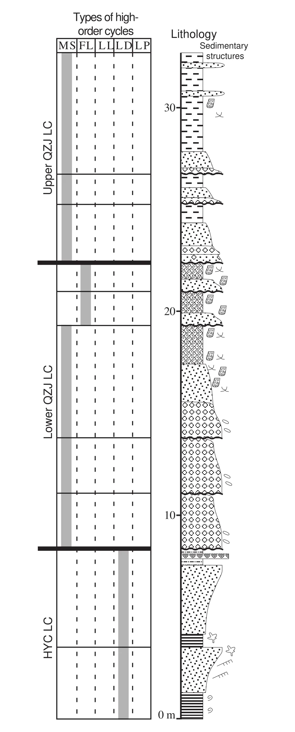
Figure 11 Highly-simplified lithologic column, sedimentary structures, and high?order cycle types of the HYC and lower and upper QZJ LCs of the Dalongkou section. Meandering stream and overbank deposits dominate in the lower QZJ LC with minor loess deposits. Three Argillisols occur in the upper part. See Fig?ure 5 for the legend and Figure 2 for the location of this measured section.
7 Delineation and stratigraphic correlation of LC boundaries
The geological events and processes interpreted from individual sections are similar and systematic, and form the foundation for stratigraphic correlation of the study interval (Figure 12). A pure lithostratigraphic correlation is not possible because of the lithological and stratigraphic complexities of the records. The trends of interpreted depositional environment changes and major controlling processes that caused these changes are used to establish process-response relationships, all of which facilitate the delineation of the lower QZJ LC and its time-stratigraphic correlation.
7.1 Uppermost HYC LC
The widespread lacustrine deposition of the uppermost HYC LC in the Tarlong-Taodonggou half graben and Dalongkou area indicates a dominantly lacustrine environment in both areas. However, the uppermost HYC deposits are not synchronous due to the variable amount of subsequent erosion and, thus, a detailed palaeoenvironmental and palaeogeographic reconstruction at the end of HYC time cannot be done. A series of events may have occurred during formation of the widespread disconformity and erosional unconformity capping the HYC lacustrine deposits. A lake withdrawal probably was caused by a tectonic uplift because sedimentary evidence in the uppermost HYC and basal QZJ deposits do not record significant drying (Yanget al., 2010). An episode of pedogenesis of the uppermost HYC sediments may have occurred locally. Variable degrees of pedogenesis occurred in most sections, except the SE Tarlong section.The pedogenic features may be the downward extension of overlying paleosols where they are in direct contact with the altered HYC lacustrine deposits, or they may have formed before lake withdrawal and subaerial exposure because Calcisols are common in the upper HYC LC (Yanget al., 2010). Fluvial erosion is evident in all sections after lake withdrawal, but the depth of downcutting varies greatly among sections. Two types of data are used in stratigraphic correlation to estimate the minimum topographic variations caused by fluvial erosion. The first datum is the top of the stacked paleosol interval in the basal QZJ in the northeastern, northern, and N-C Tarlong,Taodonggou, and Dalongkou sections. The second is the base of the first fluvial-loessial HC in the southeastern and SW Tarlong section where the paleosol interval is absent. The top of the paleosol intervals coincides with the base of the fluvial-loessial HCs in four other Tarlong-Taodonggou sections (Figure 12); thus, it is reasonable to use the data to correlate the seven sections. In addition,correlation of the conchostracan-rich bed in the upper HYC between N-C and N Tarlong sections indicates the erosional surface in N-C Tarlong is 7.5 m lower than that in N Tarlong. Correlation using aforementioned data indicates that the greatest downcutting is in the SW and SE Tarlong and Dalongkou sections at 101.6, 14, and 13.9 m,respectively. Similar topographic variations of the surface are reached by using the maximum-flooding surface in the lower HYC LC (Yanget al., 2010) or the base of the first deltaic deposits in the overlying Wutonggou LC. The pattern of topographic variations suggests that a major fluvial valley is present in the SW and SE Tarlong area and oriented approximately east to west (Figure 12). An episode of intense tectonic uplift is interpreted from the extensive fluvial erosion and rugged topography in the Tarlong-Taodonggou half graben and from the thick channel-fill complex in Dalongkou. These observations and interpretations suggest that the disconformity-erosional unconformity capping the uppermost HYC lacustrine deposits is regional and significant, across which major changes in environmental, tectonic, and climatic conditions occurred.Hence, the surface is a LC boundary, namely the base of the newly-defined lower QZJ LC. Yanget al.(2010) did not identify this surface as a LC boundary, because their interpretation was mainly based on data from the N Tarlong and Taodonggou sections.
7.2 Lower QZJ LC
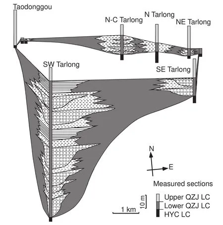
Figure 12 Fence diagram of the lower QZJ LC and adjacent strata in the Tarlong?Taodonggou half graben, showing lateral changes in thickness and lithofacies of fluvial valley and overbank deposits. The boundary between lower and upper QZJ LCs is the datum.Distance between measured sections is to scale. See Figure 5 for the legend and Figure 2 for the location of measured sections.
Meandering stream deposits filled the topographic lows at the lower boundary of the lower QZJ LC. Rugged topography and copious sediment supply, both of which were probably driven by intense tectonic uplift, resulted in thick and extensive meandering stream deposits. Stream channels concentrated in the valleys in NE, SW, and SE Tarlong as well as in Dalongkou, whereas overbank and small tributaries occupied areas outside the valley in the eastern part of NE Tarlong, N and N?C Tarlong, and Taodonggou. Slow sediment accumulation in overbank environments promoted pedogenesis, forming stacked paleosols. The rapid lateral facies and thickness changes are best demonstrated between the eastern and western subsections in NE Tarlong and Taodonggou (Figures 5,8). Repeated downcutting by younger streams into older channel fills supports the interpretation of episodic intense tectonic activity, which limited the fluvial accommodation space. The vicinity of SW Tarlong is probably the lowest area, where small, short?lived lakes developed by volcanic damming. The large amount of tuffs suggests a volcanic source nearby to SW Tarlong.
The intense meandering stream deposition eventu?ally tapered, signifying a reduced topographic gradient,stable landscape, and likely an enlarged drainage basin,which was probably caused by fluvial infilling, headwa?ter erosion, and tectonic quiescence. Intense pedogenesis expanded from the overbank area to the fluvial valleys,covering most of the Tarlong?Taodonggou half graben and the Dalongkou area, except SE and SW Tarlong.Stacked mature vertic Calcisols and calcareous Vertisols in the Tarlong?Taodonggou half graben suggest a semi?arid to arid climate with strong precipitation seasonality.However, vertic Argillisols in Dalongkou suggest a dif?ferent climate than that in Tarlong?Taodonggou half gra?ben. The interpretation is less certain due to the limited amount of data. It is speculated that the Argillisols formed in a subhumid climate with strong seasonality, which may have been caused by local climatic variations, such as an orographic rain shadow effect, or regional climatic change because the Dalongkou section is ~70 km to the north. Pedogenesis is minimal in the overbank deposits of meandering stream HCs in SE and SW Tarlong, where overbank deposition was more active than in the other ar?eas. Nonetheless, the widespread occurrence of stacked mature paleosols suggests a significant time period of minimal deposition and nondeposition, landscape stabil?ity, and tectonic quiescence. Hence, the top surface of the paleosol interval is likely a regional disconformity, which,locally changes to a correlative erosional unconformity in Taodonggou and a conformity in SW Tarlong. Yanget al.(2010) identified this surface as the boundary between HYC and QZJ LCs. Their interpretation is supported by this study and the surface now defines the upper boundary of the lower QZJ LC and the lower boundary of the recti?fied upper QZJ LC.
7.3 Basal upper QZJ LC
Renewed sedimentary deposition of alternating fluvial and loessial sediments occurred on top of the upper bound?ary of the lower QZJ LC in the Tarlong?Taodonggou half graben and Dalongkou area. The common occurrence of ephemeral stream and loessial deposits suggests a domi?nantly semi?arid climate. In addition, the common loes?sites suggest a change of atmospheric circulation patterns that affected regional wind regime. Loess accumulation may have started during the deposition of the uppermost part of the lower QZJ LC in the Dalongkou area, earlier than in the Tarlong?Taodonggou half graben. The differ?ence may be caused by spatial variations in wind regimes and source areas for loessial sediments or, alternatively,the lack of detailed analysis of host sediments of Calci?sols in the Tarlong?Taodonggou half graben. Future stud?ies shall clarify the cause of the difference. In addition,tectonic activity intensified during renewed deposition of basal upper QZJ LC, but was likely much less intense than that during the formation of the boundary between HYC and lower QZJ LCs and deposition of thick meandering stream systems in the lower part of the lower QZJ LC.Finally, we adapt Yanget al.’s (2010) definition of the up?per boundary of the upper QZJ LC, which separates the fluvial-loessial deposits of the upper QZJ LC from the lacustrine deltaic and meandering stream deposits of the Wutonggou LC.
8 Discussion
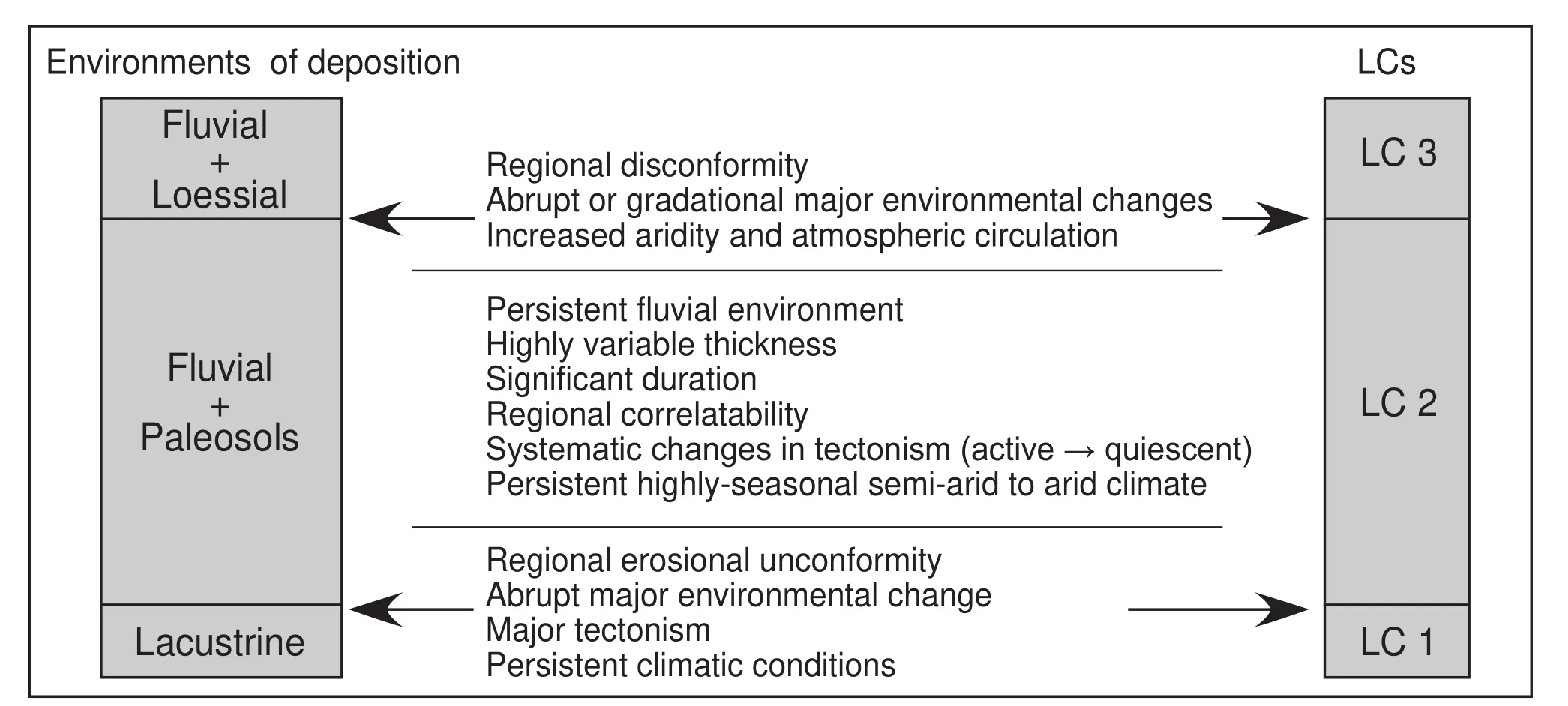
Figure 13 Schematic diagram showing the rationale behind the identification of LCs and their boundaries on the basis of magnitude of changes in environments of deposition, nature of stratigraphic surfaces as cycle boundaries, and trends of environmental change and tectonic and climatic conditions.
The criteria for establishing a LC should be its duration,regional correlatability, and magnitude of changes in depo?sitional environments and controlling processes across the cycle boundary, not its thickness (Figure 13). Yanget al.(2010) stated that “Low-order cycles are defined on the basis of similarity in types of HCs and ICs (intermediateorder cycles), which reflects the long-term trend of environmental changes and long-term stability of tectonic and/or climatic conditions. Low-order cycles are demarcated by regional unconformities and/or conformities, across which major changes in environment and tectonic and/or climatic conditions occurred.” The newly-defined lower QZJ LC meets these criteria. The lower boundary of the lower QZJ LC is a regional erosional unconformity and disconformity, where a significant amount of erosion had occurred. It should represent a large amount of geologi?cal time. The processes that formed and occurred during the unconformity include lake withdrawal, fluvial incision,and tectonic uplift, and are regional in scale. The upper boundary of the lower QZJ LC has similar attributes to those of the lower boundary, including regional fluvial infilling resulting in a subdued topography and landscape stability and pedogenesis signifying a prolonged period of tectonic quiescence. The HCs within the lower QZJ LC are all dominated by meandering stream deposits, representing active fluvial infilling followed by paleosol formation. The thickness of the LC varies over a wide range as determined by the rugged depositional topography and uneven distribution of stream channels and overbank environments, which are the norm for terrestrial environments in a rift setting. In addition, sedimentary environments and tectonic and/or climatic conditions changed drastically across both the lower and upper boundaries. Finally, the duration of the two boundaries and the lower QZJ LC is unknown but probably significant. Yanget al.(2010) interpreted the unconformable boundary between their HYC and QZJ LCs to have a maximum duration of ~14 Ma, on the basis of a U-Pb zircon age of 281.42±0.10 Ma of the tuff at the uppermost HYC at the SE Tarlong section and previous chronostratigraphic ages of the QZJ Formation.The new stratigraphic data and interpretations in this study suggest that a maximum 14-Ma duration is likely distributed among the lower and upper boundaries and the rocks of the lower QZJ LC. All the above evidence supports the establishment of the lower QZJ LC.
The identification of the newly-defined lower QZJ LC provides insights into the profound changes and evolution of sedimentary environments and the mechanisms of major allogenic processes that caused such changes. These changes and processes are recorded in a relatively thin and highly complex time-stratigraphic unit, the lower QZJ LC, in a highly-partitioned rift basin. This study demonstrates that only through detailed observations and careful sedimentological and stratigraphic analyses can such a significant time-stratigraphic unit be identified, and the process-response approach is effective in nonmarine timestratigraphic analysis. Finally, the lower QZJ LC provides an important tectonic and climatic record at the mid-latitude of NE Pangea during the mid-Permian icehousehothouse transition (Scotese, 2001; Fieldinget al., 2008).
9 Conclusions
1) A new synchronous cyclo-stratigraphic unit, the Middle Permian lower QZJ LC, is defined in the Tarlong-Taodonggou half graben in the southern foothills and the Dalongkou area ~70 km to the north in the northern foothills of the Bogda Mountains, NW China. It was the uppermost part of the previously-defined HYC LC, and consists of meandering stream deposits and stacked mature Calcisols and minor Argillisols and Vertisols in the upper part.Its lower boundary is a regional erosional unconformity separating the lacustrine deposits of the HYC LC from the overlying meandering stream deposits, and represents a regional lake withdrawal and significant fluvial incision,driven by an episode of intense tectonic uplift. Its upper boundary is a regional disconformity and correlative local erosional unconformity and conformity, separating the mature paleosols from overlying ephemeral and meandering stream and loessial deposits of the upper QZJ LC, and represents a prolonged episode of pedogenesis, tectonic quiescence, and a change of atmospheric circulation pattern. The lower QZJ LC is a significant time-stratigraphic unit of a significant duration, albeit its highly variable thickness ranging from 0 to 102 m.
2) Intense tectonic uplift occurred during the formation of the lower boundary and deposition of meandering stream systems of the lower QZJ LC. Tectonic uplift decreased during deposition of the upper part of the lower QZJ LC and tectonic quiescence occurred during pedogenesis and formation of the upper boundary. Tectonic activities increased moderately afterward.
3) Climatic conditions were semi-arid with strong precipitation seasonality in the Tarlong-Taodong-gou half graben during the formation of the lower QZJ LC, whereas conditions were subhumid with strong precipitation seasonality in the Dalongkou area, which may be caused by its northern location or local orographic effects. Atmospheric circulation patterns and wind regime changed in both areas after the formation of the upper boundary when loess deposition became dominant. The lower QZJ record serves as an important data point for tectonic and climatic conditions in the mid-latitude east coast of NE Pangea during the mid-Permian icehouse-hothouse transition.
4) This study demonstrates that a process-response approach, combined with detailed field observations and interpretation of controlling processes in a cyclostratigraphic context, is effective in identifying regional time surfaces and encompassing synchronous time-stratigraphic units of complex fluvial-lacustrine deposits in a rift setting.
Acknowledgements
We would like to thank Drs. J. Wang and M. L. Wan of Nanjing Institute of Geology and Paleontology of Chinese Academy of Sciences, Dr. Y. Yang of Xi’an Petroleum University, Dr. X. Luo of Institute of Geology and Geophysics, Chinese Academy of Sciences, Dr. Q. Feng of Shandong University of Science and Technology, S. S.Wang, J. J. Liu, T. Foster, Z. X. Li, J. J. Li, L. L. Cheng, C.C. Zhou, Y. M. Gao, and B. Sun for field, funding, and/or logistic assistance. This research was partially supported by four student research grants from Geological Society of America, Ed Picou/GCSSEPM, American Association of Petroleum Geologists, and the Al Spreng Graduate Research Grant from the Geology and Geophysics Program of Missouri University of Science and Technology to Jonathan Obrist-Farner, and by a research grant from University of Missouri Research Board and a research grant(No. 2011ZX05008-004-053) from Institute of Geology and Geophysics of Chinese Academy of Sciences to Wan Yang. Acknowledgement is made to the donors of the American Chemical Society Petroleum Research Fund, for a grant to Wan Yang. We are grateful to Professors Zeng-Zhao Feng, Jing-Tai Han, and an anonymous reviewer for the constructive comments that improved the quality of this contribution.
 Journal of Palaeogeography2015年1期
- Journal of Palaeogeography的其它文章
- Provenance and drainage system of the Early Cretaceous volcanic detritus in the Himalaya as constrained by detrital zircon geochronology
- 3D palaeogeographic reconstructions of the Phanerozoic versus sea-level and Sr-ratio variations
- Modern Black Sea oceanography applied to the end-Permian extinction event
- A revised Mississippian lithostratigraphy of County Galway (western Ireland) with an analysis of carbonate lithofacies, biostratigraphy, depositional environments and palaeogeographic reconstructions utilising new borehole data
- General regulations about submitting manuscripts to Journal of Palaeogeography
- 2nd International Palaeogeography Conference October 10?13, 2015