
Possibilities and challenges of expanding dimensions of waterway downstream of Three Gorges Dam
2019-07-24 07:35:04TaoYanYunpingYangYiingLiYuanfangChaiXiaoingCheng
Water Science and Engineering 2019年2期
Tao Yan , Yun-ping Yang , Yi-ing Li , Yuan-fang Chai , Xiao-ing Cheng ,*
a Key Laboratory of Yellow River Sediment Research, Ministry of Water Resources, Zhengzhou 450003, China
b Key Laboratory of Engineering Sediment, Tianjin Research Institute for Water Transport Engineering, Ministry of Transport, Tianjin 300456, China
c State Key Laboratory of Water Resources and Hydropower Engineering Science, Wuhan University, Wuhan 430072, China
AbstractThe waterway in the middle and lower reaches of the Yangtze River has long been known as the Golden Waterway and has served as an important link in the construction of the Yangtze River Economic Belt. Therefore, expanding its dimensions is a significant goal, particularly given the long-range cumulative erosion occurring downstream of the Three Gorges Dam(TGD),which has been concentrated in the dry river channel. With the regulation of the volume from upstream reservoirs and the TGD, the minimum discharge and water level of the river downstream are increasing,and creating favorable conditions for the increase of the depth of the waterway.The discharge compensation effect during the dry season offsets the decline in the water level of the river channel caused by the down-cutting of part of the riverbed, but the minimum navigable water level of the segment near the dam still shows a declining trend.In recent years,several waterway remediation projects have been implemented in the downstream reaches of the TGD and although the waterway depth and width have been increased, the channel dimensions are still insufficient in the Yichang-Anqing reach(with a total length of 1026 km),as compared to the upstream reservoir area and the deep water channel in the downstream tidal reaches. A comprehensive analysis of the water depth and the number and length of shoals in the waterway indicates that its dimensions can be increased to 4.5 m × 200 m and 6.0 m × 200 m in the Yichang-Wuhan and Wuhan-Anqing reaches, respectively. This is also feasible given the remediation technologies currently available, but remediation projects need to be coordinated with those for flood prevention and ecological protection.
Keywords: Waterway dimension; Condition analysis; Three Gorges Project; Yichang-Anqing reach; Yangtze River
1. Introduction
The navigability of a river depends on the dimensions(depth × width) of its waterway. In alluvial rivers, it is uncertain how much the water depth will increase due to natural erosion, and there is limited room for improvement.The development and expansion of the dimensions of a waterway can be achieved mainly by building reservoirs,damming, canalization, dredging, and revetment. All of these techniques have had favorable remediation effects on the Rhine (Zhao et al., 2000) and Mississippi (Williams and Wolman, 1984) rivers.
The waterway downstream of the Three Gorges Dam(TGD) is characterized by an increase in the minimum discharge during dry seasons, which directly increases its water depth. Meanwhile, the erosion of the downstream river channel caused by sediment-retaining effects increases the water depth of the waterway only when the down-cutting of the river channel due to erosion is greater than the decrease in the low water level. After the impoundment of the TGD,substantial erosion and thalweg down-cutting occurred downstream of the dam, mainly in the Yichang-Chenglingji reach (Fang et al., 2012; Yuan et al., 2012; Dai et al., 2013;Dai and Liu, 2013; Chen et al., 2016; Yang et al., 2018a).The Yichang-Zhicheng and Upper Jingjiang reaches are both characterized by beach and channel erosion, despite the impoundment,while conditions in the Lower Jingjiang-Hukou reach have been transformed from channel erosion and beach deposition to beach and channel erosion since the impoundment of the TGD (Xu et al., 2011, 2013; Xu, 2013). The Jingjiang reach has also experienced pronounced widening(Han et al.,2015),accompanied by significant bank collapse in unprotected areas (Xia et al., 2014a, 2014b, 2016). In braided reaches, erosion has developed faster in the tributaries than in the main streams,and the middle and lower beaches have been eroded,while the upper beach has collapsed(Zhu et al.,2015).The main navigation channels in the Shashi (Zhang et al.,2016) and Dongliu waterways have become dislocated(Jiang et al., 2010; Sun et al., 2011). In curved reaches, the beach of the convex bank has been eroded (Fan et al., 2017;Zhu et al., 2017), creating shoals that obstruct navigation in the entrance segment,reducing the barrier effect of the curved reaches, and increasing the upstream-downstream linkage in river regime adjustments (You et al., 2017b). In straight reaches, the moving speed of beaches accelerates; this affects their stability, as well as the stability of the main braided navigation channels downstream (Sun et al., 2013) and the channels of the reach (Liu et al., 2014). Thus, although there have been some unfavorable changes in the erosion patterns of the river channels downstream since the impoundment of the TGD, the cumulative erosion and increase in the minimum discharge are favorable conditions for increasing the water depth of the waterway.
In the middle and lower reaches of the Yangtze River, the waterway has long been known as the Golden Waterway(Cao et al., 2010). The development of its water depth is related to economic and social development in the area, and the Golden Waterway is relied upon to promote the construction of the Yangtze River Economic Belt, which has become a national strategy.Since the impoundment of the TGD,the depths of the waterways in the Yichang-Chenglingji, Chenglingji-Wuhan,Wuhan-Anqing, Anqing-Wuhu, and Wuhu-Nanjing reaches have increased from 2.9 m,3.2 m, 4.0 m, 4.5 m, and 6.0 m in 2002 to 3.5 m, 3.7 m, 4.5 m, 6.0 m, and 9.0 m in 2015 (Liu et al., 2017; Yang et al., 2017), respectively, through systematic waterway management (Yan et al., 2010; Jiang, 2014).The waterways in the Yichang-Wuhan and Wuhan-Anqing reaches (1026 km) are shallower than the upstream reservoir area and downstream tidal segments, respectively. Therefore,it is important to study how much further the dimensions of the waterway can be expanded.
Based on hydrological, topographical, and other data collected from 2003 to 2016, the changes in the minimum discharge, minimum water level of the river channel, river channel erosion and deposition, and minimum water level of the waterway downstream of the TGD were analyzed in this study. Furthermore, by analyzing information such as the depth of the waterway and number and length of the shoals obstructing navigation, the possibilities for expanding the dimensions of the waterway were determined. The results of model tests demonstrated the technical feasibility of expanding the dimensions of the waterway, and the possible constraints were also analyzed.
2. Overview of study region
The Yichang-Anqing reach is approximately 1026 km in length and includes the Yichang-Hukou reach, located in the middle part of the Yangtze River,and the Hukou-Anqing reach,located in the lower part of Yangtze River (Fig. 1). Shallower water depths are found in the Yichang-Wuhan and Wuhan-Anqing reaches than in the waterways in the upstream reservoir area and downstream tidal segments. Seven hydrological stations, Yichang, Zhicheng, Shashi, Jianli, Luoshan, Hankou,and Datong, are located in these reaches. From 2003 to 2016,the runoff volume at these hydrological stations decreased by 6.48%, 6.65%, 5.82%, 4.62%, 8.71%, 6.87%, and 9.67%,respectively,and sediment discharge decreased,respectively,by 90.43%, 88.78%, 84.03%, 77.71%, 72.87%, 67.61%, and 57.83%, compared to the period of 1990-2002 (Table 1).
3. Feasibility of upgrading water depth of waterway downstream of TGD
3.1. Minimum discharge and water levels
From 2009 to 2016, the annual minimum discharge of the Yichang, Shashi, Luoshan, Hankou, Jiujiang, and Datong stations all showed increasing trends when compared to 2003 to 2008.The mean values of the discharge increased by 1750 m3/s,1722 m3/s, 1760 m3/s, 1260 m3/s, 889 m3/s, and 2300 m3/s,respectively, and the maximum and minimum values also increased (Fig. 2(a)). The minimum water levels also showed increasing trends, with the mean values of the water level increasing by 0.76 m, 0.39 m, 1.82 m, 0.12 m, 0.05 m, and 0.14 m, respectively (Fig. 2(b)). The increase in the minimum discharge and water levels downstream of the TGD provides favorable conditions for increasing the waterway depth.
3.2. River channel erosion and deposition
From October 2002 to October 2016,the low-water channel and bank-water channel erosion volumes in the Yichang-Hukou reach were 19.70 × 10⁸m3and 18.51 × 10⁸m3,respectively(Fig.3),and the erosion intensities were 14.77×10⁴m3/(km·year) and 12.16 × 10⁴m3/(km·year), respectively.During this time,the mean thalweg down-cutting depth was 1.50 m in the Yichang-Chenglingji reach (approximately 410 km), 2.98 m in the Yichang-Zhicheng reach (approximately 60 km), and 0.15 m in the Chenglingji-Hukou reach.Meanwhile,the mean thalweg down-cutting depth was 1.12 m in the Yichang-Chenglingji reach, 2.25 m in the Yichang-Zhicheng reach, and 0.11 m in the Chenglingji-Hukou reach(Fig. 4). From 2003 to 2016, the navigational datum water level decreased by an average of 1.10 m within 240 km downstream of the Yichang Hydrological Station, compared to the period from 1981 to 2002; this value increased in the lower reach (the distance from the Yichang Hydrological Station was more than 240 km), indicating that thalweg down-cutting occurred mainly in the Yichang-Zhicheng,Upper Jingjiang (Zhicheng-Ouchikou), and Lower Jingjiang(Ouchikou-Chenglingji) reaches. The minimum navigable water level decreased mainly in the Yichang-Zhicheng and Upper Jingjiang reaches (Fig. 5). The cumulative erosion of the river channel makes it possible to upgrade the depth of the waterway.
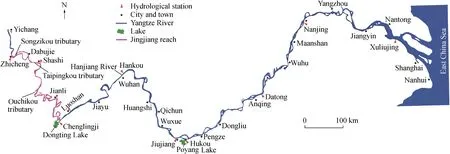
Fig. 1. Schematic of river channels downstream of TGD.
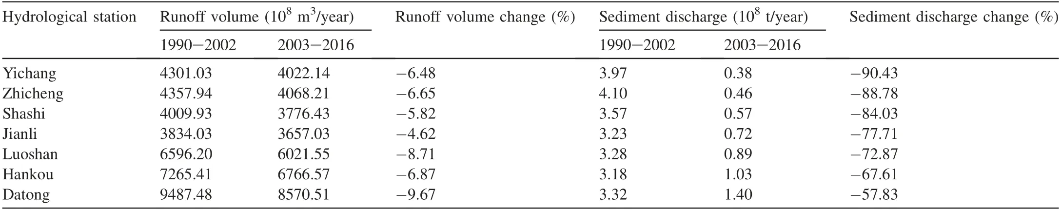
Table 1Changes in runoff volume and sediment discharge at hydrological stations in middle and lower reaches of Yangtze River.
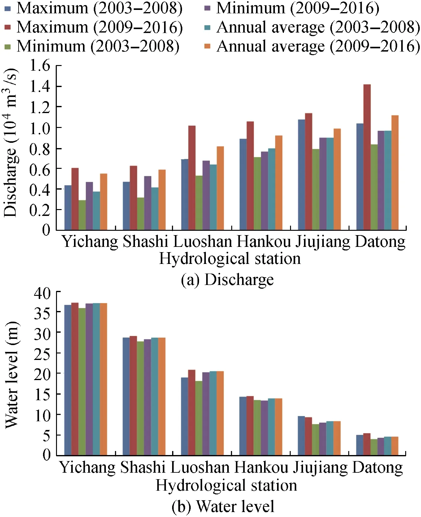
Fig.2.Changes in discharge and water levels at hydrological stations downstream of TGD.
3.3. Waterway remediation technologies
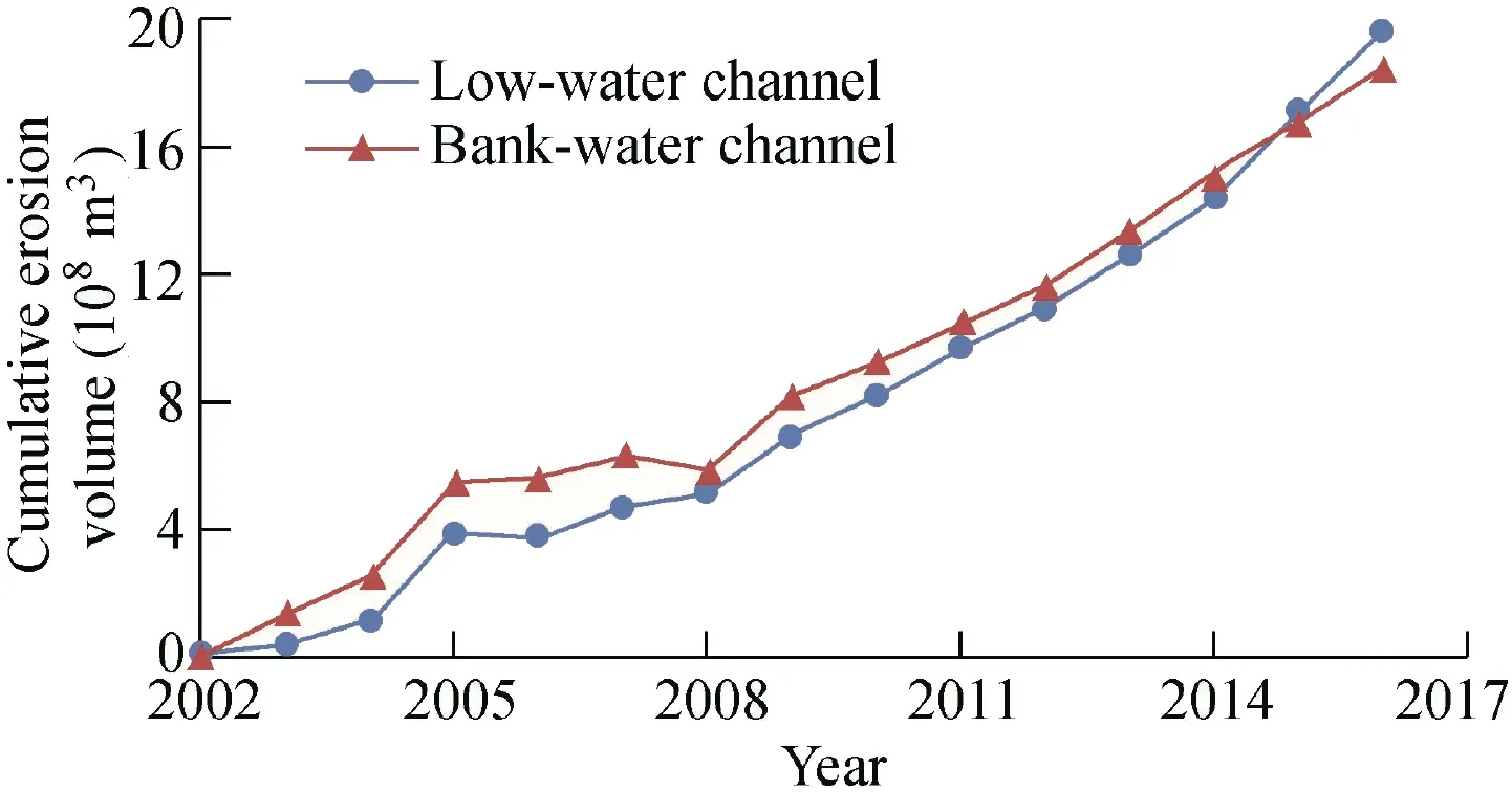
Fig.3. Cumulative erosion volume over time in low-water and bankwater channels.
As of December 2015, more than 300 waterway remediation structures had been built in the Yichang-Anqing reach(see Fig. 6 for the project layouts for different rivers). The types of projects can be divided into high beach protection,beach protection, and channel pattern-shaping works. High beach protection works are mainly employed to maintain the stability of the channel boundaries and to prevent the adverse effects caused by the widening of the channel scouring process. Beach protection works are mainly used to suppress the scouring of the edges and hearts of beaches,and to squeeze the current to scour the shallow areas of the channel in order to increase the depth of the channel. Channel pattern-shaping works are mainly undertaken to increase the water depth of the channel by means of compressing water through spur dikes, longitudinal dikes, and other infrastructure.
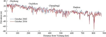
Fig. 4. Thalweg change along river channels in middle and lower reaches of Yangtze River.
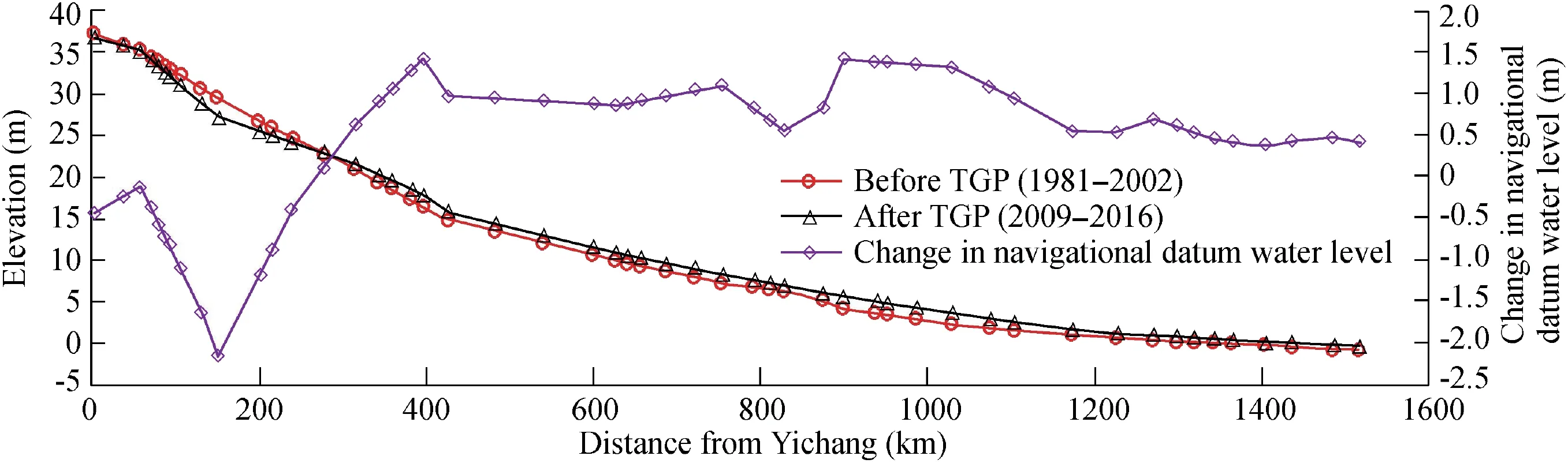
Fig. 5. Change in navigational datum water level before and after implementation of Three Gorges Project (TGP).
Different engineering measures have been taken according to the situations in different reaches. In the Fanzui and Shazhou reaches, as shown in Fig. 6(a) and (d), beach protection belts and revetment works have been undertaken to maintain the stability of the river pattern and channel boundaries. In the Jianli and Jiepai reaches, as shown in Fig.6(b)and(c),submersible spur dikes and revetment works have been adopted to maintain the stability of the shoreline and to scour the shallow area of the channel.In the Daijiazhou and Dongliu reaches,as shown in Fig.6(e)and(f),considering the large difference between the current channel depth and the planning objective, the comprehensive engineering measures of spur dikes, beach protection belts, and bottom protection have been employed to shape a favorable pattern and improve the water depth of the waterway.
As a result, a favorable beach pattern could be established and the dimensions of the waterway expanded. The water depths of the waterways in the Yichang-Chenglingji, Chenglingji-Wuhan, Wuhan-Anqing, Anqing-Wuhu, and Wuhu-Nanjing reaches increased from 2.9 m, 3.2 m, 4.0 m, 4.5 m,and 6.0 m in 2002 to 3.5 m,3.7 m,4.5 m,6.0 m,and 9.0 m in 2015, respectively. The goals planned in the Yangtze River waterway were achieved five years ahead of schedule (Liu et al., 2017; Yang et al., 2017). Several waterway remediation technologies have been developed after nearly 20 years,providing the engineering and technical bases needed for expanding the waterway dimensions (http://www.cinnet.cn;http://www.cwtca.org.cn).
4. Analysis of possibilities and challenges of expanding dimensions of waterway downstream of TGD
4.1. Changes in freight volume and ship type
Since 2003, the volumes of freight passing through the TGD and the Yangtze River Basin have both increased,reaching 130 million tons and 2.31 billion tons, respectively,in 2016,which represent 9.44-and 3.79-fold increases over the levels in 2003. The gross domestic product (GDP) growth of provinces along the watershed has outpaced the growth in waterborne transport volumes, indicating that the waterborne freight economy of the basin has lagged behind other economies within the watershed, as shown in Fig. 7. Therefore, an urgent need for increasing the depth of the waterway between Yichang and Anqing to meet the requirements of economic development along the Yangtze River has emerged.
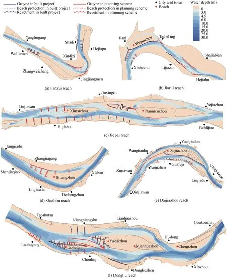
Fig. 6. Types of remediation projects in different reaches downstream of Yangtze River.
Ship types between Yichang and Anqing in 2005,2010,and 2015(Fig.8(a)and(b))were compared,and it was found that the proportion of ships with lengths of less than 30 m was no more than 5% in 2015. From 2005 to 2015, the proportion of ships with lengths between 30 m and 50 m decreased by 18%,while the proportions of ships with lengths of 50-90 m and 90-180 m increased by 18% and 7%, respectively. The number of ships with lengths greater than 180 m was essentially zero. Ship loadings in 2005, 2010, and 2015 were also compared. From 2005 to 2015, the proportions of ships with loadings of less than 1000 t and from 1000 to 2000 t decreased by 47%and 17%,respectively,while those with loadings from 2000 to 5000 t and greater than 5000 t increased by 34% and 30%, respectively. In summary, the ships in the Yichang-Anqing reach are becoming progressively larger. Although the waterway dimensions have expanded since the impoundment of the TGD,these waterways cannot satisfy the demands imposed by the increases in ship size.
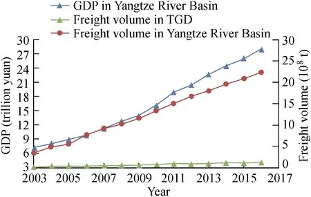
Fig. 7. Changes of freight volume and GDP in Yangtze River Basin.

Fig. 8. Statistical diagrams of ship types in Yichang-Anqing reach.
4.2. Analysis of water depth composition of waterway
Based on the waterway thalweg data (as shown in Fig. 4),the changes in waterway dimensions using the minimum navigable water level for 2009 to 2016 (Table 2) were investigated.Waterway depths(H)of H>5 m,4 m
Table 2Waterway depths and lengths in Yichang-Wuhan reach and Wuhan-Anqing reach.
The maintenance dimensions of the Yichang-Wuhan reach in the dry season are 3.5 m × 200 m to 3.8 m × 200 m.Considering the economic development along the river and the relationship between ship type and draft depth, the planning channel dimensions of each section were determined. A detailed inspection of the waterway sections in the Yichang-Wuhan reach, with dimensions of 4.0 m × 200 m,4.5 m × 100 m, 4.5 m × 200 m, 6.0 m × 100 m, and 6.0 m×200 m(Table 3),showed a total of 31,31,31,35,and 42 navigation-obstructing shoals,with shallow zone lengths of 7.10 km, 12.91 km, 18.80 km, 62.84 km, and 89.20 km,respectively. These zones respectively accounted for 1.14%,2.07%, 3.02%, 10.08%, and 14.31% of the total length of the waterway. In the 5.0 m × 200 m, 6.0 m × 100 m,6.0 m×200 m, 7.5 m×100 m, and 7.5 m×200 m sections of the waterway of the Wuhan-Anqing reach, there were 16,16, 16, 19, and 31 navigation-obstructing shoals, and the shallow zone lengths were 7.60 km, 13.55 km, 17.90 km,40.81 km, and 54.30 km, respectively. These zones respectively accounted for 1.89%, 3.37%, 4.45%, 10.14%, and 13.49% of the total length of the waterway. The waterway dimensions in the Yichang-Anqing reach thus possess the basic characteristics required for waterway expansion.
Although the waterway sections in the Yichang-Wuhan reach with H < 4.5 m, and those with H < 6.0 m in the Wuhan-Anqing reach have several shoals, the shoals rarely obstruct waterway navigation.However,if the water depths of the Yichang-Wuhan and Wuhan-Anqing reaches were increased to H>4.5 m and H>6.0 m,respectively,the degreeof navigational obstruction would increase several times over,and certain unfavorable conditions would be formed, such as navigation-obstructing shoal reaches,which would become the primary cause of navigational obstruction and increase the difficulty of waterway expansion. Given the aforementioned water depth conditions, we believe that the waterways in the Yichang-Wuhan and Wuhan-Anqing reaches could be increased to 4.5 m×200 m and 6.0 m×200 m,respectively.
Table 3Length and number of shallow zones with different channel dimensional upgrade targets.
4.3. Technical feasibility of expanding dimensions of waterway
Different remediation projects have been adopted for rivers with varying types and degrees of navigational obstruction.Invasive projects, such as those along the Jiepai, Daijiazhou,and Dongliu waterways, mainly use spur dikes or submerged spur dikes to retain water and remove sediments, finally deepening the navigation channel. Control and guiding projects, such as those along the Jianli, Daijiazhou, and Dongliu waterways, mainly increase or stabilize the diversion ratio of the main navigation routes by using fish-mouth-type devices to improve navigation conditions. Guarding-type projects primarily involve adopting techniques such as beach and bottom protection belts and bank protection to stabilize waterway boundaries and reduce the influence of obstructions on navigation conditions. These kinds of projects have been conducted on the Yichang-Changmenxi and Shazhou waterways.Blocking projects mainly use bottom protection belts or submerged spur dikes to limit the speed of developing tributaries and reduce the impact on main navigation routes.The Shazhou waterway is an example of this.In addition,dredging projects are mainly undertaken in the ecological protection zones and reaches in which river management is difficult; these are conducted after the implementation of project dredging during flood years in beach segments,such as those in the Shashi and Dongliu waterways. Non-engineering measures, such as reservoir regulation and storage, which are used to increase drainage discharge in dry seasons, directly increase water depth. Reservoir sediment retention promotes the erosion of the river downstream of the dam, which could increase the water depth of the waterway. However, the process of erosion is not balanced, the increase in the channel water depth is limited, and the timeframe required is relatively long.
The basic plan for expanding the dimensions of the waterway in the Yichang-Anqing reach is as follows:91 beach protection belts, 46.21 km of shore reinforcements, 87 submerged spur dams, 112.24 km of high dam guards, five dredging projects, 32 bottom protection belts, three reef explosion projects,and one cut-bank project.To demonstrate the technical feasibility of these waterway improvement measures,a mathematical model was constructed and a physical model with 15 beach sections was tested. In the process of mathematical modeling and physical testing, ten years representing different typical hydrological years, including 2010 to 2013,1998, and 2009 to 2013, were selected to carry out the calculations and physical tests. The work was completed in one year and the following conclusions were obtained:
(1) There are several impediments to navigation along major obstructed waterways, such as Yichang-Zhicheng, Shashi, Yaojianda, Xiongjizhou-Chenglingji, Jiepai (Fig. 6(c)),Wuqiao and Daijiazhou (Fig. 6(e)), and Madang and Dongliu(Fig. 6(f)), and these have not met the planned waterway standards for many years. The model results show that the required changes in planning can basically be achieved in the typical hydrological years(recently,the most serious waterway obstructions occurred in 2010 and 2012, as discussed below).However, in flood years (such as 1998), achieving planned waterway expansion goals still requires dredging and maintenance. Recently, it has been proposed that in the river reaches with a main stream and an alternative tributary, two separate routes should be chosen as the main navigational routes. The Jiepai and Dongliu waterways were used as examples.
(2) Generally obstructed waterways, such as Zhoutianou and Diaoguan-Laijiapu, Tiepu-Xiongjiazhou, Chibi-Panjiawan,Jinkou-Zhuankou, Tianxingzhou, Huguang-Luohuzhou, Guniusha, Liyushan, Xinzhou-Jiujiang, and Dongbei, are those not meeting the target waterway standards for individual years.The model results show that after a typical hydrological year, the waterway can reach the target dimensions.
(3) Potentially obstructed waterways, such as Nianziwan,Daorenji-Yanglinyan, Weizhou, Shazhou (Fig. 6(d)), and Qichun, are those already meeting the basic target waterway standards, although there are risks of development of navigational obstructions.The model results show that the stability of waterway and river boundary conditions can be maintained,and the target waterway length can be satisfied for a long time if key beach and shoreline reinforcements are adopted.
4.4. Challenges to upgrading dimensions of waterway
The upgrading of waterway dimensions will promote the development of the economy and society along the Yangtze River. However, upgrading waterway dimensions is still constrained by waterway remediation technology, river regime adjustments, flood control safety, the ecological environment,and other conditions,and thus there are significant challenges.Since there are a large number of waterway remediation projects that have been implemented in the middle and lower reaches of the Yangtze River and are still in the early stages of development, their remediation theory and technology, physical structures, and ecological and environmental protection measures can provide references for the waterway dimension upgrade project in the Yichang-Anqing reach.
(1) Waterway remediation technologies are difficult and waterway maintenance is a large-scale project.In the Yichang-Anqing reach, the shallow depths of waterways such as Lujiahe, Shashi, Jianli, Jiepai, Daijiazhou, and Dongliu severely obstruct navigation.The river regime in some reaches also changes drastically. To increase the water depths of the Yichang-Wuhan and Wuhan-Anqing reaches to 4.5 m and 6.0 m, respectively, long-range control and guiding projects are needed over a large scale and with large dimensions,while unbalanced, long-range erosion adjustments to the sandy riverbed make waterway maintenance difficult. In the early stage of waterway development, channel remediation works were implemented in reaches with more navigation obstructions, such as the Shashi, Jiepai, Daijiazhou, and Dongliu reaches.Through systematic channel remediation over the past ten years (2008-2018), the goal of channel dimension planning has been achieved, and the depth of the channel has increased by 0.5-1.5 m already. Meanwhile, according to the channel dimension upgrade target, the water depth increase should be 0.7-1.5 m. There is still a gap between reality and the goal; with increased difficulty, it is necessary to adopt staged projects and dredging measures to achieve the waterway upgrade goal.
(2) Large-scale waterway remediation affects the stability of river regimes and flood-control safety. Waterway remediation works are mainly implemented above the dry water level,increasing the resistance of the river to a certain extent.Some mid- and high-level water remediation works lead to changes in the mainstream impact point, threatening the embankment and bank stability, and affecting flood control.The report, Special Study on Flood Control Effects of Channel Regulation in Yichang-Anqing Section of the Yangtze River (CRSCI, 2015), showed that after the waterway remediation project was implemented, the maximum water cut-off rates for ten watercourses were from 5% to 12.2%,and that the water resistance of 19 watercourses ranged from 0 to 5%. Of these, the maximum water level of seven watercourses was 5.0-12.4 cm and that of 22 flood sections was 1-5 cm. It has been demonstrated that, since the impoundment of the TGD,the low water level of the middle and lower reaches of the Yangtze River has decreased with a constant discharge,but the flood level does not show such a declining trend(Yang et al.,2017,2018b).Additionally,some sections of the river appear to experience increased flood levels with the same discharge (Zhang et al., 2016). In the process of channel dimension upgrading,the influence of the project on flood levels should be minimized. Permeable structures or measures to reinforce the shoreline should be adopted.
(3) Large-scale waterway remediation needs to be coordinated with ecological protection. In recent years, there have been decreases, of varying degrees, in the populations of Acipenser sinensis (Zhou et al., 2014) and four other Chinese fish species (Yin et al., 2010). Some waterway remediation projects have been implemented in lowland or shoreline fish habitats,and their infrastructure will affect spawning,feeding,and wintering grounds, as well as migration paths (Li et al.,2013; You et al., 2017a). Some waterway projects have recently been abandoned due to ecological constraints (http://www.mep.gov.cn). At the same time, there have also been changes in the remediation of the buildings and materials used to manage the middle and lower reaches of the Yangtze River waterway;these have gradually become more environmentally friendly, thus reducing their ecological impacts (Liu, 2015;Liu et al., 2016). In 2016, the first phase of the channel remediation project of the Jingjiang reach in the middle reaches of the Yangtze River was completed. On-site monitoring results show that the structure of buildings adopted in the project initially played a significant role in the ecological environment. All of these findings can provide valuable references for waterway remediation works in the Yichang-Anqing reach.
5. Conclusions
After the impoundment of the TGD, significant erosion occurred in the river courses downstream, which provided favorable conditions for upgrading the dimensions of the waterway. Through analysis of the field data, and with consideration of the societal and economic needs along the middle and lower Yangtze River, the possibility of expanding the dimensions of the waterway was analyzed. The main conclusions are as follows:
(1)After the TGD was impounded,the amount of sediment downstream of the dam was reduced by 57.83%-90.43% and cumulative erosion occurred in the same region, especially in the segment near the dam. The discharge compensation effect during the dry season offset the decline in the water level of the waterway that was caused by the down-cutting of the riverbed. However, the minimum navigable water level of the segment near the dam still showed a declining trend. Further erosion of the river channel would lead to further declines in the low water level in the segment near the dam,which should be prevented.
(2) The successful implementation of the clean water discharge and large-scale waterway remediation projects downstream of the TGD has meant that goals for the Yangtze River waterway planned for completion in 2020 were achieved five years earlier. However, the depth of the waterways in the Yichang-Wuhan and Wuhan-Anqing reaches are still low compared to those in the upstream reservoir area and downstream deep-water channels. A comprehensive analysis of river channel erosion, minimum discharge, and the water depth change of the waterway indicates that there is a foundation for increasing and room to increase the dimensions of the waterway in the Yichang-Anqing reach.
(3)The examination of the dimensions of the waterway,as measured in multiple samples, and the comprehensive analysis of the number and length of the shoals obstructing navigation demonstrate that it is appropriate to expand the dimensions of the waterways in the Yichang-Wuhan and Wuhan-Anqing reaches to 4.5 m × 200 m and 6.0 m × 200 m, respectively. This is feasible in terms of the technologies needed, but the remediation projects also require coordination with flood prevention measures and ecological protection goals.
 Water Science and Engineering2019年2期
- Water Science and Engineering的其它文章
- Flume experimental study on evolution of a mouth bar under interaction of floods and waves
- Porosity and permeability variations of a dam curtain during dissolution
- Numerical simulation of flow separation over a backward-facing step with high Reynolds number
- River bank protection from ship-induced waves and river flow
- Submerged flexible vegetation impact on open channel flow velocity distribution: An analytical modelling study on drag and friction
- Correlations between silt density index, turbidity and oxidation-reduction potential parameters in seawater reverse osmosis desalination